Tuesday, August 8, 2017

FRANKLIN 0400 PM EDT AUG 8, 2017

000
WTNT32 KNHC 082033
TCPAT2

BULLETIN
Tropical Storm Franklin Advisory Number   9
NWS National Hurricane Center Miami FL       AL072017
400 PM CDT Tue Aug 08 2017

...FRANKLIN EXPECTED TO MOVE INTO THE BAY OF CAMPECHE SOON...


SUMMARY OF 400 PM CDT...2100 UTC...INFORMATION
----------------------------------------------
LOCATION...20.2N 90.3W
ABOUT 25 MI...40 KM NNE OF CAMPECHE MEXICO
MAXIMUM SUSTAINED WINDS...40 MPH...65 KM/H
PRESENT MOVEMENT...WNW OR 290 DEGREES AT 12 MPH...19 KM/H
MINIMUM CENTRAL PRESSURE...1001 MB...29.56 INCHES


WATCHES AND WARNINGS
--------------------
CHANGES WITH THIS ADVISORY:

None.

SUMMARY OF WATCHES AND WARNINGS IN EFFECT:

A Hurricane Watch is in effect for...
* The coast of Mexico from Puerto de Veracruz to Rio Panuco

A Tropical Storm Warning is in effect for...
* The coast of Mexico from Rio Lagartos to Sabancuy
* The coast of Mexico from Puerto de Veracruz to Rio Panuco

A Tropical Storm Watch is in effect for...
* The coast of Mexico from Sabancuy to Puerto de Veracruz

A Hurricane Watch means that hurricane conditions are possible
within the watch area.

A Tropical Storm Warning means that tropical storm conditions are
expected somewhere within the warning area within 36 hours.

A Tropical Storm Watch means that tropical storm conditions are
possible within the watch area.

For storm information specific to your area, please monitor
products issued by your national meteorological service.


DISCUSSION AND 48-HOUR OUTLOOK
------------------------------
At 400 PM CDT (2100 UTC), the center of Tropical Storm Franklin was
located near latitude 20.2 North, longitude 90.3 West. Franklin is
moving toward the west-northwest near 12 mph (19 km/h).  A mainly
westward motion is expected over the next couple of days.  On the
forecast track, the center of Franklin will move into the Bay of
Campeche in a few hours, move westward across the Bay of Campeche
tonight and Wednesday, and be near the coast of mainland Mexico
Wednesday night or early Thursday.

Maximum sustained winds are near 40 mph (65 km/h) with higher gusts.
A strengthening trend is likely to begin when the center moves
over water, and Franklin could be near hurricane intensity at
landfall in the southwest Gulf coast of Mexico.

Tropical-storm-force winds extend outward up to 140 miles (220 km)
from the center.

The estimated minimum central pressure is 1001 mb (29.56 inches).


HAZARDS AFFECTING LAND
----------------------
RAINFALL:  Franklin is expected to produce total rainfall
accumulations of 4 to 8 inches, and isolated maximum amounts of 12
inches are possible across portions of the Yucatan Peninsula of
Mexico through Wednesday.  Rainfall totals of 2 to 4 inches with
isolated maximum amounts of 8 inches are possible across northern
portions of Belize and northern portions of Guatemala.  Rainfall
totals of 4 to 8 inches with isolated maximum amounts of 15 inches
are possible across the Mexican states of Tabasco, northern
Veracruz, northern Puebla, Tlaxcala, Hidalgo, Queretaro and eastern
San Louis Potosi in eastern Mexico.  These rains may produce
life-threatening flash floods and mudslides.

WIND:  Tropical storm conditions may be occurring over portions of
the northern and western Yucatan peninsula.  Hurricane conditions
are possible within the Hurricane Watch area by Wednesday evening.
Tropical storm conditions are expected within the Tropical Storm
Warning area in mainland Mexico by Wednesday evening.  Tropical
storm conditions are possible within the tropical storm watch area
through Wednesday morning.

STORM SURGE:  A dangerous storm surge will raise water levels by
as much as 2 to 4 feet above normal tide levels along the
immediate coast near and to the north of where the center
makes landfall in the Hurricane Watch area.  Near the coast, the
surge will be accompanied by large and destructive waves.


NEXT ADVISORY
-------------
Next intermediate advisory at 700 PM CDT.
Next complete advisory at 1000 PM CDT.

$$
Forecaster Pasch 
 
 Ralph's Tropical Weather RTW  http://ralphstropicalweather.myfreesites.net


TROPICAL WEATHER OUTLOOK AUG 8, 2017 1209 PM EDT

RTW:  Ralph's Tropical Weather
1.  INVEST 99L Still being monitored for possible development by this weekend as it moves to a more favorable environment...RTW

2.  INFORMATION ON FRANKLIN REFER TO NATIONAL HURRICANE CENTER LINK ON THIS PAGE FOR UPDATES....RTW


http://ralphstropicalweather.myfreesites.net 


FRANKLIN UPDATE 1000 AM EDT AUG 8, 2017

000
WTNT32 KNHC 081432
TCPAT2

BULLETIN
Tropical Storm Franklin Advisory Number   8
NWS National Hurricane Center Miami FL       AL072017
1000 AM CDT Tue Aug 08 2017

...FRANKLIN EXPECTED TO MOVE INTO THE BAY OF CAMPECHE LATER TODAY...


SUMMARY OF 1000 AM CDT...1500 UTC...INFORMATION
-----------------------------------------------
LOCATION...19.6N 89.6W
ABOUT 60 MI...100 KM ESE OF CAMPECHE MEXICO
MAXIMUM SUSTAINED WINDS...45 MPH...75 KM/H
PRESENT MOVEMENT...WNW OR 290 DEGREES AT 13 MPH...20 KM/H
MINIMUM CENTRAL PRESSURE...1001 MB...29.56 INCHES


WATCHES AND WARNINGS
--------------------
CHANGES WITH THIS ADVISORY:

The government of Mexico has issued a Tropical Storm Warning for
the coast of mainland Mexico from Puerto de Veracruz to Rio
Panuco, and discontinued the Tropical Storm Warning for a portion of
the Yucatan Peninsula from east of Rio Lagartos and southward to
Chetumal.

SUMMARY OF WATCHES AND WARNINGS IN EFFECT:

A Hurricane Watch is in effect for...
* The coast of Mexico from Puerto de Veracruz to Rio Panuco

A Tropical Storm Warning is in effect for...
* The coast of Mexico from Rio Lagartos to Sabancuy
* The coast of Mexico from Puerto de Veracruz to Rio Panuco

A Tropical Storm Watch is in effect for...
* The coast of Mexico from Sabancuy to Puerto de Veracruz

A Hurricane Watch means that hurricane conditions are possible
within the watch area.

A Tropical Storm Warning means that tropical storm conditions are
expected somewhere within the warning area within 36 hours.

A Tropical Storm Watch means that tropical storm conditions are
possible within the watch area.

For storm information specific to your area, please monitor
products issued by your national meteorological service.


DISCUSSION AND 48-HOUR OUTLOOK
------------------------------
At 1000 AM CDT (1500 UTC), the center of Tropical Storm Franklin was
located near latitude 19.6 North, longitude 89.6 West. Franklin is
moving toward the west-northwest near 13 mph (20 km/h).  A
west-northwestward to westward motion is expected over the next
couple of days.  On the forecast track, the center of Franklin will
move into the Bay of Campeche later today, move westward across the
Bay of Campeche tonight and Wednesday, and be near the coast of
mainland Mexico Wednesday night or early Thursday.

Maximum sustained winds are near 45 mph (75 km/h) with higher gusts.
Some weakening is likely until the center moves back over water, and
strengthening is expected thereafter until landfall occurs in
mainland Mexico.

Tropical-storm-force winds extend outward up to 140 miles (220 km)
from the center.

The estimated minimum central pressure is 1001 mb (29.56 inches).


HAZARDS AFFECTING LAND
----------------------
RAINFALL:  Franklin is expected to produce total rainfall
accumulations of 4 to 8 inches and isolated maximum amounts of 12
inches are possible across portions of the Yucatan Peninsula of
Mexico through Wednesday.  Rainfall totals of 2 to 4 inches with
isolated maximum amounts of 8 inches are possible across northern
portions of Belize and northern portions of Guatemala.  Rainfall
totals of 4 to 8 inches with isolated maximum amounts of 15 inches
are possible across the Mexican states of Tabasco, northern
Veracruz, northern Puebla, Tlaxacala, Hidalgo, Queretar and eastern
San Louis Potosi in eastern Mexico.  These rains may produce
life-threatening flash floods and mudslides.

WIND:  Tropical storm conditions are likely still occurring over
portions of the northern and western Yucatan peninsula.
Hurricane conditions are possible within the Hurricane Watch area
by Wednesday evening.  Tropical storm conditions are expected
within the Tropical Storm Warning area in mainland Mexico by
Wednesday evening.  Tropical storm conditions are possible
within the tropical storm watch area today and tonight.

STORM SURGE:  A dangerous storm surge will raise water levels by
as much as 2 to 4 feet above normal tide levels along the
immediate coast near and to the north of where the center
makes landfall in the Hurricane Watch area.  Near the coast, the
surge will be accompanied by large and destructive waves.


NEXT ADVISORY
-------------
Next intermediate advisory at 100 PM CDT.
Next complete advisory at 400 PM CDT.

$$
Forecaster Pasch 
 
 Ralph's Tropical Weather RTW http://ralphstropicalweather.myfreesites.net
 

FRANKLIN UPDATE 05-08AM AUG 8, 2017 EDT POSITION

000
WTNT32 KNHC 081156
TCPAT2

BULLETIN
Tropical Storm Franklin Intermediate Advisory Number 7A
NWS National Hurricane Center Miami FL       AL072017
700 AM CDT Tue Aug 08 2017

...FRANKLIN MOVING OVER THE YUCATAN PENINSULA...


SUMMARY OF 700 AM CDT...1200 UTC...INFORMATION
----------------------------------------------
LOCATION...19.5N 89.1W
ABOUT 85 MI...140 KM NW OF CHETUMAL MEXICO
ABOUT 95 MI...155 KM ESE OF CAMPECHE MEXICO
MAXIMUM SUSTAINED WINDS...45 MPH...75 KM/H
PRESENT MOVEMENT...WNW OR 290 DEGREES AT 14 MPH...22 KM/H
MINIMUM CENTRAL PRESSURE...999 MB...29.50 INCHES


WATCHES AND WARNINGS
--------------------
CHANGES WITH THIS ADVISORY:

The government of Belize has discontinued the Tropical Storm
Warning for Belize.

SUMMARY OF WATCHES AND WARNINGS IN EFFECT:

A Hurricane Watch is in effect for...
* The coast of Mexico from Puerto de Veracruz to Rio Panuco

A Tropical Storm Warning is in effect for...
* The coast of Mexico from Chetumal to Sabancuy

A Tropical Storm Watch is in effect for...
* The coast of Mexico from Sabancuy to Puerto de Veracruz

A Hurricane Watch means that hurricane conditions are possible
within the watch area.  A watch is typically issued 48 hours
before the anticipated first occurrence of tropical-storm-force
winds, conditions that make outside preparations difficult or
dangerous.

A Tropical Storm Watch means that tropical storm conditions are
possible within the watch area, generally within 48 hours.

For storm information specific to your area, please monitor
products issued by your national meteorological service.


DISCUSSION AND 48-HOUR OUTLOOK
------------------------------
At 700 AM CDT (1200 UTC), the center of Tropical Storm Franklin was
located near latitude 19.5 North, longitude 89.1 West.  Franklin is
moving toward the west-northwest near 14 mph (22 km/h).  A
west-northwestward to westward motion is expected over the next
couple of days.  On the forecast track, the center of Franklin will
continue to move across the Yucatan peninsula today, and emerge over
the Bay of Campeche this evening or tonight.  Franklin will then
move westward across the Bay of Campeche on Wednesday.

Maximum sustained winds have decreased to near 45 mph (75 km/h)
with higher gusts.  Additional weakening is expected while Franklin
moves across the Yucatan peninsula today.  Restrengthening is
forecast to begin tonight and Wednesday while Franklin moves over
the Bay of Campeche.

Tropical-storm-force winds extend outward up to 140 miles (220 km)
from the center.

The estimated minimum central pressure is 999 mb (29.50 inches).


HAZARDS AFFECTING LAND
----------------------
RAINFALL:  Rainfall amounts of 3 to 6 inches, with isolated amounts
of around 12 inches, are possible across the Yucatan Peninsula of
Mexico and Belize through Wednesday, with the highest amounts over
the Mexican state of Quintana Roo.  In addition, Franklin is
expected to bring 4 to 8 inches of rainfall with isolated amounts
up to 15 inches through Thursday to northern Veracruz, Puebla,
Tlaxcala, Hidalgo, and eastern San Louis Potosi in eastern Mexico.
These rains will be capable of producing life-threatening flash
floods and mudslides.

WIND:  Tropical storm conditions are likely still occurring over
portions of the east coast of the Yucatan peninsula.  These
conditions should spread westward across the remainder of the
warning area today and diminish along the east coast of the Yucatan
peninsula later this morning.  Hurricane or tropical storm
conditions are possible within the hurricane watch area by late
Wednesday.  Tropical storm conditions are possible within the
tropical storm watch area tonight and Wednesday.


NEXT ADVISORY
-------------
Next complete advisory at 1000 AM CDT.

$$
Forecaster Pasch 


Monday, August 7, 2017

FRANKLIN UPDATE 1100 PM EDT AUG 7, 2017

000
WTNT32 KNHC 080241
TCPAT2

BULLETIN
Tropical Storm Franklin Advisory Number   6
NWS National Hurricane Center Miami FL       AL072017
1000 PM CDT Mon Aug 07 2017

...FRANKLIN POISED TO MAKE LANDFALL ON THE EAST COAST OF THE
YUCATAN PENINSULA VERY SOON...
...HEAVY RAINS AND FLASH FLOODING POSSIBLE ACROSS THE YUCATAN
PENINSULA AND BELIZE...


SUMMARY OF 1000 PM CDT...0300 UTC...INFORMATION
-----------------------------------------------
LOCATION...19.1N 87.3W
ABOUT 75 MI...125 KM ENE OF CHETUMAL MEXICO
ABOUT 75 MI...125 KM S OF TULUM MEXICO
MAXIMUM SUSTAINED WINDS...60 MPH...95 KM/H
PRESENT MOVEMENT...WNW OR 300 DEGREES AT 14 MPH...22 KM/H
MINIMUM CENTRAL PRESSURE...995 MB...29.39 INCHES


WATCHES AND WARNINGS
--------------------
CHANGES WITH THIS ADVISORY:

The government of Mexico has issued a Hurricane Watch for the coast
of mainland Mexico from Puerto de Veracruz northward to Rio Panuco.
The Tropical Storm Warning has been extended southward from
Campeche to Sabancuy, and a Tropical Storm Watch has been issued
west of Sabancuy to east of Puerto de Veracruz.  The Hurricane Watch
for the east coast of the Yucatan peninsula has been discontinued.

SUMMARY OF WATCHES AND WARNINGS IN EFFECT:

A Hurricane Watch is in effect for...
* The coast of Mexico from Puerto de Veracruz to Rio Panuco

A Tropical Storm Warning is in effect for...
* Belize City northward to the Belize/Mexico border
* The coast of Mexico from Chetumal to Sabancuy

A Tropical Storm Watch is in effect for...
* The coast of Mexico from Sabancuy to Puerto de Veracruz

A Hurricane Watch means that hurricane conditions are possible
within the watch area.  A watch is typically issued 48 hours
before the anticipated first occurrence of tropical-storm-force
winds, conditions that make outside preparations difficult or
dangerous.

A Tropical Storm Watch means that tropical storm conditions are
possible within the watch area, generally within 48 hours.

For storm information specific to your area, please monitor
products issued by your national meteorological service.


DISCUSSION AND 48-HOUR OUTLOOK
------------------------------
At 1000 PM CDT (0300 UTC), the center of Tropical Storm Franklin was
located near latitude 19.1 North, longitude 87.3 West.  Franklin is
moving toward the west-northwest near 14 mph (22 km/h).  A west-
northwestward to westward motion is expected during the next couple
of days.  On the forecast track, the center of Franklin will cross
the east coast of the Yucatan peninsula in the next hour or two,
traverse the Yucatan peninsula overnight and on Tuesday, and emerge
over the Bay of Campeche late Tuesday.  Franklin will then continue
westward across the Bay of Campeche on Wednesday.

Maximum sustained winds are near 60 mph (95 km/h) with higher gusts.
Weakening is expected while Franklin moves across the Yucatan
peninsula overnight and on Tuesday.  Restrengthening is forecast
Tuesday night and Wednesday while Franklin moves over the Bay of
Campeche.

Tropical-storm-force winds extend outward up to 140 miles (220 km)
from the center.

The estimated minimum central pressure is 995 mb (29.39 inches).


HAZARDS AFFECTING LAND
----------------------
RAINFALL:  Rainfall amounts of 3 to 6 inches, with isolated amounts
of around 12 inches, are possible across the Yucatan peninsula of
Mexico and Belize through Wednesday, with the highest amounts over
the Mexican state of Quintana Roo.  These rains could produce
life-threatening flash floods.

WIND:  Tropical storm conditions are likely occurring over portions
of the east coast of the Yucatan peninsula and should spread
westward across the remainder of the warning area overnight and on
Tuesday.  Hurricane or tropical storm conditions are possible within
the hurricane watch area by late Wednesday.  Tropical storm
conditions are possible within the tropical storm watch area
Tuesday night and Wednesday.

STORM SURGE:  A dangerous storm surge will raise water levels by
as much as 2 to 4 feet above normal tide levels along the immediate
coast near and to the north of where the center makes landfall.
Near the coast, the surge will be accompanied by large and
destructive waves.


NEXT ADVISORY
-------------
Next intermediate advisory at 100 AM CDT.
Next complete advisory at 400 AM CDT.

$$
Forecaster Berg 


FRANKLIN UPDATE 0400 PM EDT AUG 2017

000
WTNT32 KNHC 072032
TCPAT2

BULLETIN
Tropical Storm Franklin Advisory Number   5
NWS National Hurricane Center Miami FL       AL072017
400 PM CDT Mon Aug 07 2017

...FRANKLIN EXPECTED TO STRENGTHEN SOME MORE BEFORE LANDFALL...


SUMMARY OF 400 PM CDT...2100 UTC...INFORMATION
----------------------------------------------
LOCATION...18.6N 85.9W
ABOUT 170 MI...270 KM ENE OF BELIZE CITY
ABOUT 155 MI...255 KM E OF CHETUMAL MEXICO
MAXIMUM SUSTAINED WINDS...60 MPH...95 KM/H
PRESENT MOVEMENT...NW OR 310 DEGREES AT 13 MPH...20 KM/H
MINIMUM CENTRAL PRESSURE...998 MB...29.47 INCHES


WATCHES AND WARNINGS
--------------------
CHANGES WITH THIS ADVISORY:

None.

SUMMARY OF WATCHES AND WARNINGS IN EFFECT:

A Hurricane Watch is in effect for...
* The coast of Mexico from Chetumal to Punta Allen

A Tropical Storm Warning is in effect for...
* Belize City northward to the border of Mexico
* The coast of Mexico from Chetumal to Campeche

A Tropical Storm Watch is in effect for...
* The coast of Mexico from Campeche to Sabancuy

A Hurricane Watch means that hurricane conditions are possible
within the watch area, in this case within the next 24 hours.

A Tropical Storm Warning means that tropical storm conditions are
expected somewhere within the warning area, in this case within
24 hours.

A Tropical Storm Watch means that tropical storm conditions are
possible within the watch area.

Interests elsewhere around the Bay of Campeche should monitor the
progress of this system.  A Hurricane Watch may be required for a
portion of the southwestern Gulf coast of Mexico this evening.

For storm information specific to your area, please monitor
products issued by your national meteorological service.


DISCUSSION AND 48-HOUR OUTLOOK
------------------------------
At 400 PM CDT (2100 UTC), the center of Tropical Storm Franklin was
located near latitude 18.6 North, longitude 85.9 West. Franklin is
moving toward the northwest near 13 mph (20 km/h), and a
west-northwestward to westward motion is expected over the next 48
hours.  On the forecast track, the center will be near the east
coast of the Yucatan Peninsula this evening or tonight.  Franklin
is then expected to move across the Yucatan Peninsula on Tuesday,
and into the Bay of Campeche Tuesday evening or Tuesday night.

Maximum sustained winds are near 60 mph (95 km/h) with higher gusts.
Some strengthening is expected before the center reaches the
Yucatan Peninsula, and Franklin could be near hurricane intensity at
landfall on the east coast of the Yucatan Peninsula.

Tropical-storm-force winds extend outward up to 140 miles (220 km)
from the center.

The estimated minimum central pressure is 998 mb (29.47 inches).


HAZARDS AFFECTING LAND
----------------------
RAINFALL:  Rainfall amounts of 3 to 6 inches, with isolated amounts
of around 12 inches, are possible across the Yucatan Peninsula of
Mexico and Belize through Wednesday, with the highest amounts over
the Mexican state of Quintana Roo.  These rains could produce
life-threatening flash floods.

WIND:  Hurricane conditions are possible in the Hurricane Watch
area by this evening.  Tropical storm conditions are expected to
begin in portions of the warning area this afternoon or evening.
Tropical storm conditions are possible in the watch area in Mexico
on Tuesday.

STORM SURGE:  A dangerous storm surge will raise water levels by
as much as 2 to 4 feet above normal tide levels along the immediate
coast near and to the north of where the center makes landfall.
Near the coast, the surge will be accompanied by large and
destructive waves.


NEXT ADVISORY
-------------
Next intermediate advisory at 700 PM CDT.
Next complete advisory at 1000 PM CDT.

$$
Forecaster Pasch 


FRANKLIN INTERMEDIATE ADVISORY 0100 PM EDT AUG 7 2017

000
WTNT32 KNHC 071750
TCPAT2

BULLETIN
Tropical Storm Franklin Intermediate Advisory Number 4A
NWS National Hurricane Center Miami FL       AL072017
100 PM CDT Mon Aug 07 2017

...FRANKLIN EXPECTED TO STRENGTHEN SOME MORE BEFORE LANDFALL...


SUMMARY OF 100 PM CDT...1800 UTC...INFORMATION
----------------------------------------------
LOCATION...18.0N 85.4W
ABOUT 185 MI...300 KM E OF BELIZE CITY
ABOUT 195 MI...310 KM E OF CHETUMAL MEXICO
MAXIMUM SUSTAINED WINDS...60 MPH...95 KM/H
PRESENT MOVEMENT...WNW OR 300 DEGREES AT 13 MPH...20 KM/H
MINIMUM CENTRAL PRESSURE...999 MB...29.50 INCHES


WATCHES AND WARNINGS
--------------------
CHANGES WITH THIS ADVISORY:

None.

SUMMARY OF WATCHES AND WARNINGS IN EFFECT:

A Hurricane Watch is in effect for...
* The coast of Mexico from Chetumal to Punta Allen

A Tropical Storm Warning is in effect for...
* Belize City northward to the border of Mexico
* The coast of Mexico from Chetumal to Campeche

A Tropical Storm Watch is in effect for...
* The coast of Mexico from Campeche to Sabancuy

A Hurricane Watch means that hurricane conditions are possible
within the watch area, in this case within the next 24 hours.

A Tropical Storm Warning means that tropical storm conditions are
expected somewhere within the warning area, in this case within
24 hours.

A Tropical Storm Watch means that tropical storm conditions are
possible within the watch area.

Interests elsewhere around the Bay of Campeche should monitor the
progress of this system.

For storm information specific to your area, please monitor
products issued by your national meteorological service.


DISCUSSION AND 48-HOUR OUTLOOK
------------------------------
At 100 PM CDT (1800 UTC), the center of Tropical Storm Franklin was
located near latitude 18.0 North, longitude 85.4 West.  Franklin is
moving toward the west-northwest near 13 mph (20 km/h), and this
general motion is expected to continue over the next 48 hours.  On
the forecast track, the center of Franklin will be near the east
coast of the Yucatan peninsula by this evening.  Franklin is then
expected to move across the Yucatan Peninsula tonight and on
Tuesday.

Maximum sustained winds are near 60 mph (95 km/h) with higher
gusts.  Strengthening is forecast until the center reaches the east
coast of the Yucatan peninsula, and Franklin could be near hurricane
strength by the time landfall occurs this evening or tonight.  Some
weakening is likely while the system moves across the Yucatan
Peninsula on Tuesday.

Tropical-storm-force winds extend outward up to 140 miles (220 km)
from the center.

The minimum central pressure reported by an Air Force Hurricane
Hunter aircraft is 999 mb (29.50 inches).


HAZARDS AFFECTING LAND
----------------------
RAINFALL:  Rainfall amounts of 3 to 6 inches, with isolated amounts
of around 12 inches, are possible across the Yucatan Peninsula of
Mexico and Belize through Wednesday, with the highest amounts over
the Mexican state of Quintana Roo.  These rains could produce
life-threatening flash floods.

WIND:  Hurricane conditions are possible in the Hurricane Watch
area by this evening.  Tropical storm conditions are expected to
begin in portions of the warning area this afternoon or evening.
Tropical storm conditions are possible in the watch area in Mexico
on Tuesday.

STORM SURGE:  A dangerous storm surge will raise water levels by
as much as 2 to 4 feet above normal tide levels along the immediate
coast near and to the north of where the center makes landfall.
Near the coast, the surge will be accompanied by large and
destructive waves.


NEXT ADVISORY
-------------
Next complete advisory at 400 PM CDT.

$$
Forecaster Pasch


LANDFALL PROBABILITIES FOR THIS SEASON INCREASED TO 61%

Forecast update for storm landfall this season along the Florida coast increased from 51% to 61%. We need to be Hurricane Ready!

https://twitter.com/WPLGLocal10/status/894616650737221632 

FRANKLIN MAY ALREADY BE A HURRICANE AUG 7, 2017 0135 PM EDT

Seems to me that when Air Force Recon plane reaches to storm it may be Hurricane Franklin. This looks like an eye trying to form north of where 1000 AM coordinate location. You can see the buzz saw shape it has taken and the inflow and outflow clouds all around the cyclone looking rather impressive. Water temps 30° C which equates to 86° F very warn sea surface temps, tropical cyclone fuel to thrive on...RTW

TROPCIAL WEATHER OUTLOOK AUG 7, 2017 1205 PM EDT

RTW:  Ralph's Tropical Weather
1.  Another strong wave or cluster of storms way South of the Cape Verde Islands (Islas de Cabo Verde) is tracking west...RTW


2.  INVEST 99L still not well organized seems to be affected by dry air and some wind shear.  I will continue to watch it....RTW

3.  TROPICAL STORM FRANKLIN FORMS IN THE NORTHWEST CARIBBEAN REFER TO NATIONAL HURRICANE CENTER LINK ON THIS PAGE FOR UPDATES.   A THREAT TO MEXICO, BUT NOT A THREAT TO THE U.S....RTW


http://ralphstropicalweather.myfreesites.net 

FRANKLIN UPDATE 1000 AM EDT AUG 7, 2017

000
WTNT32 KNHC 071433
TCPAT2

BULLETIN
Tropical Storm Franklin Advisory Number   4
NWS National Hurricane Center Miami FL       AL072017
1000 AM CDT Mon Aug 07 2017

...FRANKLIN CONTINUES TO GRADUALLY STRENGTHEN...


SUMMARY OF 1000 AM CDT...1500 UTC...INFORMATION
-----------------------------------------------
LOCATION...17.7N 85.1W
ABOUT 205 MI...330 KM E OF BELIZE CITY
ABOUT 215 MI...350 KM ESE OF CHETUMAL MEXICO
MAXIMUM SUSTAINED WINDS...60 MPH...95 KM/H
PRESENT MOVEMENT...WNW OR 300 DEGREES AT 14 MPH...22 KM/H
MINIMUM CENTRAL PRESSURE...999 MB...29.50 INCHES


WATCHES AND WARNINGS
--------------------
CHANGES WITH THIS ADVISORY:

None.

SUMMARY OF WATCHES AND WARNINGS IN EFFECT:

A Hurricane Watch is in effect for...
* The coast of Mexico from Chetumal to Punta Allen

A Tropical Storm Warning is in effect for...
* Belize City northward to the border of Mexico
* The coast of Mexico from Chetumal to Campeche

A Tropical Storm Watch is in effect for...
* The coast of Mexico from Campeche to Sabancuy

A Hurricane Watch means that hurricane conditions are possible
within the watch area, in this case within the next 24 hours.

A Tropical Storm Warning means that tropical storm conditions are
expected somewhere within the warning area, in this case within
24 hours.

A Tropical Storm Watch means that tropical storm conditions are
possible within the watch area.

Interests elsewhere around the Bay of Campeche should monitor the
progress of this system.

For storm information specific to your area, please monitor
products issued by your national meteorological service.


DISCUSSION AND 48-HOUR OUTLOOK
------------------------------
At 1000 AM CDT (1500 UTC), the center of Tropical Storm Franklin was
located near latitude 17.7 North, longitude 85.1 West.  Franklin is
moving toward the west-northwest near 14 mph (22 km/h), and this
general motion is expected to continue over the next 48 hours.  On
the forecast track, the center of Franklin will be near the east
coast of the Yucatan peninsula by this evening.  Franklin is then
expected to move across the Yucatan Peninsula tonight and on
Tuesday.

Maximum sustained winds are near 60 mph (95 km/h) with higher gusts.
Strengthening is forecast until the center reaches the east coast
of the Yucatan peninsula, and Franklin could be near hurricane
strength by the time landfall occurs this evening or tonight.  Some
weakening is likely while the system moves across the Yucatan
Peninsula on Tuesday.

Tropical-storm-force winds extend outward up to 140 miles (220 km)
from the center.

The estimated minimum central pressure is 999 mb (29.50 inches).


HAZARDS AFFECTING LAND
----------------------
RAINFALL:  Rainfall amounts of 3 to 6 inches, with isolated amounts
of around 12 inches, are possible across the Yucatan Peninsula of
Mexico and Belize through Wednesday, with the highest amounts over
the Mexican state of Quintana Roo.  These rains could produce
life-threatening flash floods.

WIND:  Hurricane conditions are possible in the Hurricane Watch
area by this evening.  Tropical Storm conditions are expected to
begin in portions of the warning area this afternoon or evening.
Tropical Storm conditions are possible in the watch area in Mexico
on Tuesday.

STORM SURGE:  A dangerous storm surge will raise water levels by
as much as 2 to 4 feet above normal tide levels along the immediate
coast near and to the north of where the center makes landfall.
Near the coast, the surge will be accompanied by large and
destructive waves.


NEXT ADVISORY
-------------
Next intermediate advisory at 100 PM CDT.
Next complete advisory at 400 PM CDT.

$$
Forecaster Pasch 


 LATEST SATELLITE REVIEW OF FRANKLIN SUGGEST THAT FRANKLIN IS MATURING INTO A HURRICANE QUICKLY.  RTW


TRACKING THE TROPICS AUG 7 2017 1040 AM EDT

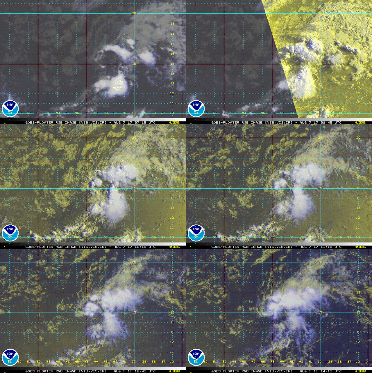
Invest 99L is moving through dry air and this has been hindering development.  However, regardless of the dry air this system seems to have developed some moisture and storms are consolidating once again.  Upper level environment ahead of this system near 60°N is unfavorable due to a mid to upper level low north of Puerto Rico.  Development if any will be slow to occur.  As for the models I would not pay to much attention to them since we have a disorganized system that could go where ever the steering currents take it.  RTW