Wednesday, July 29, 2020

TROPICAL STORM ISAIAS FORMS SOUTH OF PUERTO RICO


Just as I thought that right shift in model tracks would shift NHC track as well.  I wouldn't be surprised if by morning it shifts further east.
RTW
000
WTNT34 KNHC 300248
TCPAT4

BULLETIN
Tropical Storm Isaias Advisory Number   7
NWS National Hurricane Center Miami FL       AL092020
1100 PM AST Wed Jul 29 2020

...DISTURBANCE BECOMES TROPICAL STORM ISAIAS (PRONOUNCED 
ees-ah-EE-ahs)...


SUMMARY OF 1100 PM AST...0300 UTC...INFORMATION
-----------------------------------------------
LOCATION...15.8N 67.0W
ABOUT 155 MI...250 KM S OF PONCE PUERTO RICO
ABOUT 265 MI...430 KM SE OF SANTO DOMINGO DOMINICAN REPUBLIC
MAXIMUM SUSTAINED WINDS...50 MPH...85 KM/H
PRESENT MOVEMENT...WNW OR 285 DEGREES AT 20 MPH...31 KM/H
MINIMUM CENTRAL PRESSURE...1004 MB...29.65 INCHES


WATCHES AND WARNINGS
--------------------
CHANGES WITH THIS ADVISORY:

The government of Antigua has discontinued the Tropical Storm
Warning for Anguilla.

The government of the Bahamas has upgraded the Tropical Storm Watch
for the Central Bahamas to a Tropical Storm Warning and has issued a
Tropical Storm Watch for the Northwestern Bahamas.

SUMMARY OF WATCHES AND WARNINGS IN EFFECT:

A Tropical Storm Warning is in effect for...
* Puerto Rico, Vieques, Culebra
* U.S. Virgin Islands
* British Virgin Islands
* St. Martin and St. Barthelemy
* Saba and St. Eustatius
* St. Maarten
* Dominican Republic entire southern and northern coastlines
* North coast of Haiti from Le Mole St Nicholas eastward to the
northern border with the Dominican Republic
* Turks and Caicos Islands
* Southeastern Bahamas including the Acklins, Crooked Island, Long
Cay, the Inaguas, Mayaguana, and the Ragged Islands
* Central Bahamas, including Cat Island, the Exumas, Long Island,
Rum Cay, and San Salvador

A Tropical Storm Watch is in effect for...
* Northwestern Bahamas including Andros Island, New Providence,
Eleuthera, Abacos Islands, Berry Islands, Grand Bahamas Island, and
Bimini

Interests in Cuba and the Florida peninsula should monitor the
progress of this system.

A Tropical Storm Warning means that tropical storm conditions are
expected somewhere within the warning area within 36 hours.

A Tropical Storm Watch means that tropical storm conditions are
possible within the watch area, generally within 48 hours.

For storm information specific to your area in the United
States, including possible inland watches and warnings, please
monitor products issued by your local National Weather Service
forecast office. For storm information specific to your area
outside of the United States, please monitor products issued by
your national meteorological service.


DISCUSSION AND OUTLOOK
----------------------
At 1100 PM AST (0300 UTC), the center of Tropical Storm Isaias was
located near latitude 15.8 North, longitude 67.0 West. Isaias is
moving toward the west-northwest near 20 mph (31 km/h), and a 
west-northwestward to northwestward motion with some decrease in 
forward speed is expected over the next couple of days.  On the 
forecast track, the center of Isaias will move over Hispaniola on 
Thursday and near the Southeastern Bahamas by early Friday.

Maximum sustained winds are near 50 mph (85 km/h) with higher gusts.
Some weakening is likely when the center moves over Hispaniola 
with some strengthening expected by Friday.

Tropical-storm-force winds extend outward up to 345 miles (555 km)
mainly to the northeast of the center.

The estimated minimum central pressure is 1004 mb (29.65 inches).


HAZARDS AFFECTING LAND
----------------------
Key messages for Isaias can be found in the Tropical Cyclone
Discussion under AWIPS header MIATCDAT4, WMO header WTNT44 KNHC, and
on the web at www.hurricanes.gov/text/MIATCDAT4.shtml.

WIND:  Tropical storm conditions will continue across portions of
the Leeward Islands, the U.S. and British Virgin Islands and Puerto
Rico through tonight.  These conditions are forecast to reach
portions of the Dominican Republic and Haiti within the warning area
by late tonight or early Thursday, and the southeastern Bahamas and
Turks and Caicos Thursday afternoon.  Tropical storm conditions are
expected in the Central Bahamas beginning Friday morning and are 
possible in the northwestern Bahamas beginning late Friday.

RAINFALL: Isaias is expected to produce the following rain
accumulations:

Across the British and U.S. Virgin Islands and Turks and Caicos: 3
to 6 inches.

Across Puerto Rico, the Dominican Republic, northern Haiti, and
eastern Cuba: 3 to 6 inches, with isolated maximum totals of 8
inches.

Across the southeastern Bahamas: 4 to 8 inches.

These rainfall amounts may lead to life-threatening flash flooding
and mudslides, as well as potential riverine flooding beginning
today.  Urban and small stream flooding is expected for the U.S.
Virgin Islands, eastern Puerto Rico, and Hispaniola.

SURF:  Swells generated by Isaias will be affecting portions of the
Leeward Islands, the Virgin Islands, and Puerto Rico through
Thursday.  These swells are forecast to reach the north coast of
the Dominican Republic, the Turks and Caicos Islands and the
southeastern Bahamas tonight or Thursday.  These swells are likely
to cause life-threatening surf and rip current conditions.  Please
consult products from your local weather office.


NEXT ADVISORY
-------------
Next intermediate advisory at 200 AM AST.
Next complete advisory at 500 AM AST.

$$
Forecaster Pasch
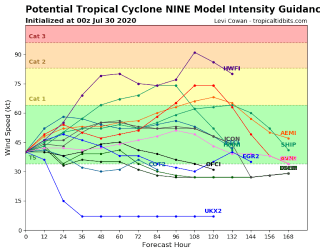


PTC NINE 0800 PM UPDATE


LATEST EURO AND GFS ARE BACK ON THE RIGHT SIDE OF THE TRACK OFF THE EAST COAST OF FLORIDA, AND OVER THE WESTERN BAHAMA'S.  WILL SEE IF THE NHC OFFICIAL FORECAST SHIFTS EAST DURING THE 11 PM FORECAST.

000
WTNT34 KNHC 292336
TCPAT4

BULLETIN
Potential Tropical Cyclone Nine Intermediate Advisory Number 6A
NWS National Hurricane Center Miami FL       AL092020
800 PM AST Wed Jul 29 2020

...DISTURBANCE CONTINUES TO BRING HEAVY RAINFALL AND GUSTY WINDS TO
THE U.S. AND BRITISH VIRGIN ISLANDS AND PUERTO RICO...


SUMMARY OF 800 PM AST...0000 UTC...INFORMATION
----------------------------------------------
LOCATION...16.0N 66.3W
ABOUT 140 MI...225 KM S OF PONCE PUERTO RICO
ABOUT 280 MI...450 KM SE OF SANTO DOMINGO DOMINICAN REPUBLIC
MAXIMUM SUSTAINED WINDS...45 MPH...75 KM/H
PRESENT MOVEMENT...WNW OR 285 DEGREES AT 18 MPH...30 KM/H
MINIMUM CENTRAL PRESSURE...1004 MB...29.65 INCHES


WATCHES AND WARNINGS
--------------------
CHANGES WITH THIS ADVISORY:

None.

SUMMARY OF WATCHES AND WARNINGS IN EFFECT:

A Tropical Storm Warning is in effect for...
* Puerto Rico, Vieques, Culebra
* U.S. Virgin Islands
* British Virgin Islands
* Anguilla
* St. Martin and St. Barthelemy
* Saba and St. Eustatius
* St. Maarten
* Dominican Republic entire southern and northern coastlines
* North coast of Haiti from Le Mole St Nicholas eastward to the
northern border with the Dominican Republic
* Turks and Caicos Islands
* Southeastern Bahamas including the Acklins, Crooked Island, Long
Cay, the Inaguas, Mayaguana, and the Ragged Islands

A Tropical Storm Watch is in effect for...
* Central Bahamas, including Cat Island, the Exumas, Long Island,
Rum Cay, and San Salvador

Interests in the northwestern Bahamas and Cuba should monitor the
progress of this system.

A Tropical Storm Warning means that tropical storm conditions are
expected somewhere within the warning area within 36 hours.

A Tropical Storm Watch means that tropical storm conditions are
possible within the watch area, generally within 48 hours.

For storm information specific to your area in the United
States, including possible inland watches and warnings, please
monitor products issued by your local National Weather Service
forecast office. For storm information specific to your area
outside of the United States, please monitor products issued by
your national meteorological service.


DISCUSSION AND OUTLOOK
----------------------
At 800 PM AST (0000 UTC), the disturbance was centered near latitude
16.0 North, longitude 66.3 West.  The system is moving toward the
west-northwest near 18 mph (30 km/h), and this general motion with a
reduction in forward speed is expected over the next few days.  On
the forecast track, the system will continue to pass south of Puerto
Rico tonight, near or over Hispaniola on Thursday, near eastern Cuba
and the southeastern Bahamas on Friday, and approach the
northwestern Bahamas and southern Florida Friday night.

Maximum sustained winds are near 45 mph (75 km/h) with higher
gusts.  Some increase in strength is forecast through tonight, with
weakening likely on Thursday due to land interaction.  Some
restrengthening is possible by this weekend.

Environmental conditions are expected to be conducive for
additional development, and a tropical storm is forecast to form
tonight.
* Formation chance through 48 hours...high...90 percent
* Formation chance through 5 days...high...90 percent  
Tropical-storm-force winds extend outward up to 275 miles (445 km)
primarily to the north of the center.

The estimated minimum central pressure is 1004 mb (29.65 inches).


HAZARDS AFFECTING LAND
----------------------
Key messages for Potential Tropical Cyclone Nine can be found in
the Tropical Cyclone Discussion under AWIPS header MIATCDAT4, WMO
header WTNT44 KNHC, and on the web at
www.hurricanes.gov/text/MIATCDAT4.shtml.

WIND:  Tropical storm conditions will continue across portions of
the Leeward Islands, the U.S. and British Virgin Islands and Puerto
Rico through tonight.  These conditions are forecast to reach
portions of the Dominican Republic and Haiti within the warning area
by late tonight or early Thursday, and the southeastern Bahamas and
Turks and Caicos Thursday afternoon. Tropical storm conditions are
possible in the watch area on Friday.

RAINFALL:  The disturbance is expected to produce the following
rain accumulations:

Across the northern Leeward Islands, British and U.S. Virgin
Islands: 3 to 6 inches.

Across Puerto Rico: 3 to 6 inches, with isolated maximum totals of
10 inches.

Across the Dominican Republic, northern Haiti, and Turks and Caicos:
3 to 6 inches, with isolated maximum totals of 8 inches.

Across the Inagua Islands and southeastern Bahamas: 4 to 8 inches.

These rainfall amounts may lead to life-threatening flash flooding
and mudslides, as well as potential riverine flooding beginning
today. Urban and small stream flooding is expected for the U.S.
Virgin Islands and eastern Puerto Rico.

SURF:  Swells generated by Potential Tropical Cyclone Nine will be
affecting portions of the Leeward Islands, the Virgin Islands and
Puerto Rico through Thursday. These swells are forecast to
reach the north coast of the Dominican Republic, the Turks and
Caicos Islands and the southeastern Bahamas tonight or Thursday.
These swells are likely to cause life-threatening surf and rip
current conditions.  Please consult products from your local
weather office.


NEXT ADVISORY
-------------
Next complete advisory at 1100 PM AST.

$$
Forecaster Pasch


EURO MODEL
GFS MODEL

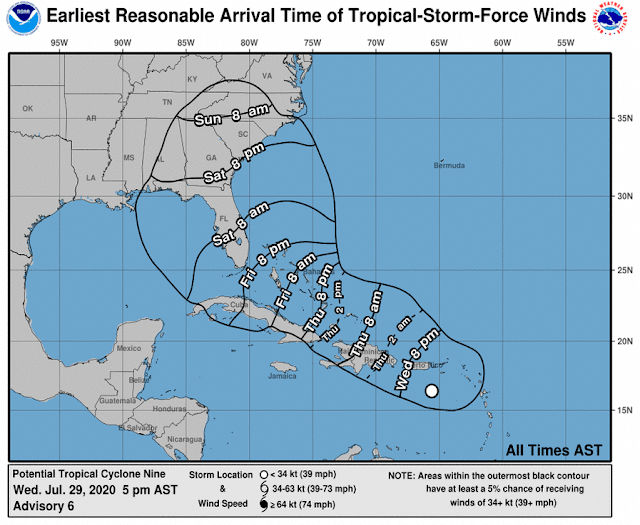
PTC NINE 0500 PM EDT JULY 29, 2020


ZCZC MIATCPAT4 ALL
TTAA00 KNHC DDHHMM

BULLETIN
Potential Tropical Cyclone Nine Advisory Number   6
NWS National Hurricane Center Miami FL       AL092020
500 PM AST Wed Jul 29 2020

...HEAVY RAINFALL AND GUSTY WINDS CONTINUE TO SPREAD OVER THE
LEEWARD ISLANDS...THE U.S. AND BRITISH VIRGIN ISLANDS...AND PUERTO
RICO...


SUMMARY OF 500 PM AST...2100 UTC...INFORMATION
----------------------------------------------
LOCATION...16.4N 65.6W
ABOUT 105 MI...170 KM SSW OF ST. CROIX
ABOUT 320 MI...510 KM ESE OF SANTO DOMINGO DOMINICAN REPUBLIC
MAXIMUM SUSTAINED WINDS...45 MPH...75 KM/H
PRESENT MOVEMENT...WNW OR 290 DEGREES AT 23 MPH...37 KM/H
MINIMUM CENTRAL PRESSURE...1004 MB...29.65 INCHES


WATCHES AND WARNINGS
--------------------
CHANGES WITH THIS ADVISORY:

The government of Antigua has discontinued the Tropical Storm
Warning for Montserrat, St. Kitts, and Nevis.

SUMMARY OF WATCHES AND WARNINGS IN EFFECT:

A Tropical Storm Warning is in effect for...
* Puerto Rico, Vieques, Culebra
* U.S. Virgin Islands
* British Virgin Islands
* Anguilla
* St. Martin and St. Barthelemy
* Saba and St. Eustatius
* St. Maarten
* Dominican Republic entire southern and northern coastlines
* North coast of Haiti from Le Mole St Nicholas eastward to the
northern border with the Dominican Republic
* Turks and Caicos Islands
* Southeastern Bahamas including the Acklins, Crooked Island, Long
Cay, the Inaguas, Mayaguana, and the Ragged Islands

A Tropical Storm Watch is in effect for...
* Central Bahamas, including Cat Island, the Exumas, Long Island,
Rum Cay, and San Salvador

Interests in the northwestern Bahamas and Cuba should monitor the
progress of this system.

A Tropical Storm Warning means that tropical storm conditions are
expected somewhere within the warning area within 36 hours.

A Tropical Storm Watch means that tropical storm conditions are
possible within the watch area, generally within 48 hours.

For storm information specific to your area in the United
States, including possible inland watches and warnings, please
monitor products issued by your local National Weather Service
forecast office. For storm information specific to your area
outside of the United States, please monitor products issued by
your national meteorological service.


DISCUSSION AND OUTLOOK
----------------------
At 500 PM AST (2100 UTC), the disturbance was centered near latitude
16.4 North, longitude 65.6 West. The system is moving toward the
west-northwest near 23 mph (37 km/h), and this general motion with 
a reduction in forward speed is expected over the next few days.  On
the forecast track, the system will pass south of Puerto Rico later 
tonight, near or over Hispaniola on Thursday, near eastern Cuba 
and the southeastern Bahamas on Friday, and approach the
northwestern Bahamas and southern Florida Friday night. 

Maximum sustained winds are near 45 mph (75 km/h) with higher gusts.
Some increase in strength is forecast through tonight, with
weakening likely on Thursday due to land interaction.  Some
restrengthening is possible by this weekend.

Environmental conditions are expected to be conducive for
additional development, and a tropical storm is forecast to form
tonight.
* Formation chance through 48 hours...high...90 percent
* Formation chance through 5 days...high...90 percent

Tropical-storm-force winds extend outward up to 275 miles (445 km)
primarily to the north of the center.  A wind gust of 52 mph (83 
km/h) was recently reported at St. Thomas in the U.S. Virgin 
Islands. 

The estimated minimum central pressure is 1004 mb (29.65 inches).


HAZARDS AFFECTING LAND
----------------------
Key messages for Potential Tropical Cyclone Nine can be found in
the Tropical Cyclone Discussion under AWIPS header MIATCDAT4, WMO
header WTNT44 KNHC, and on the web at
www.hurricanes.gov/text/MIATCDAT4.shtml.

WIND:  Tropical storm conditions will continue across portions of 
the Leeward Islands, the U.S. and British Virgin Islands and Puerto 
Rico through tonight. These conditions are forecast to reach 
portions of the Dominican Republic and Haiti within the warning area 
by late tonight or early Thursday, and the southeastern Bahamas and 
Turks and Caicos Thursday afternoon. Tropical storm conditions are 
possible in the watch area on Friday.

RAINFALL:  The disturbance is expected to produce the following 
rain accumulations:

Across the northern Leeward Islands, British and U.S. Virgin 
Islands: 3 to 6 inches.

Across Puerto Rico: 3 to 6 inches, with isolated maximum totals of 
10 inches.

Across the Dominican Republic, northern Haiti, and Turks and Caicos: 
3 to 6 inches, with isolated maximum totals of 8 inches.

Across the Inagua Islands and southeastern Bahamas: 4 to 8 inches.

These rainfall amounts may lead to life-threatening flash flooding 
and mudslides, as well as potential riverine flooding beginning 
today. Urban and small stream flooding is expected for the U.S. 
Virgin Islands and eastern Puerto Rico.

SURF:  Swells generated by Potential Tropical Cyclone Nine will be
affecting portions of the Leeward Islands, the Virgin Islands and
Puerto Rico through Thursday. These swells are forecast to
reach the north coast of the Dominican Republic, the Turks and
Caicos Islands and the southeastern Bahamas tonight or Thursday.
These swells are likely to cause life-threatening surf and rip
current conditions.  Please consult products from your local
weather office.


NEXT ADVISORY
-------------
Next intermediate advisory at 800 PM AST.
Next complete advisory at 1100 PM AST.

$$
Forecaster Brown

NNNN


POTENTIAL TROPICAL CYCLONE NINE 11 AM EDT JUL 29, 2020


490 
WTNT34 KNHC 291449
TCPAT4

BULLETIN
Potential Tropical Cyclone Nine Advisory Number   5
NWS National Hurricane Center Miami FL       AL092020
1100 AM AST Wed Jul 29 2020

...HEAVY RAINFALL AND GUSTY WINDS CONTINUE TO SPREAD OVER THE 
LEEWARD ISLANDS...


SUMMARY OF 1100 AM AST...1500 UTC...INFORMATION
-----------------------------------------------
LOCATION...15.8N 63.7W
ABOUT 150 MI...240 KM SSE OF ST. CROIX
ABOUT 240 MI...385 KM SE OF SAN JUAN PUERTO RICO
MAXIMUM SUSTAINED WINDS...45 MPH...75 KM/H
PRESENT MOVEMENT...WNW OR 290 DEGREES AT 23 MPH...37 KM/H
MINIMUM CENTRAL PRESSURE...1006 MB...29.71 INCHES


WATCHES AND WARNINGS
--------------------
CHANGES WITH THIS ADVISORY:

The government of the Bahamas has issued a Tropical Storm Warning
for the southeast Bahamas and Turks and Caicos Islands. The
government of the Bahamas has also issued a Tropical Storm Watch
for the central Bahamas.

SUMMARY OF WATCHES AND WARNINGS IN EFFECT:

A Tropical Storm Warning is in effect for...
* Puerto Rico, Vieques, Culebra
* U.S. Virgin Islands
* British Virgin Islands
* Antigua, Barbuda, Montserrat, St. Kitts, Nevis, and Anguilla
* Guadeloupe, Martinique, St. Martin, and St. Barthelemy
* Saba and St. Eustatius
* St. Maarten
* Dominican Republic from Cabo Caucedo eastward to Cabo Engano and
then westward along the northern coast to the Dominican
Republic/Haiti border
* North coast of Haiti from Le Mole St Nicholas eastward to the
northern border with the Dominican Republic
* Turks and Caicos Islands
* Southeastern Bahamas including the Acklins, Crooked Island, Long
Cay, the Inaguas, Mayaguana, and the Ragged Islands

A Tropical Storm Watch is in effect for...
* Dominican Republic from the southern Haiti border eastward to
Cabo Caucedo
* Central Bahamas, including Cat Island, the Exumas, Long Island,
Rum Cay, and San Salvador

Interests in the northwestern Bahamas and Cuba should monitor the
progress of this system.

A Tropical Storm Warning means that tropical storm conditions are
expected somewhere within the warning area within 36 hours.

A Tropical Storm Watch means that tropical storm conditions are
possible within the watch area, generally within 48 hours.

For storm information specific to your area in the United
States, including possible inland watches and warnings, please
monitor products issued by your local National Weather Service
forecast office. For storm information specific to your area
outside of the United States, please monitor products issued by
your national meteorological service.


DISCUSSION AND OUTLOOK
----------------------
At 1100 AM AST (1500 UTC), the disturbance was centered near
latitude 15.8 North, longitude 63.7 West. The system is moving
toward the west-northwest near 23 mph (37 km/h), and this general 
motion with a reduction in forward speed is expected over the 
next few days.  On the forecast track, the system will move near 
or just south of Puerto Rico later today and tonight, near or over 
Hispaniola on Thursday, and near or over eastern Cuba on Friday.

Maximum sustained winds are near 45 mph (75 km/h) with higher gusts.
Some increase in strength is forecast through tonight, with 
weakening likely on Thursday due to land interaction. Some 
restrengthening is possible by this weekend.

Environmental conditions are expected to be conducive for
additional development, and a tropical storm is forecast to form
later today or tonight.
* Formation chance through 48 hours...high...90 percent
* Formation chance through 5 days...high...90 percent

Tropical-storm-force winds extend outward up to 275 miles (445 km) 
primarily to the north and northeast of the center.

The estimated minimum central pressure is 1006 mb (29.71 inches).


HAZARDS AFFECTING LAND
----------------------
Key messages for Potential Tropical Cyclone Nine can be found in
the Tropical Cyclone Discussion under AWIPS header MIATCDAT4, WMO
header WTNT44 KNHC, and on the web at
www.hurricanes.gov/text/MIATCDAT4.shtml.

WIND:  Tropical storm conditions are moving across portions of the 
Leeward Islands and will spread across the U.S. and British Virgin 
Islands and Puerto Rico this afternoon through Thursday morning. 
These conditions are forecast to reach portions of the Dominican 
Republic and Haiti within the warning area early Thursday, and the 
southeastern Bahamas and Turks and Caicos Thursday afternoon. 
Tropical storm conditions are possible in the watch areas on 
Thursday and Friday. 

RAINFALL:  The disturbance is expected to produce the following rain 
accumulations:

Across the northern Leeward Islands, British and U.S. Virgin 
Islands: 3 to 6 inches.

Across Puerto Rico: 3 to 6 inches, with isolated maximum totals of 
10 inches.

Across the Dominican Republic, northern Haiti, and Turks and Caicos: 
3 to 6 inches, with isolated maximum totals of 8 inches.

Across the Inagua Islands: 4 to 8 inches, with isolated totals of 12 
inches.

These rainfall amounts may lead to life-threatening flash flooding 
and mudslides, as well as potential riverine flooding beginning 
today.  Urban and small stream flooding is expected for the U.S. 
Virgin Islands and eastern Puerto Rico.

SURF:  Swells generated by Potential Tropical Cyclone Nine will be
affecting portions of the Leeward Islands, the Virgin Islands and
Puerto Rico during the next day or two. These swells are forecast to
reach the north coast of the Dominican Republic, the Turks and
Caicos Islands and the southeastern Bahamas tonight or Thursday. 
These swells are likely to cause life-threatening surf and rip 
current conditions.  Please consult products from your local 
weather office.


NEXT ADVISORY
-------------
Next intermediate advisory at 200 PM AST.
Next complete advisory at 500 PM AST.

$$
Forecaster Brown