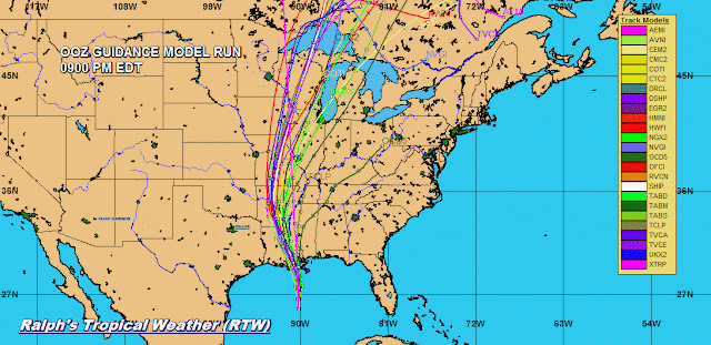
Thursday, June 11, 2020

STORM INVESTIGATION ATLANTIC

NHC IS MONITORING A WAVE THAT IS ASSOCIATED WITH A SMALL CLUSTER OF SHOWERS AND THUNDERSTORMS, A POSSIBLE WEAK LOW.   CHANCES FOR DEVELOPMENT ARE LOW AT THIS TIME DUE TO UPPER LEVEL EASTERLY WINDS FROM THE CARIBBEAN AND SAHARA DRY AIR AND DUST TRAVELING WEST WITH THIS WAVE.  AS THIS CLUSTER MOVES OVER THE WINDWARD ISLANDS THIS EVENING SQUALLY CONDITIONS WITH BRIEF HEAVY DOWNPOURS COULD AFFECT THE AREA.
RTW

ZCZC MIATWOAT ALL
TTAA00 KNHC DDHHMM

Tropical Weather Outlook
NWS National Hurricane Center Miami FL
800 AM EDT Thu Jun 11 2020

For the North Atlantic...Caribbean Sea and the Gulf of Mexico:

1. A well-defined tropical wave located about 275 miles east of the 
Windward Islands continues to produce disorganized showers and 
thunderstorms.  Although significant development is not anticipated
due to inhibiting environmental conditions, some areas of heavy 
rain and gusty winds are possible across portions of the Windward 
Islands later today through early Friday while the wave moves 
westward at 15 to 20 mph.
* Formation chance through 48 hours...low...10 percent.
* Formation chance through 5 days...low...10 percent.

Forecaster Roberts


Wednesday, June 10, 2020

RTW TROPICAL WEATHER OUTLOOK

RTW TROPICAL WEATHER OUTLOOK

1.  A WESTWARD MOVING TROPICAL WEAVE NEAR 36°/35° IS MOVING THROUGH A PARTIAL AREA OF SAHARA DUST AND DRY AIR.  THE SHOWERS ALONG THE SOUTHERN AXIS OF THIS WAVE ARE MAINLY ASSOCIATED WITH THE INTERACTION ITCZ (INTER-TROPICAL CONVERGENCE ZONE).

2.  A WESTWARD MOVING TROPICAL WAVE NEAR 54°/53° HAS A SMALL CLUSTER OF SHOWERS AND STORMS ALONG THE NORTHERN AXIS OF THE WAVE.  THERE ARE NO SIGNS OF DEVELOPMENT.

3.  A WESTWARD MOVING WAVE NEAR 67°/66° HAS SHOWERS AND STORMS ALONG THE SOUTHERN AXIS OF THE WAVE MAINLY ASSOCIATED WITH MONSOONAL TROUGH IN THIS AREA.

4.  A WESTWARD MOVING TROPICAL WAVE NEAR 86°/85° HAS SHOWERS AND STORMS ON BOTH SIDES OF THE SOUTHERN ALSO ASSOCIATED WITH A MONSOON TROUGH IN THIS AREA.

NON OF THESE TROPICAL WAVES ARE SHOWING SIGNS OF ORGANIZATION AT THIS TIME.

RTW


Tuesday, June 9, 2020

RTW TROPICAL WEATHER OUTLOOK

RTW TROPICAL WEATHER OUTLOOK

1.  A WESTWARD MOVING TROPICAL WAVE NEAR 31°/30° WEST IS VOID OF ANY THUNDERSTORMS.  THE ONLY SHOWERS IS TO THE SOUTH ALONG THE SOUTHERN AXIS OF THE WAY ALONG THE ITZC INTER-TROPICAL CONVERGENCE ZONE.

2.  A WESTWARD MOVING TROPICAL WAVE NEAR 49°/48° WEST DOES HAVE SHOWERS AND STORMS AHEAD AND ALONG THE WAVES AXIS ALSO ASSOCIATED WITH THE  ITCZ.

3.  A WESTWARD MOVING TROPICAL WAVE NEAR 63° WEST IS VOID OF ANY SHOWERS OR THUNDERSTORMS.

4.  A WESTWARD MOVING TROPICAL WAVE NEAR 81°/77° WEST HAS STRONG THUNDERSTORMS ALONG THE SOUTHERN AXIS WHICH EXTENDS INTO THE EAST PACIFIC.  THIS THUNDERSTORM ACTIVITY IS RELATED TO THE INTERACTION WITH THIS WAVE A A MONSOON TROUGH IS THIS AREA.

THERE ARE NO SIGNS OF TROPICAL CYCLONE FORMATION AT THIS TIME.


Sunday, June 7, 2020

CRISTOBAL 0700 CDT UPDATE


000
WTNT33 KNHC 072352
TCPAT3

BULLETIN
Tropical Storm Cristobal Intermediate Advisory Number 25A
NWS National Hurricane Center Miami FL       AL032020
700 PM CDT Sun Jun 07 2020

...TROPICAL-STORM-FORCE WINDS CONTINUE ALONG THE GULF COAST FROM
SOUTHEASTERN LOUISIANA EASTWARD TO MISSISSIPPI AND ALABAMA...
...HEAVY RAINFALL AND STORM SURGE TO CONTINUE FROM SOUTHEASTERN
LOUISIANA EASTWARD TO THE FLORIDA PANHANDLE...


SUMMARY OF 700 PM CDT...0000 UTC...INFORMATION
----------------------------------------------
LOCATION...29.6N 89.8W
ABOUT 35 MI...55 KM SSE OF NEW ORLEANS LOUISIANA
MAXIMUM SUSTAINED WINDS...50 MPH...85 KM/H
PRESENT MOVEMENT...N OR 355 DEGREES AT 7 MPH...11 KM/H
MINIMUM CENTRAL PRESSURE...993 MB...29.32 INCHES


WATCHES AND WARNINGS
--------------------
CHANGES WITH THIS ADVISORY:

The Storm Surge Watch along the coast of Louisiana from east of
Morgan City to the mouth of the Mississippi River has been
discontinued.

The Tropical Storm Warning west of Morgan City Louisiana has been
discontinued.

SUMMARY OF WATCHES AND WARNINGS IN EFFECT:

A Storm Surge Warning is in effect for...
* Mouth of the Mississippi River to Ocean Springs Mississippi
* Lake Borgne

A Tropical Storm Warning is in effect for...
* Morgan City Louisiana to the Okaloosa/Walton County Florida line
* Lake Pontchartrain and Lake Maurepas

A Storm Surge Warning means there is a danger of life-threatening
inundation, from rising water moving inland from the coastline. For
a depiction of areas at risk, please see the National Weather
Service Storm Surge Watch/Warning Graphic, available at
hurricanes.gov.  This is a life-threatening situation.  Persons
located within these areas should take all necessary actions to
protect life and property from rising water and the potential for
other dangerous conditions. Promptly follow evacuation and other
instructions from local officials.

A Tropical Storm Warning means that tropical storm conditions are
expected somewhere within the warning area.

For storm information specific to your area, including possible
inland watches and warnings, please monitor products issued by your
local National Weather Service forecast office.


DISCUSSION AND OUTLOOK
----------------------
At 700 PM CDT (0000 UTC), the center of Tropical Storm Cristobal was
located near latitude 29.6 North, longitude 89.8 West. Cristobal is
moving toward the north near 7 mph (11 km/h).  A turn toward the
north-northwest is expected later this evening and tonight, followed
by a northward motion Monday night and Tuesday.  On the forecast
track, the center of Cristobal will move inland across southeastern
Louisiana through Monday morning, and northward across Arkansas and
Missouri Monday afternoon into Tuesday.

Maximum sustained winds remain near 50 mph (85 km/h) with higher
gusts.  Gradual weakening will begin overnight, and Cristobal is
forecast to weaken to a tropical depression on Monday.

Tropical-storm-force winds extend outward up to 205 miles (335 km)
from the center.  A NOAA automated observing station on Dauphin
Island, Alabama, recently reported a sustained wind of 45 mph (72
km/h) and a gust to 49 mph (80 km/h), and a Weatherflow site on Ship
Island, Mississippi, observed a sustained wind of 37 mph (59 km/h)
and a gust to 46 mph (74 km/h).

The estimated minimum central pressure based on nearby surface
observations is 993 mb (29.32 inches).


HAZARDS AFFECTING LAND
----------------------
Key messages for Cristobal can be found in the Tropical Cyclone
Discussion under AWIPS header MIATCDAT3, WMO header WTNT43 KNHC, and
on the web at www.hurricanes.gov/text/MIATCDAT3.shtml

STORM SURGE:  The combination of a dangerous storm surge and the
tide will cause normally dry areas near the coast to be flooded by
rising waters moving inland from the shoreline.  The water could
reach the following heights above ground somewhere in the indicated
areas if the peak surge occurs at the time of high tide...

Mouth of the Mississippi River to Ocean Springs MS including Lake
Borgne...3-5 ft
Morgan City LA to Mouth of the Mississippi River...1-3 ft
Ocean Springs MS to Marco Island FL including Mobile Bay, Pensacola
Bay, and Tampa Bay...1-3 ft

The deepest water will occur along the immediate coast in areas of
onshore winds and will likely extend along the coast well to the
east of the center.  Surge-related flooding depends on the relative
timing of the surge and the tidal cycle, and can vary greatly over
short distances.  For information specific to your area, please see
products issued by your local National Weather Service forecast
office.

WIND: Tropical storm conditions are expected within the Tropical
Storm Warning area along the northern Gulf coast through tonight.

RAINFALL:  Cristobal is expected to produce storm total rainfall
accumulations of 5 to 10 inches across portions of the central to
eastern Gulf Coast into the Lower Mississippi Valley, with isolated
amounts to 15 inches.  Rainfall totals of 2 to 4 inches with
local amounts to 6 inches are expected across portions of the Mid to
Upper Mississippi Valley and Northern Plains near and in advance of
Cristobal.  This rainfall will likely lead to flash flooding and
widespread flooding on smaller streams across portions of the
central Gulf Coast into the Lower Mississippi Valley.  New and
renewed significant river flooding is possible along the central
Gulf Coast and into the Mississippi Valley.

TORNADOES: A few tornadoes are possible tonight across eastern
Louisiana, southern Mississippi, southern Alabama, and northern
Florida.

SURF:  Swells generated by Cristobal will affect portions of the
northern and eastern Gulf coast during the next couple of days.
These swells are likely to cause life-threatening surf and rip
current conditions.  Please consult products from your local
weather office.


NEXT ADVISORY
-------------
Next complete advisory at 1000 PM CDT.

$$
Forecaster Brown/Latto


 LIVE RADAR
Local Radar

TROPICAL STORM CRISTOBAL UPDATE 1000 AM EDT

000
WTNT33 KNHC 071447
TCPAT3

BULLETIN
Tropical Storm Cristobal Advisory Number  24
NWS National Hurricane Center Miami FL       AL032020
1000 AM CDT Sun Jun 07 2020

...CRISTOBAL MOVING CLOSER TO SOUTHEASTERN LOUISIANA...
...HEAVY RAINFALL AND STORM SURGE EXPECTED FROM SOUTHEASTERN
LOUISIANA EASTWARD TO THE FLORIDA PANHANDLE...


SUMMARY OF 1000 AM CDT...1500 UTC...INFORMATION
-----------------------------------------------
LOCATION...28.7N 90.0W
ABOUT 90 MI...145 KM S OF NEW ORLEANS LOUISIANA
MAXIMUM SUSTAINED WINDS...50 MPH...85 KM/H
PRESENT MOVEMENT...N OR 355 DEGREES AT 12 MPH...19 KM/H
MINIMUM CENTRAL PRESSURE...994 MB...29.36 INCHES


WATCHES AND WARNINGS
--------------------
CHANGES WITH THIS ADVISORY:

None.

SUMMARY OF WATCHES AND WARNINGS IN EFFECT:

A Storm Surge Warning is in effect for...
* Mouth of the Mississippi River to Ocean Springs Mississippi
* Lake Borgne

A Storm Surge Watch is in effect for...
* East of Morgan City Louisiana to the mouth of the Mississippi
River

A Tropical Storm Warning is in effect for...
* Intracoastal City Louisiana to the Okaloosa/Walton County
Florida line
* Lake Pontchartrain and Lake Maurepas

A Storm Surge Warning means there is a danger of life-threatening
inundation, from rising water moving inland from the coastline,
during the next 36 hours in the indicated locations. For a depiction
of areas at risk, please see the National Weather Service Storm
Surge Watch/Warning Graphic, available at hurricanes.gov.  This is a
life-threatening situation.  Persons located within these areas
should take all necessary actions to protect life and property from
rising water and the potential for other dangerous conditions.
Promptly follow evacuation and other instructions from local
officials.

A Storm Surge Watch means there is a possibility of life-
threatening inundation, from rising water moving inland from the
coastline, in the indicated locations during the next 48 hours.

A Tropical Storm Warning means that tropical storm conditions are
expected somewhere within the warning area within the next 24 hours.

For storm information specific to your area, including possible
inland watches and warnings, please monitor products issued by your
local National Weather Service forecast office.


DISCUSSION AND OUTLOOK
----------------------
At 1000 AM CDT (1500 UTC), the center of Tropical Storm Cristobal 
was located near latitude 28.7 North, longitude 90.0 West. Cristobal 
is moving toward the north near 12 mph (19 km/h), and this general 
motion is expected to continue today, followed by a gradual turn 
toward the north-northwest late today or tonight.  On the forecast 
track, the center of Cristobal will approach the northern Gulf of 
Mexico coast this afternoon, then move inland across Louisiana late 
today through Monday morning, and northward across Arkansas and 
Missouri Monday afternoon into Tuesday.

Data from an Air Force Reserve reconnaissance aircraft and NOAA 
Doppler weather radars indicate that maximum sustained winds remain 
near 50 mph (85 km/h) with higher gusts. Little change in strength 
is forecast before landfall. Gradual weakening will begin once 
Cristobal moves inland.

Tropical-storm-force winds extend outward up to 205 miles (335 km),
mainly to the east of the center.  A Weatherflow site at Bayou 
Bienvenue, Louisiana, recently measured a sustained wind of 37 mph 
(60 km/h) and a gust to 47 mph (76 km/h).

The estimated minimum central pressure is 994 mb (29.36 inches).


HAZARDS AFFECTING LAND
----------------------
Key messages for Cristobal can be found in the Tropical Cyclone
Discussion under AWIPS header MIATCDAT3, WMO header WTNT43 KNHC, and
on the web at www.hurricanes.gov/text/MIATCDAT3.shtml

STORM SURGE:  The combination of a dangerous storm surge and the
tide will cause normally dry areas near the coast to be flooded by
rising waters moving inland from the shoreline.  The water could
reach the following heights above ground somewhere in the indicated
areas if the peak surge occurs at the time of high tide...

Mouth of the Mississippi River to Ocean Springs MS including Lake
Borgne...3-5 ft
Morgan City LA to Mouth of the Mississippi River...2-4 ft
Ocean Springs MS to Marco Island FL including Mobile Bay, Pensacola
Bay, and Tampa Bay...1-3 ft

The deepest water will occur along the immediate coast in areas of
onshore winds and will likely extend along the coast well to the
east of the center.  Surge-related flooding depends on the relative
timing of the surge and the tidal cycle, and can vary greatly over
short distances.  For information specific to your area, please see
products issued by your local National Weather Service forecast
office.

WIND: Tropical storm conditions are expected within the Tropical
Storm Warning area along the northern Gulf coast through tonight.

RAINFALL: Cristobal is expected to produce total rainfall 
accumulations of 4 to 8 inches across portions of the central Gulf 
Coast into the Lower Mississippi Valley, with isolated amounts to 
12 inches.  Rainfall totals of 2 to 4 inches with local amounts to 
6 inches are expected across portions of the eastern Gulf Coast, 
along with the Mid to Upper Mississippi Valley and Northern Plains 
near and in advance of Cristobal.  This rainfall will likely lead 
to flash flooding and widespread flooding on smaller streams across 
portions of the central Gulf Coast into the Lower Mississippi 
Valley.  New and renewed significant river flooding is possible 
along the central Gulf Coast and into the Mississippi Valley.

TORNADOES: A few tornadoes are possible today and tonight across
eastern Louisiana, southern Mississippi, southern Alabama, and
northern Florida.

SURF:  Swells generated by Cristobal will affect portions of the
northern and eastern Gulf coast during the next couple of days.
These swells are likely to cause life-threatening surf and rip
current conditions.  Please consult products from your local
weather office.


NEXT ADVISORY
-------------
Next intermediate advisory at 100 PM CDT.
Next complete advisory at 400 PM CDT.

$$
Forecaster Stewart 


Saturday, June 6, 2020

TROPICAL STORM CRISTOBAL UPDATE 1000 PM EDT

779 
WTNT33 KNHC 070241
TCPAT3

BULLETIN
Tropical Storm Cristobal Advisory Number  22
NWS National Hurricane Center Miami FL       AL032020
1000 PM CDT Sat Jun 06 2020

...OUTER RAINBANDS OF CRISTOBAL MOVING ACROSS PORTIONS OF THE
GULF COAST...
...CONDITIONS EXPECTED TO CONTINUE TO DETERIORATE...


SUMMARY OF 1000 PM CDT...0300 UTC...INFORMATION
-----------------------------------------------
LOCATION...26.2N 90.2W
ABOUT 210 MI...340 KM SSW OF THE MOUTH OF THE MISSISSIPPI RIVER
MAXIMUM SUSTAINED WINDS...50 MPH...85 KM/H
PRESENT MOVEMENT...N OR 360 DEGREES AT 12 MPH...19 KM/H
MINIMUM CENTRAL PRESSURE...993 MB...29.33 INCHES


WATCHES AND WARNINGS
--------------------
CHANGES WITH THIS ADVISORY:

None.

SUMMARY OF WATCHES AND WARNINGS IN EFFECT:

A Storm Surge Warning is in effect for...
* Mouth of the Mississippi River to Ocean Springs Mississippi
* Lake Borgne

A Storm Surge Watch is in effect for...
* East of Morgan City Louisiana to the mouth of the Mississippi
River

A Tropical Storm Warning is in effect for...
* Intracoastal City Louisiana to the Okaloosa/Walton County
Florida line
* Lake Pontchartrain and Lake Maurepas

A Storm Surge Warning means there is a danger of life-threatening
inundation, from rising water moving inland from the coastline,
during the next 36 hours in the indicated locations. For a depiction
of areas at risk, please see the National Weather Service Storm
Surge Watch/Warning Graphic, available at hurricanes.gov.  This is a
life-threatening situation.  Persons located within these areas
should take all necessary actions to protect life and property from
rising water and the potential for other dangerous conditions.
Promptly follow evacuation and other instructions from local
officials.

A Storm Surge Watch means there is a possibility of life-
threatening inundation, from rising water moving inland from the
coastline, in the indicated locations during the next 48 hours.

A Tropical Storm Warning means that tropical storm conditions are
expected somewhere within the warning area within the next 36 hours.

For storm information specific to your area, including possible
inland watches and warnings, please monitor products issued by your
local National Weather Service forecast office.


DISCUSSION AND OUTLOOK
----------------------
At 1000 PM CDT (0300 UTC), the center of Tropical Storm Cristobal
was located near latitude 26.2 North, longitude 90.2 West. Cristobal
is moving toward the north near 12 mph (19 km/h) and this general
motion is expected to continue for the next day or so, followed by a
gradual turn toward the north-northwest.  On the forecast track, the
center of Cristobal will be near the northern Gulf of Mexico
coast on Sunday.  Cristobal's center is then forecast to move
inland across Louisiana late Sunday through Monday morning, and
northward across Arkansas and Missouri Monday afternoon into
Tuesday.

Maximum sustained winds remain near 50 mph (85 km/h) with higher
gusts.  Some slow strengthening is forecast until landfall occurs on
the northern Gulf coast.  Weakening will begin once Cristobal moves
inland late Sunday and Monday.

Tropical-storm-force winds extend outward up to 240 miles (390 km)
from the center.

The minimum central pressure based on surface observations and data
from the NOAA and Air Force Hurricane Hunters is 993 mb (29.33
inches).


HAZARDS AFFECTING LAND
----------------------
Key messages for Cristobal can be found in the Tropical Cyclone
Discussion under AWIPS header MIATCDAT3, WMO header WTNT43 KNHC, and
on the web at www.hurricanes.gov/text/MIATCDAT3.shtml

STORM SURGE:  The combination of a dangerous storm surge and the
tide will cause normally dry areas near the coast to be flooded by
rising waters moving inland from the shoreline.  The water could
reach the following heights above ground somewhere in the indicated
areas if the peak surge occurs at the time of high tide...

Mouth of the Mississippi River to Ocean Springs MS including Lake
Borgne...3-5 ft
Morgan City LA to Mouth of the Mississippi River...2-4 ft
Ocean Springs MS to Marco Island FL including Mobile Bay, Pensacola
Bay, and Tampa Bay...1-3 ft

The deepest water will occur along the immediate coast in areas of
onshore winds and will likely extend along the coast well to the
east of the center.  Surge-related flooding depends on the relative
timing of the surge and the tidal cycle, and can vary greatly over
short distances.  For information specific to your area, please see
products issued by your local National Weather Service forecast
office.

WIND: Tropical storm conditions are expected within the Tropical
Storm Warning area along the northern Gulf coast beginning Sunday
morning.

RAINFALL: Cristobal is expected to produce total rainfall
accumulations of 4 to 8 inches across the eastern and central Gulf
coast into the Lower Mississippi Valley, with isolated amounts to 12
inches.   Isolated significant river flooding is possible along the
central Gulf coast.  Rainfall totals of 2 to 4 inches, with local
amounts to 6 inches, are expected across portions of the Mid and
Upper Mississippi Valley and Northern Plains near and in advance of
Cristobal.  This rainfall may lead to flash flooding and widespread
flooding on smaller streams across the Mid-Mississippi Valley.

TORNADOES: A few tornadoes will be possible overnight into Sunday
morning from Florida westward across the central Gulf coast region.

SURF:  Swells generated by Cristobal will affect portions of the
northern and eastern Gulf coast during the next couple of days.
These swells are likely to cause life-threatening surf and rip
current conditions.  Please consult products from your local
weather office.


NEXT ADVISORY
-------------
Next intermediate advisory at 100 AM CDT.
Next complete advisory at 400 AM CDT.

$$
Forecaster Cangialosi/Latto