Tuesday, June 3, 2025

AWAY CELEBRATING OUR 45TH ANNIVERSARY!


I will do brief updates from phone or laptop when possible.

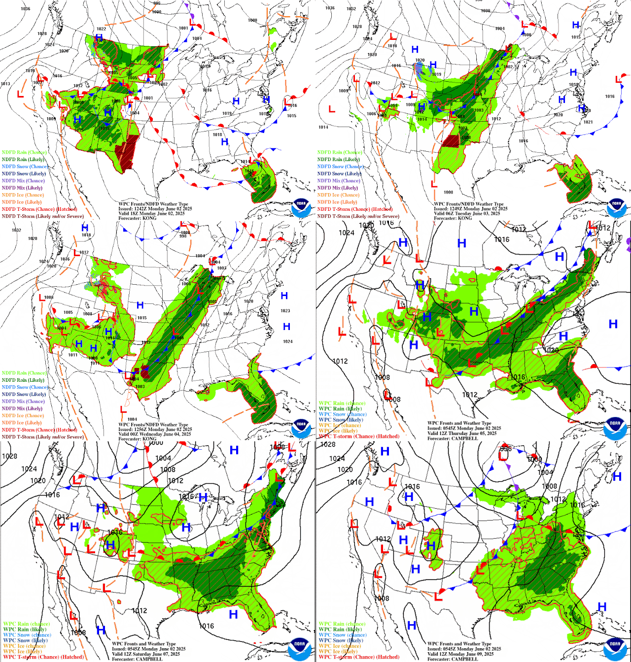
Flood watch is in effect


Monday, June 2, 2025

NHC IS NOW MONITORING A NON-TROPICAL LOW OFF THE SOUTHEAST COAST.. ..NOT RELATED WITH THE TROPICS BUT HEAVYS RAINS EXPECTED TODAY AND TOMORROW.


The National Hurricane Center has posted an investigation for a non-tropical low off the southeast U.S. coast. See below for the latest. 

I do have to mention heavy rainfall is possible for today and tomorrow due to a stalled frontal boundary north of Lake Okeechobee. This boundary is enhancing storms on the Gulf and Atlantic sides over the Bahamas and over a portion of Florida today and tomorrow. Some showers and storms could be severe at times with heavy rains that can produce localized flooding in poor drainage areas. This will begin later this afternoon and into the evening hours. Please don't drive through flooded roads that seem to be too deep. If you're not sure, "turn around and don't drown!"

RTW

000
ABNT20 KNHC 021721
TWOAT 

Tropical Weather Outlook
NWS National Hurricane Center Miami FL
200 PM EDT Mon Jun 2 2025

For the North Atlantic...Caribbean Sea and the Gulf of America:

Offshore of the Southeastern U.S. Coast
A non-tropical area of low pressure is forecast to form near or 
offshore of the southeastern U.S. coast during the next couple of 
days. If the system remains offshore, the low could gradually 
develop some subtropical or tropical characteristics later this 
week while moving northeastward at 10 to 15 mph.
* Formation chance through 48 hours...low...near 0 percent.
* Formation chance through 7 days...low...10 percent.

$$
Forecaster Reinhart
----------------------------------------------------------------
720 
ACCA62 KNHC 021723
TWOSAT

Perspectiva del Tiempo Tropical
Centro Nacional de Huracanes del SNM Miami FL
200 PM EDT lunes 2 de junio de 2025

Para el Atlántico Norte...Mar Caribe y el Golfo de América:

Mar adentro de la costa sureste de los Estados Unidos Se pronostica
que un área no tropical de baja presión se formará cerca o en alta
mar de la costa sureste de los Estados Unidos durante los próximos
dos días. Si el sistema permanece en alta mar, la baja podría
desarrollar gradualmente algunas características subtropicales o
tropicales más tarde esta semana mientras se mueve hacia el noreste
a 10 a 15 mph.
* Probabilidad de formación hasta 48 horas...baja...cerca del 0 por
ciento.
* Probabilidad de formación hasta 7 días...baja...10 por ciento.

$$
Pronosticador Reinhart

*** Este producto ha sido procesado automáticamente utilizando un
programa de traducción y puede contener omisiones y errores. El
Servicio Nacional de Meteorología no puede garantizar la precisión
del texto convertido. De haber alguna duda, el texto en inglés es
siempre la versión autorizada. ***


Sunday, June 1, 2025

STILL MONITORING THE MODELS FOR DEVELOPMENT DURING MID JUNE!


The tropics remain quiet for now, but all indicators are suggesting that it will be another busy hurricane season. So we need to enter this season prepared and ready for whatever Mother Nature sends our way. Being that we live in the path of these storms, eventually one will come our way, and not being ready will make it much more difficult to recover quickly. Get to know your neighbors and make plans in the event a disaster strikes our area. Learn first aid and CPR/AED and how to triage an injured victim. There are CERT (Community Emergency Response Team) classes that will teach disaster first aid and triage. Call your local fire department and ask them if they offer these classes. There usually are three classes, but some are finishing them up in two days. I am not liking the idea of entering this season not being prepared. We are not immune to hurricanes, so don't become complacent. LET'S BE STORM READY!

National Hurricane Center

479 
ABNT20 KNHC 012321
TWOAT 

Tropical Weather Outlook
NWS National Hurricane Center Miami FL
800 PM EDT Sun Jun 1 2025

For the North Atlantic...Caribbean Sea and the Gulf of America:

Tropical cyclone formation is not expected during the next 7 days.

$$
Forecaster Kelly
------------------------------------------------------------------
103 
ACCA62 KNHC 012322
TWOSAT

Perspectiva del Tiempo Tropical
Centro Nacional de Huracanes del SNM Miami FL
800 PM EDT domingo 1 de junio de 2025

Para el Atlántico Norte...Mar Caribe y el Golfo de América:

No se espera la formación de ciclones tropicales durante los
próximos 7 días.

$$
Pronosticador Kelly

*** Este producto ha sido procesado automáticamente utilizando un
programa de traducción y puede contener omisiones y errores. El
Servicio Nacional de Meteorología no puede garantizar la precisión
del texto convertido. De haber alguna duda, el texto en inglés es
siempre la versión autorizada. ***


Friday, May 30, 2025

MIDDLE OF JUNE THE EURO AND THE AMERICAN ENSEMBLE MODELS CONTINUES TO SHOW DEVELOPMENT!


Well, so far two of the ensemble models, the American and the Euro, continue to hint at development in the middle of June, between June 11 and 18. I will continue to monitor for any tropical cyclone formation during that time.

RTW


National Hurricane Center

000
ABNT20 KNHC 301128
TWOAT 

Tropical Weather Outlook
NWS National Hurricane Center Miami FL
800 AM EDT Fri May 30 2025

For the North Atlantic...Caribbean Sea and the Gulf of America:

Tropical cyclone formation is not expected during the next 7 days. 

$$
Forecaster Hagen
------------------------------------------------------------------
066 
ACCA62 KNHC 301129
TWOSAT

Perspectiva del Tiempo Tropical
Centro Nacional de Huracanes del SNM Miami FL
800 AM EDT viernes 30 de mayo de 2025

Para el Atlántico Norte...Mar Caribe y el Golfo de América:

No se espera la formación de ciclones tropicales durante los
próximos 7 días.

$$
Pronosticador Hagen

*** Este producto ha sido procesado automáticamente utilizando un
programa de traducción y puede contener omisiones y errores. El
Servicio Nacional de Meteorología no puede garantizar la precisión
del texto convertido. De haber alguna duda, el texto en inglés es
siempre la versión autorizada. ***

UPPER LEVEL CONDITIONS ARE NOT FAVORABLE IN THE
CARRIBAN OR THE GULF OF AMERICA AT THIS TIME


DRY AIR IS IN THE ORANGE REDS AND MAROON COLORS.
THE DARKER THE DRYER IT IS IN THE UPPER LEVELS


Thursday, May 29, 2025

TROPICS REMAIN QUIET MAY 29, 2025


All remains quiet!
A guide for generator maintenance or consult your owner's manual. 

Generator Maintenance

National Hurricane Center

793 
ABNT20 KNHC 291720
TWOAT 

Tropical Weather Outlook
NWS National Hurricane Center Miami FL
200 PM EDT Thu May 29 2025

For the North Atlantic...Caribbean Sea and the Gulf of America:

Tropical cyclone formation is not expected during the next 7 days. 

$$
Forecaster Kelly
-----------------------------------------------------------------
203 
ACCA62 KNHC 291720
TWOSAT

Perspectiva del Tiempo Tropical
Centro Nacional de Huracanes del SNM Miami FL
200 PM EDT jueves 29 de mayo de 2025

Para el Atlántico Norte...Mar Caribe y el Golfo de América:

No se espera la formación de ciclones tropicales durante los
próximos 7 días.

$$
Pronosticador Kelly

*** Este producto ha sido procesado automáticamente utilizando un
programa de traducción y puede contener omisiones y errores. El
Servicio Nacional de Meteorología no puede garantizar la precisión
del texto convertido. De haber alguna duda, el texto en inglés es
siempre la versión autorizada. ***

ENSEMBLE STILL SHOWING SOMETHING COMING UP FROM THE CARIBBEAN.


GREATER THAN 20% CHANCE FOR DEVELOPMENT
IN THE BOC OR THE NORTHWEST CARIBBEAN
BETWEEN JUNE 11-17.


Wednesday, May 28, 2025

THE TROPICS REMAIN QUIET BUT WE COULD SEE SOME DEVELOPMENT MID JUNE!


All remains quiet in the tropics for now, but the forecast is hinting at possible development in the northwest Caribbean or the Bay of Campeche (BOC) by the middle of June. I will keep monitoring and will let you know.

RTW


THE ENSEMBLE MODELS ALSO HINTING AT 
POSSIBLE DEVELOPMENT MID JUNE.


NATIONAL HURRICANE CENTER

000
ABNT20 KNHC 281125
TWOAT 

Tropical Weather Outlook
NWS National Hurricane Center Miami FL
800 AM EDT Wed May 28 2025

For the North Atlantic...Caribbean Sea and the Gulf of America:

Tropical cyclone formation is not expected during the next 7 days. 

$$
Forecaster Kelly/Mora
------------------------------------------------------------------
692 
ACCA62 KNHC 281126
TWOSAT

Perspectiva del Tiempo Tropical
Centro Nacional de Huracanes del SNM Miami FL
800 AM EDT miércoles 28 de mayo de 2025

Para el Atlántico Norte...Mar Caribe y el Golfo de América:

No se espera la formación de ciclones tropicales durante los
próximos 7 días.

$$
Pronosticador Kelly/Mora

*** Este producto ha sido procesado automáticamente utilizando un
programa de traducción y puede contener omisiones y errores. El
Servicio Nacional de Meteorología no puede garantizar la precisión
del texto convertido. De haber alguna duda, el texto en inglés es
siempre la versión autorizada. ***

SAHARA DUST AND DRY AIR OVER THE ATLANTIC AND THE
CARIBBEAN AND EVENTUALLY IN THE GULF OF AMERICA

DRY AIR SEEN IN THE ORANGE DARK MAROON COLORS. UPPER LEVEL LOW
SEEN ON WATER VAPOR SATELLITE TRACKING WEST BETWEEN CUBA AND HAITI.

UPPER-LEVEL WIND SHEAR IS UNFAVORABLE THROUGHOUT THE
TROPICS EXCEPT FOR EAST OF FLORIDA AND THE BAHAMAS
AND SOUTH OF 10°NORTH SOUTH CENTRAL ATLANTIC.