Friday, January 20, 2017

SEVERE THUNDERSTORM WARNING LOUISIANA
420
WUUS54 KLCH 210426
SVRLCH
LAC001-003-039-053-210500-
/O.NEW.KLCH.SV.W.0017.170121T0426Z-170121T0500Z/
BULLETIN - IMMEDIATE BROADCAST REQUESTED
Severe Thunderstorm Warning
National Weather Service Lake Charles LA
1026 PM CST FRI JAN 20 2017
The National Weather Service in Lake Charles has issued a
* Severe Thunderstorm Warning for...
Northeastern Jefferson Davis Parish in southwestern Louisiana...
Southwestern Evangeline Parish in central Louisiana...
Northwestern Acadia Parish in southwestern Louisiana...
Allen Parish in southwestern Louisiana...
* Until 1100 PM CST
* At 1026 PM CST, a severe thunderstorm was located near Kinder,
moving east at 45 mph.
HAZARD...70 mph wind gusts and quarter size hail.
SOURCE...Radar indicated.
IMPACT...Hail damage to vehicles is expected. Expect considerable
tree damage. Wind damage is also likely to mobile homes,
roofs, and outbuildings.
* Locations impacted include...
Eunice, Oakdale, Kinder, Basile, Oberlin, Elton, Mittie, Harmony,
Duralde, Allen Parish Airport, Leblanc, Beaver and Bond.
PRECAUTIONARY/PREPAREDNESS ACTIONS...
For your protection move to an interior room on the lowest floor of a
building.
&&
A tornado watch remains in effect until 200 AM CST for central and
southwestern Louisiana.
LAT...LON 3089 9261 3053 9244 3052 9246 3050 9246
3048 9249 3048 9242 3046 9241 3044 9298
3060 9299 3060 9298 3070 9298
TIME...MOT...LOC 0426Z 250DEG 40KT 3053 9287
HAIL...1.00IN
WIND...70MPH


LOW BAROMETRIC PRESSURE FOR THIS FORECAST LOW PRESSURE SYSTEM
Ryan Maue
@RyanMaue
3 minutes ago


Your barometer in N Georgia and Carolinas may see lowest pressure for non-tropical Low (973 mb) in a generation.


WEST COAST BEING HAMMERED BY A STRONG PACIFIC STORM SYSTEM
STRONG GUSTY WINDS, HEAVY RAINS!
Chula Vista Police @ChulaVistaPD
1 hour ago

Chula Vista Police
Chula Vista Police asks the public to avoid driving tonight. The City is experiencing multiple traffic hazards and power outages

TORNADO WARNING LAKE CHARLES LA

WFUS54 KLCH 210256
TORLCH
LAC011-019-210330-
/O.NEW.KLCH.TO.W.0008.170121T0256Z-170121T0330Z/
BULLETIN - EAS ACTIVATION REQUESTED
Tornado Warning
National Weather Service Lake Charles LA
856 PM CST FRI JAN 20 2017
The National Weather Service in Lake Charles has issued a
* Tornado Warning for...
South central Beauregard Parish in southwestern Louisiana...
Northwestern Calcasieu Parish in southwestern Louisiana...
* Until 930 PM CST
* At 856 PM CST, a severe thunderstorm capable of producing a tornado
was located over Starks, moving northeast at 45 mph.
HAZARD...Tornado and quarter size hail.
SOURCE...Radar indicated rotation.
IMPACT...Flying debris will be dangerous to those caught without
shelter. Mobile homes will be damaged or destroyed.
Damage to roofs, windows, and vehicles will occur. Tree
damage is likely.
* This dangerous storm will be near...
Lunita around 905 PM CST.
De Quincy, Dequincy, Oretta and Buhler around 920 PM CST.
PRECAUTIONARY/PREPAREDNESS ACTIONS...
TAKE COVER NOW! Move to an interior room on the lowest floor of a
sturdy building. Avoid windows. If you are outdoors, in a mobile
home, or in a vehicle, move to the closest substantial shelter and
protect yourself from flying debris.
&&
LAT...LON 3037 9376 3055 9343 3028 9332 3020 9370
3023 9371 3029 9371 3030 9374 3036 9376
3036 9375
TIME...MOT...LOC 0256Z 243DEG 37KT 3032 9367
TORNADO...RADAR INDICATED
HAIL...1.00IN
$$
24


TORNADO WATCH AREA

 URGENT - IMMEDIATE BROADCAST REQUESTED
   Tornado Watch Number 9
   NWS Storm Prediction Center Norman OK
   720 PM CST Fri Jan 20 2017

   The NWS Storm Prediction Center has issued a

   * Tornado Watch for portions of
     Southwestern and south-central Louisiana
     Extreme southeast Texas
     Coastal Waters

   * Effective this Friday night and Saturday morning from 720 PM
     until 200 AM CST.

   * Primary threats include...
     A few tornadoes possible
     Scattered damaging wind gusts to 70 mph possible
     Isolated very large hail events to 2.5 inches in diameter
       possible

   SUMMARY...A cluster of thunderstorms over southeast Texas appears to
   be the start of a more expansive overnight severe-storm event moving
   east-northeastward through this watch (and eventually beyond).
   Additional, more isolated severe storms also may form ahead of the
   main complex, along and south of a returning marine/warm frontal
   zone.  The tornado threat, while marginal at first, will increase
   with time and with eastward extent across the watch area tonight,
   into southern Louisiana, as shear and instability increase.

   The tornado watch area is approximately along and 50 statute miles
   north and south of a line from 20 miles southwest of Port Arthur TX
   to 25 miles northeast of Lafayette LA. For a complete depiction of
   the watch see the associated watch outline update (WOUS64 KWNS
   WOU9).

   PRECAUTIONARY/PREPAREDNESS ACTIONS...

   REMEMBER...A Tornado Watch means conditions are favorable for
   tornadoes and severe thunderstorms in and close to the watch
   area. Persons in these areas should be on the lookout for
   threatening weather conditions and listen for later statements
   and possible warnings.

   &&

   AVIATION...Tornadoes and a few severe thunderstorms with hail
   surface and aloft to 2.5 inches. Extreme turbulence and surface wind
   gusts to 60 knots. A few cumulonimbi with maximum tops to 450. Mean
   storm motion vector 25030.

   ...Edwards

TORNADO WARNING IN TEXAS
WFUS54 KLCH 210232
TORLCH
LAC019-TXC241-351-361-210300-
/O.NEW.KLCH.TO.W.0007.170121T0232Z-170121T0300Z/
BULLETIN - EAS ACTIVATION REQUESTED
Tornado Warning
National Weather Service Lake Charles LA
832 PM CST FRI JAN 20 2017
The National Weather Service in Lake Charles has issued a
* Tornado Warning for...
West central Calcasieu Parish in southwestern Louisiana...
Southwestern Newton County in southeastern Texas...
Northeastern Orange County in southeastern Texas...
Southeastern Jasper County in southeastern Texas...
* Until 900 PM CST
* At 832 PM CST, a severe thunderstorm capable of producing a tornado
was located near Mauriceville, moving northeast at 35 mph.
HAZARD...Tornado and quarter size hail.
SOURCE...Radar indicated rotation.
IMPACT...Flying debris will be dangerous to those caught without
shelter. Mobile homes will be damaged or destroyed.
Damage to roofs, windows, and vehicles will occur. Tree
damage is likely.
* This dangerous storm will be near...
Mauriceville and Gist around 840 PM CST.
Hartburg and Forest Heights around 850 PM CST.
Deweyville around 855 PM CST.
Starks around 900 PM CST.
PRECAUTIONARY/PREPAREDNESS ACTIONS...
TAKE COVER NOW! Move to an interior room on the lowest floor of a
sturdy building. Avoid windows. If you are outdoors, in a mobile
home, or in a vehicle, move to the closest substantial shelter and
protect yourself from flying debris.
&&
LAT...LON 3025 9405 3045 9375 3042 9373 3041 9373
3040 9374 3040 9371 3022 9357 3009 9395
TIME...MOT...LOC 0232Z 240DEG 29KT 3021 9393
TORNADO...RADAR INDICATED
HAIL...1.00IN
$$
24


SEVERE THUNDERSTORM OUTLOOK FOR THIS EVENING
AccuWeather
@breakingweather
49 minutes ago

Severe thunderstorms will develop across the southeastern US tonight and may produce a few tornadoes. http://ow.ly/RxV6308d6Hs

HAZARDOUS WEATHER OUTLOOK

Hazardous Weather Outlook Text
FLUS42 KMFL 202343
HWOMFL

HAZARDOUS WEATHER OUTLOOK FOR SOUTH FLORIDA
NATIONAL WEATHER SERVICE MIAMI FL
643 PM EST FRI JAN 20 2017

AMZ610-630-650-651-670-671-FLZ063-066>075-168-172>174-GMZ656-657-676-
211145-
LAKE OKEECHOBEE-BISCAYNE BAY-
COASTAL WATERS FROM JUPITER INLET TO DEERFIELD BEACH FL OUT 20 NM-
COASTAL WATERS FROM DEERFIELD BEACH TO OCEAN REEF FL OUT 20 NM-
WATERS FROM JUPITER INLET TO DEERFIELD BEACH FL FROM 20 TO 60 NM-
WATERS FROM DEERFIELD BEACH TO OCEAN REEF FL FROM 20 TO 60 NM
EXCLUDING THE TERRITORIAL WATERS OF BAHAMAS-GLADES-HENDRY-
INLAND PALM BEACH-METRO PALM BEACH-COASTAL COLLIER-INLAND COLLIER-
INLAND BROWARD-METRO BROWARD-INLAND MIAMI-DADE-METRO MIAMI-DADE-
MAINLAND MONROE-COASTAL PALM BEACH-COASTAL BROWARD-COASTAL MIAMI-
DADE-FAR SOUTH MIAMI-DADE-
COASTAL WATERS FROM CHOKOLOSKEE TO BONITA BEACH FL OUT 20 NM-
COASTAL WATERS FROM EAST CAPE SABLE TO CHOKOLOSKEE FL OUT 20 NM-
WATERS FROM CHOKOLOSKEE TO BONITA BEACH FL FROM 20 TO 60 NM-
643 PM EST FRI JAN 20 2017

...STRONG THUNDERSTORMS POSSIBLE SUNDAY AFTERNOON INTO MONDAY...
...DETERIORATING MARINE CONDITIONS LATE THIS WEEKEND...

THIS HAZARDOUS WEATHER OUTLOOK IS FOR SOUTH FLORIDA.

.DAY ONE...TONIGHT

NO OTHER HAZARDOUS WEATHER IS EXPECTED AT THIS TIME.

.DAYS TWO THROUGH SEVEN...SATURDAY THROUGH THURSDAY

THUNDERSTORMS ARE POSSIBLE LATE SUNDAY INTO EARLY MONDAY AS A COLD
FRONT MOVES THROUGH SOUTH FLORIDA. SOME OF THESE THUNDERSTORMS MAY
BE STRONG TO SEVERE, WITH GUSTY WINDS, SMALL HAIL AND AN ISOLATED
TORNADO CAN NOT BE RULED OUT.

STRONG WEST AND SOUTHWEST WINDS ASSOCIATED WITH THIS FRONT WILL
INCREASE SEAS AND LEAD TO HAZARDOUS MARINE CONDITIONS ON SOUTH
FLORIDA WATERS SUNDAY THROUGH EARLY TUESDAY. IN ADDITION, RIP
CURRENTS, COASTAL FLOODING, AND BEACH EROSION ARE POSSIBLE ALONG
THE GULF COAST.

.SPOTTER INFORMATION STATEMENT...

SPOTTER ACTIVATION WILL NOT BE NEEDED.

FOR MORE INFORMATION...VISIT THE NATIONAL WEATHER SERVICE IN
MIAMI WEBSITE AT WWW.WEATHER.GOV/MIAMI.
SEVEN DAY MIAMI AND VICINITY FORECAST...UPDATED AT 0724 PM EST

Tonight Jan 20, 2017
Mostly Clear:
Lows around 63°F.
South southwest wind 5 to 10 MPH.
Saturday Jan 21
Partly Cloudy
during the day: Highs around 81°F due to a shift of the wind because of
approaching front. South wind 6 to 15 MPH.
Mostly Clear
during the night: Lows around 72°F. South wind to 13 MPH.
Sunday Jan 22
Partly cloudy
with isolated showers during the day: Highs around 82°F. Windy,
with a south southwest wind 11 to 24 MPH, gusting to
31 MPH. Chance of rain 20 percent.
Windy with rain showers during the night: Lows
around 68°F. South
southwest wind 19 to 26 MPH, gusting to 34 MPH. Chance of rain 80 percent.
Monday Jan 23
Partly cloudy
with scattered showers during the day: Highs around 75°F. Windy,
with a west wind to 25 MPH, gusting to 33 MPH.
Chance of rain 40 percent.
Mostly Clear during
the night: Lows around 59°F. Windy,
with a west wind 14 to 21 MPH, gusting to
26 MPH.
Tuesday Jan 24
Sunny during
the day: Highs around 75°F. West northwest wind 8 to 14 MPH.
Clear during
the night: Lows around 59°F. West
northwest wind to 7 MPH.
Wednesday Jan 25
Sunny during
the day: Highs around 79°F. Northeast wind 5 to 10 MPH.
Mostly Clear night:
Lows around 64°F.
South wind to 9 MPH.
Thursday Jan 26
Mostly Sunny
during the Day: Highs around 81°F. West southwest wind 5 to 10 MPH.
Partly Cloudy
during the night: Lows around 64°F. South
southwest wind to 10 MPH.
Friday Jan 27
Mostly Sunny
during the day: Highs around 77°F. West Northwest
wind to 12 MPH.
Partly Cloudy
during the night: Lows around 57°F.
Northwest wind to 10 MPH.


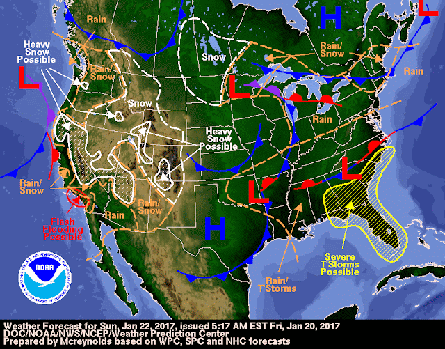
SOUTHEAST STAY ALERT FRIDAY NIFOR SEVERE STORMS AND FLOODING


FLORIDA BE ALERT SATURDAY TO SUNDAY FOR SEVERE STORMS AND FLOODING

LOCAL NEWS FORECAST FOR THIS WEEKEND
WPLG Local 10 News
@WPLGLocal10
2 minutes ago

There is a slight risk of severe weather for South Florida Sunday night into early Monday.


Subscribe to:
Posts (Atom)