Saturday, January 21, 2017

WEEKEND SEVERE WEATHER FORECAST FROM LOCAL MET
WSVN 7 News Retweeted
A front nears Sun night. Slight chance for strong storms for So FL, mod chance for Ctl FL. Cooler temps next week.

 Phil Ferro

HRES RAPID REFRESH MODEL SUGGESTING LONG SUPERCELL TRACK
Ryan Maue
@RyanMaue
1 hour ago


Previous 18-hr HRRR max wind gust tracks suggest long-lived supercell potential across central Alabama & Georgia. Can't know exactly tho


TORNADO WATCH AREA EXTENDED EASTWARD...
TORNADO WATCH AREA EXTENDED EASTWARD AND THERE ARE TWO TORNADO AVIATION WATCH BOX IN PINK.


ANOTHER TORNADO WARNING
651
WWUS54 KLIX 210531
SVSLIX
Severe Weather Statement
National Weather Service New Orleans LA
1131 PM CST FRI JAN 20 2017
LAC077-125-210545-
/O.CON.KLIX.TO.W.0004.000000T0000Z-170121T0545Z/
West Feliciana LA-Pointe Coupee LA-
1131 PM CST FRI JAN 20 2017
...A TORNADO WARNING REMAINS IN EFFECT UNTIL 1145 PM CST FOR NORTHERN
WEST FELICIANA AND NORTHWESTERN POINTE COUPEE PARISHES...
At 1130 PM CST, a severe thunderstorm capable of producing a tornado
was located near Lettsworth, or 11 miles east of Simmesport, moving
northeast at 45 mph.
HAZARD...Tornado and baseball size hail.
SOURCE...Radar indicated rotation.
IMPACT...Flying debris will be dangerous to those caught without
shelter. Mobile homes will be damaged or destroyed. Damage
to roofs, windows, and vehicles will occur. Tree damage is
likely.
Locations impacted include...
Batchelor and Lettsworth.
PRECAUTIONARY/PREPAREDNESS ACTIONS...
TAKE COVER NOW! Move to a basement or an interior room on the lowest
floor of a sturdy building. Avoid windows. If you are outdoors, in a
mobile home, or in a vehicle, move to the closest substantial shelter
and protect yourself from flying debris.
Tornadoes are extremely difficult to see and confirm at night. Do not
wait to see or hear the tornado. TAKE COVER NOW!
&&
LAT...LON 3087 9180 3098 9180 3099 9178 3100 9177
3104 9172 3104 9165 3097 9166 3100 9164
3100 9137 3096 9128 3070 9173 3074 9176
3078 9176 3081 9181 3084 9180 3086 9182
TIME...MOT...LOC 0530Z 227DEG 38KT 3093 9163
TORNADO...RADAR INDICATED
HAIL...2.75IN
$$
AK
======================================================================
129
WWUS54 KLIX 210526
SVSLIX
Severe Weather Statement
National Weather Service New Orleans LA
1126 PM CST FRI JAN 20 2017
LAC077-125-210545-
/O.CON.KLIX.TO.W.0004.000000T0000Z-170121T0545Z/
West Feliciana LA-Pointe Coupee LA-
1126 PM CST FRI JAN 20 2017
...A TORNADO WARNING REMAINS IN EFFECT UNTIL 1145 PM CST FOR NORTHERN
WEST FELICIANA AND NORTHWESTERN POINTE COUPEE PARISHES...
At 1126 PM CST, a severe thunderstorm capable of producing a tornado
was located near Lettsworth, or 10 miles northeast of Bayou Current,
moving northeast at 40 mph.
HAZARD...Tornado and golf ball size hail.
SOURCE...Radar indicated rotation.
IMPACT...Flying debris will be dangerous to those caught without
shelter. Mobile homes will be damaged or destroyed. Damage
to roofs, windows, and vehicles will occur. Tree damage is
likely.
This tornadic thunderstorm will remain over mainly rural areas of
northern West Feliciana and northwestern Pointe Coupee Parishes.
PRECAUTIONARY/PREPAREDNESS ACTIONS...
TAKE COVER NOW! Move to a basement or an interior room on the lowest
floor of a sturdy building. Avoid windows. If you are outdoors, in a
mobile home, or in a vehicle, move to the closest substantial shelter
and protect yourself from flying debris.
Tornadoes are extremely difficult to see and confirm at night. Do not
wait to see or hear the tornado. TAKE COVER NOW!
&&
LAT...LON 3087 9180 3098 9180 3099 9178 3100 9177
3104 9172 3104 9165 3097 9166 3100 9164
3100 9137 3096 9128 3070 9173 3074 9176
3078 9176 3081 9181 3084 9180 3086 9182
TIME...MOT...LOC 0526Z 231DEG 35KT 3090 9167
TORNADO...RADAR INDICATED
HAIL...1.75IN
$$
AK
======================================================================
515
WFUS54 KLIX 210515
TORLIX
LAC077-125-210545-
/O.NEW.KLIX.TO.W.0004.170121T0515Z-170121T0545Z/
BULLETIN - EAS ACTIVATION REQUESTED
Tornado Warning
National Weather Service New Orleans LA
1115 PM CST FRI JAN 20 2017
The National Weather Service in New Orleans has issued a
* Tornado Warning for...
Northern West Feliciana Parish in southeastern Louisiana...
Northwestern Pointe Coupee Parish in southeastern Louisiana...
* Until 1145 PM CST
* At 1114 PM CST, a severe thunderstorm capable of producing a
tornado was located over Bayou Current, moving northeast at 45 mph.
HAZARD...Tornado and half dollar size hail.
SOURCE...Radar indicated rotation.
IMPACT...Flying debris will be dangerous to those caught without
shelter. Mobile homes will be damaged or destroyed.
Damage to roofs, windows, and vehicles will occur. Tree
damage is likely.
* This dangerous storm will be near...
Lettsworth and Batchelor around 1125 PM CST.
PRECAUTIONARY/PREPAREDNESS ACTIONS...
TAKE COVER NOW! Move to a basement or an interior room on the lowest
floor of a sturdy building. Avoid windows. If you are outdoors, in a
mobile home, or in a vehicle, move to the closest substantial shelter
and protect yourself from flying debris.
Tornadoes are extremely difficult to see and confirm at night. Do not
wait to see or hear the tornado. TAKE COVER NOW!
&&
LAT...LON 3087 9180 3098 9180 3099 9178 3100 9177
3104 9172 3104 9165 3097 9166 3100 9164
3100 9137 3096 9128 3070 9173 3074 9176
3078 9176 3081 9181 3084 9180 3086 9182
TIME...MOT...LOC 0514Z 227DEG 38KT 3083 9178
TORNADO...RADAR INDICATED
HAIL...1.25IN


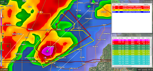
TORNADO WARNING AND SEVERE THUNDERSTORM WARNING LA
055
WFUS54 KLCH 210532
TORLCH
LAC001-039-053-097-210600-
/O.NEW.KLCH.TO.W.0011.170121T0532Z-170121T0600Z/
BULLETIN - EAS ACTIVATION REQUESTED
Tornado Warning
National Weather Service Lake Charles LA
1132 PM CST FRI JAN 20 2017
The National Weather Service in Lake Charles has issued a
* Tornado Warning for...
Northeastern Jefferson Davis Parish in southwestern Louisiana...
Southwestern Evangeline Parish in central Louisiana...
Northwestern Acadia Parish in southwestern Louisiana...
West central St. Landry Parish in central Louisiana...
* Until midnight CST
* At 1132 PM CST, a severe thunderstorm capable of producing a
tornado was located near Pine Island, or 7 miles north of Jennings,
moving northeast at 30 mph.
HAZARD...Tornado and quarter size hail.
SOURCE...Radar indicated rotation.
IMPACT...Flying debris will be dangerous to those caught without
shelter. Mobile homes will be damaged or destroyed.
Damage to roofs, windows, and vehicles will occur. Tree
damage is likely.
* This dangerous storm will be near...
Basile around 1155 PM CST.
Eunice and Duralde around 1200 AM CST.
Other locations impacted by this tornadic thunderstorm include
Hathaway.
PRECAUTIONARY/PREPAREDNESS ACTIONS...
This Tornado Warning replaces the Severe Thunderstorm Warning issued
for the same area.
TAKE COVER NOW! Move to an interior room on the lowest floor of a
sturdy building. Avoid windows. If you are outdoors, in a mobile
home, or in a vehicle, move to the closest substantial shelter and
protect yourself from flying debris.
&&
LAT...LON 3044 9231 3022 9271 3034 9280 3049 9266
3049 9262 3051 9261 3052 9262 3055 9259
3064 9251
TIME...MOT...LOC 0532Z 228DEG 28KT 3033 9270
TORNADO...RADAR INDICATED
HAIL...1.00IN
----------------------------------------------
849
WUUS54 KLCH 210528
SVRLCH
LAC001-003-039-053-210600-
/O.NEW.KLCH.SV.W.0019.170121T0528Z-170121T0600Z/
BULLETIN - IMMEDIATE BROADCAST REQUESTED
Severe Thunderstorm Warning
National Weather Service Lake Charles LA
1128 PM CST FRI JAN 20 2017
The National Weather Service in Lake Charles has issued a
* Severe Thunderstorm Warning for...
Northeastern Jefferson Davis Parish in southwestern Louisiana...
Southwestern Evangeline Parish in central Louisiana...
Northwestern Acadia Parish in southwestern Louisiana...
Southeastern Allen Parish in southwestern Louisiana...
* Until midnight CST
* At 1128 PM CST, a severe thunderstorm was located near Pine Island,
or 7 miles north of Jennings, moving northeast at 35 mph.
HAZARD...60 mph wind gusts and quarter size hail.
SOURCE...Radar indicated.
IMPACT...Hail damage to vehicles is expected. Expect wind damage
to roofs, siding, and trees.
* Locations impacted include...
Eunice, Jennings, Basile, Iota, Elton, Pine Island, Mowata,
Richard, Duralde, Hathaway and Roanoke.
PRECAUTIONARY/PREPAREDNESS ACTIONS...
A tornado watch remains in effect for the warned area. Tornadoes can
develop quickly from severe thunderstorms. Although a tornado is not
immediately likely, if one is spotted, act quickly and move to a
place of safety inside a sturdy structure, such as a small interior
room.
For your protection move to an interior room on the lowest floor of a
building.
&&
A tornado watch remains in effect until 200 AM CST for central and
southwestern Louisiana.
LAT...LON 3019 9274 3035 9282 3062 9257 3053 9245
3052 9246 3050 9246 3048 9249 3048 9238
3040 9228
TIME...MOT...LOC 0528Z 228DEG 29KT 3033 9269
HAIL...1.00IN
WIND...60MPH


Friday, January 20, 2017

SEVERE THUNDERSTORM WARNING LOUISIANA
420
WUUS54 KLCH 210426
SVRLCH
LAC001-003-039-053-210500-
/O.NEW.KLCH.SV.W.0017.170121T0426Z-170121T0500Z/
BULLETIN - IMMEDIATE BROADCAST REQUESTED
Severe Thunderstorm Warning
National Weather Service Lake Charles LA
1026 PM CST FRI JAN 20 2017
The National Weather Service in Lake Charles has issued a
* Severe Thunderstorm Warning for...
Northeastern Jefferson Davis Parish in southwestern Louisiana...
Southwestern Evangeline Parish in central Louisiana...
Northwestern Acadia Parish in southwestern Louisiana...
Allen Parish in southwestern Louisiana...
* Until 1100 PM CST
* At 1026 PM CST, a severe thunderstorm was located near Kinder,
moving east at 45 mph.
HAZARD...70 mph wind gusts and quarter size hail.
SOURCE...Radar indicated.
IMPACT...Hail damage to vehicles is expected. Expect considerable
tree damage. Wind damage is also likely to mobile homes,
roofs, and outbuildings.
* Locations impacted include...
Eunice, Oakdale, Kinder, Basile, Oberlin, Elton, Mittie, Harmony,
Duralde, Allen Parish Airport, Leblanc, Beaver and Bond.
PRECAUTIONARY/PREPAREDNESS ACTIONS...
For your protection move to an interior room on the lowest floor of a
building.
&&
A tornado watch remains in effect until 200 AM CST for central and
southwestern Louisiana.
LAT...LON 3089 9261 3053 9244 3052 9246 3050 9246
3048 9249 3048 9242 3046 9241 3044 9298
3060 9299 3060 9298 3070 9298
TIME...MOT...LOC 0426Z 250DEG 40KT 3053 9287
HAIL...1.00IN
WIND...70MPH


LOW BAROMETRIC PRESSURE FOR THIS FORECAST LOW PRESSURE SYSTEM
Ryan Maue
@RyanMaue
3 minutes ago


Your barometer in N Georgia and Carolinas may see lowest pressure for non-tropical Low (973 mb) in a generation.


WEST COAST BEING HAMMERED BY A STRONG PACIFIC STORM SYSTEM
STRONG GUSTY WINDS, HEAVY RAINS!
Chula Vista Police @ChulaVistaPD
1 hour ago

Chula Vista Police
Chula Vista Police asks the public to avoid driving tonight. The City is experiencing multiple traffic hazards and power outages

TORNADO WARNING LAKE CHARLES LA

WFUS54 KLCH 210256
TORLCH
LAC011-019-210330-
/O.NEW.KLCH.TO.W.0008.170121T0256Z-170121T0330Z/
BULLETIN - EAS ACTIVATION REQUESTED
Tornado Warning
National Weather Service Lake Charles LA
856 PM CST FRI JAN 20 2017
The National Weather Service in Lake Charles has issued a
* Tornado Warning for...
South central Beauregard Parish in southwestern Louisiana...
Northwestern Calcasieu Parish in southwestern Louisiana...
* Until 930 PM CST
* At 856 PM CST, a severe thunderstorm capable of producing a tornado
was located over Starks, moving northeast at 45 mph.
HAZARD...Tornado and quarter size hail.
SOURCE...Radar indicated rotation.
IMPACT...Flying debris will be dangerous to those caught without
shelter. Mobile homes will be damaged or destroyed.
Damage to roofs, windows, and vehicles will occur. Tree
damage is likely.
* This dangerous storm will be near...
Lunita around 905 PM CST.
De Quincy, Dequincy, Oretta and Buhler around 920 PM CST.
PRECAUTIONARY/PREPAREDNESS ACTIONS...
TAKE COVER NOW! Move to an interior room on the lowest floor of a
sturdy building. Avoid windows. If you are outdoors, in a mobile
home, or in a vehicle, move to the closest substantial shelter and
protect yourself from flying debris.
&&
LAT...LON 3037 9376 3055 9343 3028 9332 3020 9370
3023 9371 3029 9371 3030 9374 3036 9376
3036 9375
TIME...MOT...LOC 0256Z 243DEG 37KT 3032 9367
TORNADO...RADAR INDICATED
HAIL...1.00IN
$$
24


Subscribe to:
Posts (Atom)