Thursday, June 15, 2017

Wednesday, June 14, 2017
UPDATED MIAMI AND VICINITY 7-DAY FORECAST

Tonight Jun 14, 2017
0407 PM EDT
Mostly cloudy with scattered thunderstorms: Lows around 79°F. East southeast wind to 7 MPH. Chance of rain 40
percent.
Thursday Jun 15
Mostly cloudy with scattered thunderstorms during the day: Highs around 88°F. Heat index around 95°F. Southeast wind
to 9 MPH. Chance of rain 50 percent.
Mostly cloudy with scattered thunderstorms during the night:
Lows around 75°F. Southeast wind to 7 MPH. Chance of rain 50
percent.
Friday Jun 16
Mostly cloudy with thunderstorms likely during the day: Highs around 86°F. Heat index around 93°F.
South southeast wind to 9 MPH. Chance of
rain 60 percent.
Mostly cloudy with thunderstorms likely during the night: Lows around 79°F. South southeast wind to 8
MPH. Chance of precipitation 60 percent.
Saturday Jun 17
Mostly cloudy with scattered thunderstorms during the day: Highs around 88°F. Heat index around 95°F.
South southeast wind to 9 MPH, gusting
to 15 MPH. Chance of rain 40 percent.
Partly cloudy with scattered thunderstorms during the night:
Lows around 79°F. East southeast wind to
8 MPH. Chance of precipitation 50 percent.
Sunday Jun 18
Mostly cloudy with thunderstorms likely during the day: Highs around 88°F. Heat index around 97°F.
East southeast wind 7 to 14 MPH. Chance
of rain 50 percent.
Mostly cloudy with thunderstorms likely during the night: Lows around 79°F. East southeast wind to 15 MPH. Chance of rain 60
percent.
Monday Jun 19
Mostly cloudy with scattered thunderstorms during the day: Highs around 88°F. Heat index around 97°F.
East southeast wind to 15 MPH. Chance of
rain 50 percent.
Mostly cloudy with scattered thunderstorms during the night:
Lows around 79°F. East wind to 11 MPH. Chance of rain 50 percent.
Tuesday Jun 20
Partly cloudy with scattered thunderstorms during the day: Highs around 88°F. Heat index around 95°F.
East southeast wind to 10 MPH. Chance of
rain 50 percent.
FORECAST MAPS AND LIVE RADAR COURTESY OF N.W.S. IN MIAMI FLORIDA


TRACKING THE TROPICS JUNE 14, 2017 0349 PM EDT
Upper level winds over the northwest Caribbean remain hostile for development at this time. This are will also be monitored into next week...RTW
http://ralphstropicalweather.myfreesites.net
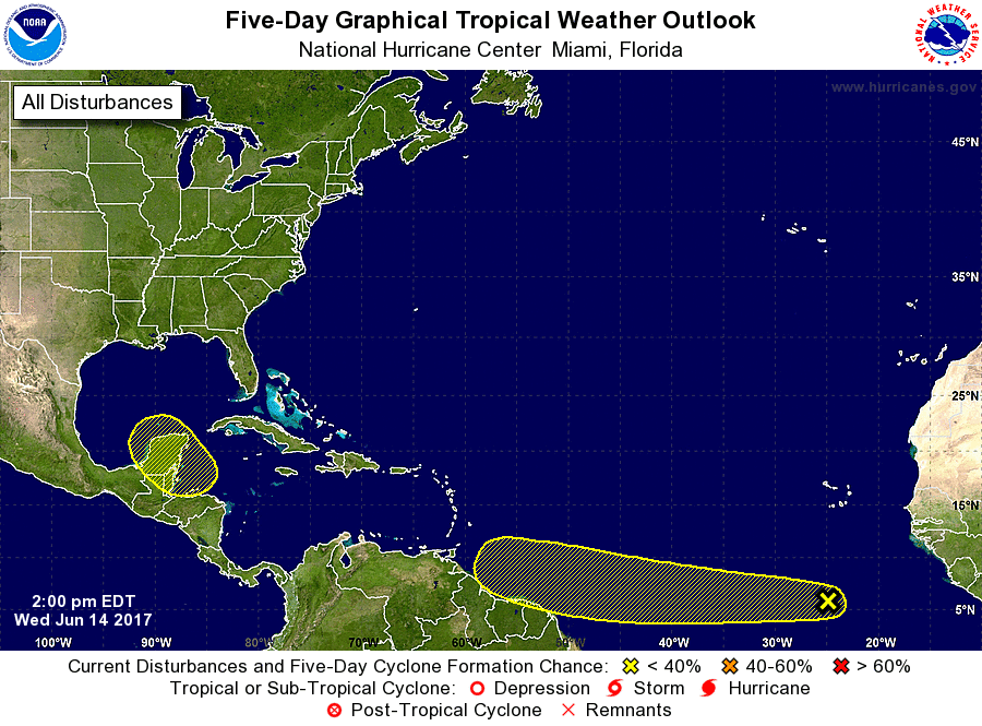


TRACKING THE TROPICS JUNE 14, 2017 1233 PM EDT
THIS LOW LATITUDE WAVE/LOW IS IN AN AREA OF LOW WIND SHEAR AND NO SAHARA DUST OR DRY AIR. SOME SLOW DEVELOPMENT OF THIS WAVE CAN OCCUR AS LONG AS IT STAYS IN THE LOWER LATITUDES DURING THE NEXT FEW DAYS.
THIS SYSTEM HAS A 10% CHANCE FOR DEVELOPMENT DURING THE NEXT 48 HRS.
Still Monitoring northwest Caribbean for tropical cyclone formation during the coming days and into next week. This system has a 20% chance for development during the next 5-days...RTW
http://ralphstropicalweather.myfreesites.net


Tuesday, June 13, 2017
UPDATED MIAMI AND VICINITY 7-DAY FORECAST

Tonight Jun 13, 2017
Partly cloudy with scattered showers: Lows around 79°F. East wind to 10 MPH. Chance
of rain 30 percent.
Wednesday Jun 14
Mostly cloudy with scattered showers during the day: Highs
around 88°F. Heat index around 95°F. Southeast
wind to 11 MPH. Chance of rain 40 percent.
Mostly cloudy with scattered thunderstorms during the night:
Lows around 79°F. East southeast wind to 7 MPH. Chance of rain 40 percent.
Thursday Jun 15
Mostly cloudy with showers likely during the day: Highs
around 88°F. Heat index around 97°F. South
southwest wind to 9 MPH. Chance of rain 60 percent.
Mostly cloudy with thunderstorms likely during the night: Lows
around 77°F. Southeast wind to 8 MPH. Chance of rain 50
percent.
Friday Jun 16
Mostly cloudy with thunderstorms likely during the day: Highs
around 88°F. Heat index around 95°F. Southeast
wind to 8 MPH. Chance of rain 60 percent.
Mostly cloudy with thunderstorms likely during the night: Lows
around 79°F. South southeast wind to 7 MPH. Chance of rain 60 percent.
Saturday Jun 17
Mostly cloudy with scattered showers during the day: Highs
around 88°F. Heat index around 97°F. East
southeast wind to 8 MPH, gusting to 15 MPH. Chance of rain 40
percent.
Mostly cloudy with scattered thunderstorms during the night:
Lows around 79°F. East southeast wind to 7 MPH, gusting to 12 MPH. Chance of rain
50 percent.
Sunday Jun 18
Mostly cloudy with scattered showers during the day: Highs
around 88°F. Heat index around 97°F. Southeast
wind 6 to 11 MPH, gusting to 21 MPH. Chance
of rain 40 percent.
Mostly cloudy with scattered thunderstorms during the night:
Lows around 79°F. Southeast wind to 10 MPH, gusting to 18 MPH. Chance of rain 40 percent.
Monday Jun 19
Mostly cloudy with scattered showers during the day: Highs
around 88°F. Heat index around 97°F. Southeast
wind to 11 MPH, gusting to 18 MPH. Chance of rain 50
percent.
Partly cloudy with scattered thunderstorms during the night:
Lows around 79°F. East southeast wind to 11 MPH. Chance of rain 50 percent.
FORECAST MAPS AND LIVE RADAR COURTESY OF N.W.S. MIAMI FLORIDA


Subscribe to:
Posts (Atom)