ZCZC MIATCPAT5 ALL TTAA00 KNHC DDHHMM BULLETIN Hurricane Maria Advisory Number 23 NWS National Hurricane Center Miami FL AL152017 500 PM AST Thu Sep 21 2017 ...TROPICAL STORM CONDITIONS BEGINNING TO SPREAD OVER THE TURKS AND CAICOS ISLANDS... SUMMARY OF 500 PM AST...2100 UTC...INFORMATION ---------------------------------------------- LOCATION...20.8N 69.8W ABOUT 90 MI...145 KM NE OF PUERTO PLATA DOMINICAN REPUBLIC ABOUT 95 MI...155 KM ESE OF GRAND TURK ISLAND MAXIMUM SUSTAINED WINDS...120 MPH...195 KM/H PRESENT MOVEMENT...NW OR 315 DEGREES AT 9 MPH...15 KM/H MINIMUM CENTRAL PRESSURE...960 MB...28.35 INCHES WATCHES AND WARNINGS -------------------- CHANGES WITH THIS ADVISORY: The government of the Dominican Republic has discontinued the Tropical Storm Warning along the southern coast of the Dominican Republic west of Cabo Engano. SUMMARY OF WATCHES AND WARNINGS IN EFFECT: A Hurricane Warning is in effect for... * Dominican Republic from Cabo Engano to Puerto Plata * Turks and Caicos Islands and the Southeastern Bahamas A Tropical Storm Warning is in effect for... * Dominican Republic west of Puerto Plata to the northern border of the Dominican Republic and Haiti A Tropical Storm Watch is in effect for... * Central Bahamas A Hurricane Warning means that hurricane conditions are expected somewhere within the warning area. Preparations to protect life and property should be rushed to completion. A Tropical Storm Warning means that tropical storm conditions are expected somewhere within the warning area. A Tropical Storm Watch means that tropical storm conditions are possible within the watch area, generally within 48 hours. Interests elsewhere in Hispaniola and the Bahamas should monitor the progress of Maria. For storm information specific to your area, please monitor products issued by your national meteorological service. DISCUSSION AND 48-HOUR OUTLOOK ------------------------------ At 500 PM AST (2100 UTC), the large eye of Hurricane Maria was located near latitude 20.8 North, longitude 69.8 West. Maria is moving toward the northwest near 9 mph (15 km/h), and this general motion is expected to continue through tonight. A turn toward the north-northwest is forecast early Friday, with that motion continuing through Saturday. On the forecast track, Maria's eye will continue to pass offshore of the northern coast of the Dominican Republic this evening, and then move near or just east of the Turks and Caicos Islands and southeastern Bahamas tonight and on Friday. Maximum sustained winds are near 120 mph (195 km/h) with higher gusts. Maria is a category 3 hurricane on the Saffir-Simpson Hurricane Wind Scale. Little change in strength is expected during the next couple of days. Hurricane-force winds extend outward up to 70 miles (110 km) from the center, and tropical-storm-force winds extend outward up to 160 miles (260 km). The estimated minimum central pressure is 960 mb (28.35 inches). HAZARDS AFFECTING LAND ---------------------- WIND: Hurricane and tropical storm conditions continue across portions of the Dominican Republic. Tropical storm conditions are beginning to spread across the Turks and Caicos Islands and the southeastern Bahamas, and hurricane conditions are expected tonight or early Friday. Tropical storm conditions are possible in the central Bahamas beginning late Friday. STORM SURGE: A dangerous storm surge accompanied by large and destructive waves will raise water levels by as much as 4 to 6 feet above normal tide levels in the hurricane warning area in the Dominican Republic, and 1 to 3 ft elsewhere along the northern coasts of the Dominican Republic and Haiti. A dangerous storm surge accompanied by large and destructive waves will raise water levels by as much as 9 to 12 feet above normal tide levels within the hurricane warning area of the southeastern Bahamas and the Turks and Caicos Islands. RAINFALL: Maria is expected to produce the following rainfall accumulations through Saturday: Puerto Rico...additional 4 to 8 inches, isolated maximum storm total amounts 40 inches Northern and eastern Dominican Republic, Turks and Caicos, and Mayaguana in southeast Bahamas...8 to 16 inches, isolated 20 inches Inagua Islands, Crooked Island, and rest of southeast Bahamas...4 to 8 inches Northern Haiti...4 to 8 inches Rainfall on these islands will continue to cause life-threatening flash floods and mudslides. SURF: Swells generated by Maria are affecting Puerto Rico, the Virgin Islands, the northern coast of Hispaniola, the Turks and Caicos Islands, and the southeastern Bahamas. These swells will reach the remainder of the Bahamas tonight and should reach portions of the United States southeastern coast on Friday. These swells are likely to cause life-threatening surf and rip current conditions. Please consult products from your local weather office. NEXT ADVISORY ------------- Next intermediate advisory at 800 PM AST. Next complete advisory at 1100 PM AST. $$ Forecaster Berg
Thursday, September 21, 2017
MARIA 05PM EDT UPDATE 9/21/2017
...TROPICAL STORM CONDITIONS BEGINNING TO SPREAD OVER THE TURKS AND
CAICOS ISLANDS...
LATEST MARIA UPDFATE 1100 AM EDT 9/21/2017
...MARIA HEADING TOWARD THE TURKS AND CAICOS ISLANDS...
...HEAVY RAINFALL AND FLOODING CONTINUES IN PUERTO RICO AND THE
DOMINICAN REPUBLIC...
ZCZC MIATCPAT5 ALL TTAA00 KNHC DDHHMM BULLETIN Hurricane Maria Advisory Number 22 NWS National Hurricane Center Miami FL AL152017 1100 AM AST Thu Sep 21 2017 ...MARIA HEADING TOWARD THE TURKS AND CAICOS ISLANDS... ...HEAVY RAINFALL AND FLOODING CONTINUES IN PUERTO RICO AND THE DOMINICAN REPUBLIC... SUMMARY OF 1100 AM AST...1500 UTC...INFORMATION ----------------------------------------------- LOCATION...20.2N 69.1W ABOUT 105 MI...175 KM ENE OF PUERTO PLATA DOMINICAN REPUBLIC ABOUT 155 MI...255 KM SE OF GRAND TURK ISLAND MAXIMUM SUSTAINED WINDS...115 MPH...185 KM/H PRESENT MOVEMENT...NW OR 310 DEGREES AT 9 MPH...15 KM/H MINIMUM CENTRAL PRESSURE...960 MB...28.35 INCHES WATCHES AND WARNINGS -------------------- CHANGES WITH THIS ADVISORY: The government of the Dominican Republic has discontinued the Tropical Storm Warning along the southern coast of the Dominican Republic west of Andres/Boca Chica. The Hurricane Watch from Isla Saona to Cabo Engano has also been discontinued. SUMMARY OF WATCHES AND WARNINGS IN EFFECT: A Hurricane Warning is in effect for... * Dominican Republic from Cabo Engano to Puerto Plata * Turks and Caicos Islands and the Southeastern Bahamas A Tropical Storm Warning is in effect for... * Dominican Republic west of Puerto Plata to the northern border of the Dominican Republic and Haiti * Dominican Republic west of Cabo Engano to Andres/Boca Chica A Tropical Storm Watch is in effect for... * Central Bahamas A Hurricane Warning means that hurricane conditions are expected somewhere within the warning area. Preparations to protect life and property should be rushed to completion. A Tropical Storm Warning means that tropical storm conditions are expected somewhere within the warning area. A Tropical Storm Watch means that tropical storm conditions are possible within the watch area, generally within 48 hours. Interests elsewhere in Hispaniola and the Bahamas should monitor the progress of Maria. For storm information specific to your area, please monitor products issued by your national meteorological service. DISCUSSION AND 48-HOUR OUTLOOK ------------------------------ At 1100 AM AST (1500 UTC), the large eye of Hurricane Maria was located near latitude 20.2 North, longitude 69.1 West. Maria is moving toward the northwest near 9 mph (15 km/h), and this general motion is expected to continue through tonight. A turn toward the north-northwest is forecast early Friday, with that motion continuing through early Saturday. On the forecast track, Maria's eye will continue to pass offshore of the northern coast of the Dominican Republic today, and then move near or just east of the Turks and Caicos Islands and southeastern Bahamas tonight and on Friday. Data from an Air Force Reserve reconnaissance aircraft indicate that maximum sustained winds remain near 115 mph (185 km/h) with higher gusts. Maria is a category 3 hurricane on the Saffir-Simpson Hurricane Wind Scale. Some strengthening is possible during the next day or so. Hurricane-force winds extend outward up to 60 miles (95 km) from the center, and tropical-storm-force winds extend outward up to 150 miles (240 km). The minimum central pressure based on aircraft data is 960 mb (28.35 inches). HAZARDS AFFECTING LAND ---------------------- WIND: Hurricane and tropical storm conditions continue across portions of the Dominican Republic. Tropical storm conditions are expected to begin in the Turks and Caicos Islands and the southeastern Bahamas later today, with hurricane conditions expected tonight or early Friday. Tropical storm conditions are possible in the central Bahamas beginning late Friday. Strong gusty winds are still possible today over portions of Puerto Rico, especially in heavier rainbands that are moving over the island. STORM SURGE: A dangerous storm surge accompanied by large and destructive waves will raise water levels by as much as 4 to 6 feet above normal tide levels in the hurricane warning area in the Dominican Republic, and 1 to 3 ft elsewhere along the northern coasts of the Dominican Republic and Haiti. A dangerous storm surge accompanied by large and destructive waves will raise water levels by as much as 9 to 12 feet above normal tide levels within the hurricane warning area of the southeastern Bahamas and the Turks and Caicos Islands. RAINFALL: Maria is expected to produce the following rainfall accumulations through Saturday: Puerto Rico...additional 4 to 8 inches, isolated maximum storm total amounts 35 inches. U.S. and British Virgin Islands...additional 2 to 4 inches. Northern and eastern Dominican Republic, Turks and Caicos, and Mayaguana in southeast Bahamas...8 to 16 inches, isolated 20 inches. Inagua Islands, Crooked Island, and rest of southeast Bahamas...4 to 8 inches. Northern Haiti...2 to 4 inches. Rainfall on these islands will continue to cause life-threatening flash floods and mudslides. SURF: Swells generated by Maria are affecting Puerto Rico, the Virgin Islands, the northern coast of Hispaniola, the Turks and Caicos Islands, and the southeastern Bahamas. These swells will reach the remainder of the Bahamas today and tonight and should reach portions of the United States southeastern coast on Friday. These swells are likely to cause life-threatening surf and rip current conditions. Please consult products from your local weather office. NEXT ADVISORY ------------- Next intermediate advisory at 200 PM AST. Next complete advisory at 500 PM AST. $$ Forecaster Berg
Wednesday, September 20, 2017
MARIA FORECAST ADVISORY 0500 PM EDT 9/20/2017
...CATASTROPHIC FLASH FLOODING OCCURRING OVER PORTIONS OF PUERTO
RICO...
...CONDITIONS NOW DETERIORATING OVER EASTERN DOMINICAN REPUBLIC...
000 WTNT35 KNHC 202038 TCPAT5 BULLETIN Hurricane Maria Advisory Number 19 NWS National Hurricane Center Miami FL AL152017 500 PM AST Wed Sep 20 2017 ...CATASTROPHIC FLASH FLOODING OCCURRING OVER PORTIONS OF PUERTO RICO... ...CONDITIONS NOW DETERIORATING OVER EASTERN DOMINICAN REPUBLIC... SUMMARY OF 500 PM AST...2100 UTC...INFORMATION ---------------------------------------------- LOCATION...18.8N 67.3W ABOUT 25 MI...45 KM NNW OF AGUADILLA PUERTO RICO ABOUT 75 MI...120 KM E OF PUNTA CANA DOMINICAN REPUBLIC MAXIMUM SUSTAINED WINDS...110 MPH...175 KM/H PRESENT MOVEMENT...NW OR 305 DEGREES AT 12 MPH...19 KM/H MINIMUM CENTRAL PRESSURE...957 MB...28.26 INCHES WATCHES AND WARNINGS -------------------- CHANGES WITH THIS ADVISORY: The Hurricane Warning for the U.S. Virgin Islands has been discontinued. The government of Antigua and Barbuda has discontinued the Hurricane Warning for the British Virgin Islands. SUMMARY OF WATCHES AND WARNINGS IN EFFECT: A Hurricane Warning is in effect for... * Puerto Rico, Culebra, and Vieques * Dominican Republic from Cabo Engano to Puerto Plata * Turks and Caicos Islands and the Southeastern Bahamas A Tropical Storm Warning is in effect for... * Dominican Republic west of Puerto Plata to the northern border of the Dominican Republic and Haiti * Dominican Republic west of Cabo Engano to Punta Palenque A Hurricane Watch is in effect for... * Dominican Republic from Isla Saona to Cabo Engano A Hurricane Warning means that hurricane conditions are expected somewhere within the warning area. Preparations to protect life and property should be rushed to completion. A Tropical Storm Warning means that tropical storm conditions are expected somewhere within the warning area. A Hurricane Watch means that hurricane conditions are possible within the watch area. A watch is typically issued 48 hours before the anticipated first occurrence of tropical-storm-force winds, conditions that make outside preparations difficult or dangerous. Interests elsewhere in Hispaniola and the Bahamas should monitor the progress of Maria. For storm information specific to your area in the United States, including possible inland watches and warnings, please monitor products issued by your local National Weather Service forecast office. For storm information specific to your area outside the United States, please monitor products issued by your national meteorological service. DISCUSSION AND 48-HOUR OUTLOOK ------------------------------ At 500 PM AST (2100 UTC), the eye of Hurricane Maria was located near latitude 18.8 North, longitude 67.3 West. Maria is moving toward the northwest near 12 mph (19 km/h), and this general motion with a decrease in forward speed is expected through Thursday night. A turn toward the north-northwest is forecast on Friday. On the forecast track, the center of Maria will continue to move away from the northwestern coast of Puerto Rico this evening. The center will then pass offshore of the northeastern coast of the Dominican Republic tonight and Thursday and then move near the Turks and Caicos Islands and southeastern Bahamas Thursday night and Friday. Data from an Air Force Reserve Hurricane Hunter aircraft indicate that maximum sustained winds are near 110 mph (175 km/h) with higher gusts. Some strengthening is forecast during the next day or two, and Maria could regain major hurricane status by Thursday. Hurricane-force winds extend outward up to 60 miles (95 km) from the center, and tropical-storm-force winds extend outward up to 150 miles (240 km). The minimum central pressure based on data from the Air Force aircraft is 957 mb (28.26 inches). HAZARDS AFFECTING LAND ---------------------- WIND: Hurricane and tropical storm conditions are still occurring over portions of Puerto Rico. Tropical storm conditions are spreading across the warning areas in the Dominican Republic, and hurricane conditions should start in the hurricane warning area tonight. Tropical storm conditions are expected to begin in the Turks and Caicos Islands and the southeastern Bahamas on Thursday, with hurricane conditions starting Thursday night. STORM SURGE: The combination of a dangerous storm surge and the tide will cause normally dry areas near the coast to be flooded by rising waters moving inland from the shoreline. The water is expected to reach the following heights above ground if the peak surge occurs at the time of high tide... Puerto Rico...3 to 5 ft The deepest water will occur along the immediate coast in areas of onshore wind over western portions of Puerto Rico, where the surge will be accompanied by large and destructive waves. Surge-related flooding depends on the relative timing of the surge and the tidal cycle, and can vary greatly over short distances. For information specific to your area, please see products issued by your local National Weather Service forecast office. A dangerous storm surge accompanied by large and destructive waves will raise water levels by as much as 4 to 6 feet above normal tide levels in the hurricane warning area in the Dominican Republic, and 1 to 3 ft elsewhere along the northern coasts of the Dominican Republic and Haiti. A dangerous storm surge accompanied by large and destructive waves will raise water levels by as much as 9 to 12 feet above normal tide levels within the hurricane warning area of the southeastern Bahamas and the Turks and Caicos Islands. RAINFALL: Maria is expected to produce the following rainfall totals through Friday: Puerto Rico...20 to 25 inches, isolated 35 inches U.S. and British Virgin Islands...additional 3 to 5 inches Northern and eastern Dominican Republic, Turks and Caicos and southeast Bahamas...8 to 16 inches, isolated 20 inches Northern Haiti...2 to 4 inches Rainfall on these islands will cause life-threatening flash floods and mudslides SURF: Swells generated by Maria are affecting the Leeward Islands, Puerto Rico, and the Virgin Islands. These swells will begin affecting the northern coast of Hispaniola, the Turks and Caicos Islands, and the Southeastern Bahamas during the next day or two. These swells are likely to cause life-threatening surf and rip current conditions. Please consult products from your local weather office. NEXT ADVISORY ------------- Next intermediate advisory at 800 PM AST. Next complete advisory at 1100 PM AST. $$ Forecaster Berg
http://ralphstropicalweather.myfreesites.net
WINDFIELD RADIUS IF IT IS STILL THIS SIZE AT 02PM EDT 9/20/17
THIS WIND FIELD IS FROM THE 11 AM EDT ADVISORY SO IF IT REMAINS THIS SIZE A DIAMETER THEN MINUS THE CAT 4-5 WINDS IT WOULD BE LOOKING LIKE THIS.
GIVES YOU AN IDEA OF WINDS STILL AFFECTING THE ISLAND AND MOVING INTO DOMINICAN REPUBLIC...RTW
MARIA PRESENT POSITION AS OF 2PM EDT 9/20/17
Here is the past coordinate positions and present location of center of Maria as it entered the Atlantic.
12Z MODEL RUN FOR MARIA, AND THOSE OF YOU WORRIED ABOUT LEE
Maria's trackwell in agreement until the end of the forecast run where it could either turn back toward the U.S. or the northeast. Florida has no worries!
Jose still meandering and model run a bit more complex not in well agreement all over the place but turning the cyclone back toward the U.S. mainland.
As for the remnants of Lee they seems to have a chance for development into a tropical cyclone but this system will not be a threat to land only to the shipping lanes.
MARIA UPDATE 1135 PM EDT SEPT 20 2017
...DESTRUCTIVE WINDS AND FLOODING CONTINUE OVER PORTIONS OF PUERTO
RICO...
...CENTER OF MARIA APPROACHING THE NORTHERN COAST OF PUERTO RICO...
000 WTNT35 KNHC 201440 TCPAT5 BULLETIN Hurricane Maria Advisory Number 18 NWS National Hurricane Center Miami FL AL152017 1100 AM AST Wed Sep 20 2017 ...DESTRUCTIVE WINDS AND FLOODING CONTINUE OVER PORTIONS OF PUERTO RICO... ...CENTER OF MARIA APPROACHING THE NORTHERN COAST OF PUERTO RICO... SUMMARY OF 1100 AM AST...1500 UTC...INFORMATION ----------------------------------------------- LOCATION...18.4N 66.5W ABOUT 15 MI...25 KM ESE OF ARECIBO PUERTO RICO ABOUT 25 MI...40 KM W OF SAN JUAN PUERTO RICO MAXIMUM SUSTAINED WINDS...140 MPH...220 KM/H PRESENT MOVEMENT...NW OR 305 DEGREES AT 12 MPH...19 KM/H MINIMUM CENTRAL PRESSURE...930 MB...27.47 INCHES WATCHES AND WARNINGS -------------------- CHANGES WITH THIS ADVISORY: The government of France has discontinued the Tropical Storm Warning for St. Martin and St. Barthelemy. The government of St. Maarten has discontinued the Tropical Storm Warning and Hurricane Watch for St. Maarten. The government of the Netherlands has discontinued the Tropical Storm Warning for Saba. SUMMARY OF WATCHES AND WARNINGS IN EFFECT: A Hurricane Warning is in effect for... * U.S. Virgin Islands * British Virgin Islands * Puerto Rico, Culebra, and Vieques * Dominican Republic from Cabo Engano to Puerto Plata * Turks and Caicos Islands and the Southeastern Bahamas A Tropical Storm Warning is in effect for... * Dominican Republic west of Puerto Plata to the northern border of the Dominican Republic and Haiti * Dominican Republic west of Cabo Engano to Punta Palenque A Hurricane Watch is in effect for... * Dominican Republic from Isla Saona to Cabo Engano A Hurricane Warning means that hurricane conditions are expected somewhere within the warning area. Preparations to protect life and property should be rushed to completion. A Tropical Storm Warning means that tropical storm conditions are expected somewhere within the warning area. A Hurricane Watch means that hurricane conditions are possible within the watch area. A watch is typically issued 48 hours before the anticipated first occurrence of tropical-storm-force winds, conditions that make outside preparations difficult or dangerous. Interests elsewhere in Hispaniola and the Bahamas should monitor the progress of Maria. For storm information specific to your area in the United States, including possible inland watches and warnings, please monitor products issued by your local National Weather Service forecast office. For storm information specific to your area outside the United States, please monitor products issued by your national meteorological service. DISCUSSION AND 48-HOUR OUTLOOK ------------------------------ At 1100 AM AST (1500 UTC), the center of Hurricane Maria was located inland over Puerto Rico near latitude 18.4 North, longitude 66.5 West. Maria is moving toward the northwest near 12 mph (19 km/h), and this general motion with a gradual decrease in forward speed is expected through early Friday. On the forecast track, the center of Maria will move offshore of the northern coast of Puerto Rico during the next couple of hours. The center will then pass offshore of the northeastern coast of the Dominican Republic tonight and Thursday and then move near the Turks and Caicos Islands and southeastern Bahamas Thursday night and Friday. Maximum sustained winds are near 140 mph (220 km/h) with higher gusts. Maria is a category 4 hurricane on the Saffir-Simpson Hurricane Wind Scale. Little change in strength is forecast during the next 48 hours, and Maria is expected to remain a dangerous major hurricane through Friday. Hurricane-force winds extend outward up to 60 miles (95 km) from the center, and tropical-storm-force winds extend outward up to 150 miles (240 km). The estimated minimum central pressure is 930 mb (27.47 inches). HAZARDS AFFECTING LAND ---------------------- WIND: Hurricane and tropical storm conditions are occurring over Puerto Rico and the Virgin Islands. Tropical storm conditions are expected to begin in the warning areas in the Dominican Republic this afternoon, with hurricane conditions starting in the hurricane warning area tonight. Tropical storm conditions are expected to begin in the Turks and Caicos Islands and the southeastern Bahamas Thursday morning, with hurricane conditions starting Thursday evening. Wind speeds atop and on the windward sides of hills and mountains and on high-rise buildings could be much stronger than the near- surface winds indicated in this advisory. STORM SURGE: The combination of a dangerous storm surge and the tide will cause normally dry areas near the coast to be flooded by rising waters moving inland from the shoreline. The water is expected to reach the following heights above ground if the peak surge occurs at the time of high tide... Puerto Rico...6 to 9 ft The deepest water will occur along the immediate coast near and to the north and east of the landfall location, where the surge will be accompanied by large and destructive waves. Surge-related flooding depends on the relative timing of the surge and the tidal cycle, and can vary greatly over short distances. For information specific to your area, please see products issued by your local National Weather Service forecast office. A dangerous storm surge accompanied by large and destructive waves will raise water levels by as much as 4 to 6 feet above normal tide levels in the hurricane warning area in the Dominican Republic, and 1 to 3 ft elsewhere along the northern coasts of the Dominican Republic and Haiti. A dangerous storm surge accompanied by large and destructive waves will raise water levels by as much as 10 to 15 feet above normal tide levels in the hurricane warning area near and to the north of the center of Maria for both the Southeastern Bahamas and the Turks and Caicos Islands. RAINFALL: Maria is expected to produce the following rainfall totals through Friday: Puerto Rico...12 to 18 inches, isolated 25 inches U.S. and British Virgin Islands...additional 5 to 10 inches, isolated 15 inches Northern and eastern Dominican Republic, Turks and Caicos and southeast Bahamas...8 to 16 inches, isolated 20 inches Northern Haiti...2 to 4 inches Rainfall on these islands will cause life-threatening flash floods and mudslides TORNADOES: Several tornadoes are possible over Puerto Rico and the U.S. Virgin Islands today. THE EYE: Do not venture outside when the calm eye of the hurricane passes over, as dangerous winds will return very quickly when the eye moves away. SURF: Swells generated by Maria are affecting the Leeward Islands, Puerto Rico, and the Virgin Islands. These swells will begin affecting the northern coast of Hispaniola, the Turks and Caicos Islands, and the Southeastern Bahamas during the next day or two. These swells are likely to cause life-threatening surf and rip current conditions. Please consult products from your local weather office. NEXT ADVISORY ------------- Next intermediate advisory at 200 PM AST. Next complete advisory at 500 PM AST. $$ Forecaster Berg
Tuesday, September 19, 2017
MARIA 1100 PM EDT UPDATE 9/19/17
...EYE OF POTENTIALLY CATASTROPHIC CATEGORY 5 HURRICANE MARIA
NEARING ST. CROIX...
...CORE EXPECTED TO REACH SOUTHEASTERN PUERTO RICO WEDNESDAY
MORNING...
ZCZC MIATCPAT5 ALL TTAA00 KNHC DDHHMM BULLETIN Hurricane Maria Advisory Number 16 NWS National Hurricane Center Miami FL AL152017 1100 PM AST Tue Sep 19 2017 ...EYE OF POTENTIALLY CATASTROPHIC CATEGORY 5 HURRICANE MARIA NEARING ST. CROIX... ...CORE EXPECTED TO REACH SOUTHEASTERN PUERTO RICO WEDNESDAY MORNING... SUMMARY OF 1100 PM AST...0300 UTC...INFORMATION ----------------------------------------------- LOCATION...17.3N 64.7W ABOUT 30 MI...45 KM SSE OF ST. CROIX ABOUT 120 MI...190 KM SE OF SAN JUAN PUERTO RICO MAXIMUM SUSTAINED WINDS...175 MPH...280 KM/H PRESENT MOVEMENT...WNW OR 300 DEGREES AT 10 MPH...17 KM/H MINIMUM CENTRAL PRESSURE...909 MB...26.85 INCHES WATCHES AND WARNINGS -------------------- CHANGES WITH THIS ADVISORY: None SUMMARY OF WATCHES AND WARNINGS IN EFFECT: A Hurricane Warning is in effect for... * U.S. Virgin Islands * British Virgin Islands * Puerto Rico, Culebra, and Vieques * Dominican Republic from Cabo Engano to Puerto Plata A Tropical Storm Warning is in effect for... * Saba and St. Eustatius * St. Maarten * Guadeloupe * Dominican Republic west of Puerto Plata to the northern border of the Dominican Republic and Haiti * Dominican Republic west of Cabo Engano to Punta Palenque A Hurricane Watch is in effect for... * Saba and St. Eustatius * St. Maarten * St. Martin and St. Barthelemy * Dominican Republic from Isla Saona to Cabo Engano * Turks and Caicos Islands and the Southeastern Bahamas A Hurricane Warning means that hurricane conditions are expected somewhere within the warning area. Preparations to protect life and property should be rushed to completion. A Tropical Storm Warning means that tropical storm conditions are expected somewhere within the warning area. A Hurricane Watch means that hurricane conditions are possible within the watch area. A watch is typically issued 48 hours before the anticipated first occurrence of tropical-storm-force winds, conditions that make outside preparations difficult or dangerous. Interests elsewhere in Hispaniola and the Bahamas should monitor the progress of Maria. For storm information specific to your area in the United States, including possible inland watches and warnings, please monitor products issued by your local National Weather Service forecast office. For storm information specific to your area outside the United States, please monitor products issued by your national meteorological service. DISCUSSION AND 48-HOUR OUTLOOK ------------------------------ At 1100 PM AST (0300 UTC), the center of Hurricane Maria was located near latitude 17.3 North, longitude 64.7 West. Maria is moving toward the west-northwest near 10 mph (17 km/h). A west-northwest to northwest motion is expected to continue through Wednesday night, followed by a northwestward motion on Thursday. On the forecast track, the eye of Maria will move near or over St. Croix in the U.S. Virgin Islands within the next couple of hours, then cross Puerto Rico on Wednesday, and pass just north of the northeast coast of the Dominican Republic Wednesday night and Thursday. Maximum sustained winds are near 175 mph (280 km/h) with higher gusts. Maria is a potentially catastrophic category 5 hurricane on the Saffir-Simpson Hurricane Wind Scale. Some fluctuations in intensity could occur before the hurricane reaches Puerto Rico, but Maria is forecast to remain an extremely dangerous category 4 or 5 hurricane as it moves near or over the Virgin Islands and Puerto Rico. Slow weakening is expected after the hurricane emerges over the Atlantic north of Puerto Rico and the Dominican Republic. Reports from reconnaissance aircraft indicate that the area of hurricane-force winds has increased in size. Hurricane-force winds now extend outward up to 60 miles (95 km) from the center and tropical-storm-force winds extend outward up to 150 miles (240 km). The estimated minimum central pressure is 909 mb (26.85 inches). HAZARDS AFFECTING LAND ---------------------- WIND: Tropical storm conditions will continue in portions of the warning area in the Leeward Islands tonight. Tropical storm and hurricane conditions are occurring over the Virgin Islands and will spread over Puerto Rico overnight. Hurricane conditions are expected within the hurricane warning area in the Dominican Republic late Wednesday, with tropical storm conditions expected by early Wednesday. Tropical storm conditions are expected in the tropical storm warning areas in the Dominican Republic on Wednesday. Hurricane and tropical storm conditions are possible on Thursday in the Turks and Caicos Islands and the southeastern Bahamas. Wind speeds atop and on the windward sides of hills and mountains and on high-rise buildings could be much stronger than the near- surface winds indicated in this advisory. STORM SURGE: A dangerous storm surge accompanied by large and destructive waves will raise water levels by as much as 7 to 11 feet above normal tide levels in the hurricane warning area near where the center of Maria moves across the Leeward Islands and the British Virgin Islands. A dangerous storm surge accompanied by large and destructive waves will raise water levels by as much as 4 to 6 feet above normal tide levels in the hurricane warning area in the Dominican Republic, and 1 to 3 ft elsewhere along the northern coasts of the Dominican Republic and Haiti. The combination of a dangerous storm surge and the tide will cause normally dry areas near the coast to be flooded by rising waters moving inland from the shoreline. The water is expected to reach the following heights above ground if the peak surge occurs at the time of high tide... Puerto Rico and the U.S. Virgin Islands...6 to 9 ft The deepest water will occur along the immediate coast near and to the north and east of the landfall location, where the surge will be accompanied by large and destructive waves. Surge-related flooding depends on the relative timing of the surge and the tidal cycle, and can vary greatly over short distances. For information specific to your area, please see products issued by your local National Weather Service forecast office. RAINFALL: Maria is expected to produce the following rain accumulations through Friday: Central and southern Leeward Islands...additional 1 to 3 inches. Northern Leeward Islands from Barbuda to Anguilla...additional 3 to 6 inches. U.S. and British Virgin Islands...additional 8 to 12 inches, isolated 16 inches. Puerto Rico...12 to 18 inches, isolated 25 inches. Eastern Dominican Republic...4 to 8 inches, isolated 12 inches. Rainfall on all of these islands will cause life-threatening flash floods and mudslides. TORNADOES: Several tornadoes are possible over Puerto Rico and the U. S. Virgin Islands tonight and Wednesday. SURF: Swells generated by Maria are affecting the Leeward Islands, Puerto Rico, and the Virgin Islands. These swells will begin affecting the northern coast of Hispaniola, the Turks and Caicos Islands, and the Southeastern Bahamas during the next day or two. These swells are likely to cause life-threatening surf and rip current conditions. Please consult products from your local weather office. NEXT ADVISORY ------------- Next intermediate advisory at 200 AM AST. Next complete advisory at 500 AM AST. $$ Forecaster Brown
MARIA STORM UPDATE 0500 PM EDT 9/19/17
...PREPARATIONS AGAINST LIFE-THREATENING STORM SURGE AND RAINFALL FLOODING AND DESTRUCTIVE WINDS SHOULD BE RUSHED TO COMPLETION...
ZCZC MIATCPAT5 ALL TTAA00 KNHC DDHHMM BULLETIN Hurricane Maria Advisory Number 15 NWS National Hurricane Center Miami FL AL152017 500 PM AST Tue Sep 19 2017 ...POTENTIALLY CATASTROPHIC HURRICANE MARIA EXPECTED TO PASS NEAR THE U. S. VIRGIN ISLANDS TONIGHT AND OVER PUERTO RICO ON WEDNESDAY... ...PREPARATIONS AGAINST LIFE-THREATENING STORM SURGE AND RAINFALL FLOODING AND DESTRUCTIVE WINDS SHOULD BE RUSHED TO COMPLETION... SUMMARY OF 500 PM AST...2100 UTC...INFORMATION ---------------------------------------------- LOCATION...16.8N 64.0W ABOUT 80 MI...130 KM SE OF ST. CROIX ABOUT 175 MI...285 KM SE OF SAN JUAN PUERTO RICO MAXIMUM SUSTAINED WINDS...165 MPH...270 KM/H PRESENT MOVEMENT...WNW OR 300 DEGREES AT 10 MPH...17 KM/H MINIMUM CENTRAL PRESSURE...916 MB...27.05 INCHES WATCHES AND WARNINGS -------------------- CHANGES WITH THIS ADVISORY: The Meteorological Service of the Bahamas has issued a Hurricane Watch for the Turks and Caicos Islands and the Southeastern Bahamas. The Meteorological Service of Antigua has discontinued the Tropical Storm Warning for Antigua and Barbuda. The Meteorological Service of Barbados has discontinued the Hurricane Warning for Dominica. SUMMARY OF WATCHES AND WARNINGS IN EFFECT: A Hurricane Warning is in effect for... * St. Kitts, Nevis, and Montserrat * U.S. Virgin Islands * British Virgin Islands * Puerto Rico, Culebra, and Vieques * Cabo Engano to Puerto Plata A Tropical Storm Warning is in effect for... * Saba and St. Eustatius * St. Maarten * Anguilla * Guadeloupe * West of Puerto Plata to the northern border of the Dominican Republic and Haiti * West of Cabo Engano to Punta Palenque A Hurricane Watch is in effect for... * Saba and St. Eustatius * St. Maarten * St. Martin and St. Barthelemy * Anguilla * Isla Saona to Cabo Engano * Turks and Caicos Islands and the Southeastern Bahamas A Hurricane Warning means that hurricane conditions are expected somewhere within the warning area. Preparations to protect life and property should be rushed to completion. A Tropical Storm Warning means that tropical storm conditions are expected somewhere within the warning area. A Hurricane Watch means that hurricane conditions are possible within the watch area. A watch is typically issued 48 hours before the anticipated first occurrence of tropical-storm-force winds, conditions that make outside preparations difficult or dangerous. Interests elsewhere in Hispaniola and the Bahamas should monitor the progress of Maria. Additional watches and warnings may be required tonight or Wednesday. For storm information specific to your area in the United States, including possible inland watches and warnings, please monitor products issued by your local National Weather Service forecast office. For storm information specific to your area outside the United States, please monitor products issued by your national meteorological service. DISCUSSION AND 48-HOUR OUTLOOK ------------------------------ At 500 PM AST (2100 UTC), the eye of Hurricane Maria was located near latitude 16.8 North, longitude 64.0 West. Maria is moving toward the west-northwest near 10 mph (17 km/h), and this general motion is expected to continue through Wednesday night. On the forecast track, the eye of Maria will move near or over the U. S. Virgin Islands tonight, cross Puerto Rico on Wednesday, and then pass just north of the coast of the Dominican Republic Wednesday night and Thursday. Reports from an Air Force Reserve Hurricane Hunter aircraft indicate that maximum sustained winds are near 165 mph (270 km/h) with higher gusts. Maria is a potentially catastrophic category 5 hurricane on the Saffir-Simpson Hurricane Wind Scale. Some fluctuations in intensity are likely during the next day or so, but Maria is forecast to remain an extremely dangerous category 4 or 5 hurricane as it moves near or over the Virgin Islands and Puerto Rico. Slow weakening is expected after the hurricane emerges over the Atlantic north of Puerto Rico and the Dominican Republic. Hurricane-force winds extend outward up to 35 miles (55 km) from the center and tropical-storm-force winds extend outward up to 140 miles (220 km). The latest minimum central pressure reported by the Hurricane Hunter aircraft is 916 mb (27.05 inches). HAZARDS AFFECTING LAND ---------------------- WIND: Hurricane conditions will continue in portions of the hurricane warning area in the Leeward Islands this evening, and spread into the Virgin Islands and Puerto Rico tonight and Wednesday. Tropical storm conditions are occuring over the remainder of the Leeward Islands, and are spreading over the Virgin Islands at this time. Tropical storm conditions should spread over Puerto Rico during the next several hours. Hurricane conditions are expected within the hurricane warning area in the Dominican Republic late Wednesday, with tropical storm conditions expected by early Wednesday. Tropical storm conditions are expected in the tropical storm warning areas in the Dominican Republic on Wednesday. Hurricane conditions are possible on Thursday in the Turks and Caicos Islands and the southeastern Bahamas. Wind speeds atop and on the windward sides of hills and mountains and on high-rise buildings could be much stronger than the near- surface winds indicated in this advisory. STORM SURGE: A dangerous storm surge accompanied by large and destructive waves will raise water levels by as much as 7 to 11 feet above normal tide levels in the hurricane warning area near where the center of Maria moves across the Leeward Islands and the British Virgin Islands. A dangerous storm surge accompanied by large and destructive waves will raise water levels by as much as 4 to 6 feet above normal tide levels in the hurricane warning area in the Dominican Republic, and 1 to 3 ft elsewhere along the northern coasts of the Dominican Republic and Haiti. The combination of a dangerous storm surge and the tide will cause normally dry areas near the coast to be flooded by rising waters moving inland from the shoreline. The water is expected to reach the following heights above ground if the peak surge occurs at the time of high tide... Puerto Rico and the U.S. Virgin Islands...6 to 9 ft The deepest water will occur along the immediate coast near and to the north and east of the landfall location, where the surge will be accompanied by large and destructive waves. Surge-related flooding depends on the relative timing of the surge and the tidal cycle, and can vary greatly over short distances. For information specific to your area, please see products issued by your local National Weather Service forecast office. RAINFALL: Maria is expected to produce the following rain accumulations through Thursday: Central and southern Leeward Islands...10 to 15 inches, isolated 20 inches. U.S. and British Virgin Islands...10 to 15 inches, isolated 20 inches. Puerto Rico...12 to 18 inches, isolated 25 inches. Northern Leeward Islands from Barbuda to Anguilla...4 to 8 inches, isolated 10 inches. Windward Islands and Barbados...2 to 4 inches, isolated 6 inches. Eastern Dominican Republic...4 to 8 inches, isolated 12 inches. Rainfall on all of these islands will cause life-threatening flash floods and mudslides. TORNADOES: Several tornadoes are possible over Puerto Rico and the U. S. Virgin Islands tonight and Wednesday. SURF: Swells generated by Maria are affecting the Leeward Islands, Puerto Rico, and the Virgin Islands. These swells are likely to cause life-threatening surf and rip current conditions. Please consult products from your local weather office. NEXT ADVISORY ------------- Next intermediate advisory at 800 PM AST. Next complete advisory at 1100 PM AST. Tropical Cyclone Updates will be issued hourly in between these advisories. $$ Forecaster Beven
18Z MODEL RUN FOR MARIA AND JOSE 0310 PM EDT SEPT 19, 2017
MODELS ARE UNFORTUNATELY IN AGREEMENT WITH A LANDFALL OVER PUERTO RICO. AFTER THAT A BRUSH WITH NORTHEAST COAST OF DOMINICAN REPUBLIC AND MAYBE A BRUSH WITH THE SOUTHEASTERN BAHAMAS BEFORE MAKING A TURN TO THE NORTH. BEYOND FORECAST BECOMES SPREADS OUT...RTW
JOSE STILL STUCK BUT COULD LOOP BACK TOWARD THE U.S. AS MARIA TRACKS NORTHWARD.
11AM UPDATE FOR MARIA AND JOSE SEPT 19, 2017
...POTENTIALLY CATASTROPHIC HURRICANE MARIA CONTINUES WEST-
NORTHWESTWARD TOWARD THE VIRGIN ISLANDS AND PUERTO RICO...
...PREPARATIONS AGAINST LIFE-THREATENING STORM SURGE AND RAINFALL
FLOODING AND DESTRUCTIVE WINDS SHOULD BE RUSHED TO COMPLETION...
...JOSE MAINTAINING STATUS AS A CATEGORY 1 HURRICANE... ...DANGEROUS SURF AND RIP CURRENTS EXPECTED TO CONTINUE ALONG THE EAST COAST OF THE UNITED STATES FOR SEVERAL MORE DAYS...
000 WTNT35 KNHC 191447 TCPAT5 BULLETIN Hurricane Maria Advisory Number 14 NWS National Hurricane Center Miami FL AL152017 1100 AM AST Tue Sep 19 2017 ...POTENTIALLY CATASTROPHIC HURRICANE MARIA CONTINUES WEST- NORTHWESTWARD TOWARD THE VIRGIN ISLANDS AND PUERTO RICO... ...PREPARATIONS AGAINST LIFE-THREATENING STORM SURGE AND RAINFALL FLOODING AND DESTRUCTIVE WINDS SHOULD BE RUSHED TO COMPLETION... SUMMARY OF 1100 AM AST...1500 UTC...INFORMATION ----------------------------------------------- 
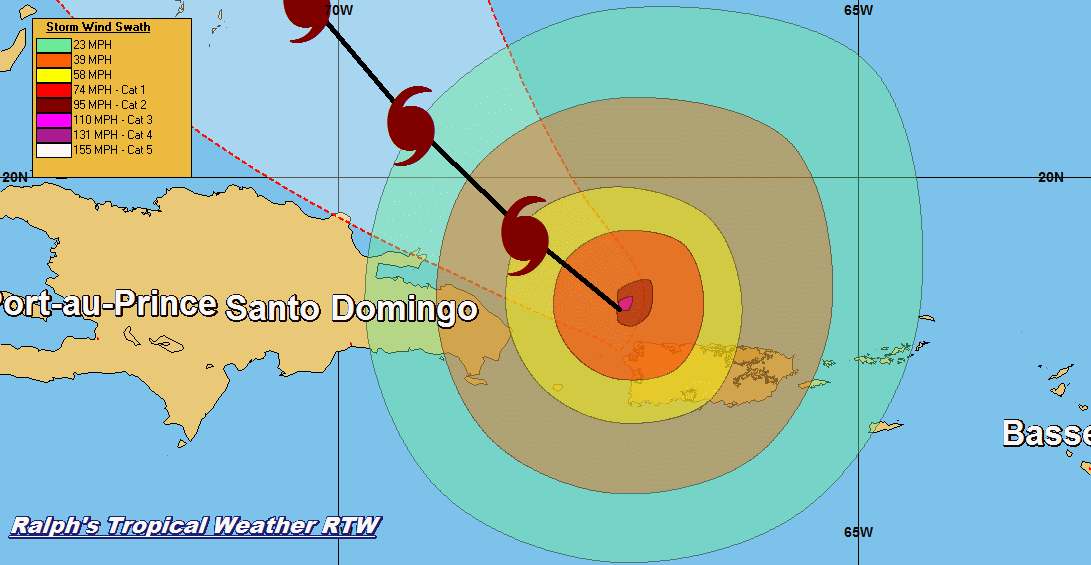
LOCATION...16.3N 63.1W ABOUT 115 MI...180 KM W OF GUADELOUPE ABOUT 150 MI...240 KM SE OF ST. CROIX MAXIMUM SUSTAINED WINDS...160 MPH...260 KM/H PRESENT MOVEMENT...WNW OR 300 DEGREES AT 10 MPH...17 KM/H MINIMUM CENTRAL PRESSURE...927 MB...27.37 INCHES WATCHES AND WARNINGS -------------------- CHANGES WITH THIS ADVISORY: None. SUMMARY OF WATCHES AND WARNINGS IN EFFECT: A Hurricane Warning is in effect for... * Guadeloupe * Dominica * St. Kitts, Nevis, and Montserrat * U.S. Virgin Islands * British Virgin Islands * Puerto Rico, Culebra, and Vieques A Tropical Storm Warning is in effect for... * Antigua and Barbuda * Saba and St. Eustatius * St. Maarten * Anguilla * Martinique A Hurricane Watch is in effect for... * Saba and St. Eustatius * St. Maarten * St. Martin and St. Barthelemy * Anguilla * Isla Saona to Puerto Plata A Tropical Storm Watch is in effect for... * West of Puerto Plata to the northern Dominican Republic-Haiti border A Hurricane Warning means that hurricane conditions are expected somewhere within the warning area. Preparations to protect life and property should be rushed to completion. A Tropical Storm Warning means that tropical storm conditions are expected somewhere within the warning area. A Hurricane Watch means that hurricane conditions are possible within the watch area. A watch is typically issued 48 hours before the anticipated first occurrence of tropical-storm-force winds, conditions that make outside preparations difficult or dangerous. A Tropical Storm Watch means that tropical storm conditions are possible within the watch area, generally within 48 hours. Interests elsewhere in Hispaniola, the southeastern Bahamas, and the Turks and Caicos Islands should monitor the progress of Maria. Additional watches and warnings may be required today. For storm information specific to your area in the United States, including possible inland watches and warnings, please monitor products issued by your local National Weather Service forecast office. For storm information specific to your area outside the United States, please monitor products issued by your national meteorological service. DISCUSSION AND 48-HOUR OUTLOOK ------------------------------ At 1100 AM AST (1500 UTC), the eye of Hurricane Maria was located near latitude 16.3 North, longitude 63.1 West. Maria is moving toward the west-northwest near 10 mph (17 km/h), and this general motion is expected to continue through Wednesday night. On the forecast track, the eye of Maria will move over the northeastern Caribbean Sea today, and then pass near or over the Virgin Islands and Puerto Rico on Wednesday. Maximum sustained winds are near 160 mph (260 km/h) with higher gusts. Maria is a potentially catastrophic category 5 hurricane on the Saffir-Simpson Hurricane Wind Scale. Some fluctuations in intensity are likely during the next day or two, but Maria is forecast to remain an extremely dangerous category 4 or 5 hurricane until it moves near or over the Virgin Islands and Puerto Rico. Hurricane-force winds extend outward up to 35 miles (55 km) from the center and tropical-storm-force winds extend outward up to 140 miles (220 km). NOAA buoy 42060, located a little west of the center, recently reported 1-min average winds of 69 mph (111 km/h) and a wind gust of 83 mph (133 km/h). The minimum central pressure based on data from an Air Force Reserve Hurricane Hunter aircraft is 927 mb (27.37 inches). HAZARDS AFFECTING LAND ---------------------- WIND: Hurricane conditions will continue to spread throughout portions of the hurricane warning area in the Leeward Islands this morning, and spread into the Virgin Islands and Puerto Rico tonight and Wednesday. Tropical storm conditions are occuring over the remainder of the Leeward Islands, and should spread into the Virgin Islands and Puerto Rico this afternoon and tonight. Hurricane conditions are possible within the hurricane watch area in the Dominican Republic late Wednesday, with tropical storm conditions possible by early Wednesday. Tropical storm conditions are possible in the tropical storm watch area in the Dominican Republic on Wednesday. Wind speeds atop and on the windward sides of hills and mountains and on high-rise buildings could be much stronger than the near- surface winds indicated in this advisory. STORM SURGE: A dangerous storm surge accompanied by large and destructive waves will raise water levels by as much as 7 to 11 feet above normal tide levels in the hurricane warning area near where the center of Maria moves across the Leeward Islands and the British Virgin Islands. The combination of a dangerous storm surge and the tide will cause normally dry areas near the coast to be flooded by rising waters moving inland from the shoreline. The water is expected to reach the following heights above ground if the peak surge occurs at the time of high tide... Puerto Rico and the U.S. Virgin Islands...6 to 9 ft The deepest water will occur along the immediate coast near and to the north and east of the landfall location, where the surge will be accompanied by large and destructive waves. Surge-related flooding depends on the relative timing of the surge and the tidal cycle, and can vary greatly over short distances. For information specific to your area, please see products issued by your local National Weather Service forecast office. RAINFALL: Maria is expected to produce the following rain accumulations through Thursday: Central and southern Leeward Islands...10 to 15 inches, isolated 20 inches. U.S. and British Virgin Islands...10 to 15 inches, isolated 20 inches. Puerto Rico...12 to 18 inches, isolated 25 inches. Northern Leeward Islands from Barbuda to Anguilla...4 to 8 inches, isolated 10 inches. Windward Islands and Barbados...2 to 4 inches, isolated 6 inches. Eastern Dominican Republic...4 to 8 inches, isolated 12 inches. Rainfall on all of these islands will cause life-threatening flash floods and mudslides. SURF: Swells generated by Maria are affecting the Lesser Antilles. These swells are likely to cause life-threatening surf and rip current conditions. Please consult products from your local weather office. NEXT ADVISORY ------------- Next intermediate advisory at 200 PM AST. Next complete advisory at 500 PM AST. $$ Forecaster Beven
...JOSE MAINTAINING STATUS AS A CATEGORY 1 HURRICANE... ...DANGEROUS SURF AND RIP CURRENTS EXPECTED TO CONTINUE ALONG THE EAST COAST OF THE UNITED STATES FOR SEVERAL MORE DAYS...
000 WTNT32 KNHC 191458 TCPAT2 BULLETIN Hurricane Jose Advisory Number 57 NWS National Hurricane Center Miami FL AL122017 1100 AM EDT Tue Sep 19 2017 ...JOSE MAINTAINING STATUS AS A CATEGORY 1 HURRICANE... ...DANGEROUS SURF AND RIP CURRENTS EXPECTED TO CONTINUE ALONG THE EAST COAST OF THE UNITED STATES FOR SEVERAL MORE DAYS... SUMMARY OF 1100 AM EDT...1500 UTC...INFORMATION ----------------------------------------------- LOCATION...36.5N 71.7W ABOUT 230 MI...370 KM ENE OF CAPE HATTERAS NORTH CAROLINA ABOUT 335 MI...545 KM SSW OF NANTUCKET MASSACHUSETTS MAXIMUM SUSTAINED WINDS...75 MPH...120 KM/H PRESENT MOVEMENT...N OR 355 DEGREES AT 7 MPH...11 KM/H MINIMUM CENTRAL PRESSURE...976 MB...28.82 INCHES WATCHES AND WARNINGS -------------------- CHANGES WITH THIS ADVISORY: The Tropical Storm Watch has been discontinued from New Haven to Watch Hill. SUMMARY OF WATCHES AND WARNINGS IN EFFECT: A Tropical Storm Warning is in effect for... * Watch Hill to Hull * Block Island * Martha's Vineyard * Nantucket A Tropical Storm Watch is in effect for... * The coast of Long Island from Fire Island Inlet to Port Jefferson A Tropical Storm Warning means that tropical storm conditions are expected somewhere within the warning area within 36 hours. A Tropical Storm Watch means that tropical storm conditions are possible within the watch area, in this case within the next 24 to 36 hours. Interests elsewhere along the U.S. east coast from North Carolina northward to New England should monitor the progress of Jose. For storm information specific to your area, including possible inland watches and warnings, please monitor products issued by your local National Weather Service forecast office. DISCUSSION AND 48-HOUR OUTLOOK ------------------------------ At 1100 AM EDT (1500 UTC), the center of Hurricane Jose was located by an an Air Force Reserve Hurricane Hunter aircraft near latitude 36.5 North, longitude 71.7 West. Jose is moving toward the north near 7 mph (11 km/h). This general motion is expected to continue through today with a turn to the northeast anticipated tonight. On the forecast track, the center of Jose is forecast to pass well offshore of the Delmarva peninsula later today, pass well to the east of the New Jersey coast on Wednesday, and pass offshore of southeastern Massachusetts by Thursday. Maximum sustained winds remain near 75 mph (120 km/h) with higher gusts. Little change in strength is expected today, but Jose should begin to gradually weaken on Wednesday. Hurricane-force winds extend outward up to 60 miles (95 km) from the center and tropical-storm-force winds extend outward up to 310 miles (500 km). NOAA Buoy 44014, located east of the Virginia-North Carolina border or about 160 miles west of the center of Jose, recently reported a sustained wind of 40 mph (65 km/h). The minimum central pressure recently reported by the reconnaissance aircraft was 976 mb (28.82 inches). HAZARDS AFFECTING LAND ---------------------- WIND: Tropical storm conditions are expected to begin in the warning area early Wednesday. Tropical storm conditions are possible in the watch area beginning tonight. SURF: Swells generated by Jose are affecting Bermuda, the Bahamas, and much of the U.S. east coast. These swells are likely to cause dangerous surf and rip current conditions for the next several days in these areas. For more information, please consult products from your local weather office. RAINFALL: Jose is expected to produce total rain accumulations of 1 to 3 inches over eastern Long Island, southeast Connecticut, southern Rhode Island, and southeast Massachusetts. Rainfall amounts of 3 to 5 inches are expected for Martha's Vineyard, Nantucket and Cape Cod through Wednesday. This rainfall could cause isolated flooding. NEXT ADVISORY ------------- Next intermediate advisory at 200 PM EDT. Next complete advisory at 500 PM EDT. $$ Forecaster Stewart
Subscribe to:
Posts (Atom)