Tuesday, May 8, 2018

LATEST MODELS FOR INVEST EAST PACIFIC INVEST 90E


DAYS 1-5 RAINFALL PROBABILITY FOR FLORIDA

PLEASE NOTE THAT THESE ARE FORECAST AND ARE SUBJECT TO CHANGE, SO CHECK BACK DAILY FOR UPDATES OR CLICK ON THIS LINK FOR THE LATEST RAINFALL PROBABILITIES  http://www.wpc.ncep.noaa.gov/qpf/qpf2.shtml

RTW


COURTESY OF LEVI COWAN @TropicalTibits

Like I mentioned earlier this morning! (Read my post scroll down)

Look for a wet pattern to encroach on Florida next week. An upper trough currently over Mexico is expected to meander slowly into the Gulf of Mexico. This is a situation which can also lead to subtropical storm development, but all we can say for now is that things may turn wet.

INTERESTING, THANKS PHILIP!

2h2 hours ago
Location where all Atlantic Cat. 5 (>= 157 mph) on record first reached Cat. 5 intensity. Western Caribbean, Gulf of Mexico, near The Bahamas and near the Antilles primary areas where TCs first hit Cat. 5.


EAST PACIFIC STROM INVESTIGATION 90E

ZCZC MIATWOEP ALL
TTAA00 KNHC DDHHMM

Special Tropical Weather Outlook
NWS National Hurricane Center Miami FL
1030 AM PDT Tue May 8 2018

For the eastern North Pacific...east of 140 degrees west longitude:

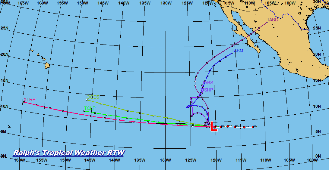
1. Satellite images indicate that a broad area of low pressure has
developed in association with the region of disturbed weather
located a little more than 1000 miles southwest of the southern tip
of the Baja California peninsula. The system is gradually becoming
better organized and environmental conditions appear to be favorable
for some additional development. A tropical depression could form
from this system later today or Wednesday before the disturbance
moves slowly northwestward toward unfavorable upper-level winds
later this week. The next Special Tropical Weather Outlook on this
system will be issued by 11 AM PDT Wednesday, or earlier, if
necessary.
* Formation chance through 48 hours...medium...50 percent.
* Formation chance through 5 days...medium...50 percent.

Forecaster Avila
 

 RALPH'S TROPICAL WEATHER GRAPHICS BELOW

CURRENT TRACK
PREVIOUS TRACK MODEL
 GFS ENSEMBLE
 

FLORIDA WEEKEND FORECAST IS LOOKING WET!

Looks like moisture from the tropics will set in for this weekend.  Latest GFS shows plenty of moisture rising northward from the Caribbean (blue color).  Could be associated with a weak upper level trough.  Could this be a drought relief for parts of Florida?
RTW


TODAYS FORECAST FROM NWS IN MIAMI FLORIDA

22m22 minutes ago
Isolated showers and thunderstorms possible in the interior and west this afternoon for South Florida. Temperatures will warm up into the 90s out west and mid 80s along the east coast metro areas. Chance of rain increases by the end of the week.


EAST PACIFIC STORM INVESTIGATION 90E

ZCZC MIATWOEP ALL
TTAA00 KNHC DDHHMM

Special Tropical Weather Outlook
NWS National Hurricane Center Miami FL
1045 AM PDT Mon May 7 2018

For the eastern North Pacific...east of 140 degrees west longitude:

1. A large area of disturbed weather has formed a little more than
one thousand miles south-southwest of the southern tip of the Baja
California peninsula.  Environmental conditions are forecast to be
marginally favorable for some development during the next day or
two while the disturbance moves generally toward the west-northwest
and northwest.  After that time, upper-level winds are expected to
become less conducive for tropical cyclone formation.  The next
Special Tropical Weather Outlook on this system will be issued by
11 AM PDT Tuesday, or earlier, if necessary.
* Formation chance through 48 hours...low...30 percent.
* Formation chance through 5 days...medium...40 percent.

Forecaster Avila