
Thanks for the help throughout the years to those that have supported RTW since 1999.
Ralph


STORM INVEST 90L
ZCZC MIATWOAT ALL
TTAA00 KNHC DDHHMM CCA

Special Tropical Weather Outlook...Corrected
NWS National Hurricane Center Miami FL
800 AM EDT Wed May 23 2018

Corrected header

For the North Atlantic...Caribbean Sea and the Gulf of Mexico:

1. A broad surface low centered near the coast of northeastern Belize
continues to produce a large area of cloudiness and showers
extending from the northwestern Caribbean Sea across Cuba and into
the Florida Straits.  Little development is expected during the
next couple of days due to strong upper-level winds and proximity to
the Yucatan Peninsula.  However, environmental conditions are then
forecast to become more conducive for development, and a subtropical
or tropical depression could form this weekend over the eastern or
central Gulf of Mexico.  Regardless of development, locally heavy
rainfall is possible across western Cuba and the Cayman Islands
during the next few days, and over much of Florida and the
northern Gulf Coast during the weekend. For more information on the
heavy rain threat, please see products issued by your local weather
office. The next Special Tropical Weather Outlook on this system
will be issued by 800 PM EDT.
* Formation chance through 48 hours...low...near 0 percent.
* Formation chance through 5 days...medium...60 percent.

Forecaster Blake


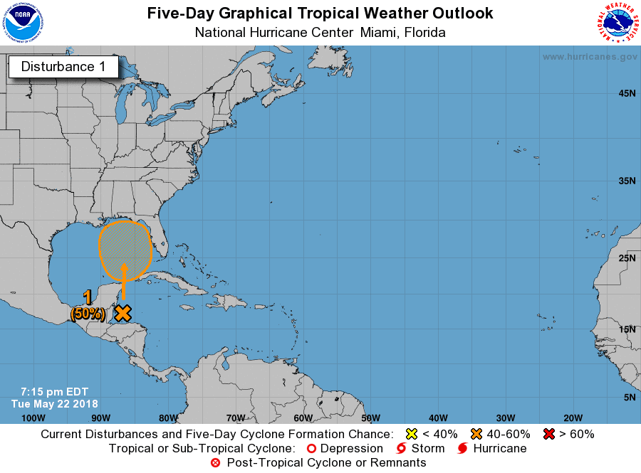
000
ABNT20 KNHC 222314
TWOAT

Special Tropical Weather Outlook
NWS National Hurricane Center Miami FL
715 PM EDT Tue May 22 2018

For the North Atlantic...Caribbean Sea and the Gulf of Mexico:

A broad surface low centered just east of Belize is producing a
large area of cloudiness and showers extending from the northwestern
Caribbean Sea across Cuba and into the Florida peninsula.  Little
development is expected during the next couple of days due to strong
upper-level winds and proximity to the Yucatan Peninsula of Mexico.
However, gradual subtropical or tropical development is possible
late this week while the system moves slowly into the central or
eastern Gulf of Mexico.  Regardless of development, locally heavy
rainfall is possible across western Cuba, the Cayman Islands, and
much of Florida during the next several days.  For more information
on the heavy rain threat, please see products issued by your local
weather office. The next Special Tropical Weather Outlook on this
system will be issued by 800 AM EDT on Wednesday.
* Formation chance through 48 hours...low...near 0 percent.
* Formation chance through 5 days...medium...50 percent.

$$
Forecaster Beven


ZCZC MIATWOAT ALL
TTAA00 KNHC DDHHMM

Special Tropical Weather Outlook
NWS National Hurricane Center Miami FL
745 AM EDT Tue May 22 2018

For the North Atlantic...Caribbean Sea and the Gulf of Mexico:

1. A broad surface low centered just east of Belize is producing a
large area of cloudiness and showers extending from the northwestern
Caribbean Sea across Cuba into the Florida peninsula.  While strong
upper-level winds and dry air aloft are expected to limit
organization during the next couple of days, some gradual
subtropical or tropical development is possible late this week while
the system moves slowly northward into the central or eastern Gulf
of Mexico. Regardless of development, locally heavy rainfall is
possible across western Cuba, the Cayman Islands, and much of
Florida during the next several days.  For more information on the
heavy rain threat, please see products issued by your local weather
office. The next Special Tropical Weather Outlook on this system
will be issued by 800 PM EDT.
* Formation chance through 48 hours...low...near 0 percent.
* Formation chance through 5 days...medium...40 percent.

Forecaster Blake


000
ABNT20 KNHC 212331
TWOAT

Special Tropical Weather Outlook
NWS National Hurricane Center Miami FL
730 PM EDT Mon May 21 2018

For the North Atlantic...Caribbean Sea and the Gulf of Mexico:

A broad surface low pressure area has formed over the northwestern
Caribbean Sea a couple of hundred miles east of the coast of Belize.
This low and an upper-level trough are producing widespread
cloudiness and showers extending from the northwestern Caribbean
Sea across Cuba and the Florida peninsula.  While environmental
conditions are expected to be unfavorable for development during
the next couple of days, some gradual subtropical or tropical
development is possible later this week while the system moves
slowly northward into the central or eastern Gulf of Mexico.
Regardless of development, locally heavy rainfall is possible
across western Cuba and much of Florida during the next several
days.  For more information on the heavy rain threat, please see
products issued by your local weather office. The next Special
Tropical Weather Outlook on this system will be issued by 800 AM
EDT on Tuesday.
* Formation chance through 48 hours...low...near 0 percent.
* Formation chance through 5 days...medium...40 percent.

$$
Forecaster Cangialosi


