Thursday, July 26, 2018

TROPIC OUTLOOK JULY 26. 2018... 0300 PM EDT

National Hurricane Center
107 
AXNT20 KNHC 261717
TWDAT 

Tropical Weather Discussion
NWS National Hurricane Center Miami FL
117 PM EDT Thu Jul 26 2018

Tropical Weather Discussion for North America, Central America
Gulf of Mexico, Caribbean Sea, northern sections of South
America, and Atlantic Ocean to the African coast from the
Equator to 32N. The following information is based on satellite
imagery, weather observations, radar and meteorological analysis.

Based on 1200 UTC surface analysis and satellite imagery through 
1600 UTC.

...TROPICAL WAVES...

A tropical wave is near the Cabo Verde Islands with an axis
extending from 18N22W to 05N23W, moving westward at 10 to 15 kt.
This wave is well defined with a notable 700 mb trough in model
guidance. Deep moisture interacting with the wave S of 10N
is supporting scattered moderate convection from 07N to 10N 
between 21W and 26W. The remainder of the wave environment lacks 
convection due in part to the presence of Saharan dry air and 
dust.

A tropical wave is over central Atlantic with an axis extending
from 20N37W to 05N38W, moving westward at 10 to 15 kt. This wave
is associated with a well defined trough at 700 mb. A large area 
of Saharan dry air and dust continue to hinder convection from 
developing around this wave.

A tropical wave is over the central Atlantic with an axis
extending from 11N52W to 06N52W, moving westward at 10 to 15 kt.
Scattered thunderstorms are S of 13N within 90 nm of the wave
axis. Strong deep layer wind shear and Saharan dry air and dust 
are hindering deep convection across the northern portion of the 
wave.

A tropical wave over the central Caribbean has been re-analyzed as
of 1500 UTC along 71W based off both long term satellite imagery
and 700 mb model field data. Precipitable water satellite imagery
shows a very dry environment across the central Caribbean, which 
along with strong deep layer wind shear are hindering convection S
of Hispaniola.

...MONSOON TROUGH/ITCZ...

The monsoon trough axis extends from the coast of Africa near 
12N16W to 07N33W. The ITCZ extends from 07N39W to 09N51W...then 
resumes W of a tropical wave near 09N54W and continues to 10N60W.
Aside from convection associated with the tropical waves, 
scattered moderate convection is from 06N to 11N E of 20W, and 
within 180 nm N of the ITCZ axis between 54W and 60W.

...DISCUSSION...

GULF OF MEXICO...

An upper level trough prevails across the E Gulf with its base 
extending SW from central Florida to the Bay of Campeche. This 
trough supports a weakening stationary front that extends across 
the Florida Panhandle to SE Louisiana. It also supports a surface
trough that extends from the Florida Big Bend SW to 26N89W. 
Numerous showers and tstms are within 120 nm SE of this trough. 
The front is transitioning to a surface trough. Both troughs are
expected to lift north through tonight. Otherwise, the Atlantic 
subtropical ridge covers the remainder of the SE Gulf and will 
continue to build northwestward across the remainder of the basin
through the weekend. Light to gentle variable flow will dominate 
the basin during this time period.

CARIBBEAN SEA...

A weak upper level low centered near Jamaica along with shallow 
moisture in the NW Caribbean support scattered showers and tstms N
of 17N between 75W and 83W. In the SW basin, the monsoon trough 
supports numerous showers and tstms S of 11N. A tropical wave is 
crossing the central Caribbean waters. Please refer to the 
tropical waves section above for further details. GOES-16 water 
vapor imagery continues to indicate very dry conditions across the
remainder of the basin while enhanced RGB satellite imagery 
indicates a thin layer of Saharan Air Dust moving across the area.
Strong deep layer wind shear is also noted in the E Caribbean. 
These hostile factors are suppressing convection across the 
remainder of the Caribbean basin. A new tropical wave is forecast 
to move across the Lesser Antilles Friday night, with showers and 
thunderstorms beginning to spread across the southern Leeward 
islands starting this evening in advance of the wave.

ATLANTIC OCEAN...

Three tropical waves are moving across the basin. Please refer to
the tropical waves section above for more details. Scattered 
showers and tstms N of 23N W of 75W are being supported by an 
upper trough along the eastern United States that extends across 
the Florida peninsula. This upper trough will prevail through
Friday, enhancing shower and thunderstorm activity over this 
area. Farther east, an upper level low supports a surface trough 
that extends from 31N63W to 28N66W. These features support a broad
area of cloudiness with scattered showers and isolated tstms from
20N to 31N between 62W and 70W. The Atlantic subtropical ridge 
dominates the remainder of the basin being anchored by a 1030 mb 
high centered near 37N54W. Surface ridging will dominate the 
central and eastern Atlantic through the end of the week providing
stable and dry conditions. 

For additional information 
please visit http://www.hurricanes.gov/marine

$$
Latto
------------------------------------------------------------------
Sahara dust continues to suppress tropical cyclone formation in the Atlantic...RTW

TROPICAL WEATHER OUTLOOK JULY 26, 2018...0955 AM EDT

National Hurricane Center
256 
AXNT20 KNHC 261203
TWDAT

Tropical Weather Discussion
NWS National Hurricane Center Miami FL
803 AM EDT Thu Jul 26 2018

Tropical Weather Discussion for North America, Central America
Gulf of Mexico, Caribbean Sea, northern sections of South
America, and Atlantic Ocean to the African coast from the
Equator to 32N. The following information is based on satellite
imagery, weather observations, radar and meteorological analysis.

Based on 0600 UTC surface analysis and satellite imagery through 
1100 UTC.

...TROPICAL WAVES...

A tropical wave is near the Cabo Verde Islands with an axis
extending from 10N21W to 07N21W, moving westward at 10 to 15 kt.
This wave is well defined with a notable 700 mb trough in model
guidance. Deep moisture interacting with the wave S of 12N
is generating scattered moderate convection from 07N to 12N 
between 18W and 24W. The remainder wave environment lacks 
convection due in part to the presence of Saharan dry air and 
dust.

A tropical wave is over central Atlantic with an axis extending
from 20N35W to 07N36W, moving westward at 10 to 15 kt. A large 
area of Saharan dry air and dust continue to hinder convection 
from developing around this wave.

A tropical wave is over the central Atlantic with an axis
extending from 18N49W to 05N50W, moving westward at 10 to 15 kt. 
Strong deep layer wind shear and Saharan dry air and dust are
hindering deep convection at this time.

A tropical wave is over the central Caribbean with an axis 
extending from 21N71W to 11N73W, moving westward at 15 to 20 kt. 
Precipitable water satellite imagery shows a very dry environment 
across the central Caribbean, which along with strong deep layer 
wind shear are hindering convection S of Hispaniola. Only shallow
moisture and middle level diffluence support scattered showers 
and tstms ahead of the wave in the Windward Passage...off SW 
Haiti.

...MONSOON TROUGH/ITCZ...

The monsoon trough axis extends from the coast of Africa near 
12N16W to 09N32W. The ITCZ extends from 09N37W to 08N48W...then 
resumes W of a tropical wave near 09N52W and continues to the 
coast of South America near 09N61W. Aside from convection
associated with the tropical waves, scattered moderate convection
is from 06N to 11N E of 18W, and within 150 nm N of the ITCZ axis
between 52W and 60W.

...DISCUSSION...

GULF OF MEXICO...

An upper level trough prevails across the E Gulf with base
extending SW from central Florida to the Bay of Campeche. This
trough supports a weak stationary front that extends across the 
Florida Panhandle to SW Louisiana. It also supports a surface 
trough that extends from the Florida Big Bend SW to 24N89W. 
Isolated showers and tstms are within 75 nm SE of this trough. 
The trough is forecast to dissipate today while the front lifts 
NE of the area. Otherwise, the Atlantic subtropical ridge covers 
the remainder SE Gulf and will continue to build northwestward 
across the remainder basin through the weekend. Light to gentle 
variable flow will dominate the basin during this time period.

CARIBBEAN SEA...

An upper level low centered near Jamaica along with shallow 
moisture in the NW Caribbean support scattered showers and tstms N
of 17N between 72W and 82W. In the SW basin, the monsoon trough 
supports scattered showers and tstms S of 11N. A tropical wave is
crossing the central Caribbean waters. See the tropical waves 
section above for further details. GOES-16 water vapor imagery 
indicates very dry conditions across the remainder of the basin 
while enhanced RGB satellite imagery indicates a thin layer of 
Saharan Air Dust moving across the area. Strong deep layer wind 
shear is also noted in the E Caribbean. These hostile factors are 
suppressing convection across the remainder of the Caribbean 
basin. A new tropical wave is forecast to move across the Lesser 
Antilles Friday night.

ATLANTIC OCEAN...

Three tropical waves are moving across the basin. Please refer to
the tropical waves section above for more details. Scattered 
showers and tstms are N of the Bahamas W of 76W being supported by
an upper trough along the eastern United States that extends to 
the W Atlc waters. Farther east, an upper level low supports a 
surface trough that extends from 27N62W to 23N67W which is
supporting isolated showers and tstms N of 25N between 61W and 
68W. Otherwise, the Atlantic subtropical ridge dominates the 
remainder of the basin being anchored by a 1031 mb high centered 
near 36N56W. Surface ridging will dominate the central and eastern
Atlantic through the end of the week providing stable and dry 
conditions. 

For additional information 
please visit http://www.hurricanes.gov/marine

$$
Latto
-------------------------------------------------------------------
There are no signs of tropical cyclone formation at this time... RTW
 

Wednesday, July 25, 2018

TROPICAL WEATHER OUTLOOK JULY 25, 2018...0331 PM EDT

National Hurricane Center
479 
AXNT20 KNHC 251717
TWDAT 

Tropical Weather Discussion
NWS National Hurricane Center Miami FL
117 PM EDT Wed Jul 25 2018

Tropical Weather Discussion for North America, Central America
Gulf of Mexico, Caribbean Sea, northern sections of South
America, and Atlantic Ocean to the African coast from the
Equator to 32N. The following information is based on satellite
imagery, weather observations, radar and meteorological analysis.

Based on 1200 UTC surface analysis and satellite imagery through 
1715 UTC.

...TROPICAL WAVES...

A tropical wave is over the far eastern Atlantic west of the Cape
Verde Islands with axis along 34W extending from 05N-19N, moving 
westward at 15-20 kt. A large area of Saharan dry air and dust is 
hindering convective activity from developing at the time.

A tropical wave is over the central Atlantic with axis along 46W 
from 04N-15N, moving westward at 15-20 kt. A large area of 
Saharan dry air and dust is hindering convective activity from 
developing at the time. 

A tropical wave is over the eastern Caribbean with axis along 62W
from 08N- 19N, moving westward at 15 kt. A large area of Saharan 
dry air and dust is hindering convective activity from developing 
at the time.

A tropical wave is over the western Caribbean with axis along 81W
from central Cuba to central Panama, moving westward at 15-20 kt.
Shallow moisture in the northern wave environment along with a 
region of middle to upper level diffluence east of the wave is 
supporting isolated moderate convection off the coasts of E Cuba 
and Jamaica. In addition, scattered moderate convection is over 
the southern portion of the wave along the coasts of Panama and 
Costa Rica S of 11N. 

...MONSOON TROUGH/ITCZ...

The monsoon trough axis extends from the coast of Africa near 
11N15W to 09N20W to 10N34W to 08N37W. The ITCZ extends from 
08N37W to 08N45W. The ITCZ resumes W of a tropical wave near
08N48W and continues to the coast of South America near 07N58W. 
Scattered moderate convection is along the coast of W Africa from 
07N-12N between 13W-21W. 

...DISCUSSION...

GULF OF MEXICO...

An upper level trough is over the NE Gulf of Mexico and N Florida.
This feature supports a 1013 mb surface low near 30N86W. Diffluence
aloft east of the upper level trough is sustaining convection 
over the W Atlantic off the Florida coast, while diffluence to the
south is producing convection over the south central Gulf of 
Mexico. Convection is expected to continue over these areas 
through Thu. The Atlantic subtropical ridge will then extend an 
axis SW across the eastern Gulf. Surface ridging is forecast to 
continue through the weekend, thus providing light to gentle 
variable flow across the basin. Elsewhere, a surface trough will 
move off the Yucatan Peninsula into the Bay of Campeche each 
evening, accompanied by fresh nocturnal winds. Scattered to 
isolated showers are possible in the Bay of Campeche with the 
surface trough.

CARIBBEAN SEA...

Two tropical waves are over the Caribbean. See above. Scattered 
moderate convection is over N Colombia, Panama, and Costa Rica.
Isolated showers are located over waters S of Puerto Rico and 
Hispaniola between 65W and 75W. These showers are being sustained 
by a small region of shallow moisture and diffluence aloft. 
Relatively dry and stable conditions persist elsewhere. Expect 
the surface pressure gradient to support fresh to strong winds in 
the south-central basin through Fri. Elsewhere, stable conditions 
with light to moderate winds are expected. 

ATLANTIC OCEAN...

Two more tropical waves are moving across the basin lacking 
convection due to the presence of the dry air in the Saharan Air 
Layer. Refer to the tropical waves section above for more details.
Scattered moderate convection is across the W Atlantic including 
the northern Bahamas, W of 75W. Farther east, a middle to upper 
level low supports an area of scattered moderate convection from 
22N-28N between 56W-64W. Otherwise, the Atlantic subtropical ridge
dominates the remainder basin being anchored by a 1031 mb high 
centered near 37N55W. 

Expect convection north of the Bahamas through the weekend.
Thesurface pressure gradient between the Atlantic 1031 mb 
subtropical high and the low pressure over the southeast U.S. 
will produce moderate to fresh southerly winds across the waters 
north of 25N and west of 70W including Florida coastal waters 
today. Moderate to fresh winds are also expected south of 22N, 
including approaches to the Windward Passage. Surface ridging 
will dominate the central and eastern Atlantic through the end of
the week providing stable and dry conditions.

For additional information 
please visit http://www.hurricanes.gov/marine

$$
Formosa 
-----------------------------------------------------------------
THE TROPICS REMAIN QUIET FOR NOW...RTW

TROPICAL WEATHER OUTLOOK JULY 25, 2018... 1036 AM EDT

National Hurricane Center
...TROPICAL WAVES...

A tropical wave is over the far eastern Atlantic west of the Cape
Verde Islands with axis along 32W extending from 06N-20N, moving 
westward at 15-20 kt. A large area of Saharan dry air and dust is 
hindering convective activity from developing at the time.

A tropical wave is over the central Atlantic with axis along 45W 
from 06N-15N, moving westward at 15-20 kt. A large area of 
Saharan dry air and dust is hindering convective activity from 
developing at the time. 

A tropical wave is over the Lesser Antilles with axis along 61W 
from 08N-18N, moving westward at 15 kt. A large area of Saharan 
dry air and dust is hindering convective activity from developing 
at the time. 

A tropical wave is over the western Caribbean with axis along 80W
from central Cuba to central Panama, moving westward at 15-20 kt.
Shallow moisture in the northern wave environment along with a 
region of middle to upper level diffluence ahead of the wave is 
supporting isolated moderate convection off the coasts of Cuba 
and Jamaica. In addition, widely scattered moderate convection is
over the southern portion of the wave along the coasts of Panama
and Costa Rica S of 11N. 
------------------------------------------------------------------
All quiet in the tropics...RTW 
 

Tuesday, July 24, 2018

TROPICAL WEATHER OUTLOOK JULY 24, 2018 0611 PM EDT

National Hurricane Center
...TROPICAL WAVES...

A tropical wave is over the Cape Verde Islands with axis 
extending from 06N-20N along 24W, moving W at 15 kt. A large area
of Saharan dust is noted along the wave mainly north of 14N.
Isolated moderate convection is E of the wave axis from 08N-16N 
between 12W-19W. 

A tropical wave is in the eastern Atlantic with axis extending 
from 05N-17N along 37W, moving W at 15 kt. A large area of 
Saharan dust is noted along the wave mainly north of 10N. Widely 
scattered moderate convection is noted where the wave intersects 
the monsoon trough from 08N-10N between 32W-38W.

A tropical wave is in the central Atlantic with axis extending 
from 06N-20N along 55W is moving W at 15 kt. This wave is on the 
leading edge of a large area of Saharan air, inhibiting large 
scale convection at this time.

A tropical wave is in the eastern Caribbean with axis extending 
from 08N-20N along 70W, moving W at 15-20 kt. The wave is 
accompanied by Saharan dry air and dust, inhibiting any 
significant convection. 
------------------------------------------------------------------
The tropics remain quiet for now!  RTW

Wednesday, July 18, 2018

TROPICAL WEATHER OUTLOOK JULY 18, 2018 1038 AM EDT

Updating the tropics lately has been a mission.  Yesterday I was out with a sprain ankle helping my daughter move. Today I did not bring my heavy back pack because of my ankle.  So I am winging the tropical weather outlook from my phone.  So bare with me and after I come back from vacation on July 25 tropical updates and website updates will resume.
RTW

Tropical outlook:
The tropical Atlantic remains suppressed by a hugh surge of Sahara Dry air and dust that extends from the African coast all the way to the Caribbean and Florida.

So far there are three tropical waves across the Atlantic and none are showing signs of tropical cyclone formation at this time. Below you will find NHC surface map and Tropical Tidbit satellite.
RTW


Monday, July 16, 2018

IN THE MEANTIME A BRIEF TROPICAL OUTLOOK

1.  A tropical wave introduced to the surface map between 11 and 10° West over the African continent.  Plenty of Sahara Dust west of this wave being blown off the African coast over the Cabo Verde Islands.

2. Another large axis wave near 40° West is also surrounded by Sahara dust.

3. A short axis wave over Puerto Rico extends southwest over northern Columbia.

4.  A wave across northeast Honduras and Nicaragua.  Sahara dust the Caribbean as well but lite.

Non of the tropical waves are showing signs of organization at this time.
-------------------------------------------------------------------------------------------------------------------------


UPDATE TO DOWN SERVER FROM SITEBUILDER

It seems that they are slowly fixing the problem but the html scripts that I added to get automated satellite image, the text scroller at the top of page, tropical wave symbols on tropical outlook map , the National Hurricane Center website and the Live Radar page is still not working.  I don't want to publish until that is all fixed just in case.  I did that before and I had to enter all html scripts all over.  So lets hope it gets fixed soon.

I will keep you posted!

Ralph's Tropical Weather (RTW)

SITE BUILDER WEB SERVER DOWN!


When it rains it pours!  I updated RTW website this morning but there must of been a problem with the server where my website it uploaded too.  The site editing tool is unavailable and the site is also unavailable for viewing on the web.  So until they fix the problem on there side I am unable to update my website.  Sorry for the inconvenience this is something beyond my control.

Ralph's Tropical Weather (RTW)

Sunday, July 15, 2018

REASON FOR NO UPDATES!

This has been a busy weekend helping my daughter move.  This is why I have not been updating the blog or website.  I will resume regular updates tomorrow July 16, 2018 through Wed July 18 then I will be on vacation July 19-24.  In the meantime you can use links for satellite, and the hurricane center on ralphstropicalweather.com or on the web...RTW

Friday, July 13, 2018

TROPICAL UPDATE JULY 13, 2018... 0401 PM EDT

BERYL (INVEST 95L)
751 
ABNT20 KNHC 131743
TWOAT 

Tropical Weather Outlook
NWS National Hurricane Center Miami FL
200 PM EDT Fri Jul 13 2018

For the North Atlantic...Caribbean Sea and the Gulf of Mexico:

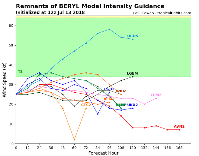
An area of low pressure, associated with the remnants of Beryl, is
located about 250 miles west-northwest of Bermuda.  Although
upper-level winds are at best marginally conducive, this system has
become a little better organized today, and some additional
subtropical or tropical development is possible tonight and Saturday
while the low moves north-northeastward at about 10 mph.  By Sunday,
the system should reach colder water north of the Gulf Stream, where
additional development is unlikely.
* Formation chance through 48 hours...low...30 percent.
* Formation chance through 5 days...low...30 percent.

$$
Forecaster Beven https://www.nhc.noaa.gov/


BERYL STORM INVEST 95L JULY 13, 2018... 1142 AM EDT

BERYL (INVEST 95L)
 
914 
ABNT20 KNHC
31155
TWOAT 

Tropical Weather Outlook
NWS National Hurricane Center Miami FL
800 AM EDT Fri Jul 13 2018

For the North Atlantic...Caribbean Sea and the Gulf of Mexico:

An area of low pressure, associated with the remnants of Beryl, is
located about 300 miles west of Bermuda.  The associated shower and
thunderstorm activity remains disorganized due to strong upper-level
winds.  These winds are expected to become even less conducive for
subtropical or tropical development over the next day or two while
the low moves north-northeastward at about 10 mph, and additional
development will be limited once the low reaches colder waters by
Saturday night or Sunday.
* Formation chance through 48 hours...low...20 percent.
* Formation chance through 5 days...low...20 percent.

$$
Forecaster Beven https://www.nhc.noaa.gov/

Thursday, July 12, 2018

TRACKING THE TROPICS UPDATE JULY 12, 2018...0417 PM EDT

BERYL'S REMNANTS (INVEST 95L
569 
ABNT20 KNHC 121721
TWOAT 

Tropical Weather Outlook
NWS National Hurricane Center Miami FL
200 PM EDT Thu Jul 12 2018

For the North Atlantic...Caribbean Sea and the Gulf of Mexico:

The National Hurricane Center has issued its last advisory on
Post-Tropical Cyclone Chris, located a little over 200 miles
west-southwest of Cape Race, Newfoundland.

An elongated area of showers and thunderstorms associated with the
remnants of Beryl is located about 400 miles west-southwest of
Bermuda.  Little or no development is expected through Friday while
the system moves northeastward.  However, environmental conditions
could become a little more favorable over the weekend when the
disturbance will be moving northward or north-northeastward over the
warm waters of the western Atlantic and interacting with a strong
upper-level trough.
* Formation chance through 48 hours...low...10 percent.
* Formation chance through 5 days...medium...50 percent.

$$
Forecaster Stewart https://www.nhc.noaa.gov/