Wednesday, August 22, 2018

HURRICANE LANE CONTINUES TO MOVE ON TRACK AUG 18, 2018

Replaced forecast map with
Correct latest track.
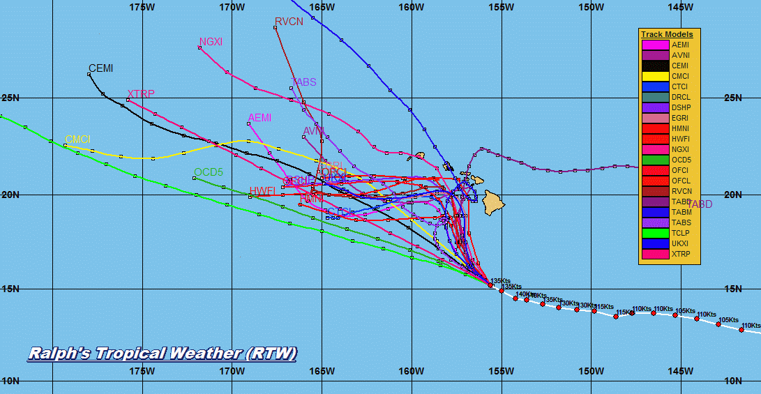
WTPA32 PHFO 222048
TCPCP2
 
BULLETIN
Hurricane Lane Advisory Number  33
NWS Central Pacific Hurricane Center Honolulu HI   EP142018
1100 AM HST Wed Aug 22 2018
 
...HAWAIIAN ISLANDS REMAIN VULNERABLE AS CATEGORY 4 HURRICANE
LANE PASSES SOUTH OF THE BIG ISLAND...
 
 
SUMMARY OF 1100 AM HST...2100 UTC...INFORMATION
-----------------------------------------------
LOCATION...15.5N 155.9W
ABOUT 285 MI...455 KM S OF KAILUA-KONA HAWAII
ABOUT 420 MI...680 KM SSE OF HONOLULU HAWAII
MAXIMUM SUSTAINED WINDS...155 MPH...250 KM/H
PRESENT MOVEMENT...WNW OR 295 DEGREES AT 8 MPH...13 KM/H
MINIMUM CENTRAL PRESSURE...935 MB...27.61 INCHES
 
 
WATCHES AND WARNINGS
--------------------
CHANGES WITH THIS ADVISORY:
 
None.
 
SUMMARY OF WATCHES AND WARNINGS IN EFFECT:
 
A Hurricane Warning is in effect for...
* Hawaii County
* Maui County...including the islands of Maui, Lanai, Molokai and
Kahoolawe
 
A Hurricane Watch is in effect for...
* Oahu
* Kauai County...including the islands of Kauai and Niihau
 
A Hurricane Warning means that hurricane conditions are expected
somewhere within the warning area. A warning is typically issued
36 hours before the anticipated first occurrence of tropical-storm-
force winds, conditions that make outside preparations difficult
or dangerous. Preparations to protect life and property should be
rushed to completion.
 
A Hurricane Watch means that hurricane conditions are possible
within the watch area. A watch is typically issued 48 hours before
the anticipated first occurrence of tropical-storm-force winds,
conditions that make outside preparations difficult or dangerous.
 
Interests in the the Northwestern Hawaiian Islands should monitor
the progress of Hurricane Lane.
 
For storm information specific to your area, please monitor
products issued by the National Weather Service office in
Honolulu Hawaii.
 
 
DISCUSSION AND OUTLOOK
----------------------
At 1100 AM HST (2100 UTC), the eye of Hurricane Lane was located
near latitude 15.5 North, longitude 155.9 West. Lane is moving
toward the west-northwest near 8 mph (13 km/h). A gradual turn
toward the northwest is expected today followed by a more northward
motion on Thursday. A turn back toward the west is expected on
Saturday. On the forecast track, the center of Lane will move very
close to or over the main Hawaiian Islands from Thursday through
Saturday.
 
Maximum sustained winds are near 155 mph (250 km/h) with higher
gusts.  Lane is a category 4 hurricane on the Saffir-Simpson
Hurricane Wind Scale. A steady weakening trend is forecast to begin
today, but Lane is expected to remain a dangerous hurricane as it
approaches the islands.
 
Hurricane-force winds extend outward up to 40 miles (65 km) from the
center and tropical-storm-force winds extend outward up to 140 miles
(220 km).
 
The estimated minimum central pressure is 935 mb (27.61 inches).
 
 
HAZARDS AFFECTING LAND
----------------------
WIND: Tropical storm conditions are expected within the Hurricane
Warning area beginning late tonight into early Thursday morning,
with hurricane conditions expected somewhere within the warning area
on Thursday. Tropical storm conditions are possible within the
Hurricane Watch area beginning Thursday into Thursday night, with
hurricane conditions possible late Thursday night into Friday.
 
RAINFALL: Rainbands from Hurricane Lane are moving ashore on
the Puna and Kau districts. Excessive rainfall associated with Lane
is expected to affect portions of the Hawaiian Islands from late
today into the weekend. This could lead to major flash flooding and
landslides. Lane is expected to produce total rain accumulations of
10 to 15 inches with localized amounts in excess of 20 inches over
the Hawaiian Islands.
 
SURF: Large swells generated by Lane will impact the Hawaiian
Islands, spreading across the island chain today and tonight. 
These swells will produce very large and potentially damaging surf
along exposed west, south and east facing shorelines.
 
 
NEXT ADVISORY
-------------
Next intermediate advisory at 200 PM HST.
Next complete advisory at 500 PM HST.
 
$$
Forecaster R Ballard
http://www.prh.noaa.gov/cphc/tcpages/?product=5day_cone_with_line&stormid=EP142018


TROPICAL WEATHER OUTLOOK AUG 22, 2018... 0429 PM EDT

TROPICAL WEATHER DISCUSSION BY NHC
093 
AXNT20 KNHC 221805
TWDAT 

Tropical Weather Discussion
NWS National Hurricane Center Miami FL
205 PM EDT Wed Aug 22 2018

Tropical Weather Discussion for North America, Central America
Gulf of Mexico, Caribbean Sea, northern sections of South
America, and Atlantic Ocean to the African coast from the
Equator to 32N. The following information is based on satellite
imagery, weather observations, radar and meteorological analysis.

Based on 1200 UTC surface analysis and satellite imagery through 
1745 UTC.

...TROPICAL WAVES...

A far eastern Atlantic tropical wave has its axis along 25W/26W 
from 05N-20N, moving westward at 10-15 kt. The wave is embedded 
within a very dry and stable environment inhibiting convection at 
this time. Only isolated weak showers and thunderstorms are seen
within 120-180 nm east of the wave from 10N to 11N.

A central Atlantic tropical wave has its axis extending along 45W
from 05N-19N, moving westward at 10-15 kt. This wave is also 
embedded within a very dry and stable environment caused by 
Saharan Air Layer outbreak of the past several days that is 
spreading westward across the central and eastern Atlantic. 
Scattered moderate convection is within 120 nm east of the wave 
from 08N to 10N. Isolated showers are within 180 nm east of
the wave from 14N to 19N.

An eastern Caribbean Sea tropical wave has its axis along 66W
south of 19N to well inland Venezuela. It is moving westward near
10-15 kt. Scattered showers and isolated thunderstorms are
increasing east of the wave from 21N to 16N.

A central Caribbean tropical wave has its axis along 76W/77W from 
09N to 20N, moving westward near 15 kt. Previous deep convection 
with this wave has dissipated. Only isolated showers and
thunderstorms are see within 120 nm east of the wave from 18N 
to 20N.

The tropical wave previously along 92W has moved into the eastern 
Pacific. Please refer to the eastern Pacific Tropical Weather
Discussion for details on this wave.

...MONSOON TROUGH/ITCZ...

The monsoon trough axis extends from the African coast near 
14N16W to 10N23W to 09N35W to 09N44W. The ITCZ axis begins at 
08N46W and continues to 10N55W to 10N61W. Scattered moderate 
convection is within 120 nm north of the ITCZ axis between 45W 
and 55W, and north of the monsoon trough within 30 nm of 11N39W.

...DISCUSSION...

GULF OF MEXICO...

High pressure of 1020 mb is analyzed near 26N94w as of 15Z, while 
a surface trough extends from southeastern Georgia southwestward
to the northeastern gulf and continues to near 27N91W. The 
nocturnal Yucatan Peninsula trough has moved across the 
southwestern gulf during the late night and early morning hours, 
and is analyzed from near 21N96W to 18N94W as of 15Z. The present 
pressure gradient across the gulf generally supports light to 
gentle winds throughout, except for gentle to moderate winds south
of 26N and relatively low seas of 1 to 3 ft. Scattered showers 
and thunderstorms are observed over the far southwest section of 
the gulf south of 21N and west of 94W in association with the 
nocturnal trough that moved offshore the Yucatan Peninsula during 
the overnight hours. Other scattered showers and thunderstorm 
activity continues to increase over the north-central gulf in 
association with the aforementioned surface trough, with further 
support from an upper-level trough that is dropping southward 
across the norther gulf section. The activity over the far 
southwest is expected to weaken during the afternoon. It should 
then re-develop  tonight and Thu night as the surface trough 
again moves across those same waters. The activity over the north-
central gulf should continue to increase through this afternoon 
and into the evening hours. Otherwise, relatively weak high 
pressure ridging will remain across the northern gulf waters, with
the associated gradient producing gentle to moderate anticyclonic
flow through Fri.

CARIBBEAN SEA...

Two tropical waves are moving across the basin. Refer to the
section above for details. An upper level trough extends from
eastern Cuba southwestward to just east of northeastern Honduras.
Water vapor imagery indicates plentiful deep layer moisture along
and to the northwest of this trough, and it is where isolated 
showers and thunderstorms are occurring. Scattered moderate 
isolated strong convection has increased over the far southwestern
Caribbean south of 11N between 77W and 82W mainly due to low-level
wind speed convergence, with the added factor of the eastern 
segment of the eastern Pacific monsoon trough that stretches east-
northeastward to the far southwestern Caribbean along 09N and to 
the typical climatological low found over northwestern Colombia 
presently located just offshore that coast at 09N76W.

A slighter tighter pressure gradient behind the tropical wave 
along 77W will help induce strong to near gale force northeast to 
east trade winds over the south-central Caribbean waters off the 
coast of Colombia and across the Gulf of Venezuela tonight. The 
strong trades are forecast to reach northward to 15N. Moderate to 
fresh trades will continue elsewhere through Fri as little overall
changes are expected with the present synoptic set-up through 
Fri.

ATLANTIC OCEAN...

Two tropical waves are moving across the basin. Refer to the 
section above for details. A surface trough is analyzed from 
29N61W to 21N68W. A shear axis is evident by model and satellite 
winds to be situated northwest of the trough from 32N65W to 25N70W
to east-central Cuba. Satellite imagery shows increasing scattered 
showers and thunderstorms within 180 nm to the northwest of the 
trough between 65W and 69W. Isolated showers and thunderstorms 
are seen over the western portion of the basin west of about 75W.
This activity as well as that to the northwest of the surface
trough are expected to last through tonight and into Thu. Another
trough moving westward around 15 kt is along 52W from 17N to 30N.
No deep convection is noted with this trough, only isolated 
showers within 120 nm east of the trough from 21N to 26N. A 1025 
mb high center is analyzed north of 31N and extends a ridge across
the remainder of the basin. Saharan dust and associated dry air, 
although not as dense as in previous days, is noted mainly east of
about 60W on GOES-16 GEO color dust imagery. The dust is keeping 
convection rather limited, to non-existent, outside across the 
eastern and central Atlantic waters, except as described above 
near the the ITCZ region.

For additional information please visit 
http://www.hurricanes.gov/marine

$$
Aguirre 
https://www.nhc.noaa.gov/
------------------------------------------------------------------
NHC is now also monitoring a future wave that is forecast to move
off the the African coast by tomorrow then track west over the 
central Atlantic where conditions could become more favorable for
tropical cyclone formation by next week...RTW 


TROPICAL WEATHER OUTLOOK AUG 22, 2018... 1205 PM EDT

TROPICAL WEATHER DISCUSSION BY NHC
391 
AXNT20 KNHC 221205
TWDAT

Tropical Weather Discussion
NWS National Hurricane Center Miami FL
805 AM EDT Wed Aug 22 2018

Tropical Weather Discussion for North America, Central America
Gulf of Mexico, Caribbean Sea, northern sections of South
America, and Atlantic Ocean to the African coast from the
Equator to 32N. The following information is based on satellite
imagery, weather observations, radar and meteorological analysis.

Based 0600 UTC surface analysis and satellite imagery through 
1145 UTC.

...TROPICAL WAVES...

A far eastern Atlantic tropical wave has its axis along 24W/25W 
from 05N-20N, moving westward at 10-15 kt. The wave is embedded 
within a very dry and stable environment inhibiting convection at 
this time. 

A central Atlantic tropical wave has its axis extending along 44W
from 05N-19N, moving westward at 10-15 kt. This wave is also 
embedded within a very dry and stable environment caused by 
Saharan Air Layer outbreak migrating westward across the central 
and eastern Atlantic. Isolated showers and thunderstorms are
within 120 nm either side of the wave from 09N to 11N.

An eastern Caribbean Sea tropical wave has its axis along 64W 
from 07N-19N, moving westward near 10-15 kt. Scattered showers
and isolated thunderstorms are east of the wave from 11N to 13N.

A central Caribbean tropical wave has its axis along 74W/75W from
09N to 20N, moving westward near 15 kt. Scattered moderate 
convection is between eastern Cuba and Jamaica, and over some 
sections of northern Colombia.

The tropical wave that move inland the Yucatan Peninsula yesterday
is approaching 92W, with its northern extent reaching near 20N. It 
is moving westward near 15 kt. Previous numerous showers and
thunderstorms observed over the western Yucatan Peninsula have 
diminished to isolated showers and thunderstorms.

...MONSOON TROUGH/ITCZ...

The monsoon trough axis extends from the African coast near 
17N16W to 11N24W to 10N34W to 06N42W. The ITCZ axis begins at 
06N45W to 08N53W to 09N61W. Scattered moderate convection is 
within 180 nm north of the ITCZ axis between 46W and 53W. Isolated
moderate convection is within 120 nm north of the monsoon trough 
axis between 29W and 34W.

...DISCUSSION...

GULF OF MEXICO...

Weak ridging extends across the northern Gulf of Mexico along  
26N anchored by a 1019 mb high centered near 26N92W. This is 
maintaining light to gentle breezes and 1 to 3 ft seas. Gentle to 
moderate easterly flow is noted elsewhere south of the ridge. 
Scattered showers and thunderstorms are observed over the far 
southwest section of the gulf south of 21N and west of 94W in 
association with a trough that moved offshore the Yucatan 
Peninsula during the overnight hours. This activity is expected
to remain active during the morning before weakening during 
the afternoon. It should then reform tonight and Thu night 
as the surface trough again moves across those same waters.
Relatively weak high pressure ridging will remain across the 
northern gulf waters, with the associated gradient producing 
gentle to moderate anticyclonic flow through Fri.

CARIBBEAN SEA...

Two tropical waves are moving across the basin. Refer to the
section above for details. An upper level trough extends across
the west Caribbean enhancing convection across Cuba and adjacent
waters north of 18N and west of 75W. The pressure gradient across
the area will maintain fresh to strong winds over the south 
central Caribbean off the coast of Colombia and across the Gulf of
Venezuela through Thursday. Moderate to fresh trades will 
continue elsewhere through this period also. Little change is 
expected with the present synoptic set-up through Fri.

ATLANTIC OCEAN...

Over the western Atlantic, a surface trough is analyzed from near
28N78W to 25N79W. Isolated showers and thunderstorms are noted 
near this trough affecting the northern Bahamas. Two tropical 
waves are moving across the basin. Refer to the section above for 
details. Another trough extends along 51W from 21N to 30N. No deep
convection is noted with this trough. A 1025 mb high center is 
analyzed north of 31N and extends a ridge across the remainder of 
the basin. The trough extending across the central Bahamas will 
continue westward during today. Another trough extends from 28N61W
to 21N67W. Scattered showers and thunderstorms are seen from 24N
to 28N between 62W and 70W. Expect foe this activity to continue 
through tonight. Saharan dust and associated dry air, as also 
mentioned above under Tropical Waves, is noted mainly east of 
about 60W on GOES-16 Saharan Air Layer animation is inhibiting 
convection from developing across the eastern and central Atlantic
waters.

For additional information please visit 
http://www.hurricanes.gov/marine

$$
Aguirre 
https://www.nhc.noaa.gov/ 
-------------------------------------------------------------------
...Although  nothing is showing at this time. I am monitoring 40°- 30° West 
for tropical cyclone formation in the coming days All remains quiet for now!...
RTW 
 

HURRICAN LANE SLOWLY MAKING THAT TURN TOWARD THE HAWAIIN ISLAND AUG 22, 2018


POWERFUL HURRICANE LANE MOVING WEST NORTHWESTWARD TOWARD THE MAIN HAWAIIAN ISLANDS

WTPA32 PHFO 221155
TCPCP2
 
BULLETIN
Hurricane Lane Intermediate Advisory Number 31A
NWS Central Pacific Hurricane Center Honolulu HI   EP142018
200 AM HST Wed Aug 22 2018
 
...POWERFUL HURRICANE LANE MOVING WEST NORTHWESTWARD TOWARD THE
MAIN HAWAIIAN ISLANDS...
 
 
SUMMARY OF 200 AM HST...1200 UTC...INFORMATION
----------------------------------------------
LOCATION...14.9N 155.0W
ABOUT 335 MI...540 KM S OF KAILUA-KONA HAWAII
ABOUT 480 MI...770 KM SSE OF HONOLULU HAWAII
MAXIMUM SUSTAINED WINDS...160 MPH...260 KM/H
PRESENT MOVEMENT...WNW OR 290 DEGREES AT 9 MPH...15 KM/H
MINIMUM CENTRAL PRESSURE...935 MB...27.61 INCHES
 
 
WATCHES AND WARNINGS
--------------------
CHANGES WITH THIS ADVISORY:
 
None.
 
SUMMARY OF WATCHES AND WARNINGS IN EFFECT:
 
A Hurricane Warning is in effect for...
* Hawaii County
 
A Hurricane Watch is in effect for...
* Maui County...including the islands of Maui, Lanai, Molokai and
Kahoolawe
* Oahu
 
A Hurricane Warning means that hurricane conditions are expected
somewhere within the warning area. A warning is typically issued
36 hours before the anticipated first occurrence of tropical-storm-
force winds, conditions that make outside preparations difficult
or dangerous. Preparations to protect life and property should be
rushed to completion.
 
A Hurricane Watch means that hurricane conditions are possible
within the watch area. A watch is typically issued 48 hours before
the anticipated first occurrence of tropical-storm-force winds,
conditions that make outside preparations difficult or dangerous.
 
Interests elsewhere in the main Hawaiian Islands, and across the
Northwestern Hawaiian Islands, should continue to closely monitor
the progress of Hurricane Lane. Additional Tropical Storm or
Hurricane Watches or Warnings may be issued tonight or Wednesday.
 
For storm information specific to your area, please monitor
products issued by the National Weather Service office in
Honolulu Hawaii.
 
 
DISCUSSION AND OUTLOOK
----------------------
At 200 AM HST (1200 UTC), the center of Hurricane Lane was located
near latitude 14.9 North, longitude 155.0 West. Lane is moving
toward the west-northwest near 9 mph (15 km/h) and this motion is
expected to continue tonight. A turn toward the northwest is
expected later today, followed by a turn to the north-northwest on
Thursday. On the forecast track, the center of Lane will move very
close to or over the main Hawaiian Islands from Thursday through
Saturday.
 
Maximum sustained winds are near 160 mph (260 km/h) with higher
gusts.  Lane is a category 5 hurricane on the Saffir-Simpson
Hurricane Wind Scale.  Slow weakening is forecast during the next 48
hours, but Lane is forecast to remain a dangerous hurricane as it
draws closer to the Hawaiian Islands.
 
Hurricane-force winds extend outward up to 40 miles (65 km) from
the center and tropical-storm-force winds extend outward up to 140
miles (220 km).
 
The estimated minimum central pressure is 935 mb (27.61 inches).
 
 
HAZARDS AFFECTING LAND
----------------------
WIND: Tropical storm conditions are expected within the
Hurricane Warning area beginning late tonight into
early Thursday morning, with hurricane conditions expected
somewhere within the warning area on Thursday. Tropical storm
conditions are possible within the Hurricane Watch area beginning
Thursday into Thursday night, with hurricane conditions possible
late Thursday night into Friday.
 
RAINFALL: Excessive rainfall associated with Lane is expected
to affect portions of the Hawaiian Islands from late today
into the weekend, leading to flash flooding and landslides. Lane is
expected to produce total rain accumulations of 10 to 15 inches with
isolated amounts greater than 20 inches over the Hawaiian Islands.
 
SURF: Large swells generated by Lane will impact the Hawaiian
Islands, beginning this morning on the Big Island, spreading
across the remainder of the island chain on today. These
swells will produce large and potentially damaging surf along
exposed west, south and east facing shorelines.
 
 
NEXT ADVISORY
-------------
Next complete advisory at 500 AM HST.
 
$$
Forecaster Powell
http://www.prh.noaa.gov/cphc/tcpages/?storm=Lane 
-------------------------------------------------------------------


Tuesday, August 21, 2018

TROPICAL WEATHER OUTLOOK AUG 21, 2018...0327 PM EDT

TROPICAL WEATHER DISCUSSION BY NHC
116 
AXNT20 KNHC 211803
TWDAT 

Tropical Weather Discussion
NWS National Hurricane Center Miami FL
203 PM EDT Tue Aug 21 2018

Tropical Weather Discussion for North America, Central America
Gulf of Mexico, Caribbean Sea, northern sections of South
America, and Atlantic Ocean to the African coast from the
Equator to 32N. The following information is based on satellite
imagery, weather observations, radar and meteorological analysis.

Based on 1200 UTC surface analysis and satellite imagery through
1745 UTC.

...TROPICAL WAVES...

A tropical wave is just inland to just offshore the coast of 
Africa with its axis near 17W, moving westward at 10-15 kt. The 
wave is embedded within a very dry and stable environment. Only 
isolated moderate convection is occurring within 180 nm east of 
the wave axis from 11N to 14N.

A central Atlantic tropical wave has its axis extending from 
05N37W to 13N38W to 19N37W, moving westward at 10-15 kt. This wave 
is also embedded within a very dry and stable environment caused
by Saharan Air Layer outbreak migrating westward across the
central and eastern Atlantic. Only isolated moderate convection 
is noted within 60 nm either side of the wave axis from 10N to
11.5N.

A tropical wave over the eastern Caribbean has its axis from 
well inland Venezuela north-northeastward to 15N65W and to the
proximity of the Virgin Islands. It is moving westward near 
16 kt. Scattered moderate convection trails the wave from 09N
to 11N east to near 58W. 

A western Caribbean tropical wave has its axis extending along 
85W/86W and south of 21N, moving westward near 15 kt. Only 
isolated showers and thunderstorms are noted within 60 nm east of 
the wave.

...MONSOON TROUGH/ITCZ...

The monsoon trough axis extends from coast of Senegal near 14N16W
to 10N23W to 09N31W and to 09N41W, where latest scatterometer data 
indicates that the  ITCZ axis begins and continues to 09N50W to 
09N60W. No significant convection is noted. Only isolated showers 
and thunderstorms are seen within 120 nm north of axis between 43W
and 48W.

...DISCUSSION...

GULF OF MEXICO...

Weak ridging reaches across the northern Gulf of Mexico along
roughly 27N, maintaining light to gentle breezes and 1 to 3 ft
seas. Gentle to moderate easterly flow is noted elsewhere south 
of the ridge. Latest NWS mosaic radar display shows isolated
showers and thunderstorms across much of the eastern part of the 
gulf, mainly due to a weak trough over that area. Scattered
showers and thunderstorms are observed over the far southwest 
section of the gulf in association with the Yucatan Peninsula 
trough that typically moves offshore across the southwestern gulf
late at night and into the morning hours, with the added factor 
of an upper-level low located just east of the coast of Mexico at 
22N97W. Expect for this convective activity to remain active 
through tonight. Otherwise, high pressure ridging will remain 
across the northern gulf waters, with the associated gradient 
producing gentle to moderate anticyclonic flow through Thu.

CARIBBEAN SEA...

The pressure gradient across the area will maintain fresh to 
strong winds over the south central Caribbean off the coast of 
Colombia and across the Gulf of Venezuela through Thu. Moderate
to fresh trades will continue elsewhere through Thu. 

The tropical wave along 85W/86W will move across the rest of the 
western Caribbean this evening before moving inland Central
America. The tropical wave along 65W will move across the rest
of the eastern Caribbean  through Wed night and enter the eastern
part of the central Caribbean Thu.

ATLANTIC OCEAN...

Over the western Atlantic, a surface trough is analyzed from near
30N74W to the central Bahamas. An upper-level trough extends from
an upper-level low at 31N66W to the central Bahamas, and to 
central Cuba as a shear axis. Another trough extends from 32N59W 
to 27N68W, and another one extends from near 32N45W to 28N50W. A 
small surface trough extends from near 31N54W to 28N56W. With
these features in place along with a moist and unstable
environment, the result is scattered shower and thunderstorm
activity over the waters north of 24N between 60W and 75W, with 
the most concentrated activity observed north of 27N and 
between 70W and 76W. Isolated showers and thunderstorms are 
elsewhere west of 58W. A 1025 mb high center is analyzed north of
these troughs at 32.5N59W, with a ridge extending westward to
Bermuda, and southwestward from there to east-central Florida 
High pressure ridging will continue over the basin through the 
next several days. The trough extending across the central Bahamas
will continue westward through this evening. The aforementioned 
shower and thunderstorm activity is forecast to persist through 
Wed.

Over the eastern part of the basin, a 1028 mb high is centered 
near 34N42W, supporting generally moderate north to northeast 
winds north of 20N. Saharan dust and associated dry air, as also
mentioned above under Tropical Waves, is noted mainly east of 
about 56W on GOES-16 Saharan Air Layer animation is inhibiting 
convection from developing across the eastern and central Atlantic
waters.

For additional information please visit 
http://www.hurricanes.gov/marine

$$
Aguirre 
https://www.nhc.noaa.gov/ 
------------------------------------------------------------------
QUIET....QUIET TROPICAL ATLANTIC!


MAJOR HURRICANE LANE IN THE CENTRAL PACIFIC AUG 21, 2018

CENTRAL PACIFIC HURRICANE LANE
WTPA32 PHFO 211757
TCPCP2
 
BULLETIN
Hurricane Lane Intermediate Advisory Number 27A
NWS Central Pacific Hurricane Center Honolulu HI   EP142018
800 AM HST Tue Aug 21 2018
 
...MAJOR HURRICANE LANE MOVING WEST...EXPECTED TO TURN 
TOWARD THE HAWAIIAN ISLANDS ON WEDNESDAY...
 
 
SUMMARY OF 800 AM HST...1800 UTC...INFORMATION
----------------------------------------------
LOCATION...14.1N 152.6W
ABOUT 450 MI...725 KM SSE OF KAILUA-KONA HAWAII
ABOUT 605 MI...975 KM SE OF HONOLULU HAWAII
MAXIMUM SUSTAINED WINDS...155 MPH...250 KM/H
PRESENT MOVEMENT...W OR 280 DEGREES AT 9 MPH...14 KM/H
MINIMUM CENTRAL PRESSURE...940 MB...27.76 INCHES
 
 
WATCHES AND WARNINGS
--------------------
CHANGES WITH THIS ADVISORY:
 
None.
 
SUMMARY OF WATCHES AND WARNINGS IN EFFECT:
 
A Hurricane Watch is in effect for...
*Maui County...including the islands of Maui, Lanai, Molokai and
Kahoolawe
*Hawaii County
 
A Hurricane Watch means that hurricane conditions are possible
within the watch area. A watch is typically issued 48 hours before
the anticipated first occurrence of tropical-storm-force winds,
conditions that make outside preparations difficult or dangerous.
 
Interests elsewhere in the main Hawaiian Islands, and across the
Northwestern Hawaiian Islands, should continue to closely monitor
the progress of Hurricane Lane. Additional Tropical Storm or
Hurricane Watches will likely be issued later today or tonight.
 
For storm information specific to your area, please monitor
products issued by the National Weather Service office in
Honolulu Hawaii.
 
 
DISCUSSION AND OUTLOOK
----------------------
At 800 AM HST (1800 UTC), the eye of Hurricane Lane was located by
U.S. Air Force Reserve Hurricane Hunter aircraft near latitude 14.1
North, longitude 152.6 West. Lane is moving toward the west near 
9 mph (14 km/h) and this general motion is expected to continue
through tonight, with a slight decrease in forward speed. A turn
toward the northwest is expected Wednesday into Thursday. On the
forecast track, the center of Lane will pass close to Hawaii and
Maui Counties on Thursday and Thursday night.
 
Maximum sustained winds have increased to near 155 mph (250
km/h) with higher gusts.  Lane remains a powerful Category 4
hurricane on the Saffir-Simpson Hurricane Wind Scale. Slight
weakening is expected during the next couple of days, but Lane is
forecast to remain a dangerous hurricane as it draws closer to the
Hawaiian Islands.
 
Hurricane-force winds extend outward up to 40 miles (65 km) from
the center and tropical-storm-force winds extend outward up to 140
miles (220 km).
 
The minimum central pressure as recently measured by the hurricane
hunter aircraft is 940 mb (27.76 inches).
 
 
HAZARDS AFFECTING LAND
----------------------
WIND: Hurricane conditions are possible within the Hurricane Watch
area on Thursday.
 
RAINFALL: Excessive rainfall associated with Lane is expected
to affect portions of the Hawaiian Islands from Wednesday into the
weekend, leading to flash flooding and landslides. Lane is expected
to produce total rain accumulations of 10 to 15 inches with isolated
maximum amounts of 20 inches over the Hawaiian Islands.
 
SURF: Large swells generated by Lane will impact the Hawaiian
Islands this week. These swells will produce large and potentially
damaging surf along exposed south and west facing shorelines.
 
 
NEXT ADVISORY
-------------
Next complete advisory at 1100 AM HST.
 
$$
Forecaster Jacobson
http://www.prh.noaa.gov/cphc/tcpages/?storm=Lane 
---------------------------------------------------------------------


TROPICAL WEATHER OUTLOOK AUG 21, 2018... 1006 AM EDT

TROPICAL WEATHER DISCUSSION BY NHC
452 
AXNT20 KNHC 211205
TWDAT 

Tropical Weather Discussion
NWS National Hurricane Center Miami FL
805 AM EDT Tue Aug 21 2018

Tropical Weather Discussion for North America, Central America
Gulf of Mexico, Caribbean Sea, northern sections of South
America, and Atlantic Ocean to the African coast from the
Equator to 32N. The following information is based on satellite
imagery, weather observations, radar and meteorological analysis.

Based on 0600 UTC surface analysis and satellite imagery through 
1145 UTC.

...TROPICAL WAVES...

An eastern Atlantic tropical wave has its axis extending from 
05N36W to 13N36W to 19N54W, moving westward at 10-15 kt. 
Scattered moderate convection is noted from 08N to 10N between 25W
and 32W.

A tropical wave over the eastern Caribbean has its axis along
63W/64W south of 19N, moving westward at 15 to 20 kt. Scattered 
moderate convection trails the wave within 30 nm of a line from 
11N59W to 11N62W.

A western Caribbean tropical wave has its axis extending along 83W 
and south of 20N, moving westward at 10-15 kt. Only isolated
showers and thunderstorms are noted within 60 nm east of the wave.

...MONSOON TROUGH/ITCZ...

The monsoon trough axis extends from coast of Senegal near 14N16W
to 10N20W, then to 08N40W. The intertropical convergence zone
continues westward to the mouth of the Orinoco River near 09N61W.
No significant convection is noted.

...DISCUSSION...

GULF OF MEXICO...

Weak ridging reaches across the northern Gulf of Mexico along
roughly 27N, maintaining light to gentle breezes and 1 to 3 ft
seas. Gentle to moderate easterly flow is noted elsewhere south 
of the ridge. Latest NWS mosaic radar display shows isolated
showers and thunderstorms across much of the eastern part of the 
gulf, mainly due to a weak trough over that area. Scattered to 
numerous showers and thunderstorms are active along the coast of 
Mexico in the far southwest Gulf, related to the normal 
evening/overnight trough that sets up off Yucatan and moves 
westward, but also largely enhanced by an upper low centered over 
the southwest Gulf.

The Yucatan surface trough will persist each afternoon, then 
drift westward across the southwest gulf waters during the 
overnight hours accompanied by a fresh east to southeast wind 
shift with the trough dissipating along 96W during the late 
mornings. Otherwise, high pressure ridging will remain 
across the northern gulf waters, with the associated gradient
producing gentle to moderate anticyclonic flow.

CARIBBEAN SEA...

The pressure gradient across the area will maintain fresh to 
strong winds over the south central Caribbean off the coast of 
Colombia and across the Gulf of Venezuela through Thu. Moderate
to fresh trades will continue elsewhere through Thu. 

The tropical wave along 83W will move across the rest of 
the western Caribbean tonight. The tropical wave along 63W/64W
will move across the central Caribbean late Tue through Wed night
and enter the eastern part of the central Caribbean Thu.

ATLANTIC OCEAN...

Over the western Atlantic, a surface trough is analyzed from near
30N72W to 24N76W in the central Bahamas, supported in part by an 
upper trough over the same area. Another trough extends from 
32N57W to 27N67W, and another one from near 32N42W to 24N51W.
Scattered showers and isolated thunderstorms are north of 23N
between 59W and 75W. The subtropical ridge is displaced slightly 
north to along 31N, north of the troughs. 

High pressure ridging will continue over the basin through the
next several days. The trough extending across the central 
Bahamas will continue westward through this evening. Scattered 
showers and isolated thunderstorms along and near the trough will 
affect mainly the western and northwestern sections of the Bahamas
through tonight.

Farther east, 1027 mb ridging is centered near 34N41W, supporting
generally moderate north to northeast winds north of 20N. Saharan
dust and associated dry air noted mainly east of 50W is 
inhibiting convection from developing across the eastern and 
central Atlantic.

For additional information please visit 
http://www.hurricanes.gov/marine

$$
Aguirre
https://www.nhc.noaa.gov/ 
-----------------------------------------------------------------
The tropical Atlantic remains quiet!
 

Monday, August 20, 2018

TROPICAL WEATHER OUTLOOK AUG 20, 2018... 0356 PM EDT

Tropical Weather Discussion by NHC
028 
AXNT20 KNHC 201806
TWDAT 

Tropical Weather Discussion
NWS National Hurricane Center Miami FL
206 PM EDT Mon Aug 20 2018

Tropical Weather Discussion for North America, Central America
Gulf of Mexico, Caribbean Sea, northern sections of South
America, and Atlantic Ocean to the African coast from the
Equator to 32N. The following information is based on satellite
imagery, weather observations, radar and meteorological analysis.

Based on 1200 UTC surface analysis and satellite imagery through 
1745 UTC.

...TROPICAL WAVES...

A far eastern Atlantic tropical wave has its axis extending from
05N34W to 13N34W to 19N32W, moving westward at 10-15 kt. Isolated
moderate convection is from 05N to 17N. Scattered moderate 
convection is within 120 nm west of the wave axis from 05N to 06N.
Isolated showers and thunderstorms are within 180 nm east of the 
wave axis from 05N to 08N. 

A central Atlantic tropical wave has its axis extending from 
05N52W to 13N52W to 18N51W, moving westward at 15 kt. Scattered 
moderate convection is within 60 nm east of the wave axis from
09N to 10N. Isolated showers and thunderstorms are within 60 nm of
the axis from 12N to 16N.

A western Caribbean Sea tropical wave has its axis extending from
southern Costa Rica northward to 15N78W and to eastern Cuba near 
20N76W. It is moving westward at 10-15 kt. Isolated moderate 
convection is within 60 nm east of the wave from 20N-21N.

The northern portion of an eastern Pacific tropical wave extends 
along 94W northward to the Bay of Campeche to 19N. It is moving 
westward near 20 kt. Only isolated showers are noted within 60 nm 
of the wave.

...MONSOON TROUGH/ITCZ...

The monsoon trough axis extends from western Africa at 13N17W to 
10N28W to 09N40W, where scatterometer data indicates the ITCZ 
axis begins and extends to just east to the east of the central 
Atlantic tropical wave. It resumes at 09N52W to just inland the 
coast of S America at 07N59W. Scattered moderate convection is 
within 120 nm south of the axis between 21W and 25W and also
between 27W and 29W.

...DISCUSSION...

GULF OF MEXICO...

A 1023 mb high is centered over the western Atlantic at 32N62W, 
with a ridge axis extending WSW from the high to central Florida 
and to the eastern gulf waters. The associated gradient is 
allowing for generally moderate southerly flow to persist over 
much of the gulf, except for lighter SW to W flow, in the 5-10 kt 
range over the far northeastern gulf waters. Widely scattered 
moderate convection is over the N Florida Peninsula N of 27N. The 
northern portion of a tropical wave is over the Bay of Campeche. 
No deep convection is occurring with this wave. See above for 
details. Scattered moderate to isolated strong convection is from 
15N to 21N between 92W and 95W. A small upper-level low is 
centered over the Yucatan Channel near 22N86W enhancing the 
convection over western Cuba and the NW Caribbean Sea.

Expect, a surface high to develop over the Gulf near 27N91W on 
Tue. This high will meander over the western gulf waters through 
Thu. A weak trough will stall over the eastern Gulf waters, then 
drifts west and dissipates on Fri. 

CARIBBEAN SEA...

A tropical wave is over the western section of the central 
Caribbean. See above for details. A surface trough is evident 
along a position from 19N69W to near 14N72W. Latest satellite 
imagery shows an area of scattered showers and isolated
thunderstorms within 60 nm east of the trough from 15N to 16N. 
This activity is being further aided by an upper-level 
disturbance that is quickly moving westward in moderate to strong 
east winds that are located to the south of an upper anticyclone 
centered just north of the Dominican Republic. Otherwise, the
pressure gradient associated with surface ridging that extends 
from the Atlantic to the northern half of the basin supports fresh
to strong winds in the south-central Caribbean. 

Expect scattered shower showers and convection to persist over the
southwestern Caribbean through at least Wed. Also expect strong to near
gale force nocturnal easterly trades along the northwestern coast
of Colombia and across the Gulf of Venezuela through the middle 
of the week.

ATLANTIC OCEAN...

A surface trough is analyzed from near 32N51W to 28N60W to near
27N65W. A second surface trough is analyzed from near 32N45W to 
27N50W and to near 23N56W. Meanwhile, an elongated upper-level low
is near 32N62W. The present factors of a very moist and unstable 
atmosphere and upper divergence to the east and southeast of the 
low along with the presence of the first surface trough is leading
to scattered moderate convection from 26N to 29N between 62W and 
65W. Isolated showers and thunderstorms are seen within 60 nm 
south of the first trough between 57W and 62W. Yet a third surface
trough is analyzed along a position from near 28N69W to the 
southeastern Bahamas near 22N74W. A shortwave trough passing just 
to its NNE is providing additional atmospheric lift leading to 
clusters of weakening scattered moderate convection from 25N to 
29N and between 71W and 73W. Isolated showers and thunderstorms 
are elsewhere within 90 nm of the surface trough from 22N to 25N. 
The third trough is forecast to move westward across the Bahamas 
through Tue, then weaken by Tue night and into Wed. An upper- 
level anticyclone is identified to be just north of the Dominican 
Republic near 21N70W. Its associated subsidence is suppressing 
deep convection from developing in that general area.

E of the lower Windward Islands, scattered moderate convection is seen
within 45 nm either side of a line from 09.5N55W to 10N58W to 
11N62W. A 1023 mb high is centered over the western Atlantic near 
32N62W, with a ridge extending WSW to central Florida. A surface
trough from 32N79W to just east of central Florida briefly 
interrupts the ridge. Scattered showers and thunderstorms are 
within 30 nm of the trough. This activity is likely to continue 
into tonight. A 1027 mb high is centered to the southwest of the 
Azores near 35N35W. It is allowing for ridging and generally fair 
weather to persist over the eastern Atlantic.

For additional information please visit 
http://www.hurricanes.gov/marine

$$
Aguirre
https://www.nhc.noaa.gov/ 
--------------------------------------------------------------------
There are no signs of tropical cyclone formation at this time...RTW 

Sunday, August 19, 2018

TROPICAL WEATHER OUTLOOK AUG 19, 2018...0239 AM EDT

Atlantic Tropical Weather Discussion by NHC
958 
AXNT20 KNHC 191644
TWDAT 

Tropical Weather Discussion
NWS National Hurricane Center Miami FL
1244 PM EDT Sun Aug 19 2018

Tropical Weather Discussion for North America, Central America
Gulf of Mexico, Caribbean Sea, northern sections of South
America, and Atlantic Ocean to the African coast from the
Equator to 32N. The following information is based on satellite
imagery, weather observations, radar and meteorological analysis.

Based on 1200 UTC surface analysis and satellite imagery through 
1615 UTC.

...TROPICAL WAVES...

An Atlantic Ocean tropical wave is along 28W/29W from 17N 
southward. Scattered moderate to isolated strong monsoon trough 
rainshowers are from 05N to 10N from 30W eastward.

An Atlantic Ocean tropical wave is along 43W/45W from 20N 
southward. Rainshowers are possible within 300 nm on either side 
of the wave.

One Caribbean Sea tropical wave extends from the Mona Passage to
Venezuela, along 67W/68W from 19N southward. Widely scattered
moderate to isolated strong rainshowers are from 12N to 16N
between 63W and 67W. 

A second Caribbean Sea tropical wave is along 84W/85W from 21N 
southward, in the western Caribbean Sea. Persistent upper level 
cyclonic wind flow remains in the NW corner of the Caribbean Sea. 
Isolated moderate rainshowers cover the waters from 14N northward
from 73W westward.

...MONSOON TROUGH/ITCZ...

The monsoon trough passes through the coastal sections of Senegal
near 13N17W, to 10N20W, to 09N23W, and to 09N43W. The ITCZ is 
along 07N46W to 06N53W, near the coast of French Guiana. Widely
scattered moderate to isolated strong rainshowers are from 07N to
12N between 51W and 55W. Isolated moderate rainshowers are 
elsewhere, mostly from 03N to 13N, from 60W eastward.

...DISCUSSION...

GULF OF MEXICO...

Upper level cyclonic wind flow covers the SE half of the Gulf of
Mexico. An upper level cyclonic circulation center is in the
Yucatan Channel. An upper level inverted trough is in central
Mexico. Isolated moderate rainshowers are in the north central
Gulf, between the Florida Panhandle and south central
Louisiana. Isolated moderate rainshowers are along the Florida
west coast from 27N85W southward and eastward into the Straits of
Florida. Rainshowers are possible elsewhere south of 26N.

A surface ridge is along 28N/29N at 75W in the Atlantic Ocean,
crossing Florida along 28N/29N, reaching the north central Gulf
waters, and beyond the middle Texas Gulf coast.

A surface trough will develop along the western Yucatan Peninsula
during the late afternoons, and then drift westward across the 
southwest Gulf waters during the overnight hours. The surface
trough will be accompanied by a fresh east to southeast wind 
shift. The trough will dissipate along 96W during the late 
mornings. An east to west ridge will extend across the Gulf 
waters between 26N and 27N accompanied by gentle to moderate 
anticyclonic flow. 

CARIBBEAN SEA...

An upper level cyclonic circulation center is in the Yucatan
Channel. Upper level cyclonic wind flow covers the Caribbean
Sea from 15N northward from Jamaica. Isolated moderate rainshowers
cover the waters from 14N northward from 73W westward.

An upper level inverted trough extends from Hispaniola into the SW
corner of the Caribbean Sea. Scattered moderate to strong
rainshowers are from 07N to 10N between 78W and 81W, around
Panama.

The monsoon trough is along 07N/08N from 74W in Colombia westward
beyond at least 88W in the eastern Pacific Ocean. 

Strong nocturnal easterly trade winds are expected along the
northwest coast of Colombia and in the Gulf of Venezuela through 
the middle of the week, with the strong winds expanding as far 
north as 15.5N on Monday night, and with the sea heights building
to 10 feet. Strong east trade winds are forecast along the south 
coast of Hispaniola tonight. A tropical wave along 84W/85W will 
continue across the western Caribbean Sea today. A second 
tropical wave along 67W/68W will continue westward, passing 
through the central Caribbean Sea early this week. A third 
tropical wave in the central Atlantic Ocean will reach 55W on
Monday night, and reach the eastern Caribbean Sea during the 
middle of the week.

ATLANTIC OCEAN...

An upper level cyclonic circulation center is just to the north of
the NW Bahamas. The cyclonic center is part of the larger-scale
area of cyclonic wind flow that has been in the western part of
the Atlantic Ocean along the coast of Florida during the last week
or so. Isolated moderate rainshowers are from Cuba northward from
76W westward.

An upper level trough passes through 32N59W to 27N70W. A surface
trough is along 33N49W 29N56W. A second surface trough is along
26N68W 23N70W 20N71W. Widely scattered moderate to isolated strong
rainshowers are within 120 nm on either side of the line that
passes through 32N51W 28N57W 26N68W 23N70W. 

A surface trough is along 46W/47W from 20N to 29N. Isolated
moderate rainshowers cover the waters from 20N northward between
40W and 46W.

A surface ridge will dominate the forecast waters during the
next several days. A broad surface trough extending from 25N68W
to 20N71W will continue westward, passing through the Bahamas on 
Monday and on Tuesday. Light to gentle winds are expected near 
the trough, and moderate to fresh trades are forecast south of 
23N, except becoming locally strong along the north coast of 
Hispaniola during the late afternoon into the evening hours. 

For additional information please visit 
http://www.hurricanes.gov/marine

$$
MT
https://www.nhc.noaa.gov/ 
-----------------------------------------------------------------
The tropics are once again quiet no sub-tropical or tropical
development at this time...RTW 

Saturday, August 18, 2018

TROPICAL WEATHER OUTLOOK AUG 18, 2018...0443 PM EDT

TROPICAL WEATHER DISCUSSION BY NHC
305 
AXNT20 KNHC 181804
TWDAT

Tropical Weather Discussion
NWS National Hurricane Center Miami FL
204 PM EDT Sat Aug 18 2018

Tropical Weather Discussion for North America, Central America
Gulf of Mexico, Caribbean Sea, northern sections of South
America, and Atlantic Ocean to the African coast from the
Equator to 32N. The following information is based on satellite
imagery, weather observations, radar and meteorological analysis.

Based on 1200 UTC surface analysis and satellite imagery through 
1745 UTC.

...TROPICAL WAVES...

A tropical wave is in the E Atlc with axis extending from 07N-18N
along 23W, moving W at 10 kt. The wave is in a strong deep layer
environment and is being affected by dry and dust air intrusion 
in the lower levels as depicted in GOES-16 water vapor and
enhanced IR imagery. These factors are hindering the development
of convection at the time.

A tropical wave is in the central Atlc with axis extending from 
08N-20N along 39W, moving W at 15 kt. The wave is entering a low
deep layer wind shear environment, however is being severely
affected by Saharan dry air and dust, which hinder convection at
the time.

A tropical wave is in the E Caribbean with axis extending from 
07N-18N along 62W, moving W at 15 kt. Both CIRA LPW and GOES-16
water vapor imagery show the northern wave environment being
affected by low level dry air, which is limiting the convection to
scattered moderate across the Windward Islands and SE Caribbean S
of 14N E of 65W.

A tropical wave is in the western Caribbean with axis extending 
from 09N-20N along 79W, moving W at 15 kt. The wave is in a
moderate to strong deep layer wind shear environment and mostly a
dry enviromnent. Shallow moisture in the northern wave environment
and diffluent wind aloft support scattered showers and tstms from
18N-21N between 76W-81W. 

...MONSOON TROUGH/ITCZ...

The monsoon trough extends from the coast of W Africa near 09N13W
to 06N26W to 10N40W. The ITCZ begins near 10N40W and continues to
08N50W to 10N58W. Besides the convection mentioned in the 
tropical waves section, scattered heavy showers and tstms are off
the W coast of Africa from 06N-14N E of 20W.

...DISCUSSION...

GULF OF MEXICO...

The Bermuda high extends a ridge axis SW across Florida and the 
entire Gulf reaching also eastern Mexico. The ridge is providing 
return flow in the range of 5-10 kt across the region except in 
the north-central Gulf where scattered heavy showers and tstms 
enhance the wind to fresh. The area of convection is N of 27N 
between 85W and 93W and is being supported by inflow of shallow 
moisture from the Caribbean by southeasterly wind and middle level
diffluent flow. Surface ridging will prevail across the basin 
through Wed. Showers over the N-central and NE basin are forecast
to continue through Sun morning.

CARIBBEAN SEA...

GOES-16 water vapor imagery at the lower levels show generally
dry, stable air across the basin. Besides dry air, moderate to
strong deep layer wind shear cover the western half of the
Caribbean, thus limiting the areas of convection. A tropical wave
moving S of eastern Cuba support scattered showers over central
and eastern Cuba adjacent waters. Another tropical wave moves
across the E Caribbean supporting showers in the SE basin. See the
tropical waves section for further details. CIRA LPW imagery show
regions of abundant shallow moisture in the basin that support
isolated showers in the Gulf of Honduras and N of 14N between
69W-73W, including Hispaniola. Otherwise, surface ridging 
extending from the Atlantic to the northern half of the basin, 
continues to support fresh to strong winds in the south-central 
Caribbean. The center of high pressure SW of the Bahamas will 
stall the next several days, which will allow the continuation of 
these winds in the south-central basin. Showers will prevail in 
the SE Caribbean through Sunday.

ATLANTIC OCEAN...

The Bermuda high and the Azores high covers most of the Atlc ocean
mainly supporting fair weather. A weakness in the ridge is
analyzed as a surface trough that extends from 30N54W SW to 
27N60W. Scattered showers and tstms are within 120 nm either side
of the trough. Isolated showers are across the Bahamas. For 
further information associated with the tropical waves, see 
section above.

For additional information please visit 
http://www.hurricanes.gov/marine

$$
Ramos
https://www.nhc.noaa.gov/ 
------------------------------------------------------------------
A LARGE STRONG WAVE ABOUT TO EMERGE OFF THE COAST OF 
AFRICA IS KICKING UP SAHARA DUST WEST OF THE ATLANTIC. 
THERE IS THUNDERSTORM ACTIVITY ASSOCIATED WITH THIS WAVE 
MAINLY OVER THE LAND AREA. MODELSSHOW A LARGE SWIRL 
MOVING OFF COAST BUT NO THUNDERSTORMS ASSOCIATED WITH 
THE WAVE.  MORE THAN LIKELY DUE TO THE DRY AIR AND DUST 
AHEAD OF THIS WAVE TO BE.  ELSEWHERE IN THE TROPICS IT 
REMAINS QUIET...RTW 

Friday, August 17, 2018

ERNESTO AND TROPICAL UPDATE AUG 17, 2018... 0450 AM EDT

ERNESTO UPDATE:
298 
WTNT35 KNHC 172032
TCPAT5

BULLETIN
Tropical Storm Ernesto Advisory Number  11
NWS National Hurricane Center Miami FL       AL052018
500 PM AST Fri Aug 17 2018

...ERNESTO HANGING ON AS A TROPICAL STORM...
...EXPECTED TO BECOME POST-TROPICAL SOON...


SUMMARY OF 500 PM AST...2100 UTC...INFORMATION
----------------------------------------------
LOCATION...49.1N 29.8W
ABOUT 780 MI...1255 KM N OF THE AZORES
MAXIMUM SUSTAINED WINDS...45 MPH...75 KM/H
PRESENT MOVEMENT...NE OR 55 DEGREES AT 31 MPH...50 KM/H
MINIMUM CENTRAL PRESSURE...1003 MB...29.62 INCHES


WATCHES AND WARNINGS
--------------------
There are no coastal watches or warnings in effect.


DISCUSSION AND OUTLOOK
----------------------
At 500 PM AST (2100 UTC), the center of Tropical Storm Ernesto was
located near latitude 49.1 North, longitude 29.8 West. Ernesto is
moving toward the northeast near 31 mph (50 km/h), and a rapid
northeast or east-northeast motion is expected during the next day
or so. On the forecast track, the post-tropical cyclone and its
remnants will move across Ireland and the United Kingdom Saturday
night and early Sunday.

Maximum sustained winds are near 45 mph (75 km/h) with higher gusts.
Ernesto is expected to become post-tropical this evening, and some
gradual weakening is forecast to occur Saturday and Saturday night.
The post-tropical cyclone is expected to merge with a frontal zone
by early Sunday.

Tropical-storm-force winds extend outward up to 185 miles (295 km)
mainly southeast of the center.

The estimated minimum central pressure is 1003 mb (29.62 inches).


HAZARDS AFFECTING LAND
----------------------
Information on rainfall and wind forecasts for Ireland can be
found in products issued by Met Eireann at www.met.ie and for the
United Kingdom in products issued by the United Kingdom Met Office
at www.metoffice.gov/uk.


NEXT ADVISORY
-------------
Next complete advisory at 1100 PM AST.

$$
Forecaster Brown 
https://www.nhc.noaa.gov/ 
-------------------------------------------------------------------
TROPICAL WEATHER OUTLOOK
013 
AXNT20 KNHC 171747
TWDAT

Tropical Weather Discussion
NWS National Hurricane Center Miami FL
147 PM EDT Fri Aug 17 2018

Tropical Weather Discussion for North America, Central America
Gulf of Mexico, Caribbean Sea, northern sections of South
America, and Atlantic Ocean to the African coast from the
Equator to 32N. The following information is based on satellite
imagery, weather observations, radar and meteorological analysis.

Based on 1200 UTC surface analysis and satellite imagery through 
1745 UTC.

...SPECIAL FEATURES...

The center of Tropical Storm Ernesto at 17/1500 UTC is near 47.1N
32.9W or 605 nmi to the NNW of the Azores. Ernesto is moving NE 
at 26 knots. The estimated minimum central pressure is 1005 mb. 
The maximum sustained wind speeds are 40 knots with gusts to 50 
knots. Scattered moderate convection is N of 44N between 26W and 
34W. Ernesto is expected to become a post-tropical cyclone by 
tonight and then become extratropical as it merges with a frontal 
zone on Saturday. The post-tropical cyclone or its remnants will 
move across Ireland and the United Kingdom Saturday night. Please 
read the latest NHC forecast/advisory under AWIPS/WMO headers 
MIATCPAT5/WTNT35 KNHC for more details.

...TROPICAL WAVES...

A tropical wave is in the E Atlc with axis extending from 06N-18N
along 30W, moving W at 10-15 kt. The wave is in a low deep layer 
wind shear environment, however both CIRA LPW and GOES-16 water 
vapor imagery at the lower levels show dry air affecting the wave.
These two factors are contributing to the lack of convection at 
this time.

A tropical wave is in the central Atlc with axis extending from
05N-16N along 57W, moving W at 15-20 kt. The wave is in a low 
deep layer wind shear environment, and CIRA LPW imagery shows 
abundant low level moisture associated with it. However, some dry 
air intrusion is noted in the NW wave environment shown both in 
CIRA LPW and water vapor imagery at the lower levels. This dry air
limits the area of scattered moderate isolated strong convection 
from 10N-15N between 54W-61W.

A tropical wave is in the central Caribbean with axis extending 
from 10N-20N along 70W, moving W at 10-15 kt. The wave is in a 
moderate deep layer wind shear environment. GOES-16 water vapor 
imagery at the lower levels show very dry air over the central Caribbean.
This is limiting convection to isolated showers and tstms over 
Dominican Republic adjacent waters. 

A tropical wave is the SW Gulf of Mexico with axis S of 20N along
95W, moving W at 10-15 kt. GOES-16 water vapor imagery at the 
lower levels show dry air over this region, which is hindering
convection in the Bay of Campeche at this time.

...MONSOON TROUGH/ITCZ...

The monsoon trough extends from the coast of W Africa near 
10N15W to 07N20W to 07N28W. The ITCZ begins near 09N32W and 
continues to 08N40W to 07N48W to 10N52W. Scattered moderate convection
is from 04N-10N E of 21W and from 05N-11N between 38W-46W. For 
more information about convection, see the tropical waves section.

...DISCUSSION...

GULF OF MEXICO...

The Bermuda high extends a ridge axis SW across Florida and large
portions of the Gulf into eastern Mexico. The ridge is providing
return flow in the range of 5-10 kt across the region except in
the north-central Gulf where scattered heavy showers and tstms
enhance the winds to fresh. The area of convection is N of 25N
between 85W and 92W and is being supported by inflow of shallow 
moisture from the Caribbean by southeasterly wind and middle 
level diffluent flow. Otherwise, a tropical wave moving over the 
EPAC waters south of southern Mexico reaches the Bay of Campeche, 
however is not supporting convection at the time. Surface ridging
will prevail across the basin through early next week. Showers 
over the NE basin are forecast to continue through Sat night.

CARIBBEAN SEA...

CIRA LPW imagery shows abundant shallow moisture across most of 
the Caribbean. In the western basin, an upper level anticyclone
provides divergent flow aloft, which supports a broad area of 
scattered showers and tstms from 12N-21N between 83W-90W. A 
tropical wave is moving across the central basin, however low
level dry air suppress the development of deep convection at the 
time. Scattered to isolated showers and tstms are occurring 
across Hispaniola and adjacent waters being supported by shallow 
moisture and middle level diffluence. Scattered showers and tstms 
are in the eastern Caribbean associated with a tropical wave 
approaching the Lesser Antilles. Otherwise, surface ridging 
extending from the Atlantic to the northern half of the basin, 
continues to support fresh to strong winds in the south-central 
Caribbean. The center of high pressure SW of the Bahamas will 
stall the next several days, which will allow the continuation of 
these winds in the south-central basin. The axis of the tropical 
wave supporting showers in the E Caribbean is forecast to move 
across the Lesser Antilles Sat morning. Showers will prevail in 
the E Caribbean through the weekend.

ATLANTIC OCEAN...

The Bermuda high and the Azores high covers most of the Atlc ocean
mainly supporting fair weather. A weakness in the ridge is
analyzed as a surface trough that extends from 31N55W SW to 
26N61W to 24N72W. Scattered showers and tstms are within 105 nm 
either side of the trough. Isolated showers are across the
Bahamas. A large area of disorganized showers and thunderstorms 
is SE of the Windward Islands associated with a tropical wave. 
Environmental conditions are becoming less conducive and 
development of this system is not expected while it moves 
westward. This system is forecast to move through the Windward 
Islands on Saturday where it could bring locally heavy rainfall to
portions of the area this weekend. For further information 
associated with the tropical waves, see section above. 

For additional information please visit 
http://www.hurricanes.gov/marine

$$
Ramos
----------------------------------------------------------------
ERNESTO ON ITS WAY TO BECOMING POST TROPICAL!
 
INVEST 99L REMAINS ILL DEFINED 0% WITH A SLIM CHANCE FOR DEVELOPMENT
AS ATMOSPHERIC CONDITIONS BECOME UNFAVORABLE FOR DEVELOPMENT. 
LOCALIZED HEAVY RAINS AND STORMS WITH GUSTY WINDS AT TIMES WILL 
MOVE OVER THE WINDWARD ISLANDS TOMORROW AS THE WAVE PASSES 
OVER THE AREA...RTW
 18Z GUIDANCE MODEL RUN
 RTW H-MODEL COMBO RUN
 RTW UKMET/NHC COMBO MODEL RUN