Monday, October 15, 2018

TROPICAL UPDATE OCT 15, 2018...0419 PM EDT

Invest 94L is not organized.  The low is off shore the northern
Nicaragua and the thunderstorms are displace to the southeast of the center.  The proximity to land will prevent tropical cyclone formation.  NHC is still giving this system a 40% chance within 48 hrs, and within five days.


Heavy rains will produce mudslides and flash floods over this region as it tracks westward over Honduras...RTW


TROPICAL OUTLOOK OCT 15, 2018...1104 AM EDT

A broad low pressure in the South Caribbean is producing showers and storms east of northeast Nicaragua.

This low is forecast to track west over the northern coast of Nicaragua and Honduras and could become a depression before moving onshore.  NHC is giving this system a 40% chance within 48 hrs and a 40% chance with 5-days.

This system is a flash flooding potential for Nicaragua and Honduras.

Else where there are a few areas of showers and storms in the Atlantic but upper level winds are unfavorable for development.
RTW


Sunday, October 14, 2018

TROPICAL WEATHER OUTLOOK OCT 14, 2018...1052 PM EDT


NHC is monitoring the south Caribbean for tropical cyclone formation.  The system has a 20% chance within 48 hrs and 20% within 5-days.

Else the the tropics are quiet...RTW


TROPICAL OUTLOOK OCT 14, 2018...O537 AM EDT


I am monitoring a tropical over the Central Atlantic that is producing disorganized showers and thunderstorms.

This area has a slight chance for development as it tracks westward between 10-15 mph.

As this system approaches the Lesser Antilles upper level conditions becomes unfavorable and this system dissapates.

Note none of the models suggest significant development at this time.

NHC is giving this wave a LOW 10% chance for development within 48 hrs and within 5 days.
Ralph's Tropical Weather (RTW)


Saturday, October 13, 2018

TROPICAL UPDATE OCT 13, 2018...0258 PM EDT


LESLIE ABOUT TO MAKE LANDFALL ALONG TO PORTUGAL COAST AS A HURRICANE. 


ELSE WHERE IN THE TROPICS AN AREA OF HEAVY RAINS AND STORMS OVER THE EAST CARIBBEAN IS PRODUCING HEAVY RAINS AND POSSIBLE FLOODS OVER PUERTO RICO.  THERE IS ANOTHER AREA OF SHOWERS AND STORMS BETWEEN 40°-30° WEST THAT I WILL MONITOR AS IT TRACKS WESTWARD...RTW


TROPICAL OUTLOOK OCT 13, 2018...1255 AM EDT


Hurricane Leslie headed for Portugal and Western Spain. 

Elsewhere where tropical cyclone formation is not expected through Sunday...RTW


Friday, October 12, 2018

TROPICAL OUTLOOK OCT 12, 2018...1032 AM EDT

1. Castastophic Michael exiting over the west Atlantic as a strong Post Tropical Cyclone and should remain a force to recon with as it cross the Atlantic.

After all is said and done I think damage accessment will yield that Michael was a lower cat 5 or a tad higher.  There are a lot of similarities in damage comparison from what I seen to a weaker version of an Andrew Storm.

Ships should steer away from the path of this potent Gale center once called Michael.

2. Leslie a possible threat to the Canary Islands.

3.  Nadine a weakening storm should disipate over the Central Atlantic.

4.  As for the system NHC is watching in the South Caribbean I would not be to concern about it.  Chance for formation is low and it is forecast to move over Central America not allowing for development.

Else where in the tropics, all remains quiet...RTW


Thursday, October 11, 2018

MICHAEL TROUGH OR TAIL END PRODUCING SHOWERS A STORMS...

Your probably wondering where these showers and storms coming from?  Well this is the trough or tail end that extends from Michael's center of circulation.  Almost like a upper level system in the winter dragging a squall line across the state.  Some of these cells could produce funnel clouds may be a weak isolated tornado.  Just a heads up.


TROPICAL OUTLOOK OCT 11, 2018...0927 AM EDT

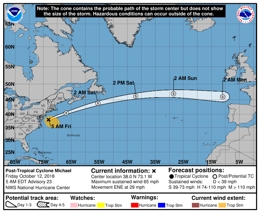
1. Michael continues causing havoc with gust winds and heavy rainfall as it tracks to the northeast. 

Michael still has the potential for toppling trees snapping tree limbs and causing power outages along it's path.  Heavy rains to an area affected by Florence is vulnerable and at risk for more flooding.

Michael is forecast to possibly strengthen some over the Atlantic as it speeds away.

2. Leslie still hanging in but is expected to be downgraded by the end of the forecast to a depression.

3. The center of Nadine is exposed with thunderstorms located to the east of center.  Nadine is encountering wind shear from the west.  Nadine should be a short lived storm no threat to land.

4. NHC is monitoring the Central and South Caribbean for possible development within 5 days.  They are giving this area a 50% chance.

If this low does develop it is forecast to track over Central America as high pressure builds west over the Gulf of Mexico.

Elsewhere the tropics remain quiet for now...RTW

A note to my viewers since I have had many issues with getting website up and running I will be closing it down at end of this season.  A lack of time, and to much to do for one person and the unreliable internet connection here at work, has made it impossible to keep the website updated on time and current.  I will do my best to keep you updated here on the blog.  I will keep alerting you all of potential tropical development as I see it during my daily satellite and model review.  I won't to thank those who help me keep up the site for so many years.
Ralph