Tropical Weather Outlook by NHC
761
AXNT20 KNHC 291750
TWDAT
Tropical Weather Discussion
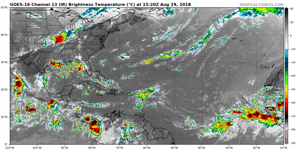
NWS National Hurricane Center Miami FL
150 PM EDT Wed Aug 29 2018
Tropical Weather Discussion for North America, Central America
Gulf of Mexico, Caribbean Sea, northern sections of South
America, and Atlantic Ocean to the African coast from the
Equator to 32N. The following information is based on satellite
imagery, weather observations, radar and meteorological analysis.
Based on 1200 UTC surface analysis and satellite imagery through
1730 UTC.
...TROPICAL WAVES...
An Atlantic Ocean tropical wave is along 31W/32W from 15N
southward. A 1013 mb low pressure center is along the wave near
09N. scattered moderate to widely scattered strong rainshowers
are from 08N to 13N between Africa and 29W. Isolated moderate to
locally strong rainshowers are elsewhere from 07N to 17N between
Africa and 31W.
An Atlantic Ocean-to-Caribbean Sea tropical wave is along 21N58W
16N60W 13N62W 08N62W, ending in Venezuela. Widely scattered
moderate to isolated strong rainshowers from 13N to 20N between
58W and Puerto Rico. Isolated moderate to locally strong
rainshowers are elsewhere from the SE corner of the Caribbean Sea
to 23N in the Atlantic Ocean between 54W and 70W.
A Caribbean Sea tropical wave is along 86W/87W from 22N in the
Yucatan Channel, beyond Central America, into the eastern Pacific
Ocean. Isolated moderate rainshowers are from 18N northward from
the Windward Passage westward.
...MONSOON TROUGH/ITCZ...
The monsoon trough passes through the coastal sections of Senegal
near 16N17W, to 11N25W, to the 1013 mb low pressure center that is
along the 31W/32W tropical wave, 08N38W. The ITCZ continues from
08N38W to 08N49W. widely scattered moderate to isolated strong
rainshowers are from 03N to 10N between 28W and 40W. isolated
moderate rainshowers are elsewhere from 10N southward, mainly
between 40W and 60W.
...DISCUSSION...
GULF OF MEXICO...
A surface trough extends from central Louisiana, to the upper
Texas Gulf coast, to inland south central Texas. Scattered
moderate to isolated/widely scattered strong rainshowers are to
the north of the line from 25N90W to 28N96W from 90W westward.
The upper level inverted trough/cyclonic circulation center from
24 hours ago has moved into Mexico, and now it is along 100W.
Isolated moderate rainshowers are to the west of the line that
runs from 26N95W to 19N92W.
Weak upper level cyclonic wind flow is in the eastern one-third of
the Gulf of Mexico. Widely scattered moderate to isolated strong
rainshowers are from 25N northward from 90W eastward. Isolated
moderate rainshowers are elsewhere from 22N northward in the Gulf
of Mexico.
A weak ridge will dominate the Gulf waters into the weekend and
support gentle to moderate winds. A surface trough will develop
each evening over the Yucatan Peninsula before moving W and
offshore into the SW Gulf overnight. A surge of moderate to fresh
NE to E winds will accompany this trough.
CARIBBEAN SEA...
An upper level east-to-west oriented trough is along 15N/16N from
70W westward to Central America. Upper level cyclonic wind flow
covers the Caribbean Sea from 14N northward from 70W westward.
Isolated moderate rainshowers are in the area of upper level
cyclonic wind flow.
Broad upper level cyclonic wind flow, from a trough, spans the
Caribbean Sea between 60W and 70W. The trough extends from the
Atlantic Ocean, across Puerto Rico to Venezuela. isolated moderate
rainshowers cover the rest of that part of the Caribbean Sea that
is between 60W and 70W. A tropical wave is in the easternmost part
of the Caribbean Sea, with its associated precipitation.
The eastern part of the eastern Pacific monsoon trough is along
09N from 74W in Colombia beyond southern Costa Rica. An upper
level trough extends from southern Nicaragua to Panama. scattered
moderate to strong rainshowers are from 11N southward from 80W and
83W.
Fresh to strong winds will prevail in the south central Caribbean
Sea today, before diminishing from tonight through Saturday.
Gentle to moderate winds will prevail elsewhere.
ATLANTIC OCEAN...
Upper level cyclonic wind flow, with an inverted trough, covers
the Atlantic Ocean from 20N northward from 70W westward. isolated
moderate rainshowers are in the area of cyclonic wind flow.
An upper level trough extends from a 32N40W cyclonic circulation
center, to a second cyclonic circulation center that is near
28N46W, to a third 24N63W cyclonic circulation center, toward the
Windward Passage. Isolated moderate rainshowers are to the NW of
the line that passes through 32N38W to 25N47W to 23N60W to the
Mona Passage.
Surface high pressure will remain centered SW of Bermuda through
the forecast period. Moderate to fresh winds will be S of 24N,
and gentle to moderate winds will be N of 24N. Winds will pulse
to fresh to strong just N of Hispaniola, including the approach
to the Windward Passage, during the evening and overnight hours
through Sunday. A tropical wave moving into the NE Caribbean Sea
and the adjacent Atlantic Ocean today, will produce active
weather as it moves westward across the Lesser Antilles and
Bahamas through Monday.
For additional information please visit
http://www.hurricanes.gov/marine
$$
MT
https://www.nhc.noaa.gov/
----------------------------------------------------------------
Storm Investigation
011
ABNT20 KNHC 291743
TWOAT

Tropical Weather Outlook
NWS National Hurricane Center Miami FL
200 PM EDT Wed Aug 29 2018

For the North Atlantic...Caribbean Sea and the Gulf of Mexico:

A vigorous low pressure area associated with a tropical wave is
forecast to form between the coast of Africa and the Cabo Verde
Islands on Thursday. Conditions appears to be favorable for
development, and a tropical depression could form over the weekend
while the system moves west-northwestward near the Cabo Verde
Islands and the adjacent Atlantic.  This system is expected to bring
rains and gusty winds to those islands in two or three days, and
interests in that region should monitor the progress of this
disturbance.
* Formation chance through 48 hours...low...30 percent.
* Formation chance through 5 days...medium...60 percent.

$$
Forecaster Avila
-----------------------------------------------------------------
African wave has a higher chance for tropical formation but should
stay out over the North Atlantic waters. The system that is forecast
to develop over the Bahamas not very many models other the than the
ECMWF is suggesting development and a track across Florida. I will
continue to monitor but development is still questionable.
Are you Hurricane Ready? RTW


