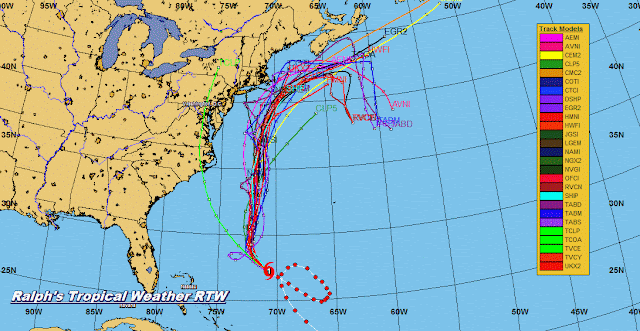
...JOSE A LITTLE STRONGER... ...TROPICAL STORM WATCHES POSSIBLE IN THE UNITED STATES ON SATURDAY...
000
WTNT32 KNHC 160250
TCPAT2

BULLETIN
Hurricane Jose Advisory Number  43
NWS National Hurricane Center Miami FL       AL122017
1100 PM EDT Fri Sep 15 2017

...JOSE A LITTLE STRONGER...
...TROPICAL STORM WATCHES POSSIBLE IN THE UNITED STATES ON
SATURDAY...


SUMMARY OF 1100 PM EDT...0300 UTC...INFORMATION
-----------------------------------------------
LOCATION...27.4N 71.0W
ABOUT 600 MI...965 KM SSE OF CAPE HATTERAS NORTH CAROLINA
ABOUT 500 MI...810 KM SW OF BERMUDA
MAXIMUM SUSTAINED WINDS...80 MPH...130 KM/H
PRESENT MOVEMENT...NW OR 305 DEGREES AT 9 MPH...15 KM/H
MINIMUM CENTRAL PRESSURE...983 MB...29.03 INCHES


WATCHES AND WARNINGS
--------------------
There are no coastal watches or warnings in effect.

Interests from North Carolina northward to New England on the east
coast of the United States should monitor the progress of this
system.  A Tropical Storm Watch may be needed for a portion of the
coast of North Carolina on Saturday.


DISCUSSION AND 48-HOUR OUTLOOK
------------------------------
At 1100 PM EDT (0300 UTC), the center of Hurricane Jose was located
near latitude 27.4 North, longitude 71.0 West. Jose is moving toward
the northwest near 9 mph (15 km/h).  A gradual turn toward the north
is expected over the next couple of days.

The estimated maximum sustained winds have increased to near 80 mph
(130 km/h) with higher gusts.  Additional strengthening is expected
this weekend.

Hurricane-force winds extend outward up to 35 miles (55 km) from the
center and tropical-storm-force winds extend outward up to 150 miles
(240 km).

The estimated minimum central pressure is 983 mb (29.03 inches).


HAZARDS AFFECTING LAND
----------------------
SURF:  Swells generated by Jose are affecting Bermuda, the Bahamas,
the northern coasts of Hispaniola and Puerto Rico, and the southeast
coast of the United States, and will spread northward along the
Mid-Atlantic coast of the U.S. during the next few days.  These
swells are likely to cause life-threatening surf and rip current
conditions.  For more information, please consult products from your
local weather office.


NEXT ADVISORY
-------------
Next complete advisory at 500 AM EDT.

$$
Forecaster Zelinsky


...DEPRESSION MOVING WESTWARD WITH NO CHANGE IN STRENGTH...
ZCZC MIATCPAT4 ALL
TTAA00 KNHC DDHHMM

BULLETIN
Tropical Depression Fourteen Advisory Number   5
NWS National Hurricane Center Miami FL       AL142017
1100 PM AST Fri Sep 15 2017

...DEPRESSION MOVING WESTWARD WITH NO CHANGE IN STRENGTH...


SUMMARY OF 1100 PM AST...0300 UTC...INFORMATION
-----------------------------------------------
LOCATION...12.8N 30.7W
ABOUT 500 MI...805 KM WSW OF THE CABO VERDE ISLANDS
MAXIMUM SUSTAINED WINDS...35 MPH...55 KM/H
PRESENT MOVEMENT...W OR 280 DEGREES AT 10 MPH...17 KM/H
MINIMUM CENTRAL PRESSURE...1009 MB...29.80 INCHES


WATCHES AND WARNINGS
--------------------
There are no coastal watches or warnings in effect.


DISCUSSION AND 48-HOUR OUTLOOK
------------------------------
At 1100 PM AST (0300 UTC), the center of Tropical Depression
Fourteen was located near latitude 12.8 North, longitude 30.7 West.
The depression is moving toward the west near 10 mph (17 km/h), and
a westward motion with some decrease in forward speed is expected
over the next couple of days.

Maximum sustained winds are near 35 mph (55 km/h) with higher gusts.
Some slightly strengthening is possible, and the depression could
become a tropical storm over the weekend.

The estimated minimum central pressure is 1009 mb (29.80 inches).


HAZARDS AFFECTING LAND
----------------------
None


NEXT ADVISORY
-------------
Next complete advisory at 500 AM AST.

$$
Forecaster Brown


No comments:
Post a Comment
Note: Only a member of this blog may post a comment.