
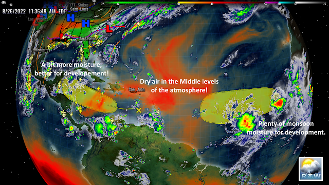
AS FOR THE AFRICAN STORM INVEST SOUTHWEST OF THE CABO VERDE ISLANDS, THIS SYSTEM HAS A BIT MORE THUNDERSTORMS BUT DISORGANIZED AT THIS TIME. THE EURO MODEL STILL HINTS DEVELOPMENT INTO A TROPICAL CYCLONE AS IT TRACKS FURTHER WEST.
NHC IS NOT TALKING MUCH ABOUT A LOW ASSOCIATED WITH MONSOON STORM ACTIVITY, SEVERAL HUNDRED MILES WEST-SOUTHWEST OF THE AFRICAN STORM INVEST. THIS SYSTEM HAS BEEN HOLDING UP WELL, HAS A NICE CIRCULATION, AND IS ACCOMPANIED BY THUNDERSTORM ACTIVITY WITH LIGHTNING. SEEMS BETTER ORGANIZED. I WILL WATCH IT CLOSELY.
A PERSISTENT SURFACE TROUGH OF LOW PRESSURE NORTH-NORTHEAST OF THE BAHAMAS CONTINUES TO LINGER IN THIS AREA. EURO ENSEMBLE MODELS SEEMS TO DEVELOP THIS SYSTEM SOME, AND TRACKS IT NORTHEAST AWAY FROM THE EASTERN SEABOARD. WATCHING THIS ONE CLOSELY AS WELL.
RTW
000
ABNT20 KNHC 261140
TWOAT

Tropical Weather Outlook
NWS National Hurricane Center Miami FL
800 AM EDT Fri Aug 26 2022

For the North Atlantic...Caribbean Sea and the Gulf of Mexico:

Eastern Tropical Atlantic:
A tropical wave located to the west of the Cabo Verde Islands is
producing a large area of disorganized showers and thunderstorms.
Environmental conditions could support some gradual development of
this system through early next week while it moves westward across
the eastern and central tropical Atlantic at 10 to 15 mph.
* Formation chance through 48 hours...low...10 percent.
* Formation chance through 5 days...low...30 percent.

Eastern Caribbean Sea:
A trough of low pressure located over the eastern Caribbean Sea is
producing minimal shower and thunderstorm activity. This system is
expected to move westward at about 15 mph during the next several
days, and environmental conditions could become more conducive for
slow development by early next week when it moves across the central
and western Caribbean Sea.
* Formation chance through 48 hours...low...near 0 percent.
* Formation chance through 5 days...low...20 percent.

$$
Forecaster Reinhart


.gif)


.gif)


No comments:
Post a Comment
Note: Only a member of this blog may post a comment.