Strong showers and storms moving through the Windward Islands ahead of a tropical wave. Gusty winds and heavy rains moving through this area today.
Strong showers and storms accompany a tropical wave passing over Dominican Republic and Haiti. If these storms hold together they could bring showers and storms to Southern Bahamas, portions of eastern Cuba and Florida in the coming days.
RTW
000
AXNT20 KNHC 091035
TWDAT

Tropical Weather Discussion
NWS National Hurricane Center Miami FL
1205 UTC Wed Aug 9 2023

Tropical Weather Discussion for North America, Central America
Gulf of Mexico, Caribbean Sea, northern sections of South
America, and Atlantic Ocean to the African coast from the
Equator to 31N. The following information is based on satellite
imagery, weather observations, radar and meteorological analysis.

Based on 0600 UTC surface analysis and satellite imagery through
1000 UTC.

...TROPICAL WAVES...

An eastern Atlantic tropical wave has its axis along 20W, south
of 17N, moving westward at 5 kt. Scattered moderate convection is
noted from 09N to 14N and east of 23W.

Another eastern Atlantic tropical wave has its axis along 35W,
south of 17N, moving westward at 15-20 kt. Scattered moderate
convection is noted from 05N to 08N between 35W and 37W.

A central Atlantic tropical wave has its axis along 58W, south of
19N, moving westward at 15-20 kt. Scattered moderate to isolated
strong convection is evident from 10N to 15N and between 57W and
61W. These storms are likely producing gusty winds. Seas in the
area range 4-6 ft.

A central Caribbean tropical wave has its axis along 72W, south
of 20N, moving westward at 15-20 kt. Scattered thunderstorms are
noted in the northern portion of the trough axis, N of Hispaniola
from 19N to 22N between 69W and 74W.

A western Caribbean tropical wave has its axis along 86W, south
of 19N, moving westward at 15-20 kt. Most of the convection
associated with this wave is occurring in the eastern Pacific.

...MONSOON TROUGH/ITCZ...

The monsoon trough reaches the Atlantic through the coast of
Guinea-Bissau near 12N16W and continues westward to 10N40W. The
ITCZ extends from 10N40W to 13N57W. Scattered moderate convection
is noted from 06N to 14N and E of 27W and from 05N to 11N between
29W and 34W.

GULF OF MEXICO...

A trough extends in the eastern Bay of Campeche with showers near
it. Otherwise, weak riding extends across the Gulf of Mexico.
The pressure gradient between the aforementioned ridge and lower
pressures over Mexico support moderate to locally fresh E-SE in
the western Gulf and Bay of Campeche. The wave heights in the
region described are 2-4 ft. Moderate or weaker winds and slight
seas prevail in the rest of the basin.

For the forecast, weak high pressure centered over the NE Gulf will
support gentle to moderate winds over most of the basin during
the next several days. Winds across the western Gulf will increase
to moderate to fresh tonight, continuing through most of the
week. A thermal trough will move off the Yucatan Peninsula each
night, producing moderate to fresh winds to the northwest of the
Yucatan Peninsula through the weekend.

CARIBBEAN SEA...

A few showers and isolated thunderstorms persist in the lee of
Cuba and near the Cayman Islands, from 17N to 22N between 78W and
84W. Similar convection is evident in the SW Caribbean Sea,
mainly within 100 nm of northern Panama and Costa Rica. The
remainder of the basin is under fairly tranquil weather
conditions.

A weak pressure gradient between the subtropical ridge in the
central Atlantic and lower pressures in northern South America
support moderate to locally fresh easterly trade winds in the
central Caribbean, along with seas of 4-6 ft. Locally moderate or
weaker winds and slight to moderate seas prevail elsewhere.

For the forecast, gentle to moderate trade winds will prevail
over the Caribbean through tonight, with fresh winds in the south-
central basin. A tropical wave will move into the eastern and
central Caribbean Thu through Sat, bringing fresh to strong winds
and moderate seas. By Sun, fresh winds and moderate seas will
prevail through most of the basin.

ATLANTIC OCEAN...

Scattered moderate to isolated strong convection persist off NE
Florida due to divergence aloft. The rest of the tropical Atlantic
is dominated by an expansive 1020 mb subtropical ridge positioned
near 26N67W and 26N27W. This is allowing for fairly tranquil
weather conditions. The pressure gradient between the ridge and
lower pressures in the Caribbean region sustain moderate to
locally fresh easterly trade winds south of 25N and west of 50W.
The seas in these waters are 4-7 ft. Moderate to locally fresh
southerly winds are noted north of 27N and west of 35W, along with
seas of 4-8 ft. The highest seas are present near 31N44W.
Moderate or weaker winds and slight to moderate seas prevail
elsewhere.

For the forecast W of 55W, the subtropical ridge axis will
continue to be situated along 28N through much of the week.
Moderate to locally fresh winds can be expected through tonight S
of 25N and E of 78W. Later in the week, the northern portion of a
tropical wave is expected to move across the southeastern waters.
This will increase winds fresh to strong with moderate seas across
the region Thu through Sat, including the Bahamas. Moderate to
locally fresh winds will resume on Sun.

$$
AReinhart
000
ABNT20 KNHC 091134
TWOAT

Tropical Weather Outlook
NWS National Hurricane Center Miami FL
800 AM EDT Wed Aug 9 2023

For the North Atlantic...Caribbean Sea and the Gulf of Mexico:

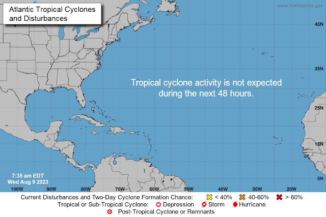
Tropical cyclone formation is not expected during the next 7 days.

$$
Forecaster Berg
South Dade GMRS Club (General Mobile Radio Service)
Partners with the American Red Cross


No comments:
Post a Comment
Note: Only a member of this blog may post a comment.