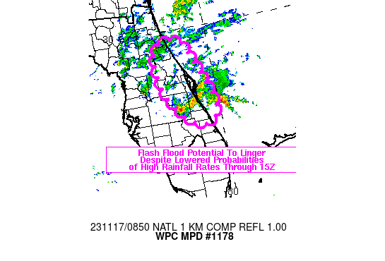
Mesoscale Precipitation Discussion 1178
NWS Weather Prediction Center College Park MD
353 AM EST Fri Nov 17 2023

Areas affected...east-central to northeastern FL Peninsula

Concerning...Heavy rainfall...Flash flooding possible

Valid 170850Z - 171445Z

SUMMARY...A flash flood threat will linger across portions of the
east-central to northeastern FL Peninsula into mid-morning,
although the coverage/probabilities of high rainfall rates appear
to be lower than earlier in the night. Highly localized rainfall
rates over 3 in/hr will remain possible through 14Z.

DISCUSSION...3.9 micron satellite imagery and 08Z surface
observations showed a surface low located ~40 miles NNW of western
Grand Bahama Island, moving toward the northwest into the greatest
pressure tendency falls. Meanwhile, a 1006 mb mesoscale low had
formed over Indian River County, west of Vero Beach, along a
south-north oriented coastal boundary that pushed inland, located
just west of ISM and northward across St. Johns County at 08Z.
Infrared satellite imagery showed that the elevated reflection of
this inland low near the coast has drifted 10-20 miles offshore of
Indian River County along with the heaviest rain associated with
the low. Farther inland, slow moving cells with relatively warm
cloud tops were located over western Osceola County with earlier
MRMS-derived rainfall rates over 4 in/hr locally, but with recent
decreased rainfall intensities.

While trends in radar imagery over the past 1-2 hours have shown
oscillations in rainfall intensity with rainfall in and around
east-central FL and cell organization has waned somewhat since
06Z, a localized threat for heavy rain will continue through
mid-morning. A localized flash flood threat near the mesolow just
offshore of Indian River County will exist should the low
translate back toward the coast, although the future persistence
of this feature is uncertain.

Otherwise, the synoptic scale low NNW of western Grand Bahama
Island is forecast to follow a northwestward motion toward the
east-central FL coast through 14Z, with the strongest (20-30 kt
925-850 mb winds) focusing from near Cape Canaveral to St. Johns
County. low level convergence at the nose of these easterly winds
will continue a threat for slow moving cells capable of rainfall
rates locally over 3 in/hr near and east of the north-south
convergence axis. However, effective bulk shear values are
forecast to decrease through the remainder of the morning which
should limit cell organization.

Therefore, while the coverage and probabilities of high (2 to 3+
in/hr) rainfall rates appears to decrease over the next 3-6 hours,
a localized flash flood threat will remain across portions of the
east-central to northeastern FL Peninsula into the mid-morning
hours.

Otto


No comments:
Post a Comment
Note: Only a member of this blog may post a comment.