Thursday, June 4, 2020

TROPICAL DEPRESSION CRISTOBAL 1000 PM EDT

000
WTNT33 KNHC 050235
TCPAT3

BULLETIN
Tropical Depression Cristobal Advisory Number  14
NWS National Hurricane Center Miami FL       AL032020
1000 PM CDT Thu Jun 04 2020

...LIFE-THREATENING FLOODING CONTINUES ACROSS PORTIONS OF MEXICO 
AND CENTRAL AMERICA...
...CRISTOBAL EXPECTED TO MOVE BACK OVER WATER BY FRIDAY NIGHT...


SUMMARY OF 1000 PM CDT...0300 UTC...INFORMATION
-----------------------------------------------
LOCATION...17.8N 90.4W
ABOUT 145 MI...235 KM S OF CAMPECHE MEXICO
MAXIMUM SUSTAINED WINDS...35 MPH...55 KM/H
PRESENT MOVEMENT...E OR 90 DEGREES AT 3 MPH...6 KM/H
MINIMUM CENTRAL PRESSURE...1000 MB...29.53 INCHES


WATCHES AND WARNINGS
--------------------
CHANGES WITH THIS ADVISORY:

None.

SUMMARY OF WATCHES AND WARNINGS IN EFFECT:

There are no coastal watches or warnings in effect.

Interests along the northern coast of the Gulf of Mexico should
monitor the progress of Cristobal.  A tropical storm watch and a
storm surge watch will likely be required for a portion of the area
on Friday.


DISCUSSION AND OUTLOOK
----------------------
At 1000 PM CDT (0300 UTC), the center of Tropical Depression
Cristobal was located inland near latitude 17.8 North, longitude 
90.4 West. The depression is moving toward the east near 3 mph (6 
km/h).  A turn toward the northeast is expected overnight, and a 
subsequent northward motion should occur through Sunday.  On the 
forecast track, the center will move over extreme northwestern 
Guatemala and eastern Mexico on Friday.  The center is forecast to 
move back over the southern Gulf of Mexico by Friday night, over the 
central Gulf of Mexico on Saturday, and approach the northern Gulf 
of Mexico coast Sunday and Sunday night.

Maximum sustained winds are near 35 mph (55 km/h) with higher gusts.
Little change in strength is expected over the next day or so, but 
slow strengthening is forecast to occur this weekend  when 
Cristobal moves back over water.

The estimated minimum central pressure is 1000 mb (29.53 inches).


HAZARDS AFFECTING LAND
----------------------
Key messages for Cristobal can be found in the Tropical Cyclone
Discussion under AWIPS header MIATCDAT3, WMO header WTNT43 KNHC, and
on the web at www.hurricanes.gov/text/MIATCDAT3.shtml

RAINFALL: Cristobal is expected to produce the following rain
accumulations through Saturday:

Mexican states of Campeche, Quintana Roo, and Yucatan...Additional 5
to 10 inches, isolated storm totals of 25 inches.

Belize and the Mexican states of Tabasco, Veracruz and
Oaxaca...Additional 2 to 4 inches.

Southern Guatemala and parts of Chiapas...Additional 10 to 15
inches, isolated storm total amounts of 35 inches dating back to
Saturday, May 30th.

El Salvador...Additional 5 to 10 inches, isolated storm total
amounts of 35 inches dating back to Saturday, May 30th.

Southern parts of Honduras...Additional 3 to 6 inches, isolated 10
inches.

Rainfall in all of these areas may produce life-threatening flash
floods and mudslides.

Heavy rainfall will spread into portions of the Gulf Coast, from
east Texas to Florida, this weekend into early next week, with areas
of flash flooding possible.


NEXT ADVISORY
-------------
Next complete advisory at 400 AM CDT.

$$
Forecaster Cangialosi


TROPICAL DEPRESSION CRISTOBAL 0400 PM EDT

TROPICAL DEPRESSION CRISTOBAL 0400 PM EDT UPDATE

000
WTNT33 KNHC 042040
TCPAT3

BULLETIN
Tropical Depression Cristobal Advisory Number  13
NWS National Hurricane Center Miami FL       AL032020
400 PM CDT Thu Jun 04 2020

...CRISTOBAL CONTINUES TO PRODUCE HEAVY RAINS AND LIFE-THREATENING
FLOODING...
...EXPECTED TO MOVE BACK INTO THE GULF OF MEXICO TOMORROW NIGHT...


SUMMARY OF 400 PM CDT...2100 UTC...INFORMATION
----------------------------------------------
LOCATION...17.5N 90.8W
ABOUT 165 MI...270 KM S OF CAMPECHE MEXICO
MAXIMUM SUSTAINED WINDS...35 MPH...55 KM/H
PRESENT MOVEMENT...ESE OR 110 DEGREES AT 3 MPH...6 KM/H
MINIMUM CENTRAL PRESSURE...999 MB...29.50 INCHES


WATCHES AND WARNINGS
--------------------
CHANGES WITH THIS ADVISORY:

None.

SUMMARY OF WATCHES AND WARNINGS IN EFFECT:

There are no coastal watches or warnings in effect.

Interests along the northern coast of the Gulf of Mexico should
monitor the progress of Cristobal.  A tropical storm watch and a
storm surge watch may be required for a portion of the area tonight
or Friday.


DISCUSSION AND OUTLOOK
----------------------
At 400 PM CDT (2100 UTC), the center of Tropical Depression
Cristobal was located near latitude 17.5 North, longitude 90.8 West.
The depression is moving toward the east-southeast near 3 mph (6
km/h).  A turn toward the east and northeast is expected tonight, 
and a subsequent generally northward motion should occur through 
Sunday.  On the forecast track, the center will move over extreme 
northwestern Guatemala and eastern Mexico tonight and Friday.  The 
center is forecast to move back over the southern Gulf of Mexico 
late Friday, over the central Gulf of Mexico on Saturday, and 
approach the northern Gulf of Mexico coast Sunday and Sunday night.

Maximum sustained winds are near 35 mph (55 km/h) with higher gusts.
Some additional weakening is possible overnight.  Re-intensification 
is expected to begin late Friday.

The estimated minimum central pressure is 999 mb (29.50 inches).


HAZARDS AFFECTING LAND
----------------------
Key messages for Cristobal can be found in the Tropical Cyclone
Discussion under AWIPS header MIATCDAT3, WMO header WTNT43 KNHC, and
on the web at www.hurricanes.gov/text/MIATCDAT3.shtml

RAINFALL: Cristobal is expected to produce the following rain
accumulations through Saturday:

Mexican states of Campeche, Quintana Roo, and Yucatan...Additional 5
to 10 inches, isolated storm totals of 25 inches.

Belize and the Mexican states of Tabasco, Veracruz and
Oaxaca...Additional 2 to 4 inches.

Southern Guatemala and parts of Chiapas...Additional 10 to 15
inches, isolated storm total amounts of 35 inches dating back to
Saturday, May 30th.

El Salvador...Additional 5 to 10 inches, isolated storm total
amounts of 35 inches dating back to Saturday, May 30th.

Southern parts of Honduras...Additional 3 to 6 inches, isolated 10
inches.

Rainfall in all of these areas may produce life-threatening flash
floods and mudslides.

Heavy rainfall will spread into portions of the Gulf Coast, from
east Texas to Florida, this weekend into early next week, with areas
of flash flooding possible.

NEXT ADVISORY
-------------
Next complete advisory at 1000 PM CDT.

$$
Forecaster Pasch


TROPICAL DEPRESSION CRISTOBAL

CRISTOBAL DOWNGRADED TO A DEPRESSION
000
WTNT33 KNHC 041444
TCPAT3

BULLETIN
Tropical Depression Cristobal Advisory Number  12
NWS National Hurricane Center Miami FL       AL032020
1000 AM CDT Thu Jun 04 2020

...CRISTOBAL WEAKENS TO A DEPRESSION BUT CONTINUES TO PRODUCE HEAVY
RAINS AND LIFE-THREATENING FLOODING...


SUMMARY OF 1000 AM CDT...1500 UTC...INFORMATION
-----------------------------------------------
LOCATION...17.6N 91.0W
ABOUT 160 MI...260 KM SSW OF CAMPECHE MEXICO
MAXIMUM SUSTAINED WINDS...35 MPH...55 KM/H
PRESENT MOVEMENT...ESE OR 120 DEGREES AT 3 MPH...6 KM/H
MINIMUM CENTRAL PRESSURE...998 MB...29.47 INCHES


WATCHES AND WARNINGS
--------------------
CHANGES WITH THIS ADVISORY:

The government of Mexico has discontinued the Tropical Storm
Warning from Campeche to Coatzacoalcos.

SUMMARY OF WATCHES AND WARNINGS IN EFFECT:

There are no coastal watches or warnings in effect.

Tropical storm watches or warnings may be required for portions of
the Yucatan Peninsula of Mexico later today.  Interests there and
along the northern coast of the Gulf of Mexico should monitor the
progress of Cristobal.


DISCUSSION AND OUTLOOK
----------------------
At 1000 AM CDT (1500 UTC), the center of Tropical Depression
Cristobal was located near latitude 17.6 North, longitude 91.0 West.
The depression is moving toward the east-southeast near 3 mph (6
km/h), and this motion should continue through midday.  A turn 
toward the east and northeast is expected later today, and a 
subsequent northward motion should occur through Sunday.  On the 
forecast track, the center will move over the land mass of extreme 
northwestern Guatemala and eastern Mexico today and tonight.  The 
center is forecast to move back over the southern Gulf of Mexico 
Friday or Friday night, over the central Gulf of Mexico on 
Saturday, and approach the northern Gulf of Mexico coast Sunday and 
Sunday night.

Maximum sustained winds have decreased to near 35 mph (55 km/h)
with higher gusts.  Little change in strength is expected through
tonight.  Re-intensification is expected to begin on Friday.

The estimated minimum central pressure is 998 mb (29.47 inches).


HAZARDS AFFECTING LAND
----------------------
Key messages for Cristobal can be found in the Tropical Cyclone
Discussion under AWIPS header MIATCDAT3, WMO header WTNT43 KNHC, and
on the web at www.hurricanes.gov/text/MIATCDAT3.shtml

RAINFALL: Cristobal is expected to produce the following rain
accumulations through Saturday:

Mexican states of Campeche, Quintana Roo, Tabasco, and Yucatan...
Additional 6 to 12 inches, isolated storm totals of 25 inches.

Mexican states of Veracruz and Oaxaca...Additional 5 to 10 inches.

Southern Guatemala and parts of Chiapas...Additional 15 to 20
inches, isolated storm total amounts of 35 inches dating back to
Saturday, May 30th.

El Salvador...Additional 10 to 15 inches, isolated storm total
amounts of 35 inches dating back to Saturday, May 30th.

Belize and Honduras...Additional 3 to 6 inches, isolated 10 inches.

Rainfall in all of these areas may produce life-threatening flash
floods and mudslides.


NEXT ADVISORY
-------------
Next complete advisory at 400 PM CDT.

$$
Forecaster Pasch 


Wednesday, June 3, 2020

CRISTOBAL UPDATE

CRISTOBAL LATEST UPDATE
506 
WTNT33 KNHC 040239
TCPAT3

BULLETIN
Tropical Storm Cristobal Advisory Number  10
NWS National Hurricane Center Miami FL       AL032020
1000 PM CDT Wed Jun 03 2020

...CRISTOBAL MOVING VERY LITTLE WHILE IT CONTINUES TO CAUSE HEAVY
RAINFALL AND LIFE-THREATENING FLOODING...


SUMMARY OF 1000 PM CDT...0300 UTC...INFORMATION
-----------------------------------------------
LOCATION...18.3N 91.8W
ABOUT 20 MI...35 KM S OF CIUDAD DEL CARMEN MEXICO
MAXIMUM SUSTAINED WINDS...45 MPH...75 KM/H
PRESENT MOVEMENT...STATIONARY
MINIMUM CENTRAL PRESSURE...995 MB...29.39 INCHES


WATCHES AND WARNINGS
--------------------
CHANGES WITH THIS ADVISORY:

None.

SUMMARY OF WATCHES AND WARNINGS IN EFFECT:

A Tropical Storm Warning is in effect for...
* Campeche to Coatzacoalcos Mexico

For storm information specific to your area, please monitor
products issued by your national meteorological service.


DISCUSSION AND OUTLOOK
----------------------
At 1000 PM CDT (0300 UTC), the center of Tropical Storm Cristobal
was located near latitude 18.3 North, longitude 91.8 West. Cristobal
has been nearly stationary this evening but a slow southeast or 
east motion should resume overnight.  A turn toward the 
north-northeast and north is expected on Thursday, and a general 
northward motion should continue through Saturday.  On the forecast 
track, the center will move over the land mass of eastern Mexico 
through Thursday.  The center is forecast to move back over the 
southern Gulf of Mexico on Friday, and over the central Gulf of 
Mexico on Saturday.

Maximum sustained winds are near 45 mph (75 km/h) with higher gusts.
Slow weakening will occur while the cyclone moves over land, and 
Cristobal will likely become a tropical depression by Thursday 
evening.  Some re-strengthening is expected to begin on Friday.

Tropical-storm-force winds extend outward up to 60 miles (95 km)
from the center, primarily over water.

The estimated minimum central pressure is 995 mb (29.39 inches).


HAZARDS AFFECTING LAND
----------------------
Key messages for Cristobal can be found in the Tropical Cyclone
Discussion under AWIPS header MIATCDAT3, WMO header WTNT43 KNHC, and
on the web at www.hurricanes.gov/text/MIATCDAT3.shtml

RAINFALL: Cristobal is expected to produce the following rain
accumulations through Saturday:

Mexican states of Campeche, Quintana Roo, Tabasco, and Yucatan...6
to 12 inches, isolated storm totals of 25 inches.

Mexican states of Veracruz and Oaxaca...5 to 10 inches.

Southern Guatemala and parts of Chiapas...Additional 15 to 20
inches, isolated storm total amounts of 35 inches dating back to
Saturday, May 30th.

El Salvador...Additional 10 to 15 inches, isolated storm total
amounts of 35 inches dating back to Saturday, May 30th.

Belize and Honduras...3 to 6 inches, isolated 10 inches.

Rainfall in all of these areas may produce life-threatening flash
floods and mudslides.

WIND:  Tropical storm conditions are affecting the coast within
portions of the warning area.


NEXT ADVISORY
-------------
Next intermediate advisory at 100 AM CDT.
Next complete advisory at 400 AM CDT.

$$
Forecaster Brown


CRISTOBAL UPDATE 0400 PM EDT

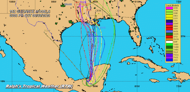
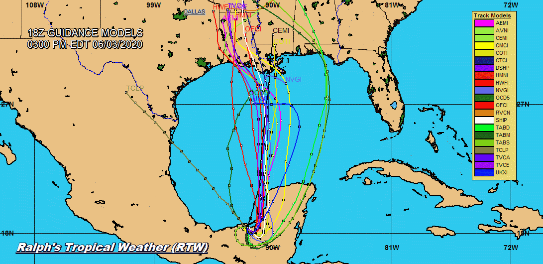
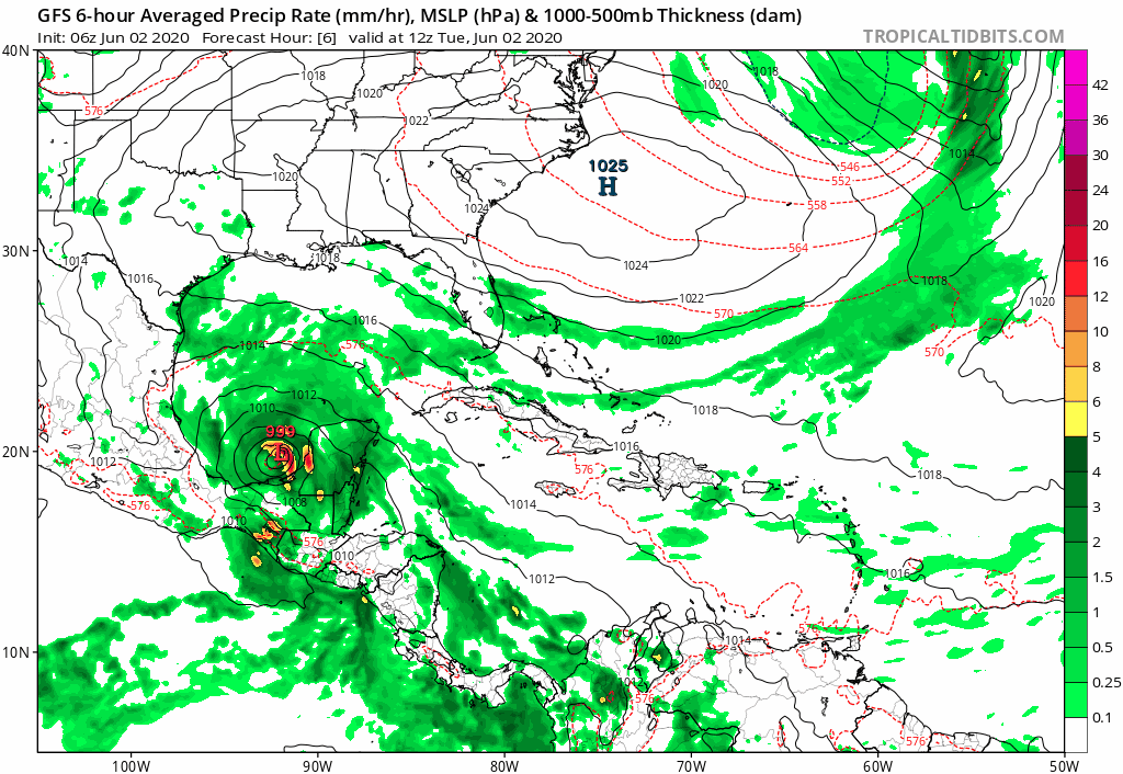
CRISTOBAL NOT LOOKING AS WELL ORGANIZED NOW THAT THE CENTER IS OVER LAND.  SHOULD REGAIN STRENGTH AS CRISTOBAL MOVES AWAY FROM THE YUCATAN IN A COUPLE OF DAYS.  HEAVY RAINS LIFE-THREATENING FLASH FLOODS AND MUD SLIDES MAIN CONCERN WITH THIS STORM SYSTEM.

RTW

NATIONAL HURRICANE CENTER PUBLIC ADVISORY
000
WTNT33 KNHC 032038
TCPAT3

BULLETIN
Tropical Storm Cristobal Advisory Number   9
NWS National Hurricane Center Miami FL       AL032020
400 PM CDT Wed Jun 03 2020

...CRISTOBAL WEAKENING VERY SLOWLY WHILE MOVING OVER LAND...
...THREAT OF HEAVY RAIN AND FLOODING CONTINUES...


SUMMARY OF 400 PM CDT...2100 UTC...INFORMATION
----------------------------------------------
LOCATION...18.3N 91.8W
ABOUT 20 MI...35 KM S OF CIUDAD DEL CARMEN MEXICO
MAXIMUM SUSTAINED WINDS...50 MPH...85 KM/H
PRESENT MOVEMENT...SE OR 135 DEGREES AT 3 MPH...6 KM/H
MINIMUM CENTRAL PRESSURE...995 MB...29.39 INCHES


WATCHES AND WARNINGS
--------------------
CHANGES WITH THIS ADVISORY:

None.

SUMMARY OF WATCHES AND WARNINGS IN EFFECT:

A Tropical Storm Warning is in effect for...
* Campeche to Coatzacoalcos Mexico

For storm information specific to your area, please monitor
products issued by your national meteorological service.


DISCUSSION AND OUTLOOK
----------------------
At 400 PM CDT (2100 UTC), the center of Tropical Storm Cristobal was
located near latitude 18.3 North, longitude 91.8 West.  Cristobal is
moving toward the southeast near 3 mph (6 km/h), and a turn toward 
the east is expected by tonight.  A turn toward the north-northeast 
and north is expected on Thursday and Friday.  On the forecast 
track, the center will move over the land mass of eastern Mexico 
through Thursday.  The center is forecast to move back over the 
southern Gulf of Mexico by Friday, and over the central Gulf of 
Mexico on Saturday. 

Maximum sustained winds are near 50 mph (85 km/h) with higher gusts.
Slow weakening will occur while the cyclone moves over land, and 
Cristobal will likely become a tropical depression by Thursday 
evening.  Some re-strengthening is expected to begin on Friday.

Tropical-storm-force winds extend outward up to 60 miles (95 km)
from the center.

The estimated minimum central pressure is 995 mb (29.39 inches).


HAZARDS AFFECTING LAND
----------------------
Key messages for Cristobal can be found in the Tropical Cyclone
Discussion under AWIPS header MIATCDAT3, WMO header WTNT43 KNHC, and
on the web at www.hurricanes.gov/text/MIATCDAT3.shtml

RAINFALL: Cristobal is expected to produce the following 
rain accumulations through Friday night:

Mexican states of Campeche, northern Chiapas, Quintana Roo, Tabasco,
and Yucatan...10 to 20 inches, isolated 25 inches.

Mexican state of southern Chiapas...15 to 20 inches, isolated 25
inches.

Mexican states of Veracruz and Oaxaca...5 to 10 inches.

Southern Guatemala...Additional 15 to 20 inches, isolated storm
total amounts of 35 inches dating back to Saturday, May 30th.

El Salvador...Additional 10 to 15 inches, isolated storm total
amounts of 35 inches dating back to Saturday, May 30th.

Belize and Honduras...3 to 6 inches, isolated 10 inches.

Rainfall in all of these areas may produce life-threatening flash
floods and mudslides.

WIND:  Tropical storm conditions are affecting the coast within
portions of the warning area.


NEXT ADVISORY
-------------
Next intermediate advisory at 700 PM CDT.
Next complete advisory at 1000 PM CDT.

$$
Forecaster Pasch


TROPICAL STORM CRISTOBAL 1000 AM EDT UPDATE

CRISTOBAL INLAND OVER THE STATE OF CAMPECHE, HEAVY RAINS FLASH FLOOD MUD SLIDES THE MAIN THREAT.
RTW
10AM EDT UPDATE

NATIONAL HURRICANE CENTER
000
WTNT33 KNHC 031454
TCPAT3

BULLETIN
Tropical Storm Cristobal Advisory Number   8
NWS National Hurricane Center Miami FL       AL032020
1000 AM CDT Wed Jun 03 2020

...CRISTOBAL MOVING INLAND OVER EASTERN MEXICO...
...THREAT OF HEAVY RAINS AND LIFE-THREATENING FLOODING WILL
CONTINUE...


SUMMARY OF 1000 AM CDT...1500 UTC...INFORMATION
-----------------------------------------------
LOCATION...18.6N 92.0W
ABOUT 15 MI...20 KM W OF CIUDAD DEL CARMEN MEXICO
MAXIMUM SUSTAINED WINDS...60 MPH...95 KM/H
PRESENT MOVEMENT...SSE OR 150 DEGREES AT 3 MPH...6 KM/H
MINIMUM CENTRAL PRESSURE...995 MB...29.39 INCHES


WATCHES AND WARNINGS
--------------------
CHANGES WITH THIS ADVISORY:

The government of Mexico has discontinued the Tropical Storm
Warning west of Coatzacoalcos, Mexico.

SUMMARY OF WATCHES AND WARNINGS IN EFFECT:

A Tropical Storm Warning is in effect for...
* Campeche to Coatzacoalcos Mexico

For storm information specific to your area, please monitor
products issued by your national meteorological service.


DISCUSSION AND OUTLOOK
----------------------
At 1000 AM CDT (1500 UTC), the center of Tropical Storm Cristobal
was located near latitude 18.6 North, longitude 92.0 West.  
Cristobal is moving toward the south-southeast near 3 mph (6 km/h), 
and a turn toward the east is expected later today.  A turn toward 
the north-northeast and north is expected on Thursday and Friday.  
On the forecast track, the center will move over the land mass of 
eastern Mexico through Thursday.  The center is forecast to move 
back over the Gulf of Mexico by Friday.

Maximum sustained winds are near 60 mph (95 km/h) with higher gusts.
Slow weakening is forecast during the next 48 hours, and Cristobal 
will likely become a tropical depression by Thursday evening.  Some 
re-strengthening is expected to begin on Friday.

Tropical-storm-force winds extend outward up to 60 miles (95 km)
from the center.

The estimated minimum central pressure is 995 mb (29.39 inches).


HAZARDS AFFECTING LAND
----------------------
Key messages for Cristobal can be found in the Tropical Cyclone
Discussion under AWIPS header MIATCDAT3, WMO header WTNT43 KNHC, and
on the web at www.hurricanes.gov/text/MIATCDAT3.shtml

RAINFALL: Cristobal is expected to produce the following rain
accumulations through Friday night:

Mexican states of Campeche, northern Chiapas, Quintana Roo, Tabasco,
and Yucatan...10 to 20 inches, isolated 25 inches.

Mexican state of southern Chiapas...15 to 20 inches, isolated 25
inches.

Mexican states of Veracruz and Oaxaca...5 to 10 inches.

Southern Guatemala...Additional 15 to 20 inches, isolated storm
total amounts of 35 inches dating back to Saturday, May 30th.

El Salvador...Additional 10 to 15 inches, isolated storm total
amounts of 35 inches dating back to Saturday, May 30th.

Belize and Honduras...3 to 6 inches, isolated 10 inches.

Rainfall in all of these areas may produce life-threatening flash
floods and mudslides.

WIND:  Tropical storm conditions are affecting the coast within
portions of the warning area.


NEXT ADVISORY
-------------
Next intermediate advisory at 100 PM CDT.
Next complete advisory at 400 PM CDT.

$$
Forecaster Pasch/Berg