Saturday, June 6, 2020

TROPICAL STORM CRISTOBAL UPDATE 0400 PM EDT

CRISTOBAL DISORGANIZED CENTER REMAINS VOID OF THUNDERSTORMS.  UPPER LEVEL SHEAR AND DRY AIR INTRUSION IS AFFECTING DEVELOPMENT AND STRENGTHENING.  CRISTOBAL REMAINS A FLOOD THREAT.  CONDITIONS WILL BEGIN TO DETERIORATE THIS EVENING.

RTW

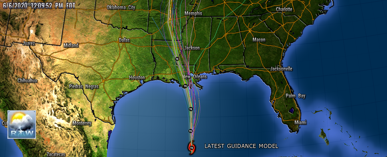
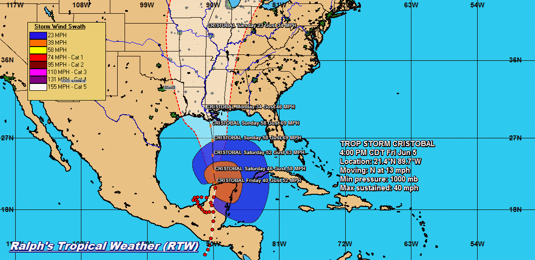
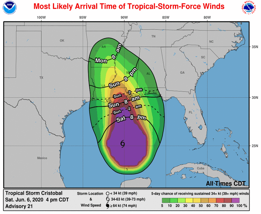
000
WTNT33 KNHC 062045
TCPAT3

BULLETIN
Tropical Storm Cristobal Advisory Number  21
NWS National Hurricane Center Miami FL       AL032020
400 PM CDT Sat Jun 06 2020

...WEATHER CONDITIONS EXPECTED TO DETERIORATE ALONG THE NORTHERN
GULF COAST TONIGHT...


SUMMARY OF 400 PM CDT...2100 UTC...INFORMATION
----------------------------------------------
LOCATION...25.2N 90.2W
ABOUT 280 MI...445 KM SSW OF THE MOUTH OF THE MISSISSIPPI RIVER
MAXIMUM SUSTAINED WINDS...50 MPH...85 KM/H
PRESENT MOVEMENT...N OR 360 DEGREES AT 12 MPH...19 KM/H
MINIMUM CENTRAL PRESSURE...994 MB...29.36 INCHES


WATCHES AND WARNINGS
--------------------
CHANGES WITH THIS ADVISORY:

None.

SUMMARY OF WATCHES AND WARNINGS IN EFFECT:

A Storm Surge Warning is in effect for...
* Mouth of the Mississippi River to Ocean Springs Mississippi
* Lake Borgne

A Storm Surge Watch is in effect for...
* East of Morgan City Louisiana to the mouth of the Mississippi
River

A Tropical Storm Warning is in effect for...
* Intracoastal City Louisiana to the Okaloosa/Walton County
Florida line
* Lake Pontchartrain and Lake Maurepas

A Storm Surge Warning means there is a danger of life-threatening
inundation, from rising water moving inland from the coastline,
during the next 36 hours in the indicated locations. For a depiction
of areas at risk, please see the National Weather Service Storm
Surge Watch/Warning Graphic, available at hurricanes.gov.  This is a
life-threatening situation.  Persons located within these areas
should take all necessary actions to protect life and property from
rising water and the potential for other dangerous conditions.
Promptly follow evacuation and other instructions from local
officials.

A Storm Surge Watch means there is a possibility of life-
threatening inundation, from rising water moving inland from the
coastline, in the indicated locations during the next 48 hours.

A Tropical Storm Warning means that tropical storm conditions are
expected somewhere within the warning area within the next 36 hours.

For storm information specific to your area, including possible
inland watches and warnings, please monitor products issued by your
local National Weather Service forecast office.


DISCUSSION AND OUTLOOK
----------------------
At 400 PM CDT (2100 UTC), the center of Tropical Storm Cristobal was
located near latitude 25.2 North, longitude 90.2 West. Cristobal is
moving toward the north near 12 mph (19 km/h) and this general
motion is expected to continue for the next day or so, followed by a
gradual turn toward the north-northwest.  On the forecast track, the
center of Cristobal will move northward over the central Gulf of
Mexico today and tonight, and will be near the northern Gulf of
Mexico coast on Sunday.  Cristobal's center is then forecast to move
inland across Louisiana late Sunday through Monday morning, and
northward across Arkansas and Missouri Monday afternoon into
Tuesday.

Maximum sustained winds remain near 50 mph (85 km/h) with higher 
gusts. Some slow strengthening is forecast until landfall occurs on
the northern Gulf coast.  Weakening will begin once Cristobal moves
inland late Sunday and Monday.

Tropical-storm-force winds extend outward up to 240 miles (390 km)
from the center.

The estimated minimum central pressure based on data from the Air 
Force Hurricane Hunters is 994 mb (29.36 inches).


HAZARDS AFFECTING LAND
----------------------
Key messages for Cristobal can be found in the Tropical Cyclone
Discussion under AWIPS header MIATCDAT3, WMO header WTNT43 KNHC, and
on the web at www.hurricanes.gov/text/MIATCDAT3.shtml

STORM SURGE:  The combination of a dangerous storm surge and the
tide will cause normally dry areas near the coast to be flooded by
rising waters moving inland from the shoreline.  The water could
reach the following heights above ground somewhere in the indicated
areas if the peak surge occurs at the time of high tide...

Mouth of the Mississippi River to Ocean Springs MS including Lake
Borgne...3-5 ft
Morgan City LA to Mouth of the Mississippi River...2-4 ft
Ocean Springs MS to Marco Island FL including Mobile Bay, Pensacola
Bay, and Tampa Bay...1-3 ft

The deepest water will occur along the immediate coast in areas of
onshore winds and will likely extend along the coast well to the
east of the center.  Surge-related flooding depends on the relative
timing of the surge and the tidal cycle, and can vary greatly over
short distances.  For information specific to your area, please see
products issued by your local National Weather Service forecast
office.

WIND: Tropical storm conditions are expected within the Tropical
Storm Warning area along the northern Gulf Coast beginning late
tonight or Sunday morning.

RAINFALL: Cristobal is expected to produce total rainfall
accumulations of 4 to 8 inches across the eastern and central Gulf
Coast into the Lower Mississippi Valley, with isolated amounts to 12
inches.   Isolated significant river flooding is possible along the
central Gulf Coast.  Rainfall totals of 2 to 4 inches, with local
amounts to 6 inches, are expected across the Mid-Mississippi Valley.
This rainfall may lead to flash flooding and widespread flooding on
smaller streams across the Mid-Mississippi Valley.

TORNADOES: Isolated tornadoes will be possible this afternoon and
evening across west central Florida, and early Sunday morning along
the north central and northeast Gulf coast.

SURF:  Swells generated by Cristobal will affect portions of the
northern and eastern Gulf coast during the next couple of days.
These swells are likely to cause life-threatening surf and rip
current conditions.  Please consult products from your local
weather office.


NEXT ADVISORY
-------------
Next intermediate advisory at 700 PM CDT.
Next complete advisory at 1000 PM CDT.

$$
Forecaster Pasch


 CENTER REMAINS VOID OF THUNDERSTORMS
 NO SHADES OF WHITE NEAR CENTER
 WATER VAPOR SATELLITE STILL SHOWS DRY AIR INTRUDING INTO INFLOW
 

TROPICAL STORM CRISTOBAL ENCOUNTERING DRY AIR INTRUSION

CRISTOBAL IS ENCOUNTERING DRY AIR INTRUSION ALONG THE WEST SIDE OF STORM.  THIS DRY AIR IS EN-TRAINING INTO THE INFLOW OF THE STORM AND IS HINDERING STRENGTHENING.  THERE IS ALSO AN UPPER LEVEL LOW THAT IS SHEARING STORMS AWAY FROM THE CENTER.  LACK OF THUNDERSTORMS AROUND THE CENTER OF CIRCULATION AND THE UPPER LEVEL SHEAR IS KEEPING THE STORMS FROM RAPPING AROUND THE CENTER.  THE STRONGEST THUNDERSTORMS ARE IN A VERTICAL LINE TO THE SOUTHEAST OF THE CENTER.  

RTW

000
WTNT33 KNHC 061448
TCPAT3

BULLETIN
Tropical Storm Cristobal Advisory Number  20
NWS National Hurricane Center Miami FL       AL032020
1000 AM CDT Sat Jun 06 2020

...CRISTOBAL CONTINUES MOVING NORTHWARD ACROSS THE SOUTH-CENTRAL
GULF OF MEXICO...


SUMMARY OF 1000 AM CDT...1500 UTC...INFORMATION
-----------------------------------------------
LOCATION...24.2N 90.1W
ABOUT 345 MI...555 KM S OF THE MOUTH OF THE MISSISSIPPI RIVER
MAXIMUM SUSTAINED WINDS...50 MPH...85 KM/H
PRESENT MOVEMENT...N OR 360 DEGREES AT 12 MPH...19 KM/H
MINIMUM CENTRAL PRESSURE...994 MB...29.36 INCHES


WATCHES AND WARNINGS
--------------------
CHANGES WITH THIS ADVISORY:

The Storm Surge Watch for the Florida Big Bend has been replaced
with coastal flood advisories and statements from local National
Weather Service offices.

A Tropical Storm Warning has been issued from Intracoastal City
to Morgan City Louisiana.

SUMMARY OF WATCHES AND WARNINGS IN EFFECT:

A Storm Surge Warning is in effect for...
* Mouth of the Mississippi River to Ocean Springs Mississippi
* Lake Borgne

A Storm Surge Watch is in effect for...
* East of Morgan City Louisiana to the mouth of the Mississippi
River

A Tropical Storm Warning is in effect for
* Intracoastal City Louisiana to the Okaloosa/Walton County
Florida line
* Lake Pontchartrain and Lake Maurepas

A Storm Surge Warning means there is a danger of life-threatening
inundation, from rising water moving inland from the coastline,
during the next 36 hours in the indicated locations. For a depiction
of areas at risk, please see the National Weather Service Storm
Surge Watch/Warning Graphic, available at hurricanes.gov.  This is a
life-threatening situation.  Persons located within these areas
should take all necessary actions to protect life and property from
rising water and the potential for other dangerous conditions.
Promptly follow evacuation and other instructions from local
officials.

A Storm Surge Watch means there is a possibility of life-
threatening inundation, from rising water moving inland from the
coastline, in the indicated locations during the next 48 hours.

A Tropical Storm Warning means that tropical storm conditions are
expected somewhere within the warning area within the next 36 hours.

For storm information specific to your area, including possible
inland watches and warnings, please monitor products issued by your
local National Weather Service forecast office.


DISCUSSION AND OUTLOOK
----------------------
At 1000 AM CDT (1500 UTC), the center of Tropical Storm Cristobal
was located near latitude 24.2 North, longitude 90.1 West.  
Cristobal is moving toward the north near 12 mph (19 km/h), and this 
general motion is expected to continue for the next day or so, 
followed by a gradual turn toward the north-northwest.  On the 
forecast track, the center of Cristobal will move northward over the 
central Gulf of Mexico today and tonight, and will be near the 
northern Gulf of Mexico coast on Sunday.  Cristobal's center is then 
forecast to move inland across Louisiana late Sunday through Monday 
morning, and northward across Arkansas and Missouri Monday 
afternoon into Tuesday.

Maximum sustained winds are near 50 mph (85 km/h) with higher gusts.
Some slow strengthening is forecast until landfall occurs on the
northern Gulf coast.  Weakening will begin once Cristobal moves
inland late Sunday and Monday.

Tropical-storm-force winds extend outward up to 240 miles (390 km)
from the center.

The minimum central pressure reported by an Air Force Hurricane 
Hunter aircraft is 994 mb (29.36 inches).


HAZARDS AFFECTING LAND
----------------------
Key messages for Cristobal can be found in the Tropical Cyclone
Discussion under AWIPS header MIATCDAT3, WMO header WTNT43 KNHC, and
on the web at www.hurricanes.gov/text/MIATCDAT3.shtml

STORM SURGE:  The combination of a dangerous storm surge and the
tide will cause normally dry areas near the coast to be flooded by
rising waters moving inland from the shoreline.  The water could
reach the following heights above ground somewhere in the indicated
areas if the peak surge occurs at the time of high tide...

Mouth of the Mississippi River to Ocean Springs MS including Lake
Borgne...3-5 ft
Morgan City LA to Mouth of the Mississippi River...2-4 ft
Ocean Springs MS to Marco Island FL including Mobile Bay, Pensacola 
Bay, and Tampa Bay...1-3 ft

The deepest water will occur along the immediate coast in areas of
onshore winds and will likely extend along the coast well to the
east of the center.  Surge-related flooding depends on the relative
timing of the surge and the tidal cycle, and can vary greatly over
short distances.  For information specific to your area, please see
products issued by your local National Weather Service forecast
office.

WIND: Tropical storm conditions are expected within the Tropical
Storm Warning area along the northern Gulf Coast beginning late
tonight or Sunday morning.

RAINFALL: Cristobal is expected to produce total rainfall
accumulations of 4 to 8 inches across the eastern and central Gulf
Coast into the Lower Mississippi Valley, with isolated amounts to 12
inches.   Isolated significant river flooding is possible along the
central Gulf Coast.  Rainfall totals of 2 to 4 inches, with local
amounts to 6 inches, are expected across the Mid-Mississippi Valley.
This rainfall may lead to flash flooding and widespread flooding on
smaller streams across the Lower to Mid-Mississippi Valley.

Additional rainfall totals of 1 to 3 inches are expected across the
Mexican states of Quintana Roo and Yucatan, bringing isolated storm
totals to 25 inches.  This will continue the threat of
life-threatening flash floods and mudslides.

TORNADOES: A few tornadoes may occur on Sunday across southern
Louisiana, southern Mississippi, southwest Alabama and the western
Florida Panhandle.

SURF:  Swells generated by Cristobal will affect portions of the
northern and eastern Gulf coast during the next few days.
These swells are likely to cause life-threatening surf and rip
current conditions.  Please consult products from your local
weather office.


NEXT ADVISORY
-------------
Next intermediate advisory at 100 PM CDT.
Next complete advisory at 400 PM CDT.

$$
Forecaster Pasch


Friday, June 5, 2020

TROPICAL STORM CRISTOBAL UPDATE 0400 PM EDT

788 
WTNT33 KNHC 052049
TCPAT3

BULLETIN
Tropical Storm Cristobal Advisory Number  17
NWS National Hurricane Center Miami FL       AL032020
400 PM CDT Fri Jun 05 2020

...STORM SURGE AND TROPICAL STORM WARNINGS ISSUED FOR THE NORTHERN
GULF COAST...


SUMMARY OF 400 PM CDT...2100 UTC...INFORMATION
----------------------------------------------
LOCATION...21.4N 89.7W
ABOUT 535 MI...860 KM S OF THE MOUTH OF THE MISSISSIPPI RIVER
MAXIMUM SUSTAINED WINDS...40 MPH...65 KM/H
PRESENT MOVEMENT...N OR 10 DEGREES AT 13 MPH...20 KM/H
MINIMUM CENTRAL PRESSURE...1000 MB...29.53 INCHES


WATCHES AND WARNINGS
--------------------
CHANGES WITH THIS ADVISORY:

A Storm Surge Warning has been issued for areas outside the 
Hurricane and Storm Damage Risk Reduction System from the mouth of 
the Mississippi River to Ocean Springs Mississippi, including Lake
Borgne.

A Tropical Storm Warning has been issued for the northern Gulf of
Mexico coast from east of Morgan City, Louisiana to the
Okaloosa/Walton County Florida line.

The Storm Surge Watch has been extended west of Grand Isle to east
of Morgan City Louisiana.

SUMMARY OF WATCHES AND WARNINGS IN EFFECT:

A Storm Surge Warning is in effect for...
* Mouth of the Mississippi River to Ocean Springs Mississippi
* Lake Borgne

A Storm Surge Watch is in effect for...
* Indian Pass to Arepika Florida
* East of Morgan City Louisiana to the mouth of the Mississippi
River

A Tropical Storm Warning is in effect for
* Punta Herrero to Rio Lagartos Mexico
* East of Morgan City, Louisiana to the Okaloosa/Walton County
Florida line
* Lake Pontchartrain and Lake Maurepas

A Tropical Storm Watch is in effect for...
* Intracoastal City Louisiana to Morgan City

A Storm Surge Warning means there is a danger of life-threatening 
inundation, from rising water moving inland from the coastline, 
during the next 36 hours in the indicated locations. For a depiction 
of areas at risk, please see the National Weather Service Storm 
Surge Watch/Warning Graphic, available at hurricanes.gov.  This is a 
life-threatening situation.  Persons located within these areas 
should take all necessary actions to protect life and property from 
rising water and the potential for other dangerous conditions.  
Promptly follow evacuation and other instructions from local 
officials.

A Storm Surge Watch means there is a possibility of life-
threatening inundation, from rising water moving inland from the
coastline, in the indicated locations during the next 48 hours.

A Tropical Storm Warning means that tropical storm conditions are
expected somewhere within the warning area within the next 36 hours.

A Tropical Storm Watch means that tropical storm conditions are
possible within the watch area, generally within 48 hours.

For storm information specific to your area in the United
States, including possible inland watches and warnings, please
monitor products issued by your local National Weather Service
forecast office. For storm information specific to your area
outside of the United States, please monitor products issued by
your national meteorological service.


DISCUSSION AND OUTLOOK
----------------------
At 400 PM CDT (2100 UTC), the center of Tropical Storm Cristobal was
located near latitude 21.4 North, longitude 89.7 West. Cristobal is
moving toward the north near 13 mph (20 km/h), and this general
motion is expected to continue for the next couple of days.  On the
forecast track, the center of Cristobal will move over the central 
Gulf of Mexico on Saturday, and be near the northern Gulf of 
Mexico coast on Sunday.  Cristobal's center is then forecast to move 
inland across Louisiana late Sunday and Monday.

Maximum sustained winds are near 40 mph (65 km/h) with higher gusts.
Some strengthening is forecast during the next 48 hours. Weakening 
will begin once Cristobal moves inland late Sunday and Monday.

Tropical-storm-force winds extend outward up to 240 miles (390 km) 
from the center.

The estimated minimum central pressure is 1000 mb (29.53 inches).


HAZARDS AFFECTING LAND
----------------------
Key messages for Cristobal can be found in the Tropical Cyclone
Discussion under AWIPS header MIATCDAT3, WMO header WTNT43 KNHC, and
on the web at www.hurricanes.gov/text/MIATCDAT3.shtml

STORM SURGE:  The combination of a dangerous storm surge and the
tide will cause normally dry areas near the coast to be flooded by
rising waters moving inland from the shoreline.  The water could
reach the following heights above ground somewhere in the indicated
areas if the peak surge occurs at the time of high tide...

Mouth of the Mississippi River to Ocean Springs MS including Lake
Borgne...3-5 ft
Ocean Springs MS to Indian Pass FL including Mobile Bay and 
Pensacola Bay...1-3 ft
Indian Pass FL to Aripeka FL...2-4 ft
Aripeka FL to Marco Island FL including Tampa Bay...1-3 ft
Morgan City LA to the Mouth of the Mississippi River...2-4 ft

The deepest water will occur along the immediate coast in areas of
onshore winds and will likely extend along the coast well to the
east of the center.  Surge-related flooding depends on the relative
timing of the surge and the tidal cycle, and can vary greatly over
short distances.  For information specific to your area, please see
products issued by your local National Weather Service forecast
office.

WIND: Tropical storm conditions are expected to continue in portions
of the Tropical Storm Warning area along the Yucatan Peninsula
during the next few hours.  Tropical storm conditions are expected
within the Tropical Storm Warning area along the northern Gulf
Coast beginning late Saturday night.  Tropical storm conditions are
possible within the watch area on Sunday.

RAINFALL: Cristobal is expected to produce the following rain
accumulations:

Through Wednesday morning, for portions of the eastern and central
Gulf Coast and the lower Mississippi Valley, rainfall accumulations
of 4 to 8 inches, with local amounts to 12 inches, are forecast.
Isolated significant river flooding is possible along the central
Gulf Coast.  Farther north across the mid-Mississippi Valley,
rainfall totals of 2 to 4 inches, with local amounts to 6 inches,
are expected.  This degree of rainfall is expected to lead to flash
flooding, and widespread flooding on smaller streams is possible 
across the mid-Mississippi Valley.

Mexican states of Campeche, Quintana Roo, and Yucatan...Additional 4
to 6 inches, isolated storm totals of 25 inches.

Belize and the Mexican states of Tabasco and Oaxaca...Additional 4
to 6 inches, isolated storm totals of 12 inches.

Southern Guatemala, coastal portions of Chiapas, and El
Salvador...Additional 4 to 6 inches, isolated storm total amounts of
35 inches dating back to Saturday, May 30th.

Southern parts of Honduras...Additional 3 to 4 inches, isolated 8
inches.

Rainfall across Southeast Mexico and northern Central America would
continue the risk of life-threatening flash floods and mudslides.

SURF:  Swells generated by Cristobal will affect portions of the
northern and eastern Gulf coast during the next few days.  These
swells are likely to cause life-threatening surf and rip current
conditions.  Please consult products from your local weather office.


NEXT ADVISORY
-------------
Next intermediate advisory at 700 PM CDT.
Next complete advisory at 1000 PM CDT.

$$
Forecaster Pasch/Berg 


CRISTOBAL A POTENTIAL FLOOD THREAT FOR THE NORTH GULF STATES

CRISTOBAL UPDATE 1000 AM EDT

000
WTNT33 KNHC 051447
TCPAT3

BULLETIN
Tropical Depression Cristobal Advisory Number  16
NWS National Hurricane Center Miami FL       AL032020
1000 AM CDT Fri Jun 05 2020

...STORM SURGE AND TROPICAL STORM WATCHES ISSUED FOR PORTIONS OF 
THE NORTHERN GULF OF MEXICO COAST...


SUMMARY OF 1000 AM CDT...1500 UTC...INFORMATION
-----------------------------------------------
LOCATION...20.0N 89.9W
ABOUT 40 MI...65 KM E OF CAMPECHE MEXICO
MAXIMUM SUSTAINED WINDS...35 MPH...55 KM/H
PRESENT MOVEMENT...N OR 360 DEGREES AT 12 MPH...19 KM/H
MINIMUM CENTRAL PRESSURE...1000 MB...29.53 INCHES


WATCHES AND WARNINGS
--------------------
CHANGES WITH THIS ADVISORY:

A Storm Surge Watch has been issued for the northern Gulf of Mexico
coast from Indian Pass to Arepika, Florida, and from Grand Isle,
Louisiana, to Ocean Springs, Mississippi, including Lake Borgne.

A Tropical Storm Watch has been issued for the northern Gulf of
Mexico coast from Intracoastal City Louisiana to the
Alabama/Florida border, including Lake Pontchartrain and Lake
Maurepas.

SUMMARY OF WATCHES AND WARNINGS IN EFFECT:

A Storm Surge Watch is in effect for...
* Indian Pass to Arepika Florida
* Grand Isle Louisiana to Ocean Springs Mississippi
* Lake Borgne

A Tropical Storm Watch is in effect for...
* Intracoastal City Louisiana to the Alabama/Florida border
* Lake Pontchartrain and Lake Maurepas
* Punta Herrero to Rio Lagartos Mexico

A Storm Surge Watch means there is a possibility of life-
threatening inundation, from rising water moving inland from the
coastline, in the indicated locations during the next 48 hours.
For a depiction of areas at risk, please see the National Weather
Service Storm Surge Watch/Warning Graphic, available at
hurricanes.gov.

A Tropical Storm Watch means that tropical storm conditions are
possible within the watch area, generally within 48 hours.
Tropical storm conditions in the watch area in Mexico could occur
through this afternoon.

For storm information specific to your area in the United States, 
including possible inland watches and warnings, please monitor 
products issued by your local National Weather Service forecast 
office. For storm information specific to your area outside of the 
United States, please monitor products issued by your national 
meteorological service.


DISCUSSION AND OUTLOOK
----------------------
At 1000 AM CDT (1500 UTC), the center of Tropical Depression
Cristobal was located near latitude 20.0 North, longitude 89.9 West.
The depression is moving toward the north near 12 mph (19 km/h), and
this general motion is expected to continue for the next couple of 
days.  On the forecast track, the center will move back over the 
southern Gulf of Mexico this evening, over the central Gulf of 
Mexico on Saturday, and be near the northern Gulf of Mexico coast 
Sunday evening.

Maximum sustained winds are near 35 mph (55 km/h) with higher gusts.
Some strengthening is forecast during the next 48 hours, and 
Cristobal is expected to regain tropical storm strength later 
today.  Some additional strengthening is forecast thereafter.

The estimated minimum central pressure is 1000 mb (29.53 inches).


HAZARDS AFFECTING LAND
----------------------
Key messages for Cristobal can be found in the Tropical Cyclone
Discussion under AWIPS header MIATCDAT3, WMO header WTNT43 KNHC, and
on the web at www.hurricanes.gov/text/MIATCDAT3.shtml

STORM SURGE:  The combination of a dangerous storm surge and the
tide will cause normally dry areas near the coast to be flooded by
rising waters moving inland from the shoreline.  The water could
reach the following heights above ground somewhere in the indicated
areas if the peak surge occurs at the time of high tide...

Aripeka to Marco Island including Tampa Bay...1-3 ft
Grand Isle to Ocean Springs including Lake Borgne...2-4 ft
Indian Pass to Aripeka...2-4 ft
Ocean Springs to Indian Pass including Mobile Bay and Pensacola
Bay...1-3 ft

The deepest water will occur along the immediate coast in areas of
onshore winds and will likely extend along the coast well to the
east of the center.  Surge-related flooding depends on the relative
timing of the surge and the tidal cycle, and can vary greatly over
short distances.  For information specific to your area, please see
products issued by your local National Weather Service forecast
office.

WIND: Tropical storm conditions are possible today within the
Tropical Storm Watch area of the Yucatan Peninsula.  Tropical
storm conditions are possible within the Tropical Storm Watch area
of the northern Gulf coast beginning early Sunday.

RAINFALL: Cristobal is expected to produce the following rain
accumulations:

Through Wednesday morning, for portions of the eastern and central
Gulf Coast and the lower Mississippi Valley, rainfall accumulations
of 4 to 8 inches, with local amounts to 12 inches, are forecast.
Isolated significant river flooding is possible along the central
Gulf Coast.  Farther north across the Mid-Mississippi Valley,
rainfall totals of 2 to 4 inches, with local amounts to 6 inches,
are expected.  Rises along smaller-order streams are possible
across the Mid-Mississippi Valley. This degree of rainfall is
expected to lead to flash flooding.

Mexican states of Campeche, Quintana Roo, and Yucatan...Additional 4
to 6 inches, isolated storm totals of 25 inches.

Belize and the Mexican states of Tabasco and Oaxaca...Additional 4
to 6 inches, isolated storm totals of 12 inches.

Southern Guatemala, coastal portions of Chiapas, and El
Salvador...Additional 4 to 6 inches, isolated storm total amounts of
35 inches dating back to Saturday, May 30th.

Southern parts of Honduras...Additional 3 to 4 inches, isolated 8
inches.

Rainfall across Southeast Mexico and northern Central America would
continue the risk of life-threatening flash floods and mudslides.

SURF:  Swells generated by Cristobal will affect portions of the
northern and eastern Gulf coast during the next few days.  These
swells are likely to cause life-threatening surf and rip current
conditions.  Please consult products from your local weather office.


NEXT ADVISORY
-------------
Next intermediate advisory at 100 PM CDT.
Next complete advisory at 400 PM CDT.

$$
Forecaster Pasch