Thursday, September 21, 2023

..POTENTIAL TROPICAL CYCLONE SIXTEEN UPDATE 0500 PM EDT SEPT. 21, 2023..


...LOW EXPECTED TO STRENGTHEN OFF THE SOUTHEAST U.S. COAST AND BRING TROPICAL STORM CONDITIONS AND THE POTENTIAL FOR LIFE-THREATENING STORM SURGE BEGINNING ON FRIDAY...
5:00 PM EDT Thu Sep 21
Location: 29.2°N 75.9°W
Moving: N at 8 mph
Min pressure: 1012 mb
Max sustained: 35 mph


..POTENTIAL TROPICAL CYCLONE SIXTEEN FORMS OVER THE WEST ATLANTIC, SEPT. 21, 2023..


...LOW PRESSURE AREA EXPECTED TO BRING TROPICAL STORM CONDITIONS AND THE POTENTIAL FOR LIFE-THREATENING STORM SURGE TO PORTIONS OF THE SOUTHEAST AND MID-ATLANTIC COASTS...
11:00 AM EDT Thu Sep 21
Location: 28.7°N 75.9°W
Moving: N at 9 mph
Min pressure: 1012 mb
Max sustained: 35 mph


..TROPICAL WEATHER OUTLOOK SEPT. 21, 2023..


Invest 99L off the East coast of Florida has a potential to become a tropical or sub-tropical storm by tomorrow or over the weekend. This system is forecast to move north along east coast bringing tropical storm wind gusts, heavy rains up and coastal flooding up the eastern seaboard.  Monitor the National Hurricane Center for the latest on this system.  

000

ABNT20 KNHC 211356 CCA
TWOAT 

Special Tropical Weather Outlook...Corrected
NWS National Hurricane Center Miami FL
1000 AM EDT Thu Sep 21 2023

Corrrected time in the product

For the North Atlantic...Caribbean Sea and the Gulf of Mexico:

Special outlook issued to raise probabilities and update discussion 

Active Systems:
The National Hurricane Center is issuing advisories on Hurricane 
Nigel, located over the central subtropical Atlantic.

Off the Southeastern United States Coast (AL99):
Updated...A trough of low pressure located several hundred miles 
east of the Florida peninsula continues to produce a large area of 
disorganized showers and thunderstorms. A non-tropical low pressure 
system is expected to form within this area by early Friday, and 
there are increasing chances that this system could acquire some 
tropical or subtropical characteristics on Friday or early Saturday 
while it moves generally northward toward the coast of North 
Carolina. Regardless of tropical or subtropical development, this 
low is likely to bring tropical storm force winds, heavy rain, 
coastal flooding, and high surf to portions of the southeast and 
mid-Atlantic United States coastline on Friday and into the 
weekend. Tropical Storm watches or warnings could be required for 
this system as soon as later this morning. Additional information on 
this system, including storm and gale warnings, can be found in High 
Seas Forecasts and products from your local National Weather Service 
office.
* Formation chance through 48 hours...medium...50 percent.
* Formation chance through 7 days...medium...50 percent.

Eastern Tropical Atlantic:
A tropical wave located just west of the Cabo Verde Islands is 
producing some disorganized shower and thunderstorm activity. 
Environmental conditions are forecast to be conducive for gradual 
development of this system, and a tropical depression is likely to 
form this weekend or early next week while the system moves 
generally westward at 10 to 15 mph across the eastern and central 
tropical Atlantic.
* Formation chance through 48 hours...low...20 percent.
* Formation chance through 7 days...high...70 percent.

&&

High Seas Forecasts issued by the National Weather Service
can be found under AWIPS header NFDHSFAT1, WMO header FZNT01 
KWBC, and online at ocean.weather.gov/shtml/NFDHSFAT1.php

$$
Forecaster Reinhart/Brown


Wednesday, September 20, 2023

..TROPICAL WEATHER OUTLOOK SEPT 20, 2023..


000
ABNT20 KNHC 201746
TWOAT 

Tropical Weather Outlook
NWS National Hurricane Center Miami FL
200 PM EDT Wed Sep 20 2023

For the North Atlantic...Caribbean Sea and the Gulf of Mexico:

Active Systems:
The National Hurricane Center is issuing advisories on Hurricane 
Nigel, located over the central subtropical Atlantic.

Eastern Tropical Atlantic:
A tropical wave is currently located a couple of hundred miles 
southeast of the Cabo Verde Islands.  This system is expected 
to merge with another disturbance located a few hundred miles to its 
west in a few days.  Environmental conditions are forecast to 
be conducive for gradual development, and a tropical depression is 
likely to form late this week or this weekend while the system moves 
generally westward at 10 to 15 mph across the eastern and central 
tropical Atlantic.
* Formation chance through 48 hours...low...10 percent.
* Formation chance through 7 days...high...70 percent.

Western Atlantic:
A non-tropical low pressure system is expected to form within a 
large area of disorganized showers and thunderstorms to the east 
of the Florida peninsula within the next day or two.  This system 
could acquire some subtropical characteristics on Friday while it 
moves generally northward.  Regardless of development, this low is 
likely to bring gusty winds to gale force, heavy rain, and high surf 
to portions of the Southeast and Mid-Atlantic United States late 
this week and into this weekend.  Additional information on this 
system can be found in High Seas Forecasts and products from your 
local National Weather Service office.
* Formation chance through 48 hours...low...10 percent.
* Formation chance through 7 days...medium...40 percent.

&&

High Seas Forecasts issued by the National Weather Service
can be found under AWIPS header NFDHSFAT1, WMO header FZNT01 
KWBC, and online at ocean.weather.gov/shtml/NFDHSFAT1.php

$$
Forecaster Pasch


Tuesday, September 19, 2023

..TROPICAL WEATHER OUTLOOK SEPT. 19, 2023..


000
ABNT20 KNHC 191732
TWOAT 

Tropical Weather Outlook
NWS National Hurricane Center Miami FL
200 PM EDT Tue Sep 19 2023

For the North Atlantic...Caribbean Sea and the Gulf of Mexico:

Active Systems:
The National Hurricane Center is issuing advisories on Hurricane 
Nigel, located over the central subtropical Atlantic.

Eastern Tropical Atlantic:
A tropical wave is expected to move off the west coast of Africa by 
Wednesday.  Environmental conditions are forecast to be conducive 
for gradual development of the wave thereafter, and a tropical 
depression is likely to form late this week or this weekend while 
the system moves generally westward across the eastern and central 
tropical Atlantic.
* Formation chance through 48 hours...low...near 0 percent.
* Formation chance through 7 days...high...70 percent.

Western Atlantic:
A non-tropical area of low pressure is expected to form east of the 
Florida peninsula late this week.  This system could acquire some 
subtropical characteristics this weekend while it moves 
generally northward.  Regardless of subtropical development, this 
low is likely to bring gusty winds, heavy rain, and high surf 
conditions to portions of the coastal Carolinas into the coastal 
Mid-Atlantic states late this week into this weekend.  Please see 
products from your local National Weather Service office for more 
details.
* Formation chance through 48 hours...low...near 0 percent.
* Formation chance through 7 days...low...30 percent.

$$
Forecaster Hagen/Reinhart


Friday, September 15, 2023

..HURRICANE LEE UPDATE SEPT. 15, 2023..

...LEE REMAINS A LARGE HURRICANE OVER THE WESTERN ATLANTIC... ...TROPICAL STORM CONDITIONS EXPECTED TO BEGIN ACROSS PARTS OF COASTAL NEW ENGLAND LATER THIS AFTERNOON...
11:00 AM AST Fri Sep 15
Location: 36.0°N 66.9°W
Moving: NNE at 18 mph
Min pressure: 962 mb
Max sustained: 80 mph


Lee is moving through an unfavorable wind shear environment. 
 

Dry air is also entering Lee's flow.


..TROPICAL WEATHER OUTLOOK SEPT. 15, 2023..


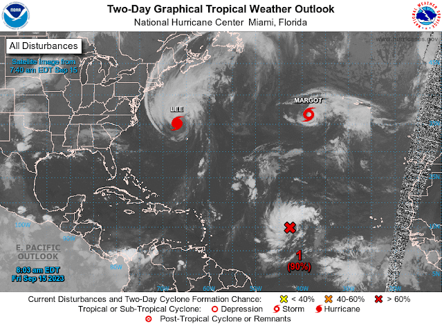
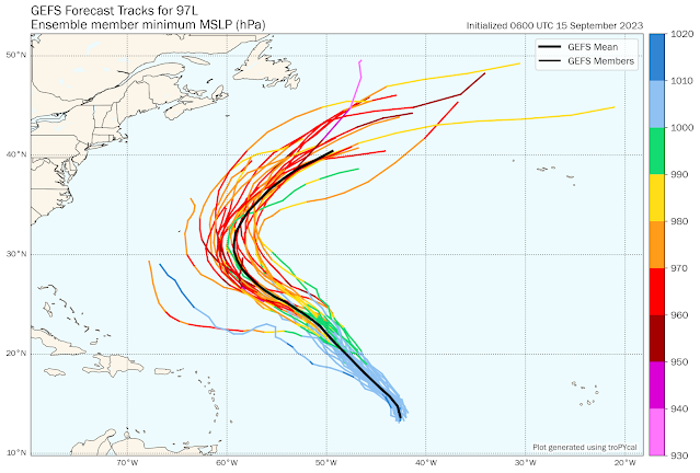
Storm Investigation 97L has a 90–90% formation chance and will more than likely be the next hurricane in the Atlantic. As it is, this storm system is scheduled to recurve over the North Atlantic and is not a threat to the U.S. mainland. 

The other storm investigation behind 97L presently has a 0–20% chance of formation. I will monitor this system since it could track further west and maybe into the eastern Caribbean.

Refer to the National Hurricane Center for the latest updates.

RTW

ZCZC MIATWOAT ALL
TTAA00 KNHC DDHHMM

Tropical Weather Outlook
NWS National Hurricane Center Miami FL
800 AM EDT Fri Sep 15 2023

For the North Atlantic...Caribbean Sea and the Gulf of Mexico:

Active Systems:
The National Hurricane Center is issuing advisories on Hurricane 
Lee, located several hundred miles south-southeast of the New 
England states, and on Hurricane Margot, located over the central 
Atlantic.

1. Central Tropical Atlantic (AL97):
Showers and thunderstorms have become better organized in 
association with a broad low pressure area located about midway 
between the Cabo Verde Islands and the Lesser Antilles. 
Environmental conditions remain conducive for additional 
development, and this system is expected to become a tropical 
depression within the next day or so while it moves 
west-northwestward to northwestward at 10 to 15 mph across the 
central tropical Atlantic. For additional information on this 
system, including gale warnings, see High Seas Forecasts issued by 
the National Weather Service.
* Formation chance through 48 hours...high...90 percent.
* Formation chance through 7 days...high...90 percent. 

2. Eastern Tropical Atlantic:
A tropical wave is forecast to move off the west coast of Africa by 
the middle part of next week. Some gradual development of this 
system is possible thereafter while the system moves westward across 
the eastern tropical Atlantic.
* Formation chance through 48 hours...low...near 0 percent.
* Formation chance through 7 days...low...20 percent.

High Seas Forecasts issued by the National Weather Service
can be found under AWIPS header NFDHSFAT1, WMO header FZNT01 
KWBC, and online at ocean.weather.gov/shtml/NFDHSFAT1.php

Forecaster Bucci