.jpg)
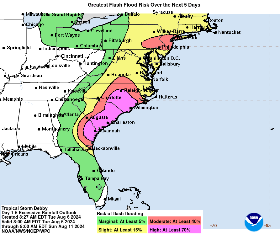
| ...DEBBY MOVES FARTHER INLAND OVER SOUTH CAROLINA... ...MAJOR FLOOD THREAT CONTINUES FOR PORTIONS OF THE CAROLINAS AND WESTERN VIRGINIA... | |||||||
| 8:00 AM EDT Thu Aug 8 Location: 34.1°N 79.9°W Moving: NW at 7 mph Min pressure: 995 mb Max sustained: 45 mph | |||||||


| ...DEBBY MOVES FARTHER INLAND OVER SOUTH CAROLINA... ...MAJOR FLOOD THREAT CONTINUES FOR PORTIONS OF THE CAROLINAS AND WESTERN VIRGINIA... | |||||||
| 8:00 AM EDT Thu Aug 8 Location: 34.1°N 79.9°W Moving: NW at 7 mph Min pressure: 995 mb Max sustained: 45 mph | |||||||

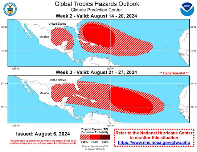
The tropical wave in the Caribbean has a low chance for formation (0-10% chance for development).
As for the rest of the Atlantic, according to the latest Global Tropics Hazards Outlook, the Atlantic is going to get busy in August. Possible development areas are rather concerning for the Southeast U.S., so we all need to monitor the National Hurricane Center for new storm investigations in the coming weeks.
RTW
ZCZC MIATWOAT ALL
TTAA00 KNHC DDHHMM

Tropical Weather Outlook
NWS National Hurricane Center Miami FL
800 AM EDT Wed Aug 7 2024

For the North Atlantic...Caribbean Sea and the Gulf of Mexico:

Active Systems:
The National Hurricane Center is issuing advisories on Tropical
Storm Debby, located just offshore of the Georgia and South
Carolina coastline.

1. Southwestern Gulf of Mexico:
Disorganized showers and thunderstorms located over the
southwestern Caribbean sea are associated with a tropical wave.
The northern portion of this tropical wave could reach the
southwestern Gulf of Mexico over the weekend, however, any
development of this system should be slow to occur.
* Formation chance through 48 hours...low...near 0 percent.
* Formation chance through 7 days...low...10 percent.


Forecaster Roberts
-----------------------------------------------------------------------
321 ACCA62 KNHC 071126 TWOSAT Perspectiva sobre las Condiciones del Tiempo en el Trópico Centro Nacional de Huracanes del SNM Miami FL 800 AM EDT miércoles 7 de agosto de 2024 Para el Atlántico Norte...Mar Caribe y el Golfo de México: Sistemas Activos: El Centro Nacional de Huracanes está emitiendo advertencias sobre la Tormenta Tropical Debby, ubicada justo en alta mar de la costa de Georgia y Carolina del Sur. Suroeste del Golfo de México: Aguaceros y tormentas eléctricas desorganizadas localizadas sobre el mar suroeste del Caribe están associados con una onda tropical. La porción norte de esta onda tropical podría alcanzar el suroeste del Golfo de México durante el fin de semana, sin embargo, cualquier desarrollo de este sistema debe ser lento. * Probabilidad de formación hasta 48 horas...baja...cerca del 0 por ciento. * Probabilidad de formación hasta 7 días...baja...10 por ciento. $$ Pronosticador Roberts *** Este producto ha sido procesado automáticamente utilizando un programa de traducción y puede contener omisiones y errores. El Servicio Nacional de Meteorología no puede garantizar la precisión del texto convertido. De haber alguna duda, el texto en inglés es siempre la versión autorizada. ***Look at the large storm system over the African continent and all the moisturemoving into the Atlantic suppressing the Saharan dry air and dust.
.jpg)
| ...DEBBY MOVING SLOWLY NORTHEASTWARD OFF THE SOUTH CAROLINA COAST... ...MAJOR FLOOD THREAT CONTINUES FOR PORTIONS OF THE CAROLINAS... | |||||||
| 8:00 AM EDT Wed Aug 7 Location: 32.2°N 79.4°W Moving: NE at 4 mph Min pressure: 995 mb Max sustained: 45 mph | |||||||


.gif)

.jpg)
| ...DEBBY MOVING VERY SLOWLY NEAR THE COASTS OF GEORGIA AND SOUTH CAROLINA... ...DANGEROUS FLOOD THREAT OVER PORTIONS OF THE SOUTHEASTERN UNITED STATES THIS WEEK... | |||||||
| 2:00 PM EDT Tue Aug 6 Location: 32.0°N 80.9°W Moving: ENE at 5 mph Min pressure: 999 mb Max sustained: 40 mph | |||||||


.gif)


.jpg)
Power companies are working as quickly as they can to restore electricity in areas that are safe to do so. It's a tedious job working through flooded roads and obstructed roads by fallen debris. Please stay off the roads so crews can clean up and workers can get their job done. It is also dangerous since many roads and towns are flooded where low vehicles cannot pass safely through.
RTW

| ...DEBBY EXPECTED TO MEANDER NEAR THE SOUTH CAROLINA COAST DURING THE NEXT COUPLE OF DAYS... ...SERIOUS FLOOD THREAT OVER PORTIONS OF THE SOUTHEASTERN UNITED STATES THIS WEEK... | |||||||
| 11:00 AM EDT Tue Aug 6 Location: 31.9°N 81.0°W Moving: ENE at 6 mph Min pressure: 999 mb Max sustained: 40 mph | |||||||


As for the tropical wave being monitored in the Caribbean with a low chance for formation, it has Saharan dust and dry air traveling along with this wave. It is not looking very healthy at this time.
RTW
ZCZC MIATWOAT ALL
TTAA00 KNHC DDHHMM

Tropical Weather Outlook
NWS National Hurricane Center Miami FL
800 AM EDT Tue Aug 6 2024

For the North Atlantic...Caribbean Sea and the Gulf of Mexico:

Active Systems:
The National Hurricane Center is issuing advisories on Tropical
Storm Debby, located near the Georgia coastline.

1. Western Caribbean Sea and Southwestern Gulf of Mexico:
Showers and thunderstorms associated with a tropical wave located
over the east-central Caribbean Sea have changed little this
morning.  Any development of this system should be slow to occur
during the next couple of days while it moves westward over the
central Caribbean Sea.  Environmental conditions are expected to
become more conducive for development later this week as the system
moves across the western Caribbean Sea or the southern Gulf of
Mexico.
* Formation chance through 48 hours...low...10 percent.
* Formation chance through 7 days...low...30 percent.


Forecaster Hogsett
--------------------------------------------------------------------
658
ACCA62 KNHC 061107
TWOSAT

Perspectiva sobre las Condiciones del Tiempo en el Trópico
Centro Nacional de Huracanes del SNM Miami FL
800 AM EDT martes 6 de agosto de 2024

Para el Atlántico Norte...Mar Caribe y el Golfo de México:

Sistemas Activos: El Centro Nacional de Huracanes está emitiendo
advertencias sobre la Tormenta Tropical Debby, ubicada cerca de la
costa de Georgia.

Mar Caribe Occidental y el suroeste del Golfo de México: Aguaceros y
tormentas eléctricas associadas con una onda tropical localizada
sobre el Mar Caribe este y el centro han cambiado poco esta mañana.
Cualquier desarrollo de este sistema debe ser lento durante los
próximos dos días mientras se mueve hacia el oeste sobre el Mar
Caribe central. Se espera que las condiciones ambientales se vuelvan
más propicias para el desarrollo más tarde esta semana a medida que
el sistema se mueve a través del Mar Caribe occidental o el sur del
Golfo de México.
* Probabilidad de formación hasta 48 horas...baja...10 por ciento.
* Probabilidad de formación hasta 7 días...baja...30 por ciento.

$$
Pronosticador Hogsett

*** Este producto ha sido procesado automáticamente utilizando un
programa de traducción y puede contener omisiones y errores. El
Servicio Nacional de Meteorología no puede garantizar la precisión
del texto convertido. De haber alguna duda, el texto en inglés es
siempre la versión autorizada. ***