
Saturday, January 21, 2017
AS EAST COAST LINE OF STORM MOVES OUT THE NEXT LINE CRANKS UP
AS EAST COAST LINE OF STORMS MOVES OUT THE NEXT LINE CRANKS UP ALONG EAST TEXAS LOUISIANA, ARKANSAS EASTWARD.
HERE ARE THE LATEST TORNADO WATCH BOXES AND AVIATION TORNADO WATCH BOX IN PINK COLOR:


HERE ARE THE LATEST TORNADO WATCH BOXES AND AVIATION TORNADO WATCH BOX IN PINK COLOR:
URGENT - IMMEDIATE BROADCAST REQUESTED
   Tornado Watch Number 16
   NWS Storm Prediction Center Norman OK
   340 PM CST Sat Jan 21 2017

   The NWS Storm Prediction Center has issued a

   * Tornado Watch for portions of
     Southern Arkansas
     Northern Louisiana
     Extreme Southeast Oklahoma
     Northeast Texas

   * Effective this Saturday afternoon and evening from 340 PM until
     900 PM CST.

   * Primary threats include...
     A few tornadoes possible
     Widespread large hail and isolated very large hail events to 3
       inches in diameter likely
     Scattered damaging wind gusts to 70 mph possible

   SUMMARY...Thunderstorms will form soon over northeast TX and spread
   across the watch area this afternoon and evening.  Supercells
   capable of very large hail and a few tornadoes are expected.

   The tornado watch area is approximately along and 75 statute miles
   east and west of a line from 50 miles north northwest of Hot Springs
   AR to 35 miles south southwest of Natchitoches LA. For a complete
   depiction of the watch see the associated watch outline update
   (WOUS64 KWNS WOU6).

   PRECAUTIONARY/PREPAREDNESS ACTIONS...

   REMEMBER...A Tornado Watch means conditions are favorable for
   tornadoes and severe thunderstorms in and close to the watch
   area. Persons in these areas should be on the lookout for
   threatening weather conditions and listen for later statements
   and possible warnings.

   &&

   OTHER WATCH INFORMATION...CONTINUE...WW 13...WW 14...WW 15...

   AVIATION...Tornadoes and a few severe thunderstorms with hail
   surface and aloft to 3 inches. Extreme turbulence and surface wind
   gusts to 60 knots. A few cumulonimbi with maximum tops to 450. Mean
   storm motion vector 25035.

   ...Hart
-------------------------------------------------
 URGENT - IMMEDIATE BROADCAST REQUESTED
   Tornado Watch Number 15
   NWS Storm Prediction Center Norman OK
   330 PM CST Sat Jan 21 2017

   The NWS Storm Prediction Center has issued a

   * Tornado Watch for portions of
     Southeast Louisiana
     Southern Mississippi
     Coastal Waters

   * Effective this Saturday afternoon and evening from 330 PM until
     900 PM CST.

   * Primary threats include...
     A few tornadoes and a couple intense tornadoes possible
     Scattered large hail likely with isolated very large hail events
       to 2.5 inches in diameter possible
     Isolated damaging wind gusts to 70 mph possible

   SUMMARY...Thunderstorms are expected to develop over southeast LA
   this afternoon and spread northeastward across the watch area.
   Large hail and damaging winds are possible in this area, but the
   risk of a few tornadoes should increase by early evening.

   The tornado watch area is approximately along and 70 statute miles
   north and south of a line from 10 miles south of Alexandria LA to 35
   miles east southeast of Gulfport MS. For a complete depiction of the
   watch see the associated watch outline update (WOUS64 KWNS WOU5).

   PRECAUTIONARY/PREPAREDNESS ACTIONS...

   REMEMBER...A Tornado Watch means conditions are favorable for
   tornadoes and severe thunderstorms in and close to the watch
   area. Persons in these areas should be on the lookout for
   threatening weather conditions and listen for later statements
   and possible warnings.

   &&

   OTHER WATCH INFORMATION...CONTINUE...WW 13...WW 14...

   AVIATION...Tornadoes and a few severe thunderstorms with hail
   surface and aloft to 2.5 inches. Extreme turbulence and surface wind
   gusts to 60 knots. A few cumulonimbi with maximum tops to 450. Mean
   storm motion vector 24030.

   ...Hart
---------------------------------------------
 URGENT - IMMEDIATE BROADCAST REQUESTED
   Tornado Watch Number 14
   NWS Storm Prediction Center Norman OK
   210 PM EST Sat Jan 21 2017

   The NWS Storm Prediction Center has issued a

   * Tornado Watch for portions of
     Florida Panhandle
     South Central Georgia
     Coastal Waters

   * Effective this Saturday afternoon and evening from 210 PM until
     700 PM EST.

   * Primary threats include...
     A couple tornadoes possible
     Isolated damaging wind gusts to 70 mph possible
     Isolated large hail events to 1.5 inches in diameter possible

   SUMMARY...A line of strong to severe thunderstorms will sag
   southward across the watch area this afternoon.  Strong winds aloft
   and sufficient instability suggest a risk of locally gusty or
   damaging winds and isolated tornadoes.

   The tornado watch area is approximately along and 40 statute miles
   north and south of a line from 40 miles west northwest of
   Apalachicola FL to 25 miles north northeast of Valdosta GA. For a
   complete depiction of the watch see the associated watch outline
   update (WOUS64 KWNS WOU4).

   PRECAUTIONARY/PREPAREDNESS ACTIONS...

   REMEMBER...A Tornado Watch means conditions are favorable for
   tornadoes and severe thunderstorms in and close to the watch
   area. Persons in these areas should be on the lookout for
   threatening weather conditions and listen for later statements
   and possible warnings.

   &&

   OTHER WATCH INFORMATION...CONTINUE...WW 12...WW 13...

   AVIATION...Tornadoes and a few severe thunderstorms with hail
   surface and aloft to 1.5 inches. Extreme turbulence and surface wind
   gusts to 60 knots. A few cumulonimbi with maximum tops to 450. Mean
   storm motion vector 26030.

   ...Hart


HAZARDOUS WEATHER OUTLOOK FOR SOUTH FLORIDA DAY-1 AND 2

FLUS42 KMFL 211418
HWOMFL

HAZARDOUS WEATHER OUTLOOK FOR SOUTH FLORIDA
NATIONAL WEATHER SERVICE MIAMI FL
918 AM EST SAT JAN 21 2017

AMZ610-630-650-651-670-671-FLZ063-066>075-168-172>174-GMZ656-657-676-
220230-
LAKE OKEECHOBEE-BISCAYNE BAY-
COASTAL WATERS FROM JUPITER INLET TO DEERFIELD BEACH FL OUT 20 NM-
COASTAL WATERS FROM DEERFIELD BEACH TO OCEAN REEF FL OUT 20 NM-
WATERS FROM JUPITER INLET TO DEERFIELD BEACH FL FROM 20 TO 60 NM-
WATERS FROM DEERFIELD BEACH TO OCEAN REEF FL FROM 20 TO 60 NM
EXCLUDING THE TERRITORIAL WATERS OF BAHAMAS-GLADES-HENDRY-
INLAND PALM BEACH-METRO PALM BEACH-COASTAL COLLIER-INLAND COLLIER-
INLAND BROWARD-METRO BROWARD-INLAND MIAMI-DADE-METRO MIAMI-DADE-
MAINLAND MONROE-COASTAL PALM BEACH-COASTAL BROWARD-COASTAL MIAMI-
DADE-FAR SOUTH MIAMI-DADE-
COASTAL WATERS FROM CHOKOLOSKEE TO BONITA BEACH FL OUT 20 NM-
COASTAL WATERS FROM EAST CAPE SABLE TO CHOKOLOSKEE FL OUT 20 NM-
WATERS FROM CHOKOLOSKEE TO BONITA BEACH FL FROM 20 TO 60 NM-
918 AM EST SAT JAN 21 2017

...HAZARDOUS MARINE CONDITIONS POSSIBLE LATE THIS WEEKEND...
...STRONG TO SEVERE THUNDERSTORMS POSSIBLE LATE THIS WEEKEND...

THIS HAZARDOUS WEATHER OUTLOOK IS FOR SOUTH FLORIDA.

.DAY ONE...TODAY AND TONIGHT

NO HAZARDOUS WEATHER IS EXPECTED AT THIS TIME.

.DAYS TWO THROUGH SEVEN...SUNDAY THROUGH FRIDAY

THUNDERSTORMS ARE POSSIBLE LATE SUNDAY INTO EARLY MONDAY AS A COLD
FRONT MOVES THROUGH SOUTH FLORIDA. SOME OF THESE THUNDERSTORMS MAY
BE STRONG TO SEVERE, WITH GUSTY WINDS, SMALL HAIL, AND AN ISOLATED
TORNADO CAN NOT BE RULED OUT.

STRONG WEST AND SOUTHWEST WIND, ASSOCIATED WITH THIS FRONT, WILL
INCREASE SEAS, AND LEAD TO HAZARDOUS MARINE CONDITIONS ACROSS SOUTH
FLORIDA WATERS SUNDAY THROUGH TUESDAY. IN ADDITION, COASTAL
FLOODING, AND BEACH EROSION ARE POSSIBLE ALONG THE GULF COAST. RIP
CURRENTS WILL BE POSSIBLE ALONG BOTH THE ATLANTIC AND GULF COASTS
SUNDAY THROUGH TUESDAY.

.SPOTTER INFORMATION STATEMENT...

SPOTTER ACTIVATION WILL NOT BE NEEDED.

FOR MORE INFORMATION...VISIT THE NATIONAL WEATHER SERVICE IN
MIAMI WEBSITE AT WWW.WEATHER.GOV/MIAMI.


UPDATED....0353 PM EST...TORNADO WATCH BOX FOR GA AND FL INCLUDING AVIATION TORNADO WATCH BOX

NOTE RED BOX TORNADO WATCH AND PINK BOX IS FOR AVIATION TORNADO WATCH
URGENT - IMMEDIATE BROADCAST REQUESTED
   Tornado Watch Number 13
   NWS Storm Prediction Center Norman OK
   155 PM EST Sat Jan 21 2017

   The NWS Storm Prediction Center has issued a

   * Tornado Watch for portions of
     Eastern Georgia
     Southern South Carolina

   * Effective this Saturday afternoon and evening from 155 PM until
     700 PM EST.

   * Primary threats include...
     A few tornadoes likely with a couple intense tornadoes possible
     Scattered damaging winds likely with isolated significant gusts
       to 75 mph possible
     Isolated large hail events to 1.5 inches in diameter possible

   SUMMARY...A fast-moving squall line over Georgia will track eastward
   across the watch this afternoon.  Damaging winds and a few tornadoes
   are expected along the leading edge of these storms.

   The tornado watch area is approximately along and 60 statute miles
   east and west of a line from 35 miles northwest of Orangeburg SC to
   25 miles south of Waycross GA. For a complete depiction of the watch
   see the associated watch outline update (WOUS64 KWNS WOU3).

   PRECAUTIONARY/PREPAREDNESS ACTIONS...

   REMEMBER...A Tornado Watch means conditions are favorable for
   tornadoes and severe thunderstorms in and close to the watch
   area. Persons in these areas should be on the lookout for
   threatening weather conditions and listen for later statements
   and possible warnings.

   &&

   OTHER WATCH INFORMATION...CONTINUE...WW 12...

   AVIATION...Tornadoes and a few severe thunderstorms with hail
   surface and aloft to 1.5 inches. Extreme turbulence and surface wind
   gusts to 65 knots. A few cumulonimbi with maximum tops to 450. Mean
   storm motion vector 25040.

   ...Hart
-----------------------------------------------
 URGENT - IMMEDIATE BROADCAST REQUESTED
   Tornado Watch Number 14
   NWS Storm Prediction Center Norman OK
   210 PM EST Sat Jan 21 2017

   The NWS Storm Prediction Center has issued a

   * Tornado Watch for portions of
     Florida Panhandle
     South Central Georgia
     Coastal Waters

   * Effective this Saturday afternoon and evening from 210 PM until
     700 PM EST.

   * Primary threats include...
     A couple tornadoes possible
     Isolated damaging wind gusts to 70 mph possible
     Isolated large hail events to 1.5 inches in diameter possible

   SUMMARY...A line of strong to severe thunderstorms will sag
   southward across the watch area this afternoon.  Strong winds aloft
   and sufficient instability suggest a risk of locally gusty or
   damaging winds and isolated tornadoes.

   The tornado watch area is approximately along and 40 statute miles
   north and south of a line from 40 miles west northwest of
   Apalachicola FL to 25 miles north northeast of Valdosta GA. For a
   complete depiction of the watch see the associated watch outline
   update (WOUS64 KWNS WOU4).

   PRECAUTIONARY/PREPAREDNESS ACTIONS...

   REMEMBER...A Tornado Watch means conditions are favorable for
   tornadoes and severe thunderstorms in and close to the watch
   area. Persons in these areas should be on the lookout for
   threatening weather conditions and listen for later statements
   and possible warnings.

   &&

   OTHER WATCH INFORMATION...CONTINUE...WW 12...WW 13...

   AVIATION...Tornadoes and a few severe thunderstorms with hail
   surface and aloft to 1.5 inches. Extreme turbulence and surface wind
   gusts to 60 knots. A few cumulonimbi with maximum tops to 450. Mean
   storm motion vector 26030.

   ...Hart

UPDATED GRAPHICS BELOW 0353 PM EST BY RTW

TORNADO WARNING AND SEVERE THUNDERSTORM WARNINGS GA


WFUS52 KCHS 212016
TORCHS
SCC049-053-212045-
/O.NEW.KCHS.TO.W.0004.170121T2016Z-170121T2045Z/
BULLETIN - EAS ACTIVATION REQUESTED
Tornado Warning
National Weather Service Charleston SC
316 PM EST SAT JAN 21 2017
The National Weather Service in Charleston has issued a
* Tornado Warning for portions of...
Hampton County in southeastern South Carolina...
Jasper County in southeastern South Carolina...
* Until 345 PM EST
* At 316 PM EST, a severe thunderstorm capable of producing a tornado
was located 13 miles southwest of Lake Warren State Park, moving
east at 50 mph.
HAZARD...Tornado.
SOURCE...Radar indicated rotation.
IMPACT...Flying debris will be dangerous to those caught without
shelter. Mobile homes will be damaged or destroyed.
Damage to roofs, windows, and vehicles will occur. Tree
damage is likely.
* Locations impacted include...
Yemassee, Varnville, Estill, Furman, Scotia, Lena, Grays and
Garnett.
PRECAUTIONARY/PREPAREDNESS ACTIONS...
Report damage directly to the Charleston National Weather Service at
1-888-383-2024 when it is safe to do so.
&&
LAT...LON 3283 8090 3281 8090 3277 8086 3272 8085
3271 8083 3271 8084 3255 8128 3256 8129
3255 8129 3256 8130 3256 8132 3271 8141
3290 8097
TIME...MOT...LOC 2016Z 247DEG 43KT 3267 8128
TORNADO...RADAR INDICATED
HAIL...<.75IN
----------------------------------------------------
783
WFUS52 KCHS 211958
TORCHS
GAC251-SCC005-212030-
/O.NEW.KCHS.TO.W.0003.170121T1958Z-170121T2030Z/
BULLETIN - EAS ACTIVATION REQUESTED
Tornado Warning
National Weather Service Charleston SC
258 PM EST SAT JAN 21 2017
The National Weather Service in Charleston has issued a
* Tornado Warning for portions of...
Screven County in southeastern Georgia...
Allendale County in southeastern South Carolina...
* Until 330 PM EST
* At 258 PM EST, a severe thunderstorm capable of producing a tornado
was located near Sylvania, moving northeast at 50 mph.
HAZARD...Tornado.
SOURCE...Radar indicated rotation.
IMPACT...Flying debris will be dangerous to those caught without
shelter. Mobile homes will be damaged or destroyed.
Damage to roofs, windows, and vehicles will occur. Tree
damage is likely.
* Locations impacted include...
Allendale, Fairfax and Barton.
PRECAUTIONARY/PREPAREDNESS ACTIONS...
Report damage directly to the Charleston National Weather Service at
1-888-383-2024 when it is safe to do so.
&&
LAT...LON 3294 8123 3291 8124 3289 8128 3284 8126
3281 8129 3275 8156 3283 8164 3304 8133
TIME...MOT...LOC 1958Z 244DEG 42KT 3281 8155
TORNADO...RADAR INDICATED
HAIL...<.75IN
-----------------------------------------------------
394
WUUS52 KCHS 212006
SVRCHS
GAC029-031-103-109-179-183-251-267-SCC005-013-029-049-053-212100-
/O.NEW.KCHS.SV.W.0005.170121T2006Z-170121T2100Z/
BULLETIN - IMMEDIATE BROADCAST REQUESTED
Severe Thunderstorm Warning
National Weather Service Charleston SC
306 PM EST SAT JAN 21 2017
The National Weather Service in Charleston has issued a
* Severe Thunderstorm Warning for portions of...
Screven County in southeastern Georgia...
Bryan County in southeastern Georgia...
Liberty County in southeastern Georgia...
Bulloch County in southeastern Georgia...
Evans County in southeastern Georgia...
Effingham County in southeastern Georgia...
Long County in southeastern Georgia...
Tattnall County in southeastern Georgia...
Beaufort County in southeastern South Carolina...
Jasper County in southeastern South Carolina...
Hampton County in southeastern South Carolina...
Colleton County in southeastern South Carolina...
Allendale County in southeastern South Carolina...
* Until 400 PM EST
* At 304 PM EST, severe thunderstorms were located along a line
extending from 9 miles west of Allendale to 12 miles northwest of
Springfield to 14 miles northwest of Ludowici, moving east at 65
mph.
HAZARD...60 mph wind gusts and penny size hail.
SOURCE...Radar indicated.
IMPACT...Expect damage to roofs, siding, and trees.
* Locations impacted include...
Hinesville, Ridgeland, Allendale, Springfield, Hampton, Pembroke,
Ludowici and Yemassee.
PRECAUTIONARY/PREPAREDNESS ACTIONS...
A tornado watch remains in effect for the warned area. Tornadoes can
develop quickly from severe thunderstorms. If you spot a tornado,
act quickly and move to a place of safety inside a sturdy structure
such as a basement or small interior room.
For your protection move to an interior room on the lowest floor of a
building.
Report damage directly to the Charleston National Weather Service at
1-888-383-2024 when it is safe to do so.
&&
A tornado watch remains in effect until 700 PM EST for southeastern
Georgia...and southeastern South Carolina.
LAT...LON 3187 8211 3252 8160 3300 8163 3304 8156
3310 8161 3316 8154 3311 8137 3312 8120
3303 8108 3310 8095 3306 8090 3313 8089
3317 8079 3275 8074 3251 8085 3230 8108
3210 8139 3157 8169 3179 8195
TIME...MOT...LOC 2004Z 266DEG 58KT 3303 8147 3253 8144 3184 8193
HAIL...0.75IN
WIND...60MPH


SEVERE THUNDERSTORM WARNING PANHANDLE FLORIDA

190
WUUS52 KTAE 212010
SVRTAE
FLC013-039-045-077-212100-
/O.NEW.KTAE.SV.W.0022.170121T2010Z-170121T2100Z/
BULLETIN - IMMEDIATE BROADCAST REQUESTED
Severe Thunderstorm Warning
National Weather Service Tallahassee FL
310 PM EST SAT JAN 21 2017
The National Weather Service in Tallahassee has issued a
* Severe Thunderstorm Warning for...
Southwestern Gadsden County in Big Bend of Florida...
Northwestern Gulf County in the Panhandle of Florida...
Liberty County in Big Bend of Florida...
Calhoun County in the Panhandle of Florida...
* Until 400 PM EST/300 PM CST/
* At 309 PM EST/209 PM CST/, a severe thunderstorm was located 8
miles southwest of Blountstown, moving east at 30 mph.
HAZARD...60 mph wind gusts.
SOURCE...Radar indicated.
IMPACT...Expect damage to roofs, siding, and trees.
* Locations impacted include...
Blountstown, Quincy, Greensboro, Stonemill Creek, Orange,
Wewahitchka, Gretna, Bristol, Altha, Scotts Ferry, Red Oak, Quincy
Airport, Chason, Rock Bluff, Nettle Ridge, Blountstown Airport,
Central City, Red Hill, Sycamore and Juniper.
PRECAUTIONARY/PREPAREDNESS ACTIONS...
For your protection move to an interior room on the lowest floor of a
building.
&&
A tornado watch remains in effect until 700 PM EST/600 PM CST/ for
the Panhandle of and Big Bend of Florida.
LAT...LON 3007 8539 3012 8539 3055 8522 3062 8485
3062 8452 3040 8464 3033 8472 3032 8470
3026 8474 3025 8472 3007 8481
TIME...MOT...LOC 2009Z 267DEG 28KT 3034 8515
HAIL...<.75IN
WIND...60MPH


TORNADO WARNING GA

106
WFUS52 KFFC 211841
TORFFC
GAC163-167-211915-
/O.NEW.KFFC.TO.W.0016.170121T1841Z-170121T1915Z/
BULLETIN - EAS ACTIVATION REQUESTED
Tornado Warning
National Weather Service Peachtree City GA
141 PM EST SAT JAN 21 2017
The National Weather Service in Peachtree City has issued a
* Tornado Warning for...
Northeastern Johnson County in east central Georgia...
Southeastern Jefferson County in east central Georgia...
* Until 215 PM EST
* At 141 PM EST, a severe thunderstorm capable of producing a tornado
was located near New Home, or near Wrightsville, moving northeast
at 50 mph.
HAZARD...Tornado.
SOURCE...Radar indicated rotation.
IMPACT...Flying debris will be dangerous to those caught without
shelter. Mobile homes will be damaged or destroyed.
Damage to roofs, windows, and vehicles will occur. Tree
damage is likely.
* Locations impacted include...
Wadley, Bartow, Kite and New Home.
PRECAUTIONARY/PREPAREDNESS ACTIONS...
TAKE COVER NOW! Move to a basement or an interior room on the lowest
floor of a sturdy building. Avoid windows. If you are outdoors, in a
mobile home, or in a vehicle, move to the closest substantial shelter
and protect yourself from flying debris.
If you see wind damage...hail or flooding...wait until the storm has
passed...and then call the National Weather Service toll free
at 1 8 6 6 7 6 3 4 4 6 6 or tweet us your report at NWSATLANTA.
&&
LAT...LON 3282 8237 3281 8242 3278 8240 3276 8244
3272 8245 3271 8246 3267 8263 3273 8267
3280 8263 3279 8262 3282 8256 3282 8252
3286 8252 3295 8229
TIME...MOT...LOC 1841Z 227DEG 45KT 3271 8261
TORNADO...RADAR INDICATED
HAIL...<.75IN


UPDATED TORNADO WATCH BOX AND AVIATION TORNADO WATCH BOX...0329 AM EST

URGENT - IMMEDIATE BROADCAST REQUESTED
   Tornado Watch Number 10
   NWS Storm Prediction Center Norman OK
   1100 PM CST Fri Jan 20 2017

   The NWS Storm Prediction Center has issued a

   * Tornado Watch for portions of
     Southeastern Louisiana
     Southern Mississippi
     Coastal Waters

   * Effective this Friday night and Saturday morning from 1100 PM
     until 700 AM CST.

   * Primary threats include...
     A few tornadoes likely
     Scattered damaging wind gusts to 70 mph possible
     Isolated very large hail events to 2 inches in diameter possible

   SUMMARY...An expanding area of thunderstorms is expected to move
   east-northeastward across this watch through the overnight hours,
   into a favorably destabilizing and inland-spreading Gulf air mass.
   Other, more isolated activity is possible ahead of the main complex
   as well.  Forecast ingredients support all modes of severe weather
   including a tornado threat.  See SPC mesoscale discussion 83 for
   initial meteorological details.

   The tornado watch area is approximately along and 100 statute miles
   north and south of a line from 40 miles southwest of Baton Rouge LA
   to 60 miles east southeast of Pine Belt MS. For a complete depiction
   of the watch see the associated watch outline update (WOUS64 KWNS
   WOU0).

   PRECAUTIONARY/PREPAREDNESS ACTIONS...

   REMEMBER...A Tornado Watch means conditions are favorable for
   tornadoes and severe thunderstorms in and close to the watch
   area. Persons in these areas should be on the lookout for
   threatening weather conditions and listen for later statements
   and possible warnings.

   &&

   OTHER WATCH INFORMATION...CONTINUE...WW 9...

   AVIATION...Tornadoes and a few severe thunderstorms with hail
   surface and aloft to 2 inches. Extreme turbulence and surface wind
   gusts to 60 knots. A few cumulonimbi with maximum tops to 450. Mean
   storm motion vector 25030.

   ...Edwards

FOG ADVISORY FOR SOUTH FLORIDA

850
WWUS82 KMFL 210806
SPSMFL
Special Weather Statement
National Weather Service Miami FL
306 AM EST Sat Jan 21 2017
FLZ063-066-067-069>071-073-075-174-211300-
Glades-Hendry-Inland Palm Beach-Coastal Collier-Inland Collier-
Inland Broward-Inland Miami-Dade-Mainland Monroe-Far South Miami-
Dade-
Including the cities of Palmdale, Moore Haven, Clewiston,
LaBelle, Big Cypress Seminole Reservation, Pahokee, South Bay,
Belle Glade, Wellington, Lion Country Safari,
South County Regional Park, Naples, Immokalee,
Miccosukee Indian Reservation, Markham Park, Homestead,
Florida City, Redland, Miccosukee Resort, Kendale Lakes,
West Kendall, Country Walk, Shark Valley, Flamingo,
and Everglades National Park
306 AM EST Sat Jan 21 2017
Areas of fog is occurring across most of the northwestern
interior region of South Florida, with isolated areas of
dense fog possible over Collier and Hendry counties. Drivers
across these areas should exercise caution as visibilities
will be reduced to about half mile or less, even as low as
one quarter mile in isolated areas of dense fog.


TORNADO WATCH BOX NOW EMCOMPASSES A PORTION OF MISSISSIPPI AS WELL
URGENT - IMMEDIATE BROADCAST REQUESTED
   Tornado Watch Number 10
   NWS Storm Prediction Center Norman OK
   1100 PM CST Fri Jan 20 2017

   The NWS Storm Prediction Center has issued a

   * Tornado Watch for portions of
     Southeastern Louisiana
     Southern Mississippi
     Coastal Waters

   * Effective this Friday night and Saturday morning from 1100 PM
     until 700 AM CST.

   * Primary threats include...
     A few tornadoes likely
     Scattered damaging wind gusts to 70 mph possible
     Isolated very large hail events to 2 inches in diameter possible

   SUMMARY...An expanding area of thunderstorms is expected to move
   east-northeastward across this watch through the overnight hours,
   into a favorably destabilizing and inland-spreading Gulf air mass.
   Other, more isolated activity is possible ahead of the main complex
   as well.  Forecast ingredients support all modes of severe weather
   including a tornado threat.  See SPC mesoscale discussion 83 for
   initial meteorological details.

   The tornado watch area is approximately along and 100 statute miles
   north and south of a line from 40 miles southwest of Baton Rouge LA
   to 60 miles east southeast of Pine Belt MS. For a complete depiction
   of the watch see the associated watch outline update (WOUS64 KWNS
   WOU0).

   PRECAUTIONARY/PREPAREDNESS ACTIONS...

   REMEMBER...A Tornado Watch means conditions are favorable for
   tornadoes and severe thunderstorms in and close to the watch
   area. Persons in these areas should be on the lookout for
   threatening weather conditions and listen for later statements
   and possible warnings.

   &&

   OTHER WATCH INFORMATION...CONTINUE...WW 9...

   AVIATION...Tornadoes and a few severe thunderstorms with hail
   surface and aloft to 2 inches. Extreme turbulence and surface wind
   gusts to 60 knots. A few cumulonimbi with maximum tops to 450. Mean
   storm motion vector 25030.

   ...Edwards

TORNADO WARNING 879 MISSISSIPPI
879
WFUS54 KLIX 210626
TORLIX
MSC005-157-210700-
/O.NEW.KLIX.TO.W.0006.170121T0626Z-170121T0700Z/
BULLETIN - EAS ACTIVATION REQUESTED
Tornado Warning
National Weather Service New Orleans LA
1226 AM CST SAT JAN 21 2017
The National Weather Service in New Orleans has issued a
* Tornado Warning for...
Northwestern Amite County in southern Mississippi...
Northeastern Wilkinson County in southern Mississippi...
* Until 100 AM CST
* At 1226 AM CST, a severe thunderstorm capable of producing a
tornado was located 9 miles southwest of Garden City, or 23 miles
west of Liberty, moving northeast at 45 mph.
HAZARD...Tornado and ping pong ball size hail.
SOURCE...Radar indicated rotation.
IMPACT...Flying debris will be dangerous to those caught without
shelter. Mobile homes will be damaged or destroyed.
Damage to roofs, windows, and vehicles will occur. Tree
damage is likely.
* This tornadic thunderstorm will remain over mainly rural areas of
northwestern Amite and northeastern Wilkinson Counties, including
the following locations: Crosby.
PRECAUTIONARY/PREPAREDNESS ACTIONS...
TAKE COVER NOW! Move to a basement or an interior room on the lowest
floor of a sturdy building. Avoid windows. If you are outdoors, in a
mobile home, or in a vehicle, move to the closest substantial shelter
and protect yourself from flying debris.
Tornadoes are extremely difficult to see and confirm at night. Do not
wait to see or hear the tornado. TAKE COVER NOW!
&&
LAT...LON 3135 9115 3132 9112 3133 9107 3134 9107
3133 9106 3133 9103 3135 9102 3134 9099
3135 9098 3135 9073 3117 9122 3126 9133
3136 9121
TIME...MOT...LOC 0626Z 231DEG 41KT 3125 9119
TORNADO...RADAR INDICATED
HAIL...1.50IN


WEEKEND SEVERE WEATHER FORECAST FROM LOCAL MET
WSVN 7 News Retweeted
A front nears Sun night. Slight chance for strong storms for So FL, mod chance for Ctl FL. Cooler temps next week.

 Phil Ferro

HRES RAPID REFRESH MODEL SUGGESTING LONG SUPERCELL TRACK
Ryan Maue
@RyanMaue
1 hour ago


Previous 18-hr HRRR max wind gust tracks suggest long-lived supercell potential across central Alabama & Georgia. Can't know exactly tho


TORNADO WATCH AREA EXTENDED EASTWARD...
TORNADO WATCH AREA EXTENDED EASTWARD AND THERE ARE TWO TORNADO AVIATION WATCH BOX IN PINK.


ANOTHER TORNADO WARNING
651
WWUS54 KLIX 210531
SVSLIX
Severe Weather Statement
National Weather Service New Orleans LA
1131 PM CST FRI JAN 20 2017
LAC077-125-210545-
/O.CON.KLIX.TO.W.0004.000000T0000Z-170121T0545Z/
West Feliciana LA-Pointe Coupee LA-
1131 PM CST FRI JAN 20 2017
...A TORNADO WARNING REMAINS IN EFFECT UNTIL 1145 PM CST FOR NORTHERN
WEST FELICIANA AND NORTHWESTERN POINTE COUPEE PARISHES...
At 1130 PM CST, a severe thunderstorm capable of producing a tornado
was located near Lettsworth, or 11 miles east of Simmesport, moving
northeast at 45 mph.
HAZARD...Tornado and baseball size hail.
SOURCE...Radar indicated rotation.
IMPACT...Flying debris will be dangerous to those caught without
shelter. Mobile homes will be damaged or destroyed. Damage
to roofs, windows, and vehicles will occur. Tree damage is
likely.
Locations impacted include...
Batchelor and Lettsworth.
PRECAUTIONARY/PREPAREDNESS ACTIONS...
TAKE COVER NOW! Move to a basement or an interior room on the lowest
floor of a sturdy building. Avoid windows. If you are outdoors, in a
mobile home, or in a vehicle, move to the closest substantial shelter
and protect yourself from flying debris.
Tornadoes are extremely difficult to see and confirm at night. Do not
wait to see or hear the tornado. TAKE COVER NOW!
&&
LAT...LON 3087 9180 3098 9180 3099 9178 3100 9177
3104 9172 3104 9165 3097 9166 3100 9164
3100 9137 3096 9128 3070 9173 3074 9176
3078 9176 3081 9181 3084 9180 3086 9182
TIME...MOT...LOC 0530Z 227DEG 38KT 3093 9163
TORNADO...RADAR INDICATED
HAIL...2.75IN
$$
AK
======================================================================
129
WWUS54 KLIX 210526
SVSLIX
Severe Weather Statement
National Weather Service New Orleans LA
1126 PM CST FRI JAN 20 2017
LAC077-125-210545-
/O.CON.KLIX.TO.W.0004.000000T0000Z-170121T0545Z/
West Feliciana LA-Pointe Coupee LA-
1126 PM CST FRI JAN 20 2017
...A TORNADO WARNING REMAINS IN EFFECT UNTIL 1145 PM CST FOR NORTHERN
WEST FELICIANA AND NORTHWESTERN POINTE COUPEE PARISHES...
At 1126 PM CST, a severe thunderstorm capable of producing a tornado
was located near Lettsworth, or 10 miles northeast of Bayou Current,
moving northeast at 40 mph.
HAZARD...Tornado and golf ball size hail.
SOURCE...Radar indicated rotation.
IMPACT...Flying debris will be dangerous to those caught without
shelter. Mobile homes will be damaged or destroyed. Damage
to roofs, windows, and vehicles will occur. Tree damage is
likely.
This tornadic thunderstorm will remain over mainly rural areas of
northern West Feliciana and northwestern Pointe Coupee Parishes.
PRECAUTIONARY/PREPAREDNESS ACTIONS...
TAKE COVER NOW! Move to a basement or an interior room on the lowest
floor of a sturdy building. Avoid windows. If you are outdoors, in a
mobile home, or in a vehicle, move to the closest substantial shelter
and protect yourself from flying debris.
Tornadoes are extremely difficult to see and confirm at night. Do not
wait to see or hear the tornado. TAKE COVER NOW!
&&
LAT...LON 3087 9180 3098 9180 3099 9178 3100 9177
3104 9172 3104 9165 3097 9166 3100 9164
3100 9137 3096 9128 3070 9173 3074 9176
3078 9176 3081 9181 3084 9180 3086 9182
TIME...MOT...LOC 0526Z 231DEG 35KT 3090 9167
TORNADO...RADAR INDICATED
HAIL...1.75IN
$$
AK
======================================================================
515
WFUS54 KLIX 210515
TORLIX
LAC077-125-210545-
/O.NEW.KLIX.TO.W.0004.170121T0515Z-170121T0545Z/
BULLETIN - EAS ACTIVATION REQUESTED
Tornado Warning
National Weather Service New Orleans LA
1115 PM CST FRI JAN 20 2017
The National Weather Service in New Orleans has issued a
* Tornado Warning for...
Northern West Feliciana Parish in southeastern Louisiana...
Northwestern Pointe Coupee Parish in southeastern Louisiana...
* Until 1145 PM CST
* At 1114 PM CST, a severe thunderstorm capable of producing a
tornado was located over Bayou Current, moving northeast at 45 mph.
HAZARD...Tornado and half dollar size hail.
SOURCE...Radar indicated rotation.
IMPACT...Flying debris will be dangerous to those caught without
shelter. Mobile homes will be damaged or destroyed.
Damage to roofs, windows, and vehicles will occur. Tree
damage is likely.
* This dangerous storm will be near...
Lettsworth and Batchelor around 1125 PM CST.
PRECAUTIONARY/PREPAREDNESS ACTIONS...
TAKE COVER NOW! Move to a basement or an interior room on the lowest
floor of a sturdy building. Avoid windows. If you are outdoors, in a
mobile home, or in a vehicle, move to the closest substantial shelter
and protect yourself from flying debris.
Tornadoes are extremely difficult to see and confirm at night. Do not
wait to see or hear the tornado. TAKE COVER NOW!
&&
LAT...LON 3087 9180 3098 9180 3099 9178 3100 9177
3104 9172 3104 9165 3097 9166 3100 9164
3100 9137 3096 9128 3070 9173 3074 9176
3078 9176 3081 9181 3084 9180 3086 9182
TIME...MOT...LOC 0514Z 227DEG 38KT 3083 9178
TORNADO...RADAR INDICATED
HAIL...1.25IN


TORNADO WARNING AND SEVERE THUNDERSTORM WARNING LA
055
WFUS54 KLCH 210532
TORLCH
LAC001-039-053-097-210600-
/O.NEW.KLCH.TO.W.0011.170121T0532Z-170121T0600Z/
BULLETIN - EAS ACTIVATION REQUESTED
Tornado Warning
National Weather Service Lake Charles LA
1132 PM CST FRI JAN 20 2017
The National Weather Service in Lake Charles has issued a
* Tornado Warning for...
Northeastern Jefferson Davis Parish in southwestern Louisiana...
Southwestern Evangeline Parish in central Louisiana...
Northwestern Acadia Parish in southwestern Louisiana...
West central St. Landry Parish in central Louisiana...
* Until midnight CST
* At 1132 PM CST, a severe thunderstorm capable of producing a
tornado was located near Pine Island, or 7 miles north of Jennings,
moving northeast at 30 mph.
HAZARD...Tornado and quarter size hail.
SOURCE...Radar indicated rotation.
IMPACT...Flying debris will be dangerous to those caught without
shelter. Mobile homes will be damaged or destroyed.
Damage to roofs, windows, and vehicles will occur. Tree
damage is likely.
* This dangerous storm will be near...
Basile around 1155 PM CST.
Eunice and Duralde around 1200 AM CST.
Other locations impacted by this tornadic thunderstorm include
Hathaway.
PRECAUTIONARY/PREPAREDNESS ACTIONS...
This Tornado Warning replaces the Severe Thunderstorm Warning issued
for the same area.
TAKE COVER NOW! Move to an interior room on the lowest floor of a
sturdy building. Avoid windows. If you are outdoors, in a mobile
home, or in a vehicle, move to the closest substantial shelter and
protect yourself from flying debris.
&&
LAT...LON 3044 9231 3022 9271 3034 9280 3049 9266
3049 9262 3051 9261 3052 9262 3055 9259
3064 9251
TIME...MOT...LOC 0532Z 228DEG 28KT 3033 9270
TORNADO...RADAR INDICATED
HAIL...1.00IN
----------------------------------------------
849
WUUS54 KLCH 210528
SVRLCH
LAC001-003-039-053-210600-
/O.NEW.KLCH.SV.W.0019.170121T0528Z-170121T0600Z/
BULLETIN - IMMEDIATE BROADCAST REQUESTED
Severe Thunderstorm Warning
National Weather Service Lake Charles LA
1128 PM CST FRI JAN 20 2017
The National Weather Service in Lake Charles has issued a
* Severe Thunderstorm Warning for...
Northeastern Jefferson Davis Parish in southwestern Louisiana...
Southwestern Evangeline Parish in central Louisiana...
Northwestern Acadia Parish in southwestern Louisiana...
Southeastern Allen Parish in southwestern Louisiana...
* Until midnight CST
* At 1128 PM CST, a severe thunderstorm was located near Pine Island,
or 7 miles north of Jennings, moving northeast at 35 mph.
HAZARD...60 mph wind gusts and quarter size hail.
SOURCE...Radar indicated.
IMPACT...Hail damage to vehicles is expected. Expect wind damage
to roofs, siding, and trees.
* Locations impacted include...
Eunice, Jennings, Basile, Iota, Elton, Pine Island, Mowata,
Richard, Duralde, Hathaway and Roanoke.
PRECAUTIONARY/PREPAREDNESS ACTIONS...
A tornado watch remains in effect for the warned area. Tornadoes can
develop quickly from severe thunderstorms. Although a tornado is not
immediately likely, if one is spotted, act quickly and move to a
place of safety inside a sturdy structure, such as a small interior
room.
For your protection move to an interior room on the lowest floor of a
building.
&&
A tornado watch remains in effect until 200 AM CST for central and
southwestern Louisiana.
LAT...LON 3019 9274 3035 9282 3062 9257 3053 9245
3052 9246 3050 9246 3048 9249 3048 9238
3040 9228
TIME...MOT...LOC 0528Z 228DEG 29KT 3033 9269
HAIL...1.00IN
WIND...60MPH
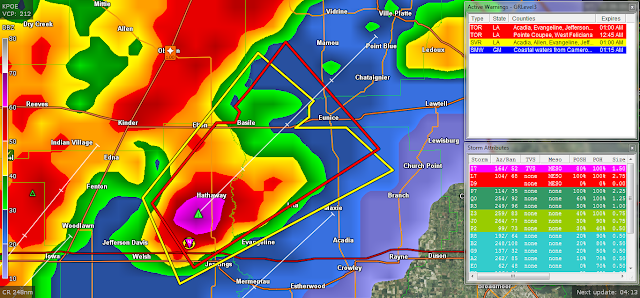


Friday, January 20, 2017

SEVERE THUNDERSTORM WARNING LOUISIANA
420
WUUS54 KLCH 210426
SVRLCH
LAC001-003-039-053-210500-
/O.NEW.KLCH.SV.W.0017.170121T0426Z-170121T0500Z/
BULLETIN - IMMEDIATE BROADCAST REQUESTED
Severe Thunderstorm Warning
National Weather Service Lake Charles LA
1026 PM CST FRI JAN 20 2017
The National Weather Service in Lake Charles has issued a
* Severe Thunderstorm Warning for...
Northeastern Jefferson Davis Parish in southwestern Louisiana...
Southwestern Evangeline Parish in central Louisiana...
Northwestern Acadia Parish in southwestern Louisiana...
Allen Parish in southwestern Louisiana...
* Until 1100 PM CST
* At 1026 PM CST, a severe thunderstorm was located near Kinder,
moving east at 45 mph.
HAZARD...70 mph wind gusts and quarter size hail.
SOURCE...Radar indicated.
IMPACT...Hail damage to vehicles is expected. Expect considerable
tree damage. Wind damage is also likely to mobile homes,
roofs, and outbuildings.
* Locations impacted include...
Eunice, Oakdale, Kinder, Basile, Oberlin, Elton, Mittie, Harmony,
Duralde, Allen Parish Airport, Leblanc, Beaver and Bond.
PRECAUTIONARY/PREPAREDNESS ACTIONS...
For your protection move to an interior room on the lowest floor of a
building.
&&
A tornado watch remains in effect until 200 AM CST for central and
southwestern Louisiana.
LAT...LON 3089 9261 3053 9244 3052 9246 3050 9246
3048 9249 3048 9242 3046 9241 3044 9298
3060 9299 3060 9298 3070 9298
TIME...MOT...LOC 0426Z 250DEG 40KT 3053 9287
HAIL...1.00IN
WIND...70MPH


LOW BAROMETRIC PRESSURE FOR THIS FORECAST LOW PRESSURE SYSTEM
Ryan Maue
@RyanMaue
3 minutes ago


Your barometer in N Georgia and Carolinas may see lowest pressure for non-tropical Low (973 mb) in a generation.


WEST COAST BEING HAMMERED BY A STRONG PACIFIC STORM SYSTEM
STRONG GUSTY WINDS, HEAVY RAINS!
Chula Vista Police @ChulaVistaPD
1 hour ago

Chula Vista Police
Chula Vista Police asks the public to avoid driving tonight. The City is experiencing multiple traffic hazards and power outages

Subscribe to:
Posts (Atom)