I CONTINUE TO SEE THAT ROLLER COASTER SLOPE IN THE MODEL RUN. THAT DOWN SLOPE TOWARDS THE 5 -DAY PERIOD IS MORE THAN LIKELY DUE TO HIGH PRESSURE BUILDING OVER IRMA AND FORCING THE STORM BACK TO THE WEST-SOUTHWEST. THIS IS ALSO DEPICTED IN THE OFFICIAL HURRICANE CENTER FORECAST TRACK. IF THE FORECAST IS CORRECT AND THE SYSTEM CONTINUES TOWARDS THE ISLANDS, THIS COULD BE AN IMPACT TO THE CENTRAL OR NORTHERN LEEWARD ISLANDS.
INTEREST IN THE LESSER ANTILLES SHOULD CLOSELY MONITOR THE PROGRESS OF IRMA.
IRMA CONTINUES TO DEVELOP AND CAN BECOME A HURRICANE AT ANYTIME. IRMA IS FORECAST TO BECOME A MAJOR HURRICANE WITHIN 5-DAYS AND COULD REACH CAT 4 STATUS. THIS STORM SYSTEM NEEDS TO BE WATCHED CLOSELY!
Thursday, August 31, 2017
LATE TROPIC UPDATE 1200 AM EDT 08/31/17
...FLOODING RAINS CONTINUE OVER EXTREME EASTERN TEXAS AND WESTERN
LOUISIANA...
...HEAVY RAINS EXPECTED TO SPREAD NORTHEASTWARD OVER THE MISSISSIPPI
AND TENNESSEE VALLEYS DURING THE NEXT DAY OR TWO...
ZCZC MIATCPAT4 ALL TTAA00 KNHC DDHHMM BULLETIN Tropical Depression Harvey Advisory Number 43 NWS National Hurricane Center Miami FL AL092017 1000 PM CDT Wed Aug 30 2017 ...FLOODING RAINS CONTINUE OVER EXTREME EASTERN TEXAS AND WESTERN LOUISIANA... ...HEAVY RAINS EXPECTED TO SPREAD NORTHEASTWARD OVER THE MISSISSIPPI AND TENNESSEE VALLEYS DURING THE NEXT DAY OR TWO... SUMMARY OF 1000 PM CDT...0300 UTC...INFORMATION ----------------------------------------------- LOCATION...31.7N 92.3W ABOUT 30 MI...50 KM NNE OF ALEXANDRIA LOUISIANA ABOUT 100 MI...160 KM SE OF SHREVEPORT LOUISIANA MAXIMUM SUSTAINED WINDS...35 MPH...55 KM/H PRESENT MOVEMENT...NNE OR 30 DEGREES AT 9 MPH...15 KM/H MINIMUM CENTRAL PRESSURE...998 MB...29.47 INCHES WATCHES AND WARNINGS -------------------- CHANGES WITH THIS ADVISORY: None SUMMARY OF WATCHES AND WARNINGS IN EFFECT: There are no coastal watches or warnings in effect. Catastrophic and life-threatening flooding continues in southeastern Texas and portions of southwestern Louisiana. Please see warnings and other products issued by your local National Weather Service office for additional information on this life-threatening situation. DISCUSSION AND 48-HOUR OUTLOOK ------------------------------ At 1000 PM CDT (0300 UTC), the center of Tropical Depression Harvey was located near latitude 31.7 North, longitude 92.3 West. The depression is moving toward the north-northeast near 9 mph (15 km/h) and this motion is expected to continue tonight. A turn toward the northeast is expected Thursday or Thursday night. On the forecast track, the center of Harvey should move through central Louisiana tonight, then move through northeastern Louisiana and northwestern Mississippi Thursday and Thursday night, and over the Tennessee Valley region on Friday. Maximum sustained winds are near 35 mph (55 km/h) with higher gusts. Gradual weakening is expected over the next 48 hours. The estimated minimum central pressure is 998 mb (29.47 inches). HAZARDS AFFECTING LAND ---------------------- RAINFALL: Harvey is expected to produce additional rainfall accumulations of 4 to 8 inches from southwestern Louisiana and the adjacent border of eastern Texas northeastward into western Tennessee and Kentucky through Friday with isolated amounts up to 12 inches. The threat of heavy rains has ended in the Houston/ Galveston area. However catastrophic and life-threatening flooding will continue in and around Houston, Beaumont/Port Arthur, and eastward into southwest Louisiana for the rest of the week. The expected heavy rains spreading northeastward from Louisiana into western Kentucky may also lead to flash flooding and increased river and small stream flooding. DO NOT ATTEMPT TO TRAVEL IN THE AFFECTED AREA IF YOU ARE IN A SAFE PLACE. DO NOT DRIVE INTO FLOODED ROADWAYS. Please see warnings and products issued by your local National Weather Service office for additional information on this life-threatening situation. Elsewhere, the outer bands of Harvey are expected to produce additional rainfall amounts of 3 to 6 inches over portions of the central and eastern Gulf States and 2 to 4 inches farther north into parts of the Tennessee Valley, Ohio Valley and southern Mid Atlantic through Saturday. These rains may lead to flooding concerns across these areas. A list of preliminary rainfall observations compiled by the NOAA Weather Prediction Center can be found at: www.wpc.ncep.noaa.gov/discussions/nfdscc1.html STORM SURGE: Water levels along the northwestern and northern Gulf coast should subside very slowly over the next day or two. TORNADOES: Isolated tornadoes are possible tonight across parts of Mississippi, southern Alabama, and southwest Georgia. Additional tornadoes are possible on Thursday afternoon and evening across northern portions of Mississippi, Alabama, Georgia, and into parts of Tennessee. NEXT ADVISORY ------------- This is the last public advisory issued by the National Hurricane Center on Harvey. Future information on this system can be found in Public Advisories issued by the Weather Prediction Center beginning at 4 AM CDT, under AWIPS header TCPAT4, WMO header WTNT34 KWNH, and on the web at http://www.wpc.ncep.noaa.gov. These advisories will also continue to be found on the National Hurricane Center website at hurricanes.gov. $$ Forecaster Brown NNNN
...IRMA EXPECTED TO BECOME A HURRICANE ON THURSDAY...
000 WTNT31 KNHC 310231 TCPAT1 BULLETIN Tropical Storm Irma Advisory Number 3 NWS National Hurricane Center Miami FL AL112017 1100 PM AST Wed Aug 30 2017 ...IRMA EXPECTED TO BECOME A HURRICANE ON THURSDAY... SUMMARY OF 1100 PM AST...0300 UTC...INFORMATION ----------------------------------------------- LOCATION...16.4N 32.2W ABOUT 545 MI...875 KM W OF THE CABO VERDE ISLANDS MAXIMUM SUSTAINED WINDS...65 MPH...100 KM/H PRESENT MOVEMENT...W OR 275 DEGREES AT 12 MPH...19 KM/H MINIMUM CENTRAL PRESSURE...999 MB...29.50 INCHES WATCHES AND WARNINGS -------------------- There are no coastal watches or warnings in effect. DISCUSSION AND 48-HOUR OUTLOOK ------------------------------ At 1100 PM AST (0300 UTC), the center of Tropical Storm Irma was located near latitude 16.4 North, longitude 32.2 West. Irma is moving toward the west near 12 mph (19 km/h). A turn toward the west-northwest is expected by Thursday, and this general motion should continue through Friday. Maximum sustained winds have increased to near 65 mph (100 km/h) with higher gusts. Additional strengthening is forecast and Irma is expected to become a hurricane on Thursday. Tropical-storm-force winds extend outward up to 60 miles (95 km) from the center. The estimated minimum central pressure is 999 mb (29.50 inches). HAZARDS AFFECTING LAND ---------------------- None NEXT ADVISORY ------------- Next complete advisory at 500 AM AST. $$ Forecaster Brown
Wednesday, August 30, 2017
HARVEY AND IRMA ADVISORY AND FORECAST MAPS AUG 30, 2017
...HARVEY WEAKENING AS IT MOVES FARTHER INLAND...
...FLOODING RAINS CONTINUING OVER EXTREME SOUTHEASTERN TEXAS AND
SOUTHWESTERN LOUISIANA...
ZCZC MIATCPAT4 ALL TTAA00 KNHC DDHHMM BULLETIN 
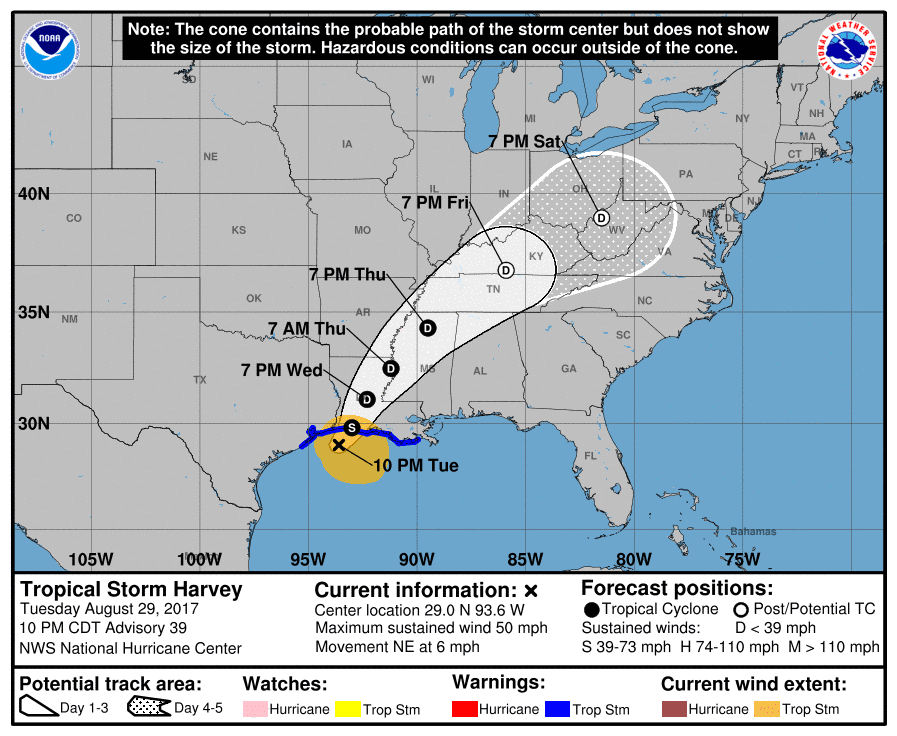
Tropical Storm Harvey Advisory Number 42 NWS National Hurricane Center Miami FL AL092017 400 PM CDT Wed Aug 30 2017 ...HARVEY STILL PRODUCING TROPICAL-STORM-FORCE WINDS NEAR THE LOUISIANA COAST... ...FLOODING RAINS CONTINUING OVER EXTREME EASTERN TEXAS AND WESTERN LOUISIANA... SUMMARY OF 400 PM CDT...2100 UTC...INFORMATION ---------------------------------------------- LOCATION...30.8N 93.1W ABOUT 50 MI...80 KM N OF LAKE CHARLES LOUISIANA ABOUT 50 MI...80 KM SW OF ALEXANDRIA LOUISIANA MAXIMUM SUSTAINED WINDS...40 MPH...65 KM/H PRESENT MOVEMENT...NNE OR 20 DEGREES AT 8 MPH...13 KM/H MINIMUM CENTRAL PRESSURE...998 MB...29.47 INCHES WATCHES AND WARNINGS -------------------- CHANGES WITH THIS ADVISORY: The Storm Surge Watch and Warning are discontinued for the coasts of Texas and Louisiana. SUMMARY OF WATCHES AND WARNINGS IN EFFECT: A Tropical Storm Warning is in effect for... * Sabine Pass Texas to Grand Isle Louisiana Catastrophic and life-threatening flooding continues in southeastern Texas and portions of southwestern Louisiana. Please see warnings and other products issued by your local National Weather Service office for additional information on this life-threatening situation. For storm information specific to your area, including possible inland watches and warnings, please monitor products issued by your local National Weather Service forecast office. DISCUSSION AND 48-HOUR OUTLOOK ------------------------------ At 400 PM CDT (2100 UTC), the center of Tropical Storm Harvey was located near latitude 30.8 North, longitude 93.1 West. Harvey is moving erratically toward the north-northeast near 8 mph (13 km/h) and this motion is expected to continue tonight. A turn toward the northeast is expected Thursday or Thursday night. On the forecast track, the center of Harvey should move through southwestern and central Louisiana tonight, then move through northeastern Louisiana and northwestern Mississippi Thursday and Thursday night. Maximum sustained winds are near 40 mph (65 km/h) with higher gusts. Weakening is forecast during the next 48 hours as Harvey moves farther inland, and the cyclone is expected to weaken to a tropical depression tonight. Tropical-storm-force winds extend outward up to 140 miles (220 km) mainly over water to the southeast of the center. An automated station near Lacassine, Louisiana recently reported a wind gust of 44 mph (71 km/h). The estimated minimum central pressure based on surface observations is 998 mb (29.47 inches). HAZARDS AFFECTING LAND ---------------------- RAINFALL: Harvey is expected to produce additional rainfall accumulations of 4 to 8 inches from southwestern Louisiana and the adjacent border of eastern Texas northeastward into western Tennessee and Kentucky through Friday with isolated amounts up to 12 inches. The threat of heavy rains has ended in the Houston/ Galveston area. However catastrophic and life threatening flooding will continue in and around Houston, Beaumont/Port Arthur, eastward into southwest Louisiana for the rest of the week. The expected heavy rains spreading northeastward from Louisiana into western Kentucky may also lead to flash flooding and increased river and small stream flooding. DO NOT ATTEMPT TO TRAVEL IN THE AFFECTED AREA IF YOU ARE IN A SAFE PLACE. DO NOT DRIVE INTO FLOODED ROADWAYS. Please see warnings and products issued by your local National Weather Service office for additional information on this life-threatening situation. Elsewhere, the outer bands of Harvey are expected to produce additional rainfall amounts of 3 to 6 inches over portions of the central and eastern Gulf States and 2 to 4 inches farther north into parts of the Tennessee Valley, Ohio Valley and southern Mid Atlantic through Saturday. These rains may lead to flooding concerns across these areas. A list of preliminary rainfall observations compiled by the NOAA Weather Prediction Center can be found at: www.wpc.ncep.noaa.gov/discussions/nfdscc1.html STORM SURGE: The combination of a dangerous storm surge and the tide will cause normally dry areas near the coast to be flooded by rising waters moving inland from the shoreline. The water is expected to reach the following heights above ground if the peak surge occurs at the time of high tide... San Luis Pass to Grand Isle...1 to 2 ft The deepest water will occur along the immediate coast near the area of onshore winds. Surge-related flooding depends on the relative timing of the surge and the tidal cycle, and can vary greatly over short distances. For information specific to your area, please see products issued by your local National Weather Service forecast office. WIND: Tropical storm conditions are occurring over portions of the warning area along the coast and are likely to persist through this evening. Gusts to tropical-storm-force are possible over other portions of southern Louisiana through this evening. SURF: Swells generated by Harvey are still affecting the coast of Louisiana, but are expected to subside late tonight and Thursday. These swells are likely to cause life-threatening surf and rip current conditions. Please consult products from your local weather office. TORNADOES: A few tornadoes are possible through this evening across parts of Louisiana, Mississippi, western Alabama, and southeast Arkansas. Additional tornadoes are possible on Thursday afternoon and evening across northern portions of Mississippi, Alabama, and Georgia into parts of Tennessee. NEXT ADVISORY ------------- Next intermediate advisory at 700 PM CDT. Next complete advisory at 1000 PM CDT. $$ Forecaster Beven NNNN
...IRMA FORMS OVER THE FAR EASTERN ATLANTIC... ...NO IMMEDIATE THREAT TO LAND...
ZCZC MIATCPAT1 ALL TTAA00 KNHC DDHHMM BULLETIN Tropical Storm Irma Advisory Number 2 NWS National Hurricane Center Miami FL AL112017 500 PM AST Wed Aug 30 2017 ...IRMA INTENSIFYING STEADILY OVER THE FAR EASTERN ATLANTIC... SUMMARY OF 500 PM AST...2100 UTC...INFORMATION ---------------------------------------------- LOCATION...16.4N 31.2W ABOUT 480 MI...770 KM W OF THE CABO VERDE ISLANDS MAXIMUM SUSTAINED WINDS...60 MPH...95 KM/H PRESENT MOVEMENT...W OR 275 DEGREES AT 15 MPH...24 KM/H MINIMUM CENTRAL PRESSURE...1001 MB...29.56 INCHES WATCHES AND WARNINGS -------------------- There are no coastal watches or warnings in effect. DISCUSSION AND 48-HOUR OUTLOOK ------------------------------ At 500 PM AST (2100 UTC), the center of Tropical Storm Irma was located near latitude 16.4 North, longitude 31.2 West. Irma is moving toward the west near 15 mph (24 km/h). The tropical storm is expected to turn slightly toward the west-northwest at a slower rate of speed for the next couple of days. Maximum sustained winds are near 60 mph (95 km/h) with higher gusts. Some strengthening is forecast during the next 48 hours and Irma is expected to become a hurricane Thursday or Friday. Tropical-storm-force winds extend outward up to 35 miles (55 km) from the center. The estimated minimum central pressure is 1001 mb (29.56 inches). HAZARDS AFFECTING LAND ---------------------- None NEXT ADVISORY ------------- Next complete advisory at 1100 PM AST. $$ Forecaster Landsea NNNN
18z MODEL GUIDANCE AND INTENSITY MODEL RUN FOR HARVEY AND IRMA 0355 PM EDT AUG 30 2017
HARVEY 18z MODEL RUN
The 18z model run for IRMA no telling where it will go at this time. Some suggest East of the U.S. Coast other suggest somewhere along the Eastern Sea board or in the Gulf of Mexico. There to many uncertainties at this time. Monday will have a better feel of where it may end up. Will continue to watch closely. http://ralphstropicalweather.myfreesites.net
Satellite shows a maturing tropical cyclone and we could see a hurricane form over night or tomorrow. Wind shear for the next five days looks good for development. In this image animation you can see the buzz saw look which means this system has good over all inflow and outflow. IRMA a storm to watch.
The 18z Intensity model from tropicaltidbits.com show a Category 3 hurricane in the near future. I think it could get up higher depending on the conditions ahead next week. RTW
HARVEY AND IRMA FORECAST ADVISORY 1100 AM EDT AUG 30 1017
000 WTNT34 KNHC 301447 TCPAT4 BULLETIN Tropical Storm Harvey Advisory Number 41 NWS National Hurricane Center Miami FL AL092017 1000 AM CDT Wed Aug 30 2017 ...CENTER OF HARVEY MOVING FARTHER INLAND OVER SOUTHWESTERN LOUISIANA... ...FLOODING RAINS CONTINUING OVER EXTREME SOUTHEASTERN TEXAS AND SOUTHWESTERN LOUISIANA... SUMMARY OF 1000 AM CDT...1500 UTC...INFORMATION ----------------------------------------------- LOCATION...30.5N 93.3W ABOUT 30 MI...45 KM NNW OF LAKE CHARLES LOUISIANA ABOUT 75 MI...115 KM SW OF ALEXANDRIA LOUISIANA MAXIMUM SUSTAINED WINDS...45 MPH...75 KM/H PRESENT MOVEMENT...NNE OR 20 DEGREES AT 8 MPH...13 KM/H MINIMUM CENTRAL PRESSURE...993 MB...29.33 INCHES WATCHES AND WARNINGS -------------------- CHANGES WITH THIS ADVISORY: The Storm Surge Watch is discontinued west of Sabine Pass, Texas. SUMMARY OF WATCHES AND WARNINGS IN EFFECT: A Storm Surge Warning is in effect for... * Holly Beach Louisiana to Morgan City Louisiana A Storm Surge Watch is in effect for... * Sabine Pass Texas to west of Holly Beach Louisiana A Tropical Storm Warning is in effect for... * East of High Island Texas to Grand Isle Louisiana Catastrophic and life-threatening flooding continues in southeastern Texas and portions of southwestern Louisiana. Please see warnings and other products issued by your local National Weather Service office for additional information on this life-threatening situation. A Storm Surge Warning means there is a danger of life-threatening inundation, from rising water moving inland from the coastline, during the next 12 hours in the indicated locations. For a depiction of areas at risk, please see the National Weather Service Storm Surge Watch/Warning Graphic, available at hurricanes.gov. This is a life-threatening situation. Persons located within these areas should take all necessary actions to protect life and property from rising water and the potential for other dangerous conditions. Promptly follow evacuation and other instructions from local officials. For storm information specific to your area, including possible inland watches and warnings, please monitor products issued by your local National Weather Service forecast office. DISCUSSION AND 48-HOUR OUTLOOK ------------------------------ At 1000 AM CDT (1500 UTC), the center of Tropical Storm Harvey was located near latitude 30.5 North, longitude 93.3 West. Harvey is moving toward the north-northeast near 8 mph (13 km/h) and this general motion is expected to continue through Thursday. A turn toward the northeast is expected Thursday night and Friday. On the forecast track, the center of Harvey should move through southwestern and central Louisiana today and tonight, then move through northeastern Louisiana and northwestern Mississippi Thursday and Thursday night. Maximum sustained winds are near 45 mph (75 km/h) with higher gusts. Weakening is forecast during the next 48 hours as Harvey moves farther inland, and the cyclone is expected to weaken to a tropical depression tonight. Tropical-storm-force winds extend outward up to 80 miles (130 km) mainly to the south of the center. During the past few hours, there have been reports of wind gusts of 40-50 mph (65-80 km/h) in southwestern Louisiana and southeastern Texas near Lake Charles, Cameron, and Sabine Pass. The minimum central pressure based on surface observations is 993 mb (29.33 inches). HAZARDS AFFECTING LAND ---------------------- RAINFALL: Harvey is expected to produce additional rainfall accumulations of 3 to 6 inches from southwestern Louisiana and the adjacent border of eastern Texas northeastward into western Tennessee and Kentucky through Friday with isolated amounts up to 10 inches. The threat of heavy rains has ended in the Houston/ Galveston area. However catastrophic and life threatening flooding will continue in and around Houston, Beaumont/Port Arthur, eastward into southwest Louisiana for the rest of the week. The expected heavy rains spreading northeastward from Louisiana into western Kentucky may also lead to flash flooding and increased river, small stream flooding. DO NOT ATTEMPT TO TRAVEL IN THE AFFECTED AREA IF YOU ARE IN A SAFE PLACE. DO NOT DRIVE INTO FLOODED ROADWAYS. Please see warnings and products issued by your local National Weather Service office for additional information on this life-threatening situation. Elsewhere, the outer bands of Harvey are expected to produce additional rainfall amounts of 3 to 6 inches over portions of the central and eastern Gulf States and 2 to 4 inches farther north into parts of the Tennessee Valley, Ohio Valley and southern Mid Atlantic through Saturday. These rains may lead to flooding concerns across these areas. A list of preliminary rainfall observations compiled by the NOAA Weather Prediction Center can be found at: www.wpc.ncep.noaa.gov/discussions/nfdscc1.html STORM SURGE: The combination of a dangerous storm surge and the tide will cause normally dry areas near the coast to be flooded by rising waters moving inland from the shoreline. The water is expected to reach the following heights above ground if the peak surge occurs at the time of high tide... Holly Beach to Morgan City...2 to 4 ft San Luis Pass to west of Holly Beach incl. Galveston Bay...1 to 3 ft Morgan City to Grand Isle...1 to 3 ft The deepest water will occur along the immediate coast near the area of onshore winds. Surge-related flooding depends on the relative timing of the surge and the tidal cycle, and can vary greatly over short distances. For information specific to your area, please see products issued by your local National Weather Service forecast office. WIND: Tropical storm conditions are occurring over portions of the warning area along the coast and are likely to persist through this afternoon. SURF: Swells generated by Harvey are still affecting the coasts of Texas and Louisiana. These swells are likely to cause life- threatening surf and rip current conditions. Please consult products from your local weather office. TORNADOES: A few tornadoes are possible today and tonight over parts of Louisiana, Mississippi, southern Alabama, and southeast Arkansas. NEXT ADVISORY ------------- Next intermediate advisory at 100 PM CDT. Next complete advisory at 400 PM CDT. $$ Forecaster Beven
...IRMA FORMS OVER THE FAR EASTERN ATLANTIC...
...NO IMMEDIATE THREAT TO LAND...
ZCZC MIATCPAT1 ALL TTAA00 KNHC DDHHMM BULLETIN Tropical Storm Irma Advisory Number 1 NWS National Hurricane Center Miami FL AL112017 1100 AM AST Wed Aug 30 2017 ...IRMA FORMS OVER THE FAR EASTERN ATLANTIC... ...NO IMMEDIATE THREAT TO LAND... SUMMARY OF 1100 AM AST...1500 UTC...INFORMATION ----------------------------------------------- LOCATION...16.4N 30.3W ABOUT 420 MI...675 KM W OF THE CABO VERDE ISLANDS MAXIMUM SUSTAINED WINDS...50 MPH...85 KM/H PRESENT MOVEMENT...W OR 280 DEGREES AT 13 MPH...20 KM/H MINIMUM CENTRAL PRESSURE...1004 MB...29.65 INCHES WATCHES AND WARNINGS -------------------- There are no coastal watches or warnings in effect. DISCUSSION AND 48-HOUR OUTLOOK ------------------------------ At 1100 AM AST (1500 UTC), the center of Tropical Storm Irma was located near latitude 16.4 North, longitude 30.3 West. Irma is moving toward the west near 13 mph (20 km/h) and this general motion is expected to continue for the next couple of days. Satellite wind data indicate that the maximum sustained winds are near 50 mph (85 km/h) with higher gusts. Some strengthening is forecast during the next 48 hours and Irma could become a hurricane on Friday. Tropical-storm-force winds extend outward up to 35 miles (55 km) from the center. The estimated minimum central pressure is 1004 mb (29.65 inches). HAZARDS AFFECTING LAND ---------------------- None NEXT ADVISORY ------------- Next complete advisory at 500 PM AST. $$ Forecaster Blake NNNN
12z MODEL RUN FOR HARVEY AND NEWLY FORM TROPICAL STORM IRMA 1031 AM EDT AUG 30, 2017
HARVEY INLAND OVER LOUISIANA DUMPING MORE RAINS OVER THAT STATE.
NEWLY FORMED TROPICAL STORM IRMA WEST OF THE CABO VERDE OR (CAPE VERDE ISLANDS), NHC WILL BEGIN ISSUING ADVISORY ON THIS SYSTEM AT 11 AM EDT AUG 30, 2017.
IRMA COULD BE THE NEXT MAJOR HURRICANE IN THE ATLANTIC AS IT PASSES NORTH OF THE NORTHERN LEEWARD ISLANDS SOMETIME NEXT WEEK.
SOME PREVIOUS MODELS RE-CURVE THIS STORM SYSTEM NORTH AND AWAY FROM THE EASTERN SEA BOARD, BUT ITS STILL TO EARLY TO KNOW THE ACTUAL TRACK IT WILL TAKE. STAY TUNED HERE FOR UPDATES.
Tuesday, August 29, 2017
STORM INVESTIGATION 93L 1139 PM EDT AUG 29, 2017
MONITORING INVEST 93L THAT HAS HIGH CHANCE FOR DEVELOPMENT. THIS COULD BECOME A TROPICAL DEPRESSION OR STORM AT ANYTIME. MOST OF THE MODEL KEEP THIS SYSTEM ON A WEST TO WEST-NORTHWEST TRACK. SO EYES ON THIS ONE INTO NEXT WEEK.
HARVEY UPDATE 1100 PM EDT AUG 29, 2017
...HARVEY STILL PRODUCING HEAVY RAINS OVER FAR EAST TEXAS AND
SOUTHWESTERN LOUISIANA...
000 WTNT34 KNHC 300253 TCPAT4 BULLETIN Tropical Storm Harvey Advisory Number 39 NWS National Hurricane Center Miami FL AL092017 1000 PM CDT Tue Aug 29 2017 ...HARVEY STILL PRODUCING HEAVY RAINS OVER FAR EAST TEXAS AND SOUTHWESTERN LOUISIANA... SUMMARY OF 1000 PM CDT...0300 UTC...INFORMATION ----------------------------------------------- LOCATION...29.0N 93.6W ABOUT 60 MI...95 KM SSW OF CAMERON LOUISIANA ABOUT 65 MI...105 KM SSE OF PORT ARTHUR TEXAS MAXIMUM SUSTAINED WINDS...50 MPH...85 KM/H PRESENT MOVEMENT...NE OR 35 DEGREES AT 6 MPH...9 KM/H MINIMUM CENTRAL PRESSURE...994 MB...29.36 INCHES WATCHES AND WARNINGS -------------------- CHANGES WITH THIS ADVISORY: The Tropical Storm Warning along the coast of Louisiana has been extended eastward to Grand Isle. The Tropical Storm Warning along the coast of Texas has been discontinued to the south of Freeport. SUMMARY OF WATCHES AND WARNINGS IN EFFECT: A Storm Surge Warning is in effect for... * Holly Beach to Morgan City A Storm Surge Watch is in effect for... * Port Bolivar to west of Holly Beach A Tropical Storm Warning is in effect for... * North of Freeport Texas to Grand Isle Louisiana Catastrophic and life-threatening flooding continues in southeastern Texas and portions of southwestern Louisiana. Please see warnings and other products issued by your local National Weather Service office for additional information on this life-threatening situation. A Storm Surge Warning means there is a danger of life-threatening inundation, from rising water moving inland from the coastline, during the next 12 to 24 hours in the indicated locations. For a depiction of areas at risk, please see the National Weather Service Storm Surge Watch/Warning Graphic, available at hurricanes.gov. This is a life-threatening situation. Persons located within these areas should take all necessary actions to protect life and property from rising water and the potential for other dangerous conditions. Promptly follow evacuation and other instructions from local officials. For storm information specific to your area, including possible inland watches and warnings, please monitor products issued by your local National Weather Service forecast office. DISCUSSION AND 48-HOUR OUTLOOK ------------------------------ At 1000 PM CDT (0300 UTC), the center of Tropical Storm Harvey was located near latitude 29.0 North, longitude 93.6 West. Harvey is moving toward the northeast near 6 mph (9 km/h). A north- northeastward motion is expected later tonight and this general motion should continue through Wednesday night. On the forecast track, the center of Harvey is expected to move inland over the northwestern Gulf Coast within the tropical storm warning area early Wednesday. Maximum sustained winds are near 50 mph (85 km/h) with higher gusts. No significant change in strength is anticipated before the center crosses the coast, but gradual weakening should begin thereafter. Tropical-storm-force winds extend outward up to 160 miles (260 km) from the center. The estimated minimum central pressure is 994 mb (29.36 inches). HAZARDS AFFECTING LAND ---------------------- RAINFALL: Harvey is expected to produce additional rainfall accumulations of 6 to 12 inches to the north and east of Houston from far east Texas into southwestern Louisiana. Isolated storm totals will reach 50 inches over the upper Texas coast, including the Houston/Galveston metropolitan area. These rains are currently producing catastrophic and life-threatening flooding over large portions of southeastern Texas and southwestern Louisiana. DO NOT ATTEMPT TO TRAVEL IN THE AFFECTED AREA IF YOU ARE IN A SAFE PLACE. DO NOT DRIVE INTO FLOODED ROADWAYS. Please see warnings and products issued by your local National Weather Service office for additional information on this life-threatening situation. Elsewhere, Harvey is expected to produce total rainfall amounts of 5 to 10 inches across portions of southern Louisiana into coastal Mississippi and Alabama. Rainfall associated with Harvey will spread north by mid to late week, with rainfall amounts of 4 to 8 inches spreading into portions of Arkansas and the Tennessee Valley. A preliminary report from a rain gauge has broken the Texas tropical cyclone rainfall record. The Cedar Bayou gauge, east of Highlands, Texas, has reported 51.88 inches of rain as of 3 PM CDT. This total is higher than the previous record of 48 inches set during tropical cyclone Amelia of 1978 at Medina, Texas. A list of rainfall observations compiled by the NOAA Weather Prediction Center can be found at: www.wpc.ncep.noaa.gov/discussions/nfdscc1.html STORM SURGE: The combination of a dangerous storm surge and the tide will cause normally dry areas near the coast to be flooded by rising waters moving inland from the shoreline. The water is expected to reach the following heights above ground if the peak surge occurs at the time of high tide... Holly Beach to Morgan City...2 to 4 ft San Luis Pass to west of Holly Beach including Galveston Bay...1 to 3 ft Morgan City to Grand Isle...1 to 2 ft The deepest water will occur along the immediate coast near the area of onshore winds. Surge-related flooding depends on the relative timing of the surge and the tidal cycle, and can vary greatly over short distances. For information specific to your area, please see products issued by your local National Weather Service forecast office. WIND: Tropical storm conditions are occurring over portions of the warning area along the coast and are likely to persist through Wednesday. SURF: Swells generated by Harvey are still affecting the coasts of Texas and Louisiana. These swells are likely to cause life-threatening surf and rip current conditions. Please consult products from your local weather office. TORNADOES: A few tornadoes are possible through Wednesday across parts of Louisiana, Mississippi, southern Alabama, and southeast Arkansas. NEXT ADVISORY ------------- Next intermediate advisory at 100 AM CDT. Next complete advisory at 400 AM CDT. $$ Forecaster Brown
HARVEY AND TROPICAL DEPRESSION TEN UPDATE 0514 PM EDT AUG 29, 2017
...HARVEY CRAWLING TOWARD THE COAST DUMPING CATASTROPHIC RAINS OVER SOUTHEASTERN TEXAS AND SOUTHWESTERN LOUISIANA...
000 WTNT34 KNHC 292039 TCPAT4 BULLETIN Tropical Storm Harvey Advisory Number 38 NWS National Hurricane Center Miami FL AL092017 400 PM CDT Tue Aug 29 2017 ...HARVEY CRAWLING TOWARD THE COAST DUMPING CATASTROPHIC RAINS OVER SOUTHEASTERN TEXAS AND SOUTHWESTERN LOUISIANA... SUMMARY OF 400 PM CDT...2100 UTC...INFORMATION ---------------------------------------------- LOCATION...29.2N 94.3W ABOUT 55 MI...85 KM SSW OF PORT ARTHUR TEXAS ABOUT 75 MI...115 KM SW OF CAMERON LOUISIANA MAXIMUM SUSTAINED WINDS...50 MPH...85 KM/H PRESENT MOVEMENT...NNE OR 30 DEGREES AT 6 MPH...9 KM/H MINIMUM CENTRAL PRESSURE...994 MB...29.36 INCHES WATCHES AND WARNINGS -------------------- CHANGES WITH THIS ADVISORY: A Storm Surge Warning has been issued from Holly Beach to Morgan City Louisiana. SUMMARY OF WATCHES AND WARNINGS IN EFFECT: A Storm Surge Warning is in effect for... * Holly Beach to Morgan City A Storm Surge Watch is in effect for... * Port Bolivar to west of Holly Beach A Tropical Storm Warning is in effect for... * North of Port O'Connor to Morgan City Louisiana A Tropical Storm Watch is in effect for... * East of Morgan City to Grand Isle Catastrophic and life-threatening flooding continues in southeastern Texas and portions of southwestern Louisiana. Please see warnings and other products issued by your local National Weather Service office for additional information on this life-threatening situation. A Storm Surge Warning means there is a danger of life-threatening inundation, from rising water moving inland from the coastline, during the next 12 to 24 hours in the indicated locations. For a depiction of areas at risk, please see the National Weather Service Storm Surge Watch/Warning Graphic, available at hurricanes.gov. This is a life-threatening situation. Persons located within these areas should take all necessary actions to protect life and property from rising water and the potential for other dangerous conditions. Promptly follow evacuation and other instructions from local officials. For storm information specific to your area, including possible inland watches and warnings, please monitor products issued by your local National Weather Service forecast office. DISCUSSION AND 48-HOUR OUTLOOK ------------------------------ At 400 PM CDT (2100 UTC), the center of Tropical Storm Harvey was estimated from data from an Air Force reconnaissance plane near latitude 29.2 North, longitude 94.3 West. Harvey is moving toward the north-northeast near 6 mph (9 km/h), and this general motion is expected to continue tonight and tomorrow. On the forecast track, the broad circulation center of Harvey is expected to move inland over the northwestern Gulf Coast within the tropical storm warning area by early Wednesday. Maximum sustained winds are near 50 mph (85 km/h) with higher gusts. No significant change in strength is anticipated before the center crosses the coast, but gradual weakening should begin thereafter. Tropical-storm-force winds extend outward up to 160 miles (260 km) from the center. Galveston recently reported a sustained wind of 39 mph and a gust to 54 mph. The minimum central pressure reported by an Air Force reconnaissance plane was 994 mb (29.36 inches). HAZARDS AFFECTING LAND ---------------------- RAINFALL: Harvey is expected to produce additional rainfall accumulations of 6 to 12 inches to the north and east of Houston from far east Texas into southwestern Louisiana. Isolated storm totals will reach 50 inches over the upper Texas coast, including the Houston/Galveston metropolitan area. These rains are currently producing catastrophic and life-threatening flooding over large portions of southeastern Texas and southwestern Louisiana. DO NOT ATTEMPT TO TRAVEL IN THE AFFECTED AREA IF YOU ARE IN A SAFE PLACE. DO NOT DRIVE INTO FLOODED ROADWAYS. Please see warnings and products issued by your local National Weather Service office for additional information on this life-threatening situation. Elsewhere, Harvey is expected to produce total rainfall amounts of 5 to 10 inches across portions of southern Louisiana into coastal Mississippi and Alabama. Rainfall associated with Harvey will spread north by mid to late week, with rainfall amounts of 4 to 8 inches spreading into portions of Arkansas and the Tennessee Valley. A preliminary report from a rain gauge has broken the Texas tropical cyclone rainfall record. The Cedar Bayou gauge, east of Highlands, Texas, has reported 51.88 inches of rain as of 3 PM CDT. This total is higher than the previous record of 48 inches set during tropical cyclone Amelia of 1978 at Medina, Texas. A list of rainfall observations compiled by the NOAA Weather Prediction Center can be found at: www.wpc.ncep.noaa.gov/discussions/nfdscc1.html STORM SURGE: The combination of a dangerous storm surge and the tide will cause normally dry areas near the coast to be flooded by rising waters moving inland from the shoreline. The water is expected to reach the following heights above ground if the peak surge occurs at the time of high tide... Holly Beach to Morgan City...2 to 4 ft San Luis Pass to west of Holly Beach including Galveston Bay...1 to 3 ft The deepest water will occur along the immediate coast near the area of onshore winds. Surge-related flooding depends on the relative timing of the surge and the tidal cycle, and can vary greatly over short distances. For information specific to your area, please see products issued by your local National Weather Service forecast office. WIND: Tropical storm conditions are occurring over portions of the warning area along the coast and are likely to persist during the next day or so. Tropical storms conditions are possible within the watch area within the next 24 hours. SURF: Swells generated by Harvey are still affecting the coasts of Texas and Louisiana. These swells are likely to cause life-threatening surf and rip current conditions. Please consult products from your local weather office. TORNADOES: A few tornadoes are possible today from extreme southeast Texas across parts of southern Louisiana, coastal Mississippi and coastal Alabama. NEXT ADVISORY ------------- Next intermediate advisory at 700 PM CDT. Next complete advisory at 1000 PM CDT. $$ Forecaster Avila
000 WTNT35 KNHC 292031 TCPAT5 BULLETIN Potential Tropical Cyclone Ten Advisory Number 9 NWS National Hurricane Center Miami FL AL102017 500 PM EDT Tue Aug 29 2017 ...DISTURBANCE MOVING AWAY FROM THE NORTH CAROLINA COAST... ...THIS IS THE LAST ADVISORY... SUMMARY OF 500 PM EDT...2100 UTC...INFORMATION ---------------------------------------------- LOCATION...36.0N 74.3W ABOUT 85 MI...140 KM NE OF CAPE HATTERAS NORTH CAROLINA MAXIMUM SUSTAINED WINDS...45 MPH...75 KM/H PRESENT MOVEMENT...NE OR 50 DEGREES AT 24 MPH...39 KM/H MINIMUM CENTRAL PRESSURE...1003 MB...29.62 INCHES WATCHES AND WARNINGS -------------------- CHANGES WITH THIS ADVISORY: All tropical storm warnings for the coast of North Carolina have been discontinued. SUMMARY OF WATCHES AND WARNINGS IN EFFECT: There are no coastal tropical watches or warnings in effect. High wind warnings are in effect for coastal portions of northeastern North Carolina, southeastern Virginia, and the eastern shore of Virginia and Maryland through this evening. For storm information specific to your area, including possible inland watches and warnings, please monitor products issued by your local National Weather Service forecast office. DISCUSSION AND 48-HOUR OUTLOOK ------------------------------ At 500 PM EDT (2100 UTC), the disturbance was centered off the coast of North Carolina near latitude 36.0 North, longitude 74.3 West. The system is moving toward the northeast near 20 mph (31 km/h), and it is expected to accelerate further toward the northeast and east-northeast during the next couple of days. The disturbance will continue to move away from the North Carolina coast over the western Atlantic Ocean tonight. Maximum sustained winds are near 45 mph (75 km/h) with higher gusts. The disturbance is forecast to strengthen at sea and become a hurricane-force extratropical low over the northwestern Atlantic Ocean by Wednesday evening. The system is not expected to become a tropical cyclone. * Formation chance through 48 hours...low...near 0 percent * Formation chance through 5 days...low...near 0 percent Tropical-storm-force winds extend outward up to 105 miles (165 km) to the east of the center. The estimated minimum central pressure is 1003 mb (29.62 inches). HAZARDS AFFECTING LAND ---------------------- WIND: Strong winds, with gusts up to 55 mph, are expected across coastal portions of northeastern North Carolina, southeastern Virginia, and the eastern shore of Virginia and Maryland through this evening. RAINFALL: The system is expected to produce total rain accumulations of 1 to 3 inches from the southeast Virginia coast into the Delmarva through Wednesday. The heavier rains may result in some flooding concerns along coastal areas. SURF: Swells generated by this disturbance will affect portions of the North Carolina and Virginia coasts during the next day or so, creating dangerous surf and rip current conditions. Please consult products from your local weather office. NEXT ADVISORY ------------- This is the last public advisory issued by the National Hurricane Center on this system. Additional information on this system can be found in High Seas Forecasts issued by the National Weather Service, under AWIPS header NFDHSFAT1, WMO header FZNT01 KWBC, and available on the Web at http://www.opc.ncep.noaa.gov/shtml/NFDHSFAT1.shtml. $$ Forecaster Berg
Subscribe to:
Posts (Atom)