Friday, September 15, 2017
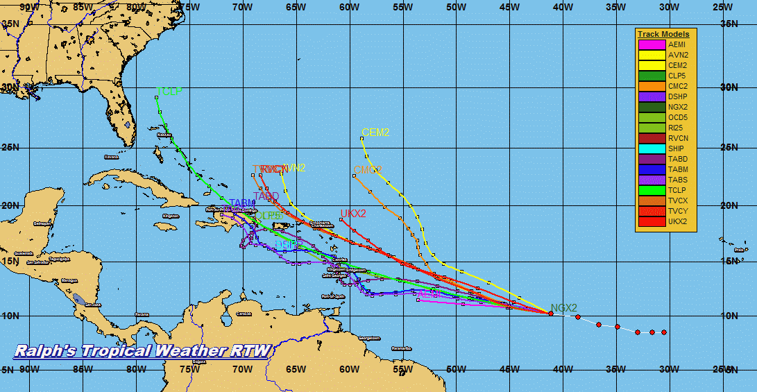
12z MODEL RUN FOR 96L IN THE CENTRAL ATLANTIC.
I BELIEVE THAT JOSE WILL LEAVE A WEAKNESS IN THE HIGH PRESSURE FOR THIS SYSTEM TO FOLLOW BEHIND JOSE. LETS HOPE I AM CORRECT.
JOSE AND TROPICAL DEPRESSION 14 UPDATE 11PM EDT 9/15/17


000
WTNT32 KNHC 151452
TCPAT2

BULLETIN
Tropical Storm Jose Advisory Number  41
NWS National Hurricane Center Miami FL       AL122017
1100 AM AST Fri Sep 15 2017

...AN AIR FORCE PLANE IS EN ROUTE TO DETERMINE IF JOSE IS A
HURRICANE AGAIN...


SUMMARY OF 1100 AM AST...1500 UTC...INFORMATION
-----------------------------------------------
LOCATION...26.5N 69.4W
ABOUT 360 MI...575 KM NE OF THE SOUTHEASTERN BAHAMAS
ABOUT 485 MI...785 KM SW OF BERMUDA
MAXIMUM SUSTAINED WINDS...70 MPH...110 KM/H
PRESENT MOVEMENT...NW OR 305 DEGREES AT 9 MPH...15 KM/H
MINIMUM CENTRAL PRESSURE...989 MB...29.21 INCHES


WATCHES AND WARNINGS
--------------------
There are no coastal watches or warnings in effect.

Interests from North Carolina northward to New England on the east
coast of the United States should monitor the progress of this
system.


DISCUSSION AND 48-HOUR OUTLOOK
------------------------------
At 1100 AM AST (1500 UTC), the center of Tropical Storm Jose was
located near latitude 26.5 North, longitude 69.4 West. Jose is
moving toward the northwest near 9 mph (15 km/h).  This general
motion is expected today, follow by a turn to the north-northwest
by late Saturday and toward the north on Sunday.

Maximum sustained winds remain near 70 mph (110 km/h) with higher
gusts.  Some strengthening is forecast during the next 48 hours. An
Force Reserve Hurricane Hunter aircraft is currently en route to
obtain a better wind speed estimate.

Tropical-storm-force winds extend outward up to 140 miles (220 km)
from the center.

The estimated minimum central pressure is 989 mb (29.21 inches).


HAZARDS AFFECTING LAND
----------------------
SURF:  Swells generated by Jose are affecting Bermuda, the Bahamas,
the northern coasts of Hispaniola and Puerto Rico, and the southeast
coast of the United States, and will spread northward along the
Mid-Atlantic coast of the U.S. during the next few days.  These
swells are likely to cause life-threatening surf and rip current
conditions.  For more information, please consult products from your
local weather office.


NEXT ADVISORY
-------------
Next complete advisory at 500 PM AST.

$$
Forecaster Blake


000
WTNT34 KNHC 151433
TCPAT4

BULLETIN
Tropical Depression Fourteen Advisory Number   3
NWS National Hurricane Center Miami FL       AL142017
1100 AM AST Fri Sep 15 2017

...DEPRESSION FORECAST TO BECOME A TROPICAL STORM LATER TODAY...


SUMMARY OF 1100 AM AST...1500 UTC...INFORMATION
-----------------------------------------------
LOCATION...11.4N 28.3W
ABOUT 430 MI...690 KM SW OF THE CABO VERDE ISLANDS
MAXIMUM SUSTAINED WINDS...35 MPH...55 KM/H
PRESENT MOVEMENT...WNW OR 285 DEGREES AT 10 MPH...17 KM/H
MINIMUM CENTRAL PRESSURE...1008 MB...29.77 INCHES


WATCHES AND WARNINGS
--------------------
There are no coastal watches or warnings in effect.


DISCUSSION AND 48-HOUR OUTLOOK
------------------------------
At 1100 AM AST (1500 UTC), the center of Tropical Depression
Fourteen was located near latitude 11.4 North, longitude 28.3 West.
The depression is moving toward the west-northwest near 10 mph (17
km/h), and a west or west-northwest motion is forecast during the
next couple of days.

Maximum sustained winds are near 35 mph (55 km/h) with higher gusts.
The depression is forecast to become a tropical storm later today.

The estimated minimum central pressure is 1008 mb (29.77 inches).


HAZARDS AFFECTING LAND
----------------------
None


NEXT ADVISORY
-------------
Next complete advisory at 500 PM AST.

$$
Forecaster Blake


Thursday, September 14, 2017
JOSE AND TROPICAL DEPRESSION 14 UPDATE 11 PM EDT SEPT 14, 2017

ZCZC MIATCPAT2 ALL
TTAA00 KNHC DDHHMM

BULLETIN
Tropical Storm Jose Advisory Number  39
NWS National Hurricane Center Miami FL       AL122017
1100 PM AST Thu Sep 14 2017

...JOSE STILL A TROPICAL STORM BUT EXPECTED TO STRENGTHEN...
...LIFE-THREATENING RIP CURRENTS POSSIBLE ALONG PORTIONS OF THE
U.S. EAST COAST...


SUMMARY OF 1100 PM AST...0300 UTC...INFORMATION
-----------------------------------------------
LOCATION...25.5N 68.0W
ABOUT 375 MI...605 KM NE OF THE SOUTHEASTERN BAHAMAS
ABOUT 510 MI...815 KM SSW OF BERMUDA
MAXIMUM SUSTAINED WINDS...70 MPH...110 KM/H
PRESENT MOVEMENT...WNW OR 285 DEGREES AT 8 MPH...13 KM/H
MINIMUM CENTRAL PRESSURE...989 MB...29.21 INCHES


WATCHES AND WARNINGS
--------------------
There are no coastal watches or warnings in effect.

Interests from North Carolina northward to New England on the east
coast of the United States should monitor the progress of this
system.


DISCUSSION AND 48-HOUR OUTLOOK
------------------------------
At 1100 PM AST (0300 UTC), the center of Tropical Storm Jose was
located near latitude 25.5 North, longitude 68.0 West. Jose is
moving toward the west-northwest near 8 mph (13 km/h).  A gradual
turn toward the north is expected during the next two days.

Maximum sustained winds are near 70 mph (110 km/h) with higher
gusts.  Some strengthening is forecast during the next 48 hours,
and Jose is expected to regain hurricane status on Friday.

Tropical-storm-force winds extend outward up to 140 miles (220 km)
from the center.

The estimated minimum central pressure is 989 mb (29.21 inches).


HAZARDS AFFECTING LAND
----------------------
SURF:  Swells generated by Jose are affecting Bermuda, the Bahamas,
the northern coasts of Hispaniola and Puerto Rico, and the Southeast
coast of the United States, and will spread northward along the
Mid-Atlantic coast of the U.S. during the next few days.  These
swells are likely to cause life-threatening surf and rip current
conditions.  For more information, please consult products from your
local weather office.


NEXT ADVISORY
-------------
Next complete advisory at 500 AM AST.

$$
Forecaster Zelinsky


...TROPICAL DEPRESSION FORMS OVER THE EASTERN ATLANTIC...
ZCZC MIATCPAT4 ALL
TTAA00 KNHC DDHHMM

BULLETIN
Tropical Depression Fourteen Advisory Number   1
NWS National Hurricane Center Miami FL       AL142017
1100 PM AST Thu Sep 14 2017

...TROPICAL DEPRESSION FORMS OVER THE EASTERN ATLANTIC...


SUMMARY OF 1100 PM AST...0300 UTC...INFORMATION
-----------------------------------------------
LOCATION...10.7N 25.4W
ABOUT 380 MI...610 KM SSW OF THE CABO VERDE ISLANDS
MAXIMUM SUSTAINED WINDS...35 MPH...55 KM/H
PRESENT MOVEMENT...WNW OR 285 DEGREES AT 22 MPH...35 KM/H
MINIMUM CENTRAL PRESSURE...1010 MB...29.83 INCHES


WATCHES AND WARNINGS
--------------------
There are no coastal watches or warnings in effect.


DISCUSSION AND 48-HOUR OUTLOOK
------------------------------
At 1100 PM AST (0300 UTC), the center of Tropical Depression
Fourteen was located near latitude 10.7 North, longitude 25.4 West.
The depression is moving toward the west-northwest near 22 mph (35
km/h).  A slower westward motion is forecast to begin on Friday and
continue through Saturday.

Maximum sustained winds are near 35 mph (55 km/h) with higher gusts.
Strengthening is expected during the next couple of days, and the
depression is forecast to become a tropical storm later tonight or
Friday.

The estimated minimum central pressure is 1010 mb (29.83 inches).


HAZARDS AFFECTING LAND
----------------------
None


NEXT ADVISORY
-------------
Next complete advisory at 500 AM AST.

$$
Forecaster Brown


TROPICAL STORM JOSE AND INVEST 97L 00z MODEL RUN 1023 PM EDT 9/14/17

JOSE TRACK COMES REAL CLOSE TO THE NORTHEAST AND CANNOT BE DISREGARDED. THOSE WHO LIVE ALONG THE NORTHEAST COAST SHOULD CLOSELY MONITOR JOSE FUTURE TRACK.
STORM INVEST 97L 00Z MODELS ARE ALL OVER THE PLACE BUT IT WILL BE MONITORED AS IT TRACKS ACROSS THE ATLANTIC.


STORM INVESTIGATION 97L


SORRY OUT FROM WORK TODAY LOWER BACK PAIN HERE IS JOSE UPDATE

ZCZC MIATCPAT2 ALL
TTAA00 KNHC DDHHMM

BULLETIN
Tropical Storm Jose Advisory Number  38
NWS National Hurricane Center Miami FL       AL122017
500 PM AST Thu Sep 14 2017

...LIFE-THREATENING RIP CURRENTS POSSIBLE ALONG PORTIONS OF THE
U.S. EAST COAST FROM JOSE...


SUMMARY OF 500 PM AST...2100 UTC...INFORMATION
----------------------------------------------
LOCATION...25.2N 67.3W
ABOUT 405 MI...650 KM ENE OF THE SOUTHEASTERN BAHAMAS
ABOUT 515 MI...825 KM SSW OF BERMUDA
MAXIMUM SUSTAINED WINDS...70 MPH...110 KM/H
PRESENT MOVEMENT...WNW OR 290 DEGREES AT 8 MPH...13 KM/H
MINIMUM CENTRAL PRESSURE...989 MB...29.21 INCHES


WATCHES AND WARNINGS
--------------------
There are no coastal watches or warnings in effect.

Interests from North Carolina northward to New England on the east
coast of the United States should monitor the progress of this
system.


DISCUSSION AND 48-HOUR OUTLOOK
------------------------------
At 500 PM AST (2100 UTC), the center of Tropical Storm Jose was
located near latitude 25.2 North, longitude 67.3 West. Jose is
moving toward the west-northwest near 8 mph (13 km/h), and this
motion is expected to continue through Friday, followed by a turn
to the northwest on Saturday.

Maximum sustained winds remain near 70 mph (110 km/h) with higher
gusts.  Some restrengthening is forecast to begin on Friday, and
Jose will likely become a hurricane again by the weekend.

Tropical-storm-force winds extend outward up to 140 miles (220 km)
from the center.

The estimated minimum central pressure is 989 mb (29.21 inches).


HAZARDS AFFECTING LAND
----------------------
SURF:  Swells generated by Jose are affecting Bermuda, the Bahamas,
the northern coasts of Hispaniola and Puerto Rico, and the Southeast
coast of the United States, and will spread northward along the
Mid-Atlantic coast of the U.S. during the next few days.  These
swells are likely to cause life-threatening surf and rip current
conditions.  For more information, please consult products from your
local weather office.


NEXT ADVISORY
-------------
Next complete advisory at 1100 PM AST.

$$
Forecaster Blake


Wednesday, September 13, 2017
...JOSE A BIT STRONGER AS IT DRIFTS WESTWARD...1044 PM EDT SEPT 13, 2017

000
WTNT32 KNHC 140240
TCPAT2

BULLETIN
Hurricane Jose Advisory Number  35
NWS National Hurricane Center Miami FL       AL122017
1100 PM AST Wed Sep 13 2017

...JOSE NOW MOVING SLOWLY WESTWARD AND A BIT STRONGER...


SUMMARY OF 1100 PM AST...0300 UTC...INFORMATION
-----------------------------------------------
LOCATION...25.2N 66.0W
ABOUT 475 MI...765 KM ENE OF THE SOUTHEASTERN BAHAMAS
ABOUT 495 MI...800 KM S OF BERMUDA
MAXIMUM SUSTAINED WINDS...80 MPH...130 KM/H
PRESENT MOVEMENT...W OR 270 DEGREES AT 3 MPH...6 KM/H
MINIMUM CENTRAL PRESSURE...985 MB...29.09 INCHES


WATCHES AND WARNINGS
--------------------
CHANGES WITH THIS ADVISORY:

None.

SUMMARY OF WATCHES AND WARNINGS IN EFFECT:

There are no coastal watches or warnings in effect.


DISCUSSION AND 48-HOUR OUTLOOK
------------------------------
At 1100 PM AST (0300 UTC), the center of Hurricane Jose was located
near latitude 25.2 North, longitude 66.0 West.  Jose is moving
toward the west near 3 mph (6 km/h).  A turn toward the west-
northwest and then toward the northwest is expected during the next
48 hours, along with an increase in forward speed.

Maximum sustained winds are near 80 mph (130 km/h) with higher
gusts.  Some gradual weakening is forecast during the next 48 hours,
and Jose could become a tropical storm in the next couple of days.

Hurricane-force winds extend outward up to 25 miles (35 km) from the
center and tropical-storm-force winds extend outward up to 115 miles
(185 km).

The estimated minimum central pressure is 985 mb (29.09 inches).


HAZARDS AFFECTING LAND
----------------------
SURF:  Swells generated by Jose are affecting Bermuda, the Bahamas,
the northern coasts of Hispaniola and Puerto Rico, and the Southeast
coast of the United States, and will spread northward along the
Mid-Atlantic coast of the U.S. during the next few days.  These
swells are likely to cause life-threatening surf and rip current
conditions.  For more information, please consult products from your
local weather office.


NEXT ADVISORY
-------------
Next complete advisory at 500 AM AST.

$$
Forecaster Brennan


JOSE UPDATE SEPT 13, 2017

000
WTNT32 KNHC 131439
TCPAT2

BULLETIN
Hurricane Jose Advisory Number  33
NWS National Hurricane Center Miami FL       AL122017
1100 AM AST Wed Sep 13 2017

...JOSE MOVING SLOWLY SOUTHEASTWARD WITH LITTLE CHANGE IN
STRENGTH...


SUMMARY OF 1100 AM AST...1500 UTC...INFORMATION
-----------------------------------------------
LOCATION...25.5N 65.6W
ABOUT 510 MI...815 KM ENE OF THE SOUTHEASTERN BAHAMAS
ABOUT 470 MI...760 KM S OF BERMUDA
MAXIMUM SUSTAINED WINDS...75 MPH...120 KM/H
PRESENT MOVEMENT...SE OR 140 DEGREES AT 7 MPH...11 KM/H
MINIMUM CENTRAL PRESSURE...985 MB...29.09 INCHES


WATCHES AND WARNINGS
--------------------
CHANGES WITH THIS ADVISORY:

None.

SUMMARY OF WATCHES AND WARNINGS IN EFFECT:

There are no coastal watches or warnings in effect.


DISCUSSION AND 48-HOUR OUTLOOK
------------------------------
At 1100 AM AST (1500 UTC), the center of Hurricane Jose was located
near latitude 25.5 North, longitude 65.6 West.  Jose is moving
toward the southeast near 7 mph (11 km/h), but it is expected to
make a slow clockwise loop during the next couple of days, moving
west-northwestward by late Thursday.

Maximum sustained winds remain near 75 mph (120 km/h) with higher
gusts.  Little change in strength is forecast during the next 48
hours.

Hurricane-force winds extend outward up to 25 miles (35 km) from the
center and tropical-storm-force winds extend outward up to 140 miles
(220 km).

The estimated minimum central pressure is 985 mb (29.09 inches).


HAZARDS AFFECTING LAND
----------------------
None


NEXT ADVISORY
-------------
Next complete advisory at 500 PM AST.

$$
Forecaster Pasch


FLORIDA CAN RELAX JOSE IS NOT A THREAT FOR THE STATE...RTW


Tuesday, September 12, 2017
HURRICANE JOSE UPDATE 0500 PM EDT 9/12/17

ZCZC MIATCPAT2 ALL
TTAA00 KNHC DDHHMM

BULLETIN
Hurricane Jose Advisory Number  30
NWS National Hurricane Center Miami FL       AL122017
500 PM AST Tue Sep 12 2017

...JOSE CONTINUES MOVING SLOWLY EASTWARD WITH LITTLE CHANGE IN
STRENGTH...


SUMMARY OF 500 PM AST...2100 UTC...INFORMATION
----------------------------------------------
LOCATION...27.6N 67.4W
ABOUT 480 MI...775 KM NNE OF GRAND TURK ISLAND
ABOUT 640 MI...1030 KM N OF SAN JUAN PUERTO RICO
MAXIMUM SUSTAINED WINDS...75 MPH...120 KM/H
PRESENT MOVEMENT...E OR 100 DEGREES AT 7 MPH...11 KM/H
MINIMUM CENTRAL PRESSURE...987 MB...29.15 INCHES


WATCHES AND WARNINGS
--------------------
CHANGES WITH THIS ADVISORY:

None.

SUMMARY OF WATCHES AND WARNINGS IN EFFECT:

There are no coastal watches or warnings in effect.


DISCUSSION AND 48-HOUR OUTLOOK
------------------------------
At 500 PM AST (2100 UTC), the center of Hurricane Jose was located
near latitude 27.6 North, longitude 67.4 West.  Jose is moving
toward the east near 7 mph (11 km/h), and a turn to the southeast
and south at a slow forward speed is expected over the next couple
of days.  On the forecast track, the center of Jose will remain well
to the east-northeast of the Bahamas through Wednesday.

Maximum sustained winds are near 75 mph (120 km/h) with higher
gusts.  Little change in strength is forecast during the next 48
hours.

Hurricane-force winds extend outward up to 25 miles (35 km) from the
center, and tropical-storm-force winds extend outward up to 140
miles (220 km).

The estimated minimum central pressure is 987 mb (29.15 inches).


HAZARDS AFFECTING LAND
----------------------
None


NEXT ADVISORY
-------------
Next complete advisory at 1100 PM AST.

$$
Forecaster Pasch


FINALLY HAD A CHANCE TO UPDATE MY WEBSITE 0353 PM EDT SEPT 12, 2017

JOSE UPDATE FROM WORK NO ELECTRICTY AT HOME FOR UPDATES 1258 PM EDT 9/12/2017

This is due to the jet stream being very active to help push cold fronts across the U.S. and turn these storms out to sea like previous years.
Could Jose come toward the east coast? Anything is possible if high pressure decides to strengthen over Jose and steers it back toward the west.
The good new is that, Jose has been meandering in the same general area and this has caused cooling of the sea surface temps. This has helped to weaken the cyclone to a Cat 1 from a Cat 4. However, I been seeing on satellite very cold cloud tops near the center of circulation which is an indication that Jose is holding strong as a Cat 1. I will keep you posted on the progress of Jose... RTW
...JOSE MOVING SLOWLY EASTWARD WITH LITTLE CHANGE IN STRENGTH...
000
WTNT32 KNHC 121446
TCPAT2

BULLETIN
Hurricane Jose Advisory Number  29
NWS National Hurricane Center Miami FL       AL122017
1100 AM AST Tue Sep 12 2017

...JOSE MOVING SLOWLY EASTWARD WITH LITTLE CHANGE IN STRENGTH...


SUMMARY OF 1100 AM AST...1500 UTC...INFORMATION
-----------------------------------------------
LOCATION...27.5N 68.3W
ABOUT 450 MI...725 KM NNE OF GRAND TURK ISLAND
ABOUT 645 MI...1035 KM NNW OF SAN JUAN PUERTO RICO
MAXIMUM SUSTAINED WINDS...75 MPH...120 KM/H
PRESENT MOVEMENT...E OR 90 DEGREES AT 5 MPH...7 KM/H
MINIMUM CENTRAL PRESSURE...987 MB...29.15 INCHES


WATCHES AND WARNINGS
--------------------
CHANGES WITH THIS ADVISORY:

None.

SUMMARY OF WATCHES AND WARNINGS IN EFFECT:

There are no coastal watches or warnings in effect.


DISCUSSION AND 48-HOUR OUTLOOK
------------------------------
At 1100 AM AST (1500 UTC), the center of Hurricane Jose was located
near latitude 27.5 North, longitude 68.3 West. Jose is moving toward
the east near 5 mph (7 km/h), and a turn to the southeast and south
at a slow forward speed is expected over the next couple of days.
On the forecast track, the center of Jose will remain well to the
east-northeast of the Bahamas through Wednesday.

Maximum sustained winds are near 75 mph (120 km/h) with higher
gusts.  Some slight weakening is forecast, and Jose could become a
tropical storm by tonight.

Hurricane-force winds extend outward up to 25 miles (35 km) from the
center and tropical-storm-force winds extend outward up to 140 miles
(220 km).

The estimated minimum central pressure is 987 mb (29.15 inches).


HAZARDS AFFECTING LAND
----------------------
None


NEXT ADVISORY
-------------
Next complete advisory at 500 PM AST.

$$
Forecaster Pasch


Monday, September 11, 2017
NO BLOG OR WEBSITE UPDATES DUE TO HURRICANE POWER OUTAGE

RTW
NOW THAT IRMA IS ALMOST OUT OF THE AREA WE WATCH JOSE

ZCZC MIATCPAT2 ALL
TTAA00 KNHC DDHHMM

BULLETIN
Hurricane Jose Advisory Number  23
NWS National Hurricane Center Miami FL       AL122017
Issued by the NWS Weather Prediction Center College Park MD
1100 PM AST Sun Sep 10 2017

...JOSE CONTINUES TO WEAKEN OVER THE WESTERN ATLANTIC...


SUMMARY OF 1100 PM AST...0300 UTC...INFORMATION
-----------------------------------------------
LOCATION...23.7N 68.1W
ABOUT 245 MI...395 KM NE OF GRAND TURK ISLAND
MAXIMUM SUSTAINED WINDS...115 MPH...185 KM/H
PRESENT MOVEMENT...NW OR 325 DEGREES AT 14 MPH...22 KM/H
MINIMUM CENTRAL PRESSURE...962 MB...28.41 INCHES


WATCHES AND WARNINGS
--------------------
CHANGES WITH THIS ADVISORY:

None.

SUMMARY OF WATCHES AND WARNINGS IN EFFECT:

There are no coastal watches or warnings in effect.


DISCUSSION AND 48-HOUR OUTLOOK
------------------------------
At 1100 PM AST (0300 UTC), the center of Hurricane Jose was located
near latitude 23.7 North, longitude 68.1 West. Jose is moving toward
the northwest near 14 mph (22 km/h) and this motion is expected to
continue overnight, followed by a reduction in forward speed and a
turn toward the north on Monday. Jose is then forecast to move
slowly toward the east and southeast on Tuesday.

Maximum sustained winds are near 115 mph (185 km/h) with higher
gusts. Jose is a category 3 hurricane on the Saffir-Simpson
Hurricane Wind Scale. Steady weakening is forecast during the
next couple of days.

Hurricane-force winds extend outward up to 35 miles (55 km) from the
center and tropical-storm-force winds extend outward up to 160 miles
(260 km).

The estimated minimum central pressure is 962 mb (28.41 inches).


HAZARDS AFFECTING LAND
----------------------
SURF:  Swells generated by Jose will affect portions of Hispaniola,
the Bahamas, and the Turks and Caicos Islands over the next couple
of days. These swells are likely to produce high surf and rip
current conditions. Please consult products from your local
weather office.


NEXT ADVISORY
-------------
Next complete advisory at 500 AM AST.

$$
Forecaster Birchard


Subscribe to:
Posts (Atom)