Monday, September 10, 2018

FLORENCE WIND FIELD EXPANDING AND STRENGTHENING SEPT 10, 2018...0515 PM EDT

FLORENCE PUBLIC ADVISORY UPDATE BY NHC
492 
WTNT31 KNHC 102053
TCPAT1

BULLETIN
Hurricane Florence Advisory Number  46
NWS National Hurricane Center Miami FL       AL062018
500 PM AST Mon Sep 10 2018

...FLORENCE GROWING IN SIZE AND STRENGTH...
...HURRICANE AND STORM SURGE WATCHES COULD BE ISSUED TUESDAY
MORNING...


SUMMARY OF 500 PM AST...2100 UTC...INFORMATION
----------------------------------------------
LOCATION...25.4N 61.1W
ABOUT 525 MI...845 KM SSE OF BERMUDA
ABOUT 1170 MI...1880 KM ESE OF CAPE FEAR NORTH CAROLINA
MAXIMUM SUSTAINED WINDS...140 MPH...220 KM/H
PRESENT MOVEMENT...WNW OR 285 DEGREES AT 13 MPH...20 KM/H
MINIMUM CENTRAL PRESSURE...939 MB...27.73 INCHES


WATCHES AND WARNINGS
--------------------
There are no coastal watches or warnings in effect.

Interests in the southeastern and mid-Atlantic states should monitor
the progress of Florence. Storm Surge and Hurricane watches could
be issued for portions of these areas by Tuesday morning.


DISCUSSION AND OUTLOOK
----------------------
At 500 PM AST (2100 UTC), the eye of Hurricane Florence was located
near latitude 25.4 North, longitude 61.1 West. Florence is moving
toward the west-northwest near 13 mph (20 km/h). This general motion
with an increase in forward speed is expected during the next couple
of days. A turn toward the northwest is forecast to occur late
Wednesday night. On the forecast track, the center of Florence will
move over the southwestern Atlantic Ocean between Bermuda and the
Bahamas Tuesday and Wednesday, and approach the coast of South
Carolina or North Carolina on Thursday.

Data from a NOAA Hurricane Hunter aircraft indicate that maximum
sustained winds have increased near 140 mph (220 km/h) with
higher gusts.  Florence is a category 4 hurricane on the Saffir-
Simpson Hurricane Wind Scale.  Further strengthening is anticipated,
and Florence is expected to be an extremely dangerous major
hurricane through Thursday.

Hurricane-force winds extend outward up to 40 miles (65 km) from the
center and tropical-storm-force winds extend outward up to 150 miles
(240 km).

The estimated minimum central pressure from NOAA Hurricane Hunter
aircraft data is 939 mb (27.73 inches).


HAZARDS AFFECTING LAND
----------------------
SURF:  Swells generated by Florence are affecting Bermuda and
portions of the U.S. East Coast.  These swells are likely to cause
life-threatening surf and rip current conditions.  Please consult
products from your local weather office.


NEXT ADVISORY
-------------
Next complete advisory at 1100 PM AST.

$$
Forecaster Blake 
https://www.nhc.noaa.gov/
-----------------------------------------------------------------

 Monster storm heading for the Carolinas.
https://ralphstropicalweather.com/ 
Models a bit spread toward the end of forecast and shows a possible stall.
H-Models a tad further north than precious run
 NHC and UKMET model
 Possible Cat 5 some where down the road.
 

FLORENCE 12Z GFS WIND GUST MODEL AND 12Z NAM REFLECTIVITY MODEL

12z GFS Wind Gust Model Shows a landfall on the Outer Banks. This is why they use the cone of area and you should never follow the forecast line. However, once again this is only a forecast and it can change.


12z NAM Reflectivity Model also suggest landfall in the Outer Banks.
This is a future reflectivity radar forecast. Remember this is only a forecast and subject to change.


FLORENCE CONTINUES TO STRENGTHEN SEPT 10, 2018... 1147 AM EDT

ALL MY WORK IS DONE MANUALLY BY ME SO IT TAKES A WHILE TO GET MOST OF IT DONE AS WELL AS PUBLISHING THE WEBSITE SO YOUR PATIENCE AND UNDERSTANDING IS APPRECIATED...RTW

092 
WTNT31 KNHC 101448
TCPAT1

BULLETIN
Hurricane Florence Advisory Number  45
NWS National Hurricane Center Miami FL       AL062018
1100 AM AST Mon Sep 10 2018

...FLORENCE RAPIDLY STRENGTHENS INTO A MAJOR HURRICANE...


SUMMARY OF 1100 AM AST...1500 UTC...INFORMATION
-----------------------------------------------
LOCATION...25.0N 60.0W
ABOUT 580 MI...935 KM SSE OF BERMUDA
ABOUT 1240 MI...2000 KM ESE OF CAPE FEAR NORTH CAROLINA
MAXIMUM SUSTAINED WINDS...115 MPH...185 KM/H
PRESENT MOVEMENT...W OR 280 DEGREES AT 13 MPH...20 KM/H
MINIMUM CENTRAL PRESSURE...962 MB...28.41 INCHES


WATCHES AND WARNINGS
--------------------
There are no coastal watches or warnings in effect.

Interests in the southeastern and mid-Atlantic states should monitor
the progress of Florence. Storm Surge and Hurricane watches could
be issued for portions of these areas by Tuesday morning.


DISCUSSION AND OUTLOOK
----------------------
At 1100 AM AST (1500 UTC), the eye of Hurricane Florence was
located near latitude 25.0 North, longitude 60.0 West. Florence is
moving toward the west near 13 mph (20 km/h).  A west-northwestward
motion with an increase in forward speed is expected during the next
couple of days.  A turn toward the northwest is forecast to occur
late Wednesday night.  On the forecast track, the center of Florence
will move over the southwestern Atlantic Ocean between Bermuda and
the Bahamas Tuesday and Wednesday, and approach the coast of South
Carolina or North Carolina on Thursday.

Satellite data indicate that maximum sustained winds have increased
to near 115 mph (185 km/h) with higher gusts.  Florence is a
category 3 hurricane on the Saffir-Simpson Hurricane Wind Scale.
Further strengthening is anticipated, and Florence is expected to be
an extremely dangerous major hurricane through Thursday.

Hurricane-force winds extend outward up to 30 miles (45 km) from the
center and tropical-storm-force winds extend outward up to 140 miles
(220 km).

The estimated minimum central pressure is 962 mb (28.41 inches).


HAZARDS AFFECTING LAND
----------------------
SURF:  Swells generated by Florence are affecting Bermuda and
portions of the U.S. East Coast.  These swells are likely to cause
life-threatening surf and rip current conditions.  Please consult
products from your local weather office.


NEXT ADVISORY
-------------
Next complete advisory at 500 PM AST.

$$
Forecaster Blake
https://www.nhc.noaa.gov/ 
-------------------------------------------------------------------


Sunday, September 9, 2018

FLORENCE GRADUALLY STRENGTHING AS IT HAS IN SIGHTS ON THE EAST COAST SEPT 9, 2018... 0506 PM EDT

FLORENCE UPDATE BY NHC
203 
WTNT31 KNHC 092045
TCPAT1

BULLETIN
Hurricane Florence Advisory Number  42
NWS National Hurricane Center Miami FL       AL062018
500 PM AST Sun Sep 09 2018

...NOAA HURRICANE HUNTER FINDS FLORENCE STRENGTHENING...
...FORECAST TO BECOME A MAJOR HURRICANE ON MONDAY...


SUMMARY OF 500 PM AST...2100 UTC...INFORMATION
----------------------------------------------
LOCATION...24.4N 57.0W
ABOUT 720 MI...1160 KM SE OF BERMUDA
ABOUT 580 MI...935 KM NE OF THE NORTHERN LEEWARD ISLANDS
MAXIMUM SUSTAINED WINDS...85 MPH...140 KM/H
PRESENT MOVEMENT...W OR 270 DEGREES AT 7 MPH...11 KM/H
MINIMUM CENTRAL PRESSURE...975 MB...28.80 INCHES


WATCHES AND WARNINGS
--------------------
There are no coastal watches or warnings in effect.

Interests in the southeastern and mid-Atlantic states should monitor
the progress of Florence.


DISCUSSION AND OUTLOOK
----------------------
At 500 PM AST (2100 UTC), the center of Hurricane Florence was
located near latitude 24.4 North, longitude 57.0 West. Florence is
moving toward the west near 7 mph (11 km/h), and this general motion
is expected to continue today.  A west-northwestward motion with an
increase in forward speed is expected by Monday, and that motion is
forecast to continue through mid-week.  On the forecast track, the
center of Florence will move over the southwestern Atlantic Ocean
between Bermuda and the Bahamas Tuesday and Wednesday, and approach
the southeastern coast of the United States on Thursday.

Aircraft and satellite data indicate that maximum sustained winds
have increased to near 85 mph (140 km/h) with higher gusts. Florence
is forecast to rapidly strengthen to a major hurricane by Monday,
and is expected to remain an extremely dangerous major hurricane
through Thursday.

Hurricane-force winds extend outward up to 25 miles (35 km) from the
center and tropical-storm-force winds extend outward up to 125 miles
(205 km).  Florence is forecast to become larger over the next few
days.

The estimated minimum central pressure from NOAA Hurricane Hunter
and satellite data is 975 mb (28.80 inches).


HAZARDS AFFECTING LAND
----------------------
SURF:  Swells generated by Florence are affecting Bermuda and
portions of the U.S. East Coast.  These swells are likely to cause
life-threatening surf and rip current conditions.  Please consult
products from your local weather office.


NEXT ADVISORY
-------------
Next complete ad
visory at 1100 PM AST.

$$
Forecaster Blake
https://www.nhc.noaa.gov/ 
---------------------------------------------------------------------


ISAAC UPDATE SEPT 9,2018. 0443 PM EDT

ISAAC UPDATE BY NHC
974 
WTNT33 KNHC 092032
TCPAT3

BULLETIN
Hurricane Helene Advisory Number  10
NWS National Hurricane Center Miami FL       AL082018
500 PM AST Sun Sep 09 2018

...HELENE BECOMES A HURRICANE SOUTHWEST OF THE CABO VERDE ISLANDS...


SUMMARY OF 500 PM AST...2100 UTC...INFORMATION
----------------------------------------------
LOCATION...13.4N 26.0W
ABOUT 145 MI...230 KM SW OF THE SOUTHERNMOST CABO VERDE ISLANDS
MAXIMUM SUSTAINED WINDS...75 MPH...120 KM/H
PRESENT MOVEMENT...W OR 280 DEGREES AT 13 MPH...20 KM/H
MINIMUM CENTRAL PRESSURE...992 MB...29.30 INCHES


WATCHES AND WARNINGS
--------------------
CHANGES WITH THIS ADVISORY:

The government of the Cabo Verde Islands has discontinued the
Hurricane Watch and Tropical Storm Warning for the Cabo Verde
islands of Santiago, Fogo, and Brava.

SUMMARY OF WATCHES AND WARNINGS IN EFFECT:

There are no coastal watches or warnings in effect.


DISCUSSION AND OUTLOOK
----------------------
At 500 PM AST (2100 UTC), the center of Hurricane Helene was located
near latitude 13.4 North, longitude 26.0 West. Helene is moving
toward the west near 13 mph (20 km/h), and a turn toward the
west-northwest is expected on Monday, with a continued
west-northwestward motion through Tuesday.  On the forecast track,
the center of Helene will continue to move away from the Cabo Verde
Islands.

Maximum sustained winds have increased to near 75 mph (120 km/h)
with higher gusts.  Additional strengthening is forecast during the
next 48 hours.

Hurricane-force winds extend outward up to 15 miles (30 km) from the
center and tropical-storm-force winds extend outward up to 80 miles
(130 km).

The estimated minimum central pressure is 992 mb (29.30 inches).


HAZARDS AFFECTING LAND
----------------------
RAINFALL:  Helene is expected to produce total rain accumulations of
2 to 4 inches over the southern Cabo Verde Islands through today,
with isolated maximum amounts of 6 inches.  This rainfall may
produce life-threatening flash floods.


NEXT ADVISORY
-------------
Next complete advisory at 1100 PM AST.

$$
Forecaster Pasch
https://www.nhc.noaa.gov/
--------------------------------------------------------------------


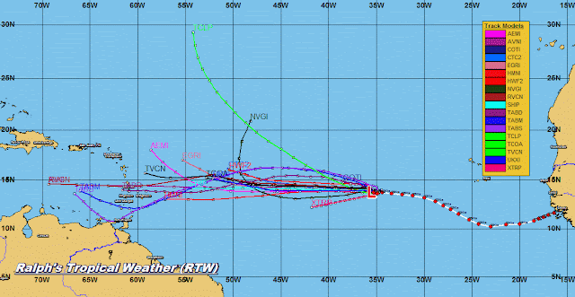
FLORENCE TRACKS AND MODELS

FLORENCE UPDATE
https://www.nhc.noaa.gov/

---------------------------------------------------------------------------------------------------------------------------
Florence poised to make landfall or side swipe the Carolinas.
 Models suggesting  possible landfall anywhere from South or N.Carolina to the Outer banks.
 Previous model run had a wider spread but still suggesting from South or N. Carolina to Outer banks.
 Candian CMC model also suggesting about the same.
 H-Models also suggest South or N. Carolina.
 United Kingdom model and National Hurricane Center model are some what in agreement in this model run.  Pointing to north Carolina.
 Intensity models suggesting a cat 4 Hurricane approaching the Carolina next week.
 

Saturday, September 8, 2018

UPDATES WILL BE LESS TODAY AND SUNDAY SEPT 8 2018

I WON'T BE POSTING ON BLOG SO MUCH TODAY WEBSITE TOOK TO MUCH TIME TO UPDATE WITH ALL THE STORMS AND MODELS I HAVE TO PUBLISH ON SITE.

SO USE LINK TO HURRICANE CENTER FOR UPDATE.  I WILL BE BACK LATER TO UPDATE WEBSITE AND HOPEFULLY THE BLOG AS WELL.

SATURDAY AND SUNDAYS ARE FAMILY TIME SO I CAN'T BE HERE DOING THESE REGULAR UPDATES.  I HOPE YOU UNDERSTAND.

RTW

Friday, September 7, 2018

FLORENCE, STORM INVEST 92L, T.D. EIGHT AND INVEST 94L UPDATE SEPT 7, 2018

Since there are to many weather systems I will ask you to click on NHC link so you can read text advisory.  I will post graphics for now and add my remarks on top of my graphic maps...RTW

FLORENCE UPDATE BY NHC
https://www.nhc.noaa.gov/

---------------------------------------------------------------------------------------------------------------------------

 Carolina's northward should prepared for the possibility of a major hurricane landfall if tracks verify
https://ralphstropicalweather.com/