Monday, September 24, 2018

TROPICAL UPDATE SEPT 24, 2018... 0326 PM EDT


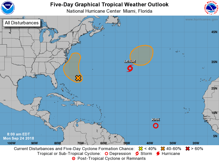
Kirk downgraded to a remnant low.  There still is a chance for Kirk to make a come back as it tracks futher west.  Kirk will have to slow down it's forward speed for that to happen though.  Kirk is back to being storm investigation 99L...RTW

Leslie stuck and no where to go.  Leslie is only a concern to shipping...RTW

Invest 98L Florence remnants continues to show signs of organzation and is poised to come back for the last time and brush the Outer Banks before going out to sea.

There is always that possibility that 98L could reach tropical storm strength before reaching close to the coast. This time there is a Cold front that will keep 98L off shore and help push it out to sea...RTW


TROPICAL UPDATE SEPT 24, 2018...1008 AM


Kirk doengraded to a depression is forecast to regain it's tropical storm status as it tracks further west.  

So far Kirk has a avoided dry air because it's been tracking at low latitudes and along the inter-tropical convergence zone where condition are more favorable.  

You might ask then why did it weaken to a depression?  

Well this storm system is tracking westward too fast, at a forward speed of 24 mph.  Storms traveling at these speeds produce their own wind shear separating the colder cloud tops from the center of circulation.  

So until this system slows down the likelihood of strengthening is low.  Kirk is forecast to weaken and disspipate in the Caribbean...RTW

As for Leslie that storm is stuck in a poor steering  environment and will be stuck in a loop over the north Atlantic.  Another low is forecast to develop north of Leslie they will more than likely interact weakening Leslie and then that system will be stuck in that loop as well...RTW

Invest 98L the left overs of Florence seems a bit better organized this morning with cold cloud tops blowing up around the low. 

This system will come close to the Outer Banks and produce rain and storm with sqaully conditions upon approach to this area.  

The only good news is that it will be moving along quickly and not hang around...RTW


Sunday, September 23, 2018

TROPICAL UPDATE SEPT 23, 2018 0814 PM EDT

1. Kirk is moving to fast for strengthening at this time.  Kirk is forecast to remain a tropical storm as it enters the Caribbean.  This storm system is forecast to weaken and dissipate as it reaches the Central Caribbean...RTW

2. Leslie is forecast to weaken and disspate in the next day or so.

3. Another storm is forecast to develop north of Leslie and spin around in circles until a front pulls the storm system northeast....RTW

4 Invest 98L remnants of Florence southwest of Bermuda is forecast to develop slightly as it curves northwest, north brushing the Outer Banks and northeast out to sea...RTW

So far the only system that will come close or make land fall or pass close to land is Kirk and 98L.  All other systems will remain out at sea...RTW


Saturday, September 22, 2018

TROPICAL DEPRESSION ELEVEN FORMS FROM INVEST 97L


200 
WTNT31 KNHC 220248
TCPAT1

BULLETIN
Tropical Depression Eleven Advisory Number   1
NWS National Hurricane Center Miami FL       AL112018
1100 PM AST Fri Sep 21 2018

...TROPICAL DEPRESSION FORMS EAST OF THE WINDWARD ISLANDS...
...FORECAST TO DISSIPATE WITHIN A FEW DAYS...


SUMMARY OF 1100 PM AST...0300 UTC...INFORMATION
-----------------------------------------------
LOCATION...13.1N 53.4W
ABOUT 510 MI...825 KM E OF THE WINDWARD ISLANDS
MAXIMUM SUSTAINED WINDS...35 MPH...55 KM/H
PRESENT MOVEMENT...WNW OR 290 DEGREES AT 6 MPH...9 KM/H
MINIMUM CENTRAL PRESSURE...1007 MB...29.74 INCHES


WATCHES AND WARNINGS
--------------------
There are no coastal watches or warnings in effect.


DISCUSSION AND OUTLOOK
----------------------
At 1100 PM AST (0300 UTC), the center of Tropical Depression Eleven
was located near latitude 13.1 North, longitude 53.4 West. The
depression is moving toward the west-northwest near 6 mph (9 km/h),
and this general motion will likely continue for the next couple
of days.

Maximum sustained winds are near 35 mph (55 km/h) with higher gusts.
Little change in strength is expected for the next day or two.  The
depression is forecast to dissipate late this weekend or early next
week before it reaches the Lesser Antilles.

The estimated minimum central pressure is 1007 mb (29.74 inches).


HAZARDS AFFECTING LAND
----------------------
None


NEXT ADVISORY
-------------
Next complete advisory at 500 AM AST.

$$
Forecaster Zelinsky 
---------------------------------------------------------------------
ralphstropicalweather.com
 TROPICAL DEPRESSION ELEVEN
ELEVEN WILL BE A SHORT LIVED SYSTEM DUE TO A HOSTILE ENVIRONMENT.  UPPER LEVEL WIND SHEAR WILL INCREASE EVEN MORE AS THIS SYSTEM TRACKS TOWARD THE LESSER ANTILLES.  THIS SYSTEM IS FORECAST TO DISSIPATE BEFORE REACHING THE ISLANDS...RTW
 STORM INVEST 98L
THE REMNANTS OF FLORENCE WILL COME CLOSE TO THE COAST THEN TURN BACK OUT TO SEA AS A FRONT SWEEPS IT EAST.
 STORM INVEST 99L
THIS SYSTEM HAS A CHANCE FOR FURTHER DEVELOPMENT BUT IT ALSO MOVES INTO A HOSTILE ENVIRONMENT WHEN IT REACHES THE LESSER ANTILLES NEXT WEEK...RTW
  

Friday, September 21, 2018

TROPICAL UPDATE SEPT 21, 2018... 0336 PM EDT


Invest 97L still encountering upper level shear development if any will be slow to occur.

Invest 98L still lacking thunderstorm activity.  Development if any will be slow to occur.

Invest 99L continues to look good on satellite and NHC raised the chance for development within 48 hrs to 30%.