Tuesday, September 25, 2018

TROPICAL UPDATE SEPT 25, 2018...0354 PM EDT

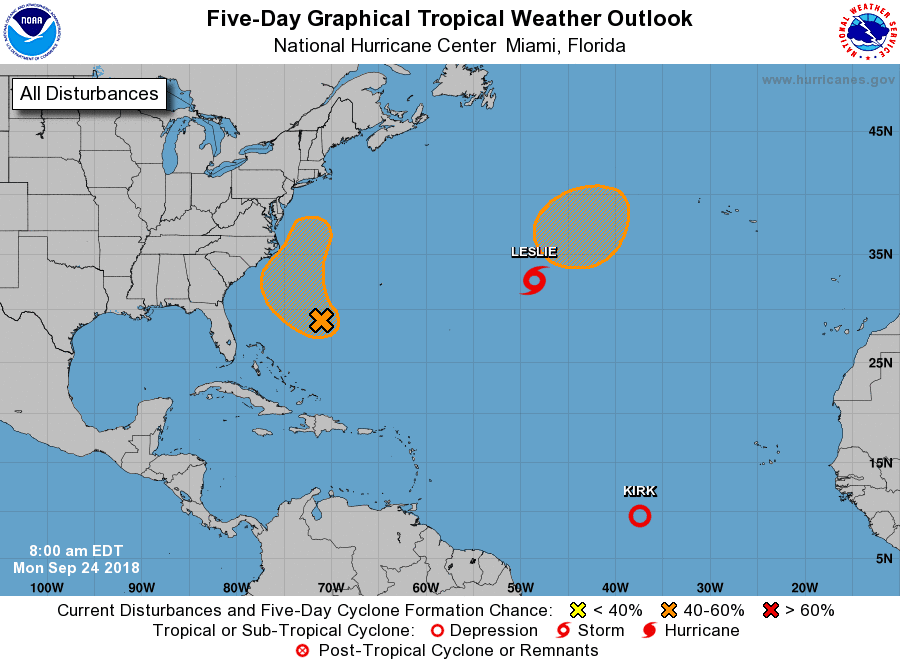
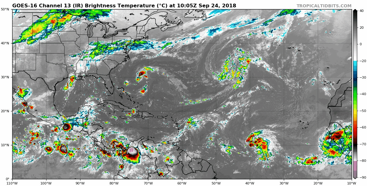
Kirk trying to reorganize dispite how fast it's moving.  Kirk could regain tropical storm status at anytime.  

The residents of the Windward and Leeward Islands should closely monitor the progress of Kirk.  

Heavy rains and squally conditions will pass over the islands in the coming days.  

After that Kirk is forecast to encounter strong upper level wind shear and dissipate...RTW

Leslie is no longer, this system will now be replaced by another stronger low which more than likely intensify to a sub-tropical storm or tropical storm Michael.  This storm system will meander in north Central Atlantic until a frontal boundary sweeps it out to sea...RTW

Invest 98L will stay off shore the Outer Banks of the Carolinas producing rough surf and rip tides and enhance the storm chance for the coastal areas of the Outer Banks. There still a chance that 98L could strengthen to a depression or tropical storm...RTW


TROPICAL UPDATE SEPT 25, 2018... 1141 AM EDT


Remnants of Kirk are still producing strong thunderstorms, however Kirk is still moving to fast 25 mph for rapid development.  If Kirk slows down before reaching hostile conditions near the Lesser Antilles, then Kirk could regain tropical storm status. 

Interest in the Lesser Antilles should monitor the progress of Kirk as Gusty winds and heavy rains will be moving through the Islands in the coming days...RTW

Leslie will become a post tropical in a day or so and a new low will develop making Leslie a strong sub-tropical cyclone in the north Central Atlantic.  This storm system remains stuck in a weak steering environment and will continue to meander.  Only a threat to shipping...RTW

Invest 98L is getting close to the outer banks.  This system is encountering dry air and upper level shear along the west quadrant.  Sea surface temps are also cooler in this area due to Florence had slowly passed over this area.  Rip currents windy conditions affecting the coast but heavy rains remain off shore.  You can't rule out some showers and storms along the outer Banks...RTW


Monday, September 24, 2018

TROPICAL UPDATE SEPT 24, 2018... 0326 PM EDT


Kirk downgraded to a remnant low.  There still is a chance for Kirk to make a come back as it tracks futher west.  Kirk will have to slow down it's forward speed for that to happen though.  Kirk is back to being storm investigation 99L...RTW

Leslie stuck and no where to go.  Leslie is only a concern to shipping...RTW

Invest 98L Florence remnants continues to show signs of organzation and is poised to come back for the last time and brush the Outer Banks before going out to sea.

There is always that possibility that 98L could reach tropical storm strength before reaching close to the coast. This time there is a Cold front that will keep 98L off shore and help push it out to sea...RTW


TROPICAL UPDATE SEPT 24, 2018...1008 AM


Kirk doengraded to a depression is forecast to regain it's tropical storm status as it tracks further west.  

So far Kirk has a avoided dry air because it's been tracking at low latitudes and along the inter-tropical convergence zone where condition are more favorable.  

You might ask then why did it weaken to a depression?  

Well this storm system is tracking westward too fast, at a forward speed of 24 mph.  Storms traveling at these speeds produce their own wind shear separating the colder cloud tops from the center of circulation.  

So until this system slows down the likelihood of strengthening is low.  Kirk is forecast to weaken and disspipate in the Caribbean...RTW

As for Leslie that storm is stuck in a poor steering  environment and will be stuck in a loop over the north Atlantic.  Another low is forecast to develop north of Leslie they will more than likely interact weakening Leslie and then that system will be stuck in that loop as well...RTW

Invest 98L the left overs of Florence seems a bit better organized this morning with cold cloud tops blowing up around the low. 

This system will come close to the Outer Banks and produce rain and storm with sqaully conditions upon approach to this area.  

The only good news is that it will be moving along quickly and not hang around...RTW