Wednesday, September 26, 2018

TROPICAL UPDATE SEPT 26, 2018 11.56 PM EDT


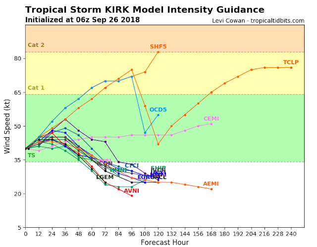
Kirk continues to gradually weaken as it tracks into a hostile shear environment near the Lesser Antilles and the Eastern Caribbean.  I mentioned this in my previous afternoon update.  Air Force Recon found rising pressure around 0800 PM EDT and now a weaker tropical storm at 11 PM EDT.

Satellite shows another small burst of convection as Kirk makes another attempt at reorganization and a temporary strengthening. This won't last long as relentless wind shear begins to separate the colder cloud tops from the center of circulation.   As the storm system weakens the wind field expands in coverage.

Squally conditions and localized heavy rains will begin to spread across the islands as early as tomorrow evening...RTW


TROPICAL UPDATE SEPT 26, 2018...0448 PM EDT


This update will be dedicated to Kirk since it's the only storm system threatening land.

Kirk has been gradually strengthening even though it has been encountering southwesterly shear.

Satellite this afternoon shows upper level winds disrupting the west quadrant of the tropical cyclone, and these winds are increasing as Kirk reaches the islands.

Kirk is forecast to pass over the islands as a tropical storm but the likelihood of further strengthening is low.  Upper level shear in the Eastern Caribbean is very hostile and this should weaken Kirk to a depression and eventually to remnant low.  Most models show Kirk dissipating in the Caribbean.

Residents of the northern Windward and Leeward Islands should prepare for tropical storm conditions and localized heavy rainfall...RTW


TROPICAL UPDATE SEPT 26, 2018...0910 AM EDT


Kirk restrengthens to a tropical storm last night.  Kirk will be a short live tropical storm as it moves into the Eastern Caribbean.  Upper level wind shear will be present and Kirk is forecast to dissipate...RTW

98L off near the outer Banks and void of thunderstorms on the west side of this system.  This means that all the heavy rains and storms remain to the east of the weak center...RTW

Post tropical Leslie will more than likely be be replaced by a new and stronger low and will be named Michael if that occurs.  This storm system will be meander for days on end until a frontal boundary comes aalon and sweeps it to the northeast...RTW


Tuesday, September 25, 2018

TROPICAL UPDATE SEPT 25, 2018...0354 PM EDT

Kirk trying to reorganize dispite how fast it's moving.  Kirk could regain tropical storm status at anytime.  

The residents of the Windward and Leeward Islands should closely monitor the progress of Kirk.  

Heavy rains and squally conditions will pass over the islands in the coming days.  

After that Kirk is forecast to encounter strong upper level wind shear and dissipate...RTW

Leslie is no longer, this system will now be replaced by another stronger low which more than likely intensify to a sub-tropical storm or tropical storm Michael.  This storm system will meander in north Central Atlantic until a frontal boundary sweeps it out to sea...RTW

Invest 98L will stay off shore the Outer Banks of the Carolinas producing rough surf and rip tides and enhance the storm chance for the coastal areas of the Outer Banks. There still a chance that 98L could strengthen to a depression or tropical storm...RTW


TROPICAL UPDATE SEPT 25, 2018... 1141 AM EDT


Remnants of Kirk are still producing strong thunderstorms, however Kirk is still moving to fast 25 mph for rapid development.  If Kirk slows down before reaching hostile conditions near the Lesser Antilles, then Kirk could regain tropical storm status. 

Interest in the Lesser Antilles should monitor the progress of Kirk as Gusty winds and heavy rains will be moving through the Islands in the coming days...RTW

Leslie will become a post tropical in a day or so and a new low will develop making Leslie a strong sub-tropical cyclone in the north Central Atlantic.  This storm system remains stuck in a weak steering environment and will continue to meander.  Only a threat to shipping...RTW

Invest 98L is getting close to the outer banks.  This system is encountering dry air and upper level shear along the west quadrant.  Sea surface temps are also cooler in this area due to Florence had slowly passed over this area.  Rip currents windy conditions affecting the coast but heavy rains remain off shore.  You can't rule out some showers and storms along the outer Banks...RTW