Monday, April 8, 2019

SLIGHT RISK FOR SEVERE WEATHER TODAY

Strong weather system tracking east is producing a strong to severe line with embedded hail, Gusty winds, frequent lightning and possible tornado.

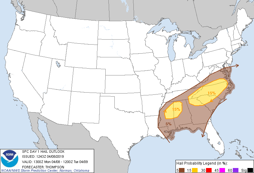
This system will be affecting northeast Mississippi the Carolinas, southeast Virginia this evening.

The tail end of this systems will drag a squall line early today affecting the Florida Panhandle and Alabama and Georgia.

This line is producing allot of lightning as it moves over the northeast Gulf waters.


Thursday, April 4, 2019

LIGHTNING HAS BEEN STRIKING OUT 50 MILES FROM THUNDERHEAD THIS MORNING

It's pretty amazing to see lightning striking out ahead of some of these cells tracking east toward Alabama.  There has been some cells producing lightning as far out as 50 miles from the thunderhead.

Generally speaking lightning strikes usually 30 to 35 miles ahead of a thunderhead but this storm has plenty of energy to produce strikes further out.

This is why if you see lightning or hear thunder at at a distance you should head indoors.

Stormy southeast with plenty convective activity, and frequent lightning.


NEW EVENT MARINE WARNING NWS MIAMI

GMZ035-044-054-040530-
/O.NEW.KKEY.MA.W.0046.190404T0501Z-190404T0530Z/

BULLETIN - IMMEDIATE BROADCAST REQUESTED
Special Marine Warning
National Weather Service Key West FL
101 AM EDT THU APR 4 2019

The National Weather Service in Key West has issued a

* Special Marine Warning for...
Hawk Channel and Straits of Florida from west end of Seven Mile
Bridge to Halfmoon Shoal out 20 nm...
Gulf of Mexico from west end of Seven Mile Bridge to Halfmoon Shoal
out to 5 fathoms...

* Until 130 AM EDT.

* At 101 AM EDT, a strong thunderstorm was located over Pelican
Shoal. The strong thunderstorm was nearly stationary.

HAZARD...Wind gusts 34 knots or greater.

SOURCE...National Weather Service Meteorologist.

IMPACT...Expect wind gusts in excess of 34 knots, suddenly higher
waves, frequent lightning, and very heavy downpours.

* Locations in the warning include...
Western Sambo, Vandenberg, Joe's Tug, Pelican Shoal, East Sambo,
Snipe Point and Ninefoot Shoal.

LAT...LON 2471 8167 2464 8149 2439 8167 2447 8187
2471 8174
TIME...MOT...LOC 0501Z 035DEG 3KT 2454 8165

HAIL...0.00IN
WIND...>34KTS

SPECIAL MARINE WARNING LOWER FLORIDA KEYS

GMZ035-044-040500-
/O.NEW.KKEY.MA.W.0045.190404T0430Z-190404T0500Z/

BULLETIN - IMMEDIATE BROADCAST REQUESTED
Special Marine Warning
National Weather Service Key West FL
1230 AM EDT THU APR 4 2019

The National Weather Service in Key West has issued a

* Special Marine Warning for...
Gulf of Mexico from west end of Seven Mile Bridge to Halfmoon Shoal
out to 5 fathoms...
Hawk Channel from west end of Seven Mile Bridge to Halfmoon Shoal
out to the reef...

* Until 100 AM EDT.

* At 1230 AM EDT, a strong thunderstorm was located near Snipe Point.
The strong thunderstorm was nearly stationary.

HAZARD...Wind gusts 34 knots or greater.

SOURCE...National Weather Service Meteorologist.

IMPACT...Expect wind gusts in excess of 34 knots, suddenly higher
waves, frequent lightning, and very heavy downpours.

* Locations in the warning include...
Stock Island, Cudjoe Bay, Raccoon Key, Snipe Point and Ninefoot
Shoal.

LAT...LON 2479 8162 2477 8149 2468 8146 2456 8155
2449 8170 2453 8176 2463 8180 2471 8176
TIME...MOT...LOC 0430Z 035DEG 4KT 2468 8159

HAIL...0.00IN
WIND...>34KTS

Wednesday, April 3, 2019

Tuesday, March 26, 2019

SIGNIFICANT WEATHER ADVISORY NWS MIAMI

FLZ068-072-168-172-262315-
Coastal Broward County FL-Coastal Palm Beach County FL-
Metro Broward County FL-Metro Palm Beach County FL-
651 PM EDT Tue Mar 26 2019

...SIGNIFICANT WEATHER ADVISORY FOR NORTHERN BROWARD AND SOUTHEASTERN
PALM BEACH COUNTIES UNTIL 715 PM EDT...

* At 651 PM EDT, National Weather Service meteorologists were
tracking a strong thunderstorm over Boca Raton, moving southeast at
15 mph.

* Small hail and funnel clouds possible with this storm.

* Locations impacted include...
Pompano Beach, Boca Raton, Deerfield Beach, Boynton Beach, Delray
Beach, Lighthouse Point, Highland Beach, Coconut Creek, Hillsboro
Beach, Boca Pointe, Boca Del Mar, Hamptons At Boca Raton, Village
Of Golf, Kings Point, Dunes Road, Whisper Walk, Gulf Stream, Fau
South Campus, Hillsboro Ranches and Boca West.

PRECAUTIONARY/PREPAREDNESS ACTIONS...

This activity was also developing in an environment favorable for the
formation of funnel clouds. Stay tuned to NOAA weather radio and
local media for additional updates and possible warnings.

To report severe weather, contact your nearest law enforcement
agency. You can also share your report with NWS Miami on Facebook and
Twitter.


Friday, March 22, 2019

COASTAL FLOOD EVENT CANCELLED BY NWS MIAMI, FLORIDA

FLZ069-168-172>174-222115-
/O.CAN.KMFL.CF.S.0001.000000T0000Z-190323T0400Z/
Coastal Collier-Coastal Palm Beach-Coastal Broward-Coastal Miami-
Dade-Far South Miami-Dade-
409 PM EDT Fri Mar 22 2019

...THE COASTAL FLOOD STATEMENT HAS BEEN CANCELED...

The coastal flood statement has been canceled. Tide levels are no
longer high enough to cause coastal flooding issues.


Thursday, March 21, 2019

COASTAL FLOOD STATEMENT N.W.S. MIAMI


FLZ168-172>174-221000-
/O.NEW.KMFL.CF.S.0001.190321T1835Z-190323T0400Z/
Coastal Palm Beach-Coastal Broward-Coastal Miami-Dade-
Far South Miami-Dade-
235 PM EDT Thu Mar 21 2019

...ELEVATED WATER LEVELS AROUND HIGH TIDE THROUGH FRIDAY NIGHT...

* COASTAL FLOODING...Locations along the Atlantic coast and
intracoastal waterways may experience minor inundation near the
times of high tide.

* TIMING...High tide times are between 9 and 11 PM tonight and
Friday night, and between 9 AM and 11 AM Friday morning. 

* IMPACTS...Tide levels of about 1 foot above the predicted
astronomical tide could result in minor ponding of water on
streets, parking lots, piers, and docks in the most vulnerable
locations along the coast and intracoastal waterways.


Monday, March 18, 2019

HEAVY RAINS HEADED FOR FLORIDA

Low pressure from the Gulf I been talking about here on this blog is headed for the Southern Peninsula of Florida tonight and Tuesday.

This low could bring heavy rains and thunderstorms with the potential for possible localized flooding as it trains over the same area late tonight, and on Tuesday. 

With the development of thunderstorms there is always a chance for some cells to turn severe...RTW

DAY-1 RAINFALL OUTLOOK
DAY-2 RAINFALL OUTLOOK
 DAY-2 THUNDERSTORM OUTLOOK
 GFS FORECAST MODEL
 GOES 16 INFRARED COLOR SATELLITE

Friday, March 15, 2019

SOME MODELS STILL HINTING STORMY WEATHER FOR FLORIDA NEXT WEEK

Still monitoring the models for possible development of a weak low pressure disturbance coming out of the western Gulf from the tail end of the winter storm tracking east. 

The arrival of this storminess if at all will be mid next week. 

There is nothing significant showing up on models at this time, but this system could produce heavy downpours, Gusty winds and maybe some strong to severe storms. 

It's is all questionable at this time but I will keep watching...RTW