(LAST ADVISORY)
922
WTNT33 KNHC 121509 CCA
TCPAT3

BULLETIN
Post-Tropical Cyclone Chris Advisory Number  24...Corrected
NWS National Hurricane Center Miami FL       AL032018
1100 AM AST Thu Jul 12 2018

Corrected Discussion and Outlook Section

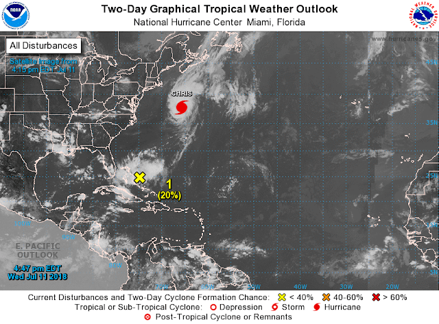
...POST-TROPICAL CYCLONE CHRIS RACING TOWARD CAPE RACE AND THE
AVALON PENINSULA OF NEWFOUNDLAND...
...THIS IS THE LAST ADVISORY...


SUMMARY OF 1100 AM AST...1500 UTC...INFORMATION
-----------------------------------------------
LOCATION...44.4N 57.7W
ABOUT 290 MI...470 KM E OF HALIFAX NOVA SCOTIA
ABOUT 275 MI...440 KM SW OF CAPE RACE NEWFOUNDLAND
MAXIMUM SUSTAINED WINDS...70 MPH...110 KM/H
PRESENT MOVEMENT...NE OR 45 DEGREES AT 36 MPH...57 KM/H
MINIMUM CENTRAL PRESSURE...987 MB...29.15 INCHES


WATCHES AND WARNINGS
--------------------
There are no tropical cyclone coastal watches or warnings in effect.

Interests in Atlantic Canada should monitor the progress of Chris.


DISCUSSION AND OUTLOOK
----------------------
At 1100 AM AST (1500 UTC), the center of Post-Tropical Cyclone
Chris was located near latitude 44.4 North, longitude 57.7 West.
The post-tropical cyclone is moving toward the northeast near
36 mph (57 km/h) and this motion is expected to continue through
Friday. On the forecast track, Chris is expected to pass over or
near the Avalon Peninsula of southeastern Newfoundland late
afternoon and early evening today.

Maximum sustained winds are near 70 mph (110 km/h) with higher
gusts.  Slight weakening is forecast during the next 48 hours.

Tropical-storm-force winds extend outward up to 205 miles (335 km)
from the center. A Canadian buoy just east of the center recently
reported a sustained wind of 58 mph (94 km/h) and gust to 71 mph
(115 km/h).

The estimated minimum central pressure is 987 mb (29.15 inches).


HAZARDS AFFECTING LAND
----------------------
SURF:  Even though Chris is moving away from the United States,
swells generated by the storm will affect portions of the coast from
North Carolina northward to New England during the next couple of
days.  Swells will spread northward along the southern coasts of
Nova Scotia and Newfoundland overnight and into Thursday.  These
swells could cause life-threatening surf and rip current conditions.
Please consult products from your local weather office.

RAINFALL: Chris is expected to produce total rain accumulations of
1 to 3 inches (25 to 75 millimeters) over Newfoundland, with
possible isolated maximum amounts of 6 inches (150 millimeters).
These rains may cause flash flooding.  Sable Island has received
more than 2.3 inches (60 millimeters) of rainfall during the past
few hours.


NEXT ADVISORY
-------------
This is the last public advisory issued by the National Hurricane
Center on this system.  Additional information on this system can be
found in High Seas Forecasts issued by the National Weather Service,
under AWIPS header NFDHSFAT1, WMO header FZNT01 KWBC, and available
on the Web at https://ocean.weather.gov/shtml/NFDHSFAT1.shtml. Other
information on Post-Tropical Cyclone Chris can be found in products
issued by Environment Canada/Canadian Hurricane Centre on the
internet at  weather.gc.ca/hurricane/.

$$
Forecaster Stewart https://www.nhc.noaa.gov/
ralphstropicalweather.com
BERYL'S REMNANTS (INVEST 95L)
123
ABNT20 KNHC 121128
TWOAT

Tropical Weather Outlook
NWS National Hurricane Center Miami FL
800 AM EDT Thu Jul 12 2018

For the North Atlantic...Caribbean Sea and the Gulf of Mexico:

The National Hurricane Center is issuing advisories on recently
downgraded Tropical Storm Chris, located about 400 miles southwest
of Cape Race, Newfoundland.

An area of disorganized showers and thunderstorms associated with
the remnants of Beryl is located about midway between the Bahamas
and Bermuda.  Little or no development is expected through Friday
while the system moves northeastward.  However, environmental
conditions could become a little more favorable over the weekend
when the disturbance will be moving northward over the warm waters
of the western Atlantic and interacting with a strong upper-level
trough.
* Formation chance through 48 hours...low...10 percent.
* Formation chance through 5 days...medium...50 percent.

$$
Forecaster Stewart


No comments:
Post a Comment
Note: Only a member of this blog may post a comment.