
000
WTNT32 KNHC 080853
TCPAT2

BULLETIN
Tropical Storm Beryl Advisory Number  12
NWS National Hurricane Center Miami FL       AL022018
500 AM AST Sun Jul 08 2018

...BERYL MOVING WEST-NORTHWESTWARD TOWARD THE LESSER ANTILLES...
...RECONNAISSANCE AIRCRAFT EN ROUTE TO THE STORM...


SUMMARY OF 500 AM AST...0900 UTC...INFORMATION
----------------------------------------------
LOCATION...13.7N 56.0W
ABOUT 240 MI...380 KM E OF BARBADOS
ABOUT 340 MI...550 KM E OF MARTINIQUE
MAXIMUM SUSTAINED WINDS...45 MPH...75 KM/H
PRESENT MOVEMENT...WNW OR 290 DEGREES AT 20 MPH...31 KM/H
MINIMUM CENTRAL PRESSURE...1005 MB...29.68 INCHES


WATCHES AND WARNINGS
--------------------
CHANGES WITH THIS ADVISORY:

The government of St. Lucia has discontinued the Tropical Storm
Watch for St. Lucia.

SUMMARY OF WATCHES AND WARNINGS IN EFFECT:

A Tropical Storm Warning is in effect for...
* Dominica
* Guadeloupe

A Tropical Storm Watch is in effect for...
* Barbados
* Martinique, St. Martin, and St. Barthelemy
* Saba and St. Eustatius
* St. Maarten

A Tropical Storm Warning means that tropical storm conditions are
expected somewhere within the warning area.

A Tropical Storm Watch means that tropical storm conditions are
possible within the watch area.

Interests elsewhere in the Leeward Islands, the Virgin Islands,
Puerto Rico, and the Dominican Republic should monitor the progress
of Beryl.

For storm information specific to your area, please monitor
products issued by your national meteorological service.


DISCUSSION AND OUTLOOK
----------------------
At 500 AM AST (0900 UTC), the center of Tropical Storm Beryl was
located near latitude 13.7 North, longitude 56.0 West. Beryl is
moving toward the west-northwest near 20 mph (31 km/h) and this
motion with an increase in forward speed is expected during the
next couple of days.  On the forecast track, the center of Beryl
will approach the Lesser Antilles today, cross the island chain
tonight, and move near or south of the Virgin Islands and Puerto
Rico on Monday.

Maximum sustained winds are near 45 mph (75 km/h) with higher gusts.
Gradual weakening is forecast during the next 48 hours, and Beryl is
forecast to degenerate into a trough of low pressure as it moves
across the eastern Caribbean Sea on Monday.

Tropical-storm-force winds extend outward up to 45 miles (75 km)
from the center.

The estimated minimum central pressure is 1005 mb (29.68 inches).


HAZARDS AFFECTING LAND
----------------------
WIND:  Tropical storm conditions are expected in Dominica and
Guadeloupe tonight.  Tropical storm conditions are possible
in the watch areas of the Lesser Antilles by later today or Monday.
Strong gusty winds are also possible in the Virgin Islands and
Puerto Rico on Monday.

RAINFALL:  Beryl is expected to produce total rain accumulations of
1 to 3 inches through Monday across the southern Leeward and
northern Windward Islands.  Across Puerto Rico, rainfall amounts of
1 to 4 inches are expected.  Across the remainder of the Leeward
and Windward Islands and the Virgin Islands, rainfall amounts of
1 to 2 inches are expected, with locally higher amounts possible.


NEXT ADVISORY
-------------
Next intermediate advisory at 800 AM AST.
Next complete advisory at 1100 AM AST.

$$
Forecaster Brown https://www.nhc.noaa.gov/


Beryl has been struggling to keep it together. Over night it went through a burst of thunderstorms
trying to reorganize. Air Force Recon is scheduled to investigate Beryl this morning...RTW
RTW FORECAST TRACK MAP
(Data courtesy of NHC)

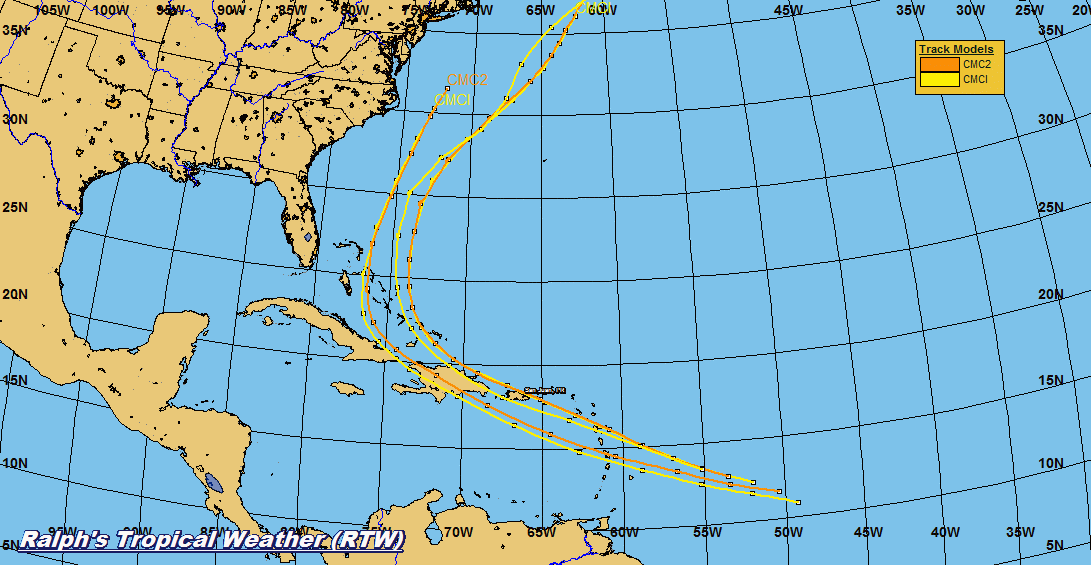


(Courtesy of Tropical Tidbits)

CHRIS
000
WTNT33 KNHC 080951 CCA
TCPAT3

BULLETIN
Tropical Storm Chris Advisory Number   7...Corrected
NWS National Hurricane Center Miami FL       AL032018
500 AM EDT Sun Jul 08 2018

Corrected wording in hazards section

...DEPRESSION BECOMES TROPICAL STORM CHRIS...
...FURTHER STRENGTHENING IS LIKELY WHILE IT MEANDERS OFF THE
CAROLINA COAST...


SUMMARY OF 500 AM EDT...0900 UTC...INFORMATION
----------------------------------------------
LOCATION...33.0N 75.5W
ABOUT 150 MI...245 KM S OF CAPE HATTERAS NORTH CAROLINA
MAXIMUM SUSTAINED WINDS...40 MPH...65 KM/H
PRESENT MOVEMENT...STATIONARY
MINIMUM CENTRAL PRESSURE...1010 MB...29.83 INCHES


WATCHES AND WARNINGS
--------------------
There are no coastal watches or warnings in effect.

Interests along the coast of North Carolina should monitor the
progress of this system.


DISCUSSION AND OUTLOOK
----------------------
At 500 AM EDT (0900 UTC), the center of Tropical Storm Chris was
located by an Air Force Reserve hurricane hunter aircraft near
latitude 33.0 North, longitude 75.5 West. Chris is forecast to
meander off the coast of the Carolinas for the next several days.
An acceleration toward the northeast is expected to begin on
Tuesday.

Data from an Air Force Reserve reconnaissance aircraft indicate that
the maximum sustained winds have increased to near 40 mph (65 km/h)
with higher gusts.  Additional strengthening is forecast, and Chris
is expected to become a hurricane by mid-week.

Tropical-storm-force winds extend outward up to 60 miles (95 km)
from the center.

The estimated minimum central pressure from reconnaissance data is
1010 mb (29.83 inches).


HAZARDS AFFECTING LAND
----------------------
SURF:  Swells generated by Chris are expected to increase and affect
portions of the coasts of North Carolina and the mid-Atlantic states
into early next week.  These swells could cause life-threatening
surf and rip current conditions.  Please consult products from your
local weather office.

WIND:  Winds to gale force not directly associated with Chris are
expected along the North Carolina coast and over Pamlico and
Albemarle Sounds during the next day or so.


NEXT ADVISORY
-------------
Next complete advisory at 1100 AM EDT.

$$
Forecaster Zelinsky https://www.nhc.noaa.gov/


NHC names the third depression tropical storm Chris this morning. Chris continues in a weak
steering pattern due to blocking high pressures. Chris is forecast the meander off the east coast
before beginning a track toward the north-northeast. Chris is forecast to strengthen as it begins
to move away from the Carolina coast...RTW
RTW FORECAST TRACK MAP
(Data courtesy of NHC)


INTENSITY MODEL RUN
(Courtesy of Tropical Tidbits)

No comments:
Post a Comment
Note: Only a member of this blog may post a comment.