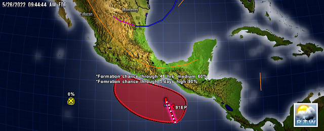
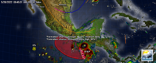
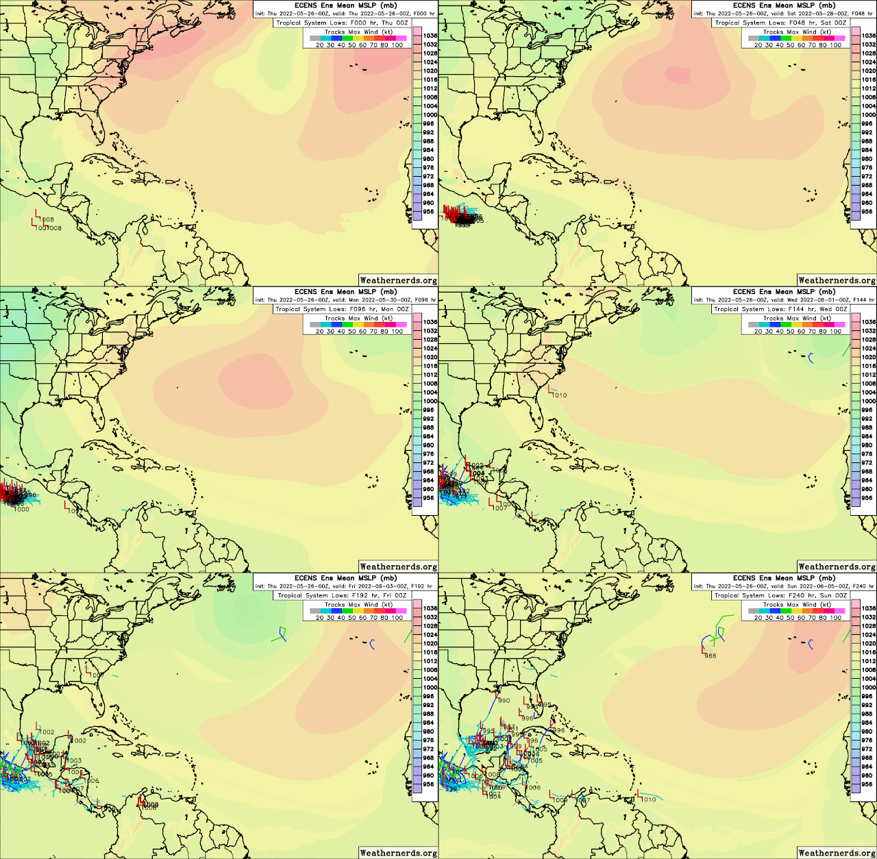
Models still to confused, and still insisting on storm development south of Mexico. I been using the 00z and 12z run because they seem to be more complete than the others. They still suggesting a cross over in the the Gulf of even Caribbean so continue to monitor closely as we near the Start of the 2022 Atlantic Hurricane season.
Elsewhere there are three waves which are interacting with the monsoon trough and the inter-tropical convergence zone. These areas of showers and storms are mainly due too the interaction and not so much with the wave itself.
RTW
Refer to NHC Tropical Outlook Discussions below:
000
ABPZ20 KNHC 261140
TWOEP

Tropical Weather Outlook
NWS National Hurricane Center Miami FL
500 AM PDT Thu May 26 2022

For the eastern North Pacific...east of 140 degrees west longitude:

South of the Gulf of Tehuantepec:
Shower and thunderstorm activity has increased and become a bit more
concentrated near a surface trough located a few hundred miles
south-southeast of the Gulf of Tehuantepec.  Environmental
conditions appear conducive for gradual development, and a tropical
depression is likely to form by this weekend while the system moves
west-northwestward or northwestward at 5 to 10 mph.  Interests in
southern Mexico should monitor the progress of this system.
* Formation chance through 48 hours...medium...60 percent.
* Formation chance through 5 days...high...90 percent.

Central portion of the eastern Pacific:
Shower and thunderstorm activity has diminished in association with
the trough of low pressure located several hundred miles off the
coast of southwestern Mexico. Environmental conditions are becoming
increasingly unfavorable, and significant development of this
system is no longer expected.
* Formation chance through 48 hours...low...near 0 percent.
* Formation chance through 5 days...low...near 0 percent.

$$
Forecaster Papin
-------------------------------------------------------------------
000
AXNT20 KNHC 261032
TWDAT

Tropical Weather Discussion
NWS National Hurricane Center Miami FL
1205 UTC Thu May 26 2022

Tropical Weather Discussion for North America, Central America
Gulf of Mexico, Caribbean Sea, northern sections of South
America, and Atlantic Ocean to the African coast from the
Equator to 31N. The following information is based on satellite
imagery, weather observations, radar and meteorological analysis.

Based on 0600 UTC surface analysis and satellite imagery through
0955 UTC.

...TROPICAL WAVES...

An Atlantic Ocean tropical wave is along 15W, south of 13N and moving
westward at 10-15 kt. Interaction between the wave and the monsoon
trough results in scattered moderate to isolated strong convection
from 02N to 11N and E of 19W.

An Atlantic Ocean tropical wave is along 39W, south of 10N and moving
westward at 10-15 kt. No deep convection is associated with this
feature.

A Caribbean Sea tropical wave is along 79W, south of 17N and
moving westward near 10 kt. Interaction between the wave and the
East Pacific monsoon trough allows for a few showers near the
trough axis in the Caribbean Sea and strong thunderstorms over the
Gulf of Panama on the Pacific side.

...MONSOON TROUGH/ITCZ...

The monsoon trough enters the Atlantic through the coast of
Guinea-Bissau near 12N16W and continues to 03N31W. The ITCZ
extends from 03N31W to 01N38W and then from 01N41W to 00N50W.
Scattered moderate to isolated strong convection is observed S of
05N and between 19W and 28W. Similar convection is noted S of 04N
and W of 40W.

GULF OF MEXICO...

A weak cold front extends from 30N92W in southern Louisiana to
24N97W in Tamaulipas, Mexico. A few showers and isolated
thunderstorms are noted ahead of the frontal boundary in the
northern and NE Gulf, mainly N of 26N. A dry environment dominates
the NW Gulf behind the frontal boundary. Another area of unstable
weather is found in the Bay of Campeche due a large area of
showers and thunderstorms affecting SE Mexico and Guatemala,
extending into the southern Bay of Campeche. Fresh to locally
strong winds are found ahead of the cold front, especially in the
central and eastern Gulf, while gentle to moderate flow is present
behind the front. A scatterometer satellite pass from a few hours
ago also captured fresh to strong winds in association with the
activity in the Bay of Campeche, which is expected to diminish in
the next few hours. Seas of 4-7 ft are occurring over most of the
Gulf, except for 2-4 ft in the Bay of Campeche.

For the forecast, the aforementioned cold front will continue
pushing eastward through the northern basin over the next few
days, weakening as it reaches the NE Gulf by Friday. Showers and
thunderstorms are expected to persist ahead of the front through
this time. By the weekend, high pressure will settle over the
basin, allowing winds to diminish.

CARIBBEAN SEA...

The moderate pressure gradient between the subtropical ridge
north of the Caribbean Sea and lower pressures in northern South
America and the tropical East Pacific result in moderate to
locally strong trades across most of the Caribbean Sea.
Satellite- derived wind data from a few hours ago captured a large
area of fresh to locally strong winds in the central Caribbean
Sea, with the strongest winds occurring offshore Venezuela and
Colombia. Fresh to locally strong trades are also pulsing in the
Bay of Campeche. Seas of 5-8 ft are prevalent in the central
Caribbean Sea and Gulf of Honduras, while 3-5 ft are noted
elsewhere in the basin.

In the forecast, the subtropical ridge north of the area will
support moderate to fresh trades across most of the Caribbean
during the next few days. Winds will pulse to strong north of
Honduras tonight. Fresh to strong winds will also pulse off
Colombia and Venezuela at night through the weekend and into early
next week

ATLANTIC OCEAN...

High pressure dominates most of the tropical Atlantic, supporting
fairly tranquil weather conditions. A surface trough enters the
basin near 31N38W and continues southwestward to 22N50W. A few
weak showers are seen near the trough axis. Moderate to locally
fresh southerly flow is present N of 29N and between 33W and 42W.
Elsewhere, moderate to locally fresh E-SE winds are found north
of Hispaniola, across the Bahamas and offshore NE Florida. Similar
winds are also affecting the waters S of 15N and between 45W and
the Lesser Antilles. Seas across the basin are 3-6 ft.

For the forecast W of 55W, the subtropical ridge over the western
Atlantic will shift eastward this morning through Fri night ahead
of a cold front that will move across the southeastern U.S. The
associated pressure gradient will allow for gentle to moderate
winds to prevail across most of the region through the period.
Winds off the NE Florida coast will become moderate to locally
strong ahead of the cold front tonight into Fri night. Winds will
also pulse moderate to fresh over northern Hispaniola and the
Bahamas.

$$
Delgado 


.png)

.png)
.gif)
No comments:
Post a Comment
Note: Only a member of this blog may post a comment.