
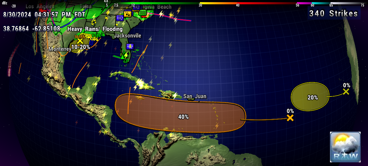
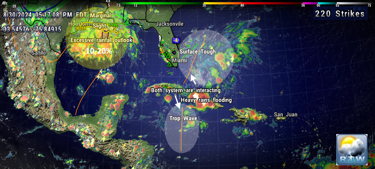
000
ABNT20 KNHC 301750
TWOAT

Tropical Weather Outlook
NWS National Hurricane Center Miami FL
200 PM EDT Fri Aug 30 2024

For the North Atlantic...Caribbean Sea and the Gulf of Mexico:

Northwestern Gulf of Mexico:
A surface trough of low pressure over the northwestern Gulf of
Mexico is producing a large area of disorganized showers and
thunderstorms along and just offshore the coasts of Texas and
Louisiana.  This system is expected to meander near the coast
through much of next week, and some slow development is possible if
it remains offshore.  Regardless of development, heavy rains could
cause some flash flooding across portions of coastal Louisiana and
the upper Texas coast during the next few days.
* Formation chance through 48 hours...low...10 percent.
* Formation chance through 7 days...low...20 percent.

Near the Lesser Antilles and Caribbean Sea:
Showers and thunderstorms associated with a tropical wave over the
central tropical Atlantic remain disorganized.  Gradual development
of this system is possible during the next few days, and a tropical
depression could form some time next week while it moves westward,
reaching the Lesser Antilles on Monday and continuing across the
Caribbean Sea through the middle to latter part of the week.
* Formation chance through 48 hours...low...near 0 percent.
* Formation chance through 7 days...medium...40 percent.

Eastern Tropical Atlantic:
Another tropical wave between the west coast of Africa and the Cabo
Verde Islands is producing minimal shower and thunderstorm
activity.  Some slow development of this system is possible through
late next week while it moves slowly to the west-northwest over the
eastern and central tropical Atlantic.
* Formation chance through 48 hours...low...near 0 percent.
* Formation chance through 7 days...low...20 percent.

$$
Forecaster Berg
---------------------------------------------------------------------
729
ACCA62 KNHC 301752
TWOSAT

Perspectiva sobre las Condiciones del Tiempo en el Trópico
Centro Nacional de Huracanes del SNM Miami FL
200 PM EDT viernes 30 de agosto de 2024

Para el Atlántico Norte...Mar Caribe y el Golfo de México:

Noroeste del Golfo de México: Una depresión en la superficie de baja
presión sobre el noroeste del Golfo de México está produciendo una
gran área de aguaceros y tormentas eléctricas desorganizadas a lo
largo y justo en alta mar las costas de Texas y Louisiana. Se espera
que este sistema serpentee cerca de la costa hasta gran parte de la
próxima semana, y es posible algún desarrollo lento si permanece en
alta mar. Independientemente del desarrollo, las fuertes lluvias
podrían causar algunas inundaciones repentinas a través de porciones
de la Louisiana costera y la costa alta de Texas durante los
próximos días.
* Probabilidad de formación hasta 48 horas...baja...10 por ciento.
* Probabilidad de formación hasta 7 días...baja...20 por ciento.

Cerca de las Antillas Menores y el Mar Caribe: Aguaceros y tormentas
eléctricas associadas con una onda tropical sobre el Atlántico
tropical central permanecen desorganizadas. Es posible el desarrollo
gradual de este sistema durante los próximos días, y una depresión
tropical podría formarse en algún momento la próxima semana mientras
se mueve hacia el oeste, alcanzando las Antillas Menores el lunes y
continuando a través del Mar Caribe hasta la mitad a última parte de
la semana.
* Probabilidad de formación hasta 48 horas...baja...cerca del 0 por
ciento.
* Probabilidad de formación hasta 7 días...medio...40 por ciento.

Atlántico Tropical Este: Otra onda tropical entre la costa oeste de
África y las Islas de Cabo Verde está produciendo actividad mínima
de aguaceros y tormentas eléctricas. Es posible algún desarrollo
lento de este sistema hasta fines de la próxima semana mientras se
mueve lentamente al oeste-noroeste sobre el Atlántico tropical este
y central.
* Probabilidad de formación hasta 48 horas...baja...cerca del 0 por
ciento.
* Probabilidad de formación hasta 7 días...baja...20 por ciento.

$$
Pronosticador Berg

*** Este producto ha sido procesado automáticamente utilizando un
programa de traducción y puede contener omisiones y errores. El
Servicio Nacional de Meteorología no puede garantizar la precisión
del texto convertido. De haber alguna duda, el texto en inglés es
siempre la versión autorizada. ***


.gif)


.gif)

No comments:
Post a Comment
Note: Only a member of this blog may post a comment.