SEVERE STORM OUTLOOK, PER STORM PREDICTION CENTER
DAY 1
DAY 2
DAY 3 A (MARGINAL RISK) FOR SEVERE STORMS
AREAS THAT COULD BE AFFECTED BY SEVERE STORMS:
...New Orleans, LA...Baton Rouge, LA...Mobile, AL...Tallahassee, FL...Metairie, LA...

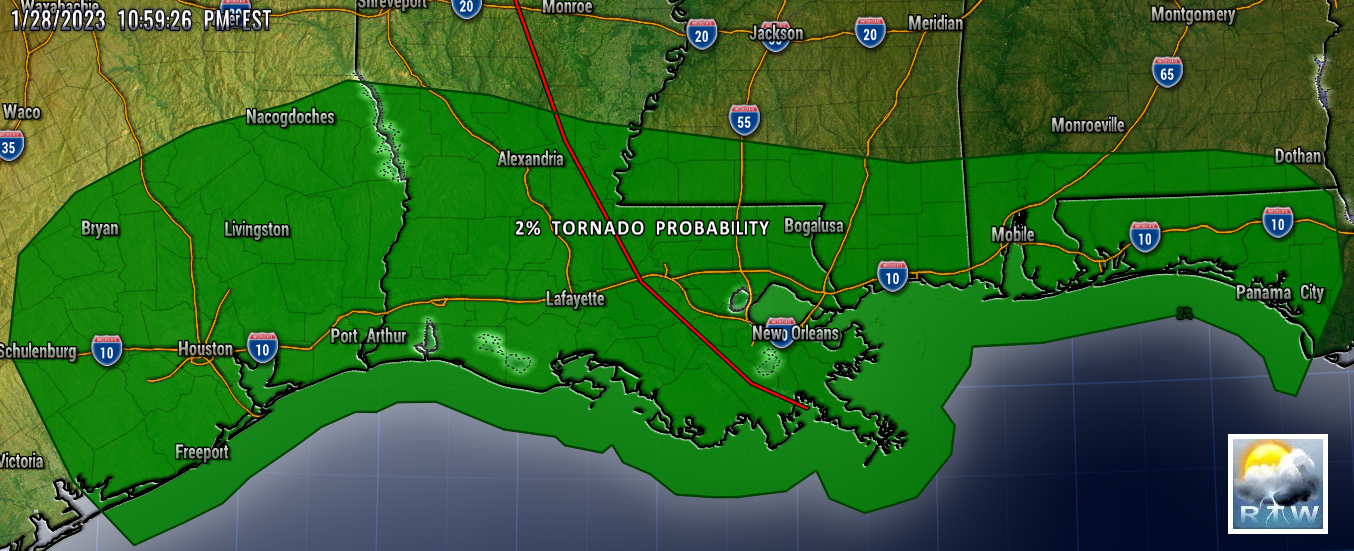
DAY 3 TORNADO PROBABILITY
5% RISK ...New Orleans, LA...Baton Rouge, LA...Mobile, AL...Tallahassee, FL...Metairie, LA...
WEATHER PREDICTION CENTER
DAY 2-3 EXCESSIVE RAINFALL OUTLOOK
WEATHER PREDICTION CENTER
NATIONAL FORECAST CHARTS
MESO DISCUSSION

Mesoscale Discussion 0118
   NWS Storm Prediction Center Norman OK
   0718 AM CST Tue Jan 31 2023

   Areas affected...southeastern Oklahoma and adjacent west-central and
   southwestern Arkansas...and southward to central Texas

   Concerning...Freezing rain

   Valid 311318Z - 311715Z

   SUMMARY...Freezing rain, falling at rates in excess of 0.05" per
   hour, can be expected this morning from central Texas northeastward
   across southeastern Oklahoma and adjacent portions of Arkansas.

   DISCUSSION...Latest surface analysis shows the cold front now over
   the western Gulf of Mexico, having cleared even deep South Texas.
   As a result, temperatures across much of the state -- with the
   exception of the Coastal Plain -- are near or below freezing.

   As the western U.S upper system (low centered over far northern Baja
   at this time) advances slowly eastward, a broad/leading plume of
   ascent -- evident in water vapor imagery across northern Mexico and
   the southern Plains, and arcing anticyclonically eastward across the
   Southeast -- is contributing to the development of convective
   precipitation across parts of central and northern Texas.

   This evolution is fairly well-handled by current CAM runs, which
   suggest the convection will continue to increase in coverage, and
   spread northeastward across southeastern Oklahoma with time, and
   eventually into parts of western Arkansas through late
   morning/midday.

   Morning RAOBs, and model point forecast soundings, reveal warm air
   aloft and weak instability, atop the sub-freezing boundary layer.
   This suggests potential for freezing rain, with rates in excess of
   0.05" per hour, including substantially greater rates over short
   intervals locally, as convective cells shift quickly northeastward.
   Freezing rain is being observed at this time across central and
   northern Texas with this developing precipitation, though parts of
   western North Texas and into south-central Oklahoma may also
   experience sleet, given the increasingly deep surface-based layer of
   sub-freezing air with northward extent.

   ..Goss.. 01/31/2023


.gif)

.gif)
.gif)
.gif)


