Wednesday, November 22, 2023

..SEVERE STORM OUTLOOK AND TROPICAL OUTLOOK COMBINED NOVEMBER 22, 2023..


Mesoscale Discussion 2285
   NWS Storm Prediction Center Norman OK
   0607 AM CST Wed Nov 22 2023

   Areas affected...Eastern North Carolina

   Concerning...Severe potential...Watch unlikely 

   Valid 221207Z - 221430Z

   Probability of Watch Issuance...20 percent

   SUMMARY...An isolated tornado threat is expected to develop across
   parts of eastern North Carolina this morning. The severe threat
   should remain marginal, and weather watch issuance is not expected.

   DISCUSSION...At mid-levels, a trough and an associated speed max,
   are located over the central Gulf Coast states. The 80 to 100 knot
   mid-level jet will continue to approach the Carolinas over the next
   few hours. As a result, large-scale ascent and deep-layer shear will
   gradually strengthen over the Carolinas this morning. At the
   surface, a mesoscale low is analyzed over northeastern South
   Carolina, with another in northeastern North Carolina. A weakly
   unstable airmass is present to the east of this surface trough. This
   airmass will slowly destabilize this morning, which will make
   conditions more favorable for rotating storms. In addition, the
   WSR-88D VWP near Wilmington, North Carolina currently has 0-3 km
   storm-relative helicity near 230 m2/s2. As the low-level shear
   strengthens ahead of the system, a marginal tornado threat is
   expected to develop. This threat should persist throughout the
   morning from near the coast of North Carolina inland about 50
   statute miles.

   ..Broyles/Edwards.. 11/22/2023

   ...Please see www.spc.noaa.gov for graphic product...

DAY 1 SEVERE STORM OUTLOOK

AREAS AT RISK
Categorical Day1 1300Z Outlook
 
Day 1 RiskArea (sq. mi.)Area Pop.Some Larger Population Centers in Risk Area
MARGINAL13,062958,094Wilmington, NC...Jacksonville, NC...New Bern, NC...Kinston, NC...Havelock, NC...


DAY 1 TORNADO PROBABILITY

AREAS AT RISK
Probability of a tornado within 25 miles of a point.
Hatched Area: 10% or greater probability of EF2 - EF5 tornadoes within 25 miles of a point. (More Info)
Day 1 Tornado RiskArea (sq. mi.)Area Pop.Some Larger Population Centers in Risk Area
2 %13,090959,966Wilmington, NC...Jacksonville, NC...New Bern, NC...Kinston, NC...Havelock, NC...


DAY 1 DAMAGING WIND PROBABILITY

AREAS AT RISK
Categorical Day1 1300Z Outlook
 
Day 1 RiskArea (sq. mi.)Area Pop.Some Larger Population Centers in Risk Area
MARGINAL13,062958,094Wilmington, NC...Jacksonville, NC...New Bern, NC...Kinston, NC...Havelock, NC...


000

ABNT20 KNHC 221148
TWOAT 

Tropical Weather Outlook
NWS National Hurricane Center Miami FL
700 AM EST Wed Nov 22 2023

For the North Atlantic...Caribbean Sea and the Gulf of Mexico:

Central Subtropical Atlantic:
An area of low pressure is expected to develop along a frontal 
boundary over the central subtropical Atlantic in a day or so. This 
non-tropical low is forecast to move southeastward across the 
central subtropical Atlantic over warmer sea surface temperatures 
during the next few days, and environmental conditions could allow 
for this system to gradually acquire tropical or subtropical 
characteristics. A subtropical or tropical storm could form by the 
latter part of this week or this weekend, as the system turns 
northeastward by the weekend.
* Formation chance through 48 hours...low...20 percent.
* Formation chance through 7 days...medium...50 percent.

$$
Forecaster Kelly


Tuesday, November 21, 2023

..SEVERE STORM OUTLOOK NOVEMEBER 21, 2023..


DAY-1 SEVERE WEATHER OUTLOOK


SEVERE STORM PROBABILITY AND AREAS AT RISK!
Categorical Day1 1300Z Outlook
 
Day 1 RiskArea (sq. mi.)Area Pop.Some Larger Population Centers in Risk Area
SLIGHT28,4452,506,916Montgomery, AL...Mobile, AL...Columbus, GA...Dothan, AL...Pensacola, FL...
MARGINAL142,83723,815,126Charlotte, NC...Virginia Beach, VA...Atlanta, GA...Raleigh, NC...Norfolk, VA...


DAY 1 TORNADO PROBABILITY 

TORNADO PROBABILITY AND AREAS AT RISK!
Probability of a tornado within 25 miles of a point.
Hatched Area: 10% or greater probability of EF2 - EF5 tornadoes within 25 miles of a point. (More Info)
Day 1 Tornado RiskArea (sq. mi.)Area Pop.Some Larger Population Centers in Risk Area
5 %28,3502,503,865Montgomery, AL...Mobile, AL...Columbus, GA...Dothan, AL...Pensacola, FL...
2 %129,09920,801,145Charlotte, NC...Virginia Beach, VA...Atlanta, GA...Raleigh, NC...Norfolk, VA...

DAY 1 DAMAGING WINDS PROBABILITY

DAMAGING WIND PROBABILITY AND AREAS AT RISK!
Probability of damaging thunderstorm winds or wind gusts of 50 knots or higher within 25 miles of a point.
Hatched Area: 10% or greater probability of wind gusts 65 knots or greater within 25 miles of a point. (More Info)
Day 1 Wind RiskArea (sq. mi.)Area Pop.Some Larger Population Centers in Risk Area
5 %171,20526,320,930Charlotte, NC...Virginia Beach, VA...Atlanta, GA...Raleigh, NC...Norfolk, VA...


Monday, November 20, 2023

..SEVERE WEATHER OUTLOOK NOVEMBER 20, 2023..


Visit Storm Prediction Center for the latest updates!

DAY 1 SEVERE STORM OUTLOOK


AREAS AT RISK FOR SEVERE STORMS
ENHANCED41,6372,380,912Shreveport, LA...Jackson, MS...Bossier City, LA...Monroe, LA...Hattiesburg, MS...
SLIGHT110,9178,017,294New Orleans, LA...Baton Rouge, LA...Mobile, AL...Metairie, LA...Mesquite, TX...
MARGINAL90,22615,765,609Houston, TX...Dallas, TX...Memphis, TN...Plano, TX...Birmingham, AL...


DAY 1 HAIL PROBABILITY

PROBABILITY OF HAIL AND AREAS AT RISK!
Probability of one inch diameter hail or larger within 25 miles of a point.
Hatched Area: 10% or greater probability of two inch diameter hail or larger within 25 miles of a point. (More Info)
Day 1 Hail RiskArea (sq. mi.)Area Pop.Some Larger Population Centers in Risk Area
15 %73,9843,966,466Shreveport, LA...Mesquite, TX...Tyler, TX...College Station, TX...Longview, TX...
5 %72,81712,988,651Houston, TX...Dallas, TX...Plano, TX...Baton Rouge, LA...Garland, TX...


DAY 1 TORNADO PROBABILITY

TORNADO PROBABILITY AND AREAS AT RISK!
Probability of a tornado within 25 miles of a point.
Hatched Area: 10% or greater probability of EF2 - EF5 tornadoes within 25 miles of a point. (More Info)
Day 1 Tornado RiskArea (sq. mi.)Area Pop.Some Larger Population Centers in Risk Area
SIG SEVERE41,4392,376,378Shreveport, LA...Jackson, MS...Bossier City, LA...Monroe, LA...Hattiesburg, MS...
10 %41,5582,376,992Shreveport, LA...Jackson, MS...Bossier City, LA...Monroe, LA...Hattiesburg, MS...
5 %104,7767,318,002New Orleans, LA...Baton Rouge, LA...Mobile, AL...Metairie, LA...Lafayette, LA...
2 %84,72912,420,662Houston, TX...Memphis, TN...Birmingham, AL...Montgomery, AL...Little Rock, AR...


DAY 1 DAMAGING WIND PROBABILITY!

DAMAGING WIND PROBABILITY AND AREAS AT RISK!
Probability of damaging thunderstorm winds or wind gusts of 50 knots or higher within 25 miles of a point.
Hatched Area: 10% or greater probability of wind gusts 65 knots or greater within 25 miles of a point. (More Info)
Day 1 Wind RiskArea (sq. mi.)Area Pop.Some Larger Population Centers in Risk Area
30 %24,9051,418,037Jackson, MS...Monroe, LA...Hattiesburg, MS...Vicksburg, MS...Clinton, MS...
15 %121,8838,417,755New Orleans, LA...Baton Rouge, LA...Shreveport, LA...Mobile, AL...Metairie, LA...
5 %95,98316,224,445Houston, TX...Dallas, TX...Memphis, TN...Plano, TX...Birmingham, AL...


..TROPICAL OUTLOOK NOVEMBER 20, 2023..


The National Hurricane Center is monitoring to low formation chance storm investigations.  One is in the east Caribbean and the other in the north Atlantic.  No threat to the U.S. mainland!

Heavy rains from this weekend have moved over Puerto Rico.  There is no training of these cells observed over the Island, but some flooding could occur as these slow moving showers track across the island.

RTW

ZCZC MIATWOAT ALL
TTAA00 KNHC DDHHMM

Tropical Weather Outlook
NWS National Hurricane Center Miami FL
700 AM EST Mon Nov 20 2023

For the North Atlantic...Caribbean Sea and the Gulf of Mexico:

1. Central Caribbean Sea:
Shower and thunderstorm activity has increased somewhat in 
association with a small area of low pressure located over the 
central Caribbean Sea. However, environmental dry air is still 
likely to prevent significant development of this system as it 
begins to drift slowly westward later this week.
* Formation chance through 48 hours...low...10 percent.
* Formation chance through 7 days...low...10 percent.

2. Central Subtropical Atlantic:
A non-tropical area of low pressure is forecast to develop along a 
front over the central portion of the Atlantic basin during the next 
couple of days. Thereafter, environmental conditions appear somewhat 
conducive for this system to gradually acquire some subtropical or 
tropical characteristics during the latter part of this week while 
it moves generally eastward across the central subtropical Atlantic.
* Formation chance through 48 hours...low...near 0 percent.
* Formation chance through 7 days...low...30 percent.

Forecaster Papin


Friday, November 17, 2023

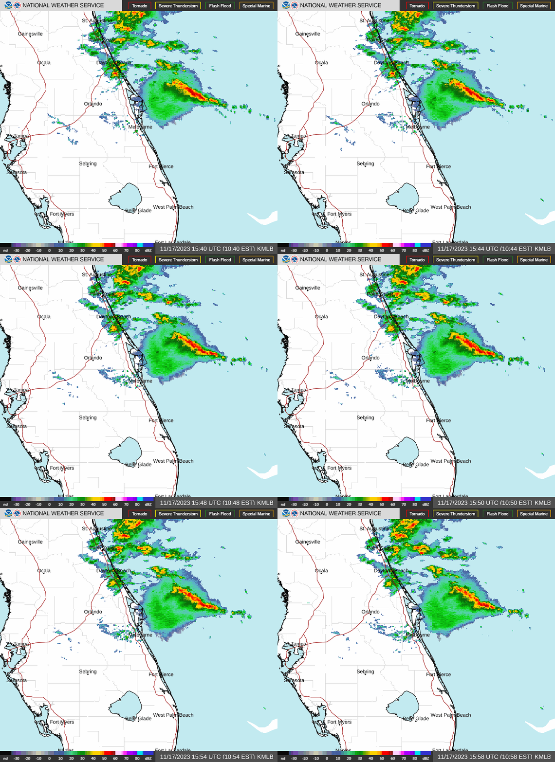
..Mesoscale Precipitation Discussion 1178..


Mesoscale Precipitation Discussion 1178
NWS Weather Prediction Center College Park MD
353 AM EST Fri Nov 17 2023

Areas affected...east-central to northeastern FL Peninsula

Concerning...Heavy rainfall...Flash flooding possible

Valid 170850Z - 171445Z

SUMMARY...A flash flood threat will linger across portions of the
east-central to northeastern FL Peninsula into mid-morning,
although the coverage/probabilities of high rainfall rates appear
to be lower than earlier in the night. Highly localized rainfall
rates over 3 in/hr will remain possible through 14Z.

DISCUSSION...3.9 micron satellite imagery and 08Z surface
observations showed a surface low located ~40 miles NNW of western
Grand Bahama Island, moving toward the northwest into the greatest
pressure tendency falls. Meanwhile, a 1006 mb mesoscale low had
formed over Indian River County, west of Vero Beach, along a
south-north oriented coastal boundary that pushed inland, located
just west of ISM and northward across St. Johns County at 08Z.
Infrared satellite imagery showed that the elevated reflection of
this inland low near the coast has drifted 10-20 miles offshore of
Indian River County along with the heaviest rain associated with
the low. Farther inland, slow moving cells with relatively warm
cloud tops were located over western Osceola County with earlier
MRMS-derived rainfall rates over 4 in/hr locally, but with recent
decreased rainfall intensities.

While trends in radar imagery over the past 1-2 hours have shown
oscillations in rainfall intensity with rainfall in and around
east-central FL and cell organization has waned somewhat since
06Z, a localized threat for heavy rain will continue through
mid-morning. A localized flash flood threat near the mesolow just
offshore of Indian River County will exist should the low
translate back toward the coast, although the future persistence
of this feature is uncertain.

Otherwise, the synoptic scale low NNW of western Grand Bahama
Island is forecast to follow a northwestward motion toward the
east-central FL coast through 14Z, with the strongest (20-30 kt
925-850 mb winds) focusing from near Cape Canaveral to St. Johns
County. low level convergence at the nose of these easterly winds
will continue a threat for slow moving cells capable of rainfall
rates locally over 3 in/hr near and east of the north-south
convergence axis. However, effective bulk shear values are
forecast to decrease through the remainder of the morning which
should limit cell organization.

Therefore, while the coverage and probabilities of high (2 to 3+
in/hr) rainfall rates appears to decrease over the next 3-6 hours,
a localized flash flood threat will remain across portions of the
east-central to northeastern FL Peninsula into the mid-morning
hours.

Otto


..POTENTIAL TROPICAL CYCLONE TWO UPDATE NOVEMBER 17, 2023..


...DISTURBANCE'S CHANCE OF BECOMING A TROPICAL CYCLONE IS DECREASING... ...BUT HEAVY RAINFALL AND FLOODING WILL CONTINUE TO BE A THREAT ACROSS JAMAICA, EASTERN CUBA, AND HAITI...
10:00 AM EST Fri Nov 17
Location: 17.5°N 79.1°W
Moving: NE at 14 mph
Min pressure: 1004 mb
Max sustained: 35 mph