Wednesday, May 15, 2024

..TROPICAL WEATHER OUTLOOK MAY 15, 2024..


Today commences the beginning of the East Pacific Hurricane Season, and the NHC begins the tropical weather outlook and monitors waves coming off the coast of Africa. I also began to monitor here as well, and so far there are no signs of development in the Atlantic Ocean and the Gulf of Mexico.

Sea surface temperatures across the Atlantic continue to warm, which would be fuel for tropical cyclone formation in the coming months.


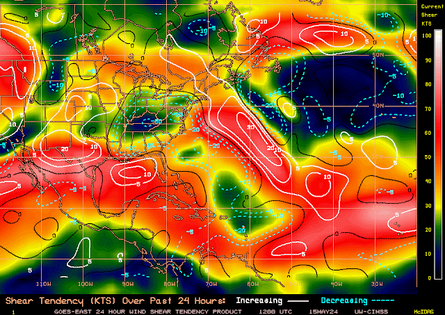
At this time, upper-level winds are not favorable for development.
Green: FAVORABLE/ Yellow: NEUTRAL/ Red: UNFAVORABLE

White Increasing shear/ Blue Decreasing shear


Water vapor imagery in the upper level shows plenty of moisture across the Atlantic basin, except for a small area between 65 degrees west and 50 degrees west and 20 degrees north to 16 degrees north. So at the upper levels, it is favorable, except we need all levels of the atmosphere to have equal amounts of moisture. Mid-levels are a bit drier, and lower-levels are even drier. So it is not favorable for development at this time.
Upper Level Moisture (plenty of moisture)


Mid Level Moisture (Less Favorable)

Lower level Moisture (Even drier Not Favorable)


You can see in this model that some of the dry air is being replaced by blues and greens, which is precipitation.

There's not much going on with the EURO Ensemble model.

There is a bit more going on with the GEFS Ensemble, including a low tracking north from the Caribbean and across eastern Cuba, then tracking west over the northern coast of Cuba and looping back over Central Cuba, then tracking north between Florida and the West Bahamas. Nothing significant, though!

There is not much going on with this Euro in this ensemble as well.

This ensemble shows a stronger low passing over Haiti.

This is the GEFS ensemble, and it also shows the small, low tracking north between the east Florida coast and the western Bahamas. 

There are no tropical wave symbols in the Atlantic at this time. All remains quiet for now.


Monday, May 6, 2024

..SEVERE STORM OUTLOOK FOR MONDAY MAY 6, 2024 ENHANCED, MODERATE, HIGH, AND A SIGNIFICANT RISK.. ..BE READY FOR A DANGEROUS WEATHER DAY!..


Another wicked round of large destructive tornado in the Oklahoma and portion of Kansas today.  Enhanced, Moderate, High, Significant risk for large tornado, large damaging hail and damaging winds expected in the risk areas.  Stay alert and take cover when warnings are issued.

Stay tuned to local media, NOAA weather radio and the Storm Prediction Center for the latest updates.

RTW

Areas at risk for severe weather:

HIGH20,2181,682,330Oklahoma City, OK...Norman, OK...Edmond, OK...Midwest City, OK...Moore, OK...
MODERATE34,8292,195,816Tulsa, OK...Wichita, KS...Lawton, OK...Broken Arrow, OK...Hutchinson, KS...
ENHANCED96,0675,714,989Kansas City, MO...Lincoln, NE...Overland Park, KS...Springfield, MO...Kansas City, KS...
SLIGHT182,2528,024,584Omaha, NE...Des Moines, IA...Wichita Falls, TX...Denton, TX...Lewisville, TX...
MARGINAL220,35613,834,380Dallas, TX...Fort Worth, TX...Arlington, TX...St. Louis, MO...Plano, TX...


Areas at risk for large destructive tornado:

Probability of a tornado within 25 miles of a point.
Hatched Area: 10% or greater probability of EF2 - EF5 tornadoes within 25 miles of a point.

SIG SEVERE98,7645,352,361Oklahoma City, OK...Tulsa, OK...Wichita, KS...Topeka, KS...Norman, OK...
30 %20,3721,689,242Oklahoma City, OK...Norman, OK...Edmond, OK...Midwest City, OK...Moore, OK...
15 %34,6832,185,547Tulsa, OK...Wichita, KS...Lawton, OK...Broken Arrow, OK...Hutchinson, KS...
10 %77,0545,121,950Kansas City, MO...Overland Park, KS...Springfield, MO...Kansas City, KS...Topeka, KS...
5 %108,1225,015,697Omaha, NE...Lincoln, NE...Des Moines, IA...Denton, TX...Columbia, MO...
2 %185,99012,309,498Dallas, TX...Fort Worth, TX...Arlington, TX...St. Louis, MO...Plano, TX...


Areas at risk for large destructive hail:

Probability of one inch diameter hail or larger within 25 miles of a point.
Hatched Area: 10% or greater probability of two inch diameter hail or larger within 25 miles of a point.

SIG SEVERE131,9814,848,193Oklahoma City, OK...Tulsa, OK...Wichita, KS...Norman, OK...Wichita Falls, TX...
45 %32,4952,473,511Oklahoma City, OK...Wichita, KS...Norman, OK...Lawton, OK...Edmond, OK...
30 %50,047946,822Wichita Falls, TX...Salina, KS...Grand Island, NE...Shawnee, OK...Kearney, NE...
15 %124,9914,818,362Omaha, NE...Tulsa, OK...Lincoln, NE...Topeka, KS...Denton, TX...
5 %156,16010,733,767Dallas, TX...Fort Worth, TX...Kansas City, MO...Arlington, TX...Plano, TX...


Areas at risk for damaging winds:

Probability of damaging thunderstorm winds or wind gusts of 50 knots or higher within 25 miles of a point. Hatched Area: 10% or greater probability of wind gusts 65 knots or greater within 25 miles of a point.

SIG SEVERE75,2156,164,181Kansas City, MO...Tulsa, OK...Wichita, KS...Lincoln, NE...Overland Park, KS...
30 %124,9909,224,513Oklahoma City, OK...Kansas City, MO...Tulsa, OK...Wichita, KS...Lincoln, NE...
15 %190,1738,159,562Omaha, NE...Des Moines, IA...Wichita Falls, TX...Denton, TX...Lewisville, TX...
5 %239,25614,099,154Dallas, TX...Fort Worth, TX...Arlington, TX...St. Louis, MO...Plano, TX...


Square profile picture
1045am - we just did a briefing for close to 400 of our emergency management and television partners. We thought it would be good to share some of the key point we discussed with them. #okwx #texomawx


Wednesday, April 24, 2024

..THE 2024 HURRICANE SEASON IS RAPIDLY APPROACHING AND ITS FORECAST TO BE A VERY BUSY SEASON... ...ARE YOU STORM READY?...


 HURRICANE KIT

  • Flashlights & extra bulbs or (LED Flashlight)
  • Battery-operated radio
  • Battery-operated lanterns
  • Batteries (in different sizes!)  
  • Matches 
  • First aid kit
  • Duct tape
  • Rain gear
  • Clock (wind-up or battery-powered)
  • Plastic garbage bags
  • Fire extinguisher
  • Scissors
  • Can Opener
  • Clean clothes
  • Extra blankets
  • Heavy gloves

FOOD NEEDS

Pack food and water for each person for 3-7 days.

  • Bottled water (1 gallon/person/day) 
  • Bottled drinks
  • Non-perishable food and snacks
  • Food that can easily be stored in a cooler
  • A manual can opener
PREPARE YOUR PET
  • Water for your pet for 3-7 days  
  • Non-perishable food
  • Crate/carrier/tank
  • Leash (non-extendable)
  • Collar and/or harness
  • Favorite Toy
  • Blanket or pillow
  • Clean litter box for cats
  • Updated shots and medical records
  • Microchip with up-to-date content info
  • Any medications
  • Calming aids
  • Tags
  • Puppy training pads
  • Hear tworm preventatives
  • Rain gear 
MEDICAL NEEDS
  • Medic-alert tags
  • Insect-repellent sprays
  • Feminine hygiene items
  • Sunscreen
  • Soap
  • First aid kit
  • Prescription medication

  • Over-the-counter medication
  • Children's medicine
  • Bandages
  • Adhesive tape
  • Antiseptic solution
  • Thermometer
  • Tweezers
  • PREPARE YOUR HOUSE
    • Remove outdoor items
    • Trim dead branches from trees
    • Board up windows
    • Fill gas tanks and extra containers
    • Get extra cash
    • Move furniture away from windows
    • Store important documents in waterproof containers
    • Extra supply of medicines

     EMERGENCY COMMUNICATION

    • GMRS Radios FCC GMRS License Required (General Mobile Radio Service)
    • FRS (Radio Family Radio Service) No FCC License Required from Channel 8-14
    • CB radio (Citizen Band Radio) No FCC license required

    These radios are good to have when cell phone towers are down or overloaded.  In disasters such as tornado, hurricane winter storms cell phone towers and power can be disrupted.  So the air waves is the way to go.

    These radios can use your car battery or if you have a portable battery backup with lighter or A/C receptacles you can easily charge your GMRS handy talkie batteries in their specified charger.  Below are some radios for mobile and on the go.

    Longer talking distance on a repeater or shorter distance without.  These radios work with line of site so depending where you live if there are tall buildings it could disrupt transmission signal.  However, If the repeater you are using is on top of a tall building then you should reach the repeater as long as you are within the repeaters range.  How you check if your within range of repeater; simply press and hold the (PTT) push to talk button on the side of the handheld radio or microphone for 2 second; release and if you hear a hissing sound and a ka-chunk sound at end of the transmission; this means you broke the squelch of the repeater and are close enough to transmit.  However, there are times that you hear the ka-chunk but you may be outside of the repeaters range and your modulation will not be heard. When you key up and release and all sounds clear followed by the ka-chunk this means you are within the repeater range so you can transmit and modulate with no problems.

    If you live in Miami-Dade and Broward and have your FCC GMRS (General Mobile Radio Service) license you can join the South Dade GMRS Radio Club so you can be ready for a disaster in your area. Click below to learn more.

    www.southdadegmrs.com

    HT (4-5watt) Handy Talkie   

    GMRS FCC LICENSE REQUIRED!

    Car Mobile Radio 25-50watts ( longer distance talk)

    GMRS FCC LICENSE REQUIRED!

    (Requires a mobile radio antenna with frequency range for your radio preferably pre-tuned)

    FRS Radios (Family Radio Service)  

    NOT REPEATER CAPABLE! 

    (No FCC license required for channels 8-14.  Short distance talk on these channels)

    How to apply for GMRS license (https://youtu.be/t2XnY0iC_ug)

    GMRS are Repeater Capable radios meaning they can be programmed to be used on your own repeater or another owners repeater with their permission.  MyGMRS.com has a list of repeater owned by others that at times are open to the public.  

    You need to apply for the a GMRS FCC license before you can register with myGMRS.com.  It takes 24 hours for your license to show in their data base.  

    After that you simply register and go to repeaters and check for repeaters near you.  You look for those that say open and then via your radio software you program the Receive and Transmit frequencies. Then the Receive and Transmit PL Tone or CTCSS which ranges from 67.0 to 250.3.  These are privacy codes repeaters owners set on their repeater so it makes the repeater private only to those permitted to use the repeater.

    Please note that in an disaster FCC does not require the use of a radio License to transmit on a radio.

    § 97.403 Safety of life and protection of property.

    No provision of these rules prevents the use by an amateur station of any means of radio communication at its disposal to provide essential communication needs in connection with the immediate safety of human life and immediate protection of property when normal communication systems are not available.


    RALPH'S TROPICAL WEATHER-RTW


    Thursday, April 11, 2024

    ..SLIGHT RISK FOR SEVERE STORMS FOR A PORTION OF NORTHERN AND CENTRAL FLORIDA..


    PLENTY OF LIGHTNING WITH THIS LINE OF STORMS MOVING IN OVER FLORIDA THIS MORNING AND AFTERNOON.  STAY TUNED TO THE STORM PREDICTION CENTER FOR THE LATEST SEVERE STORM OUTLOOK UPDATES.

    RTW

    SEVERE STORM OUTLOOK (SLIGHT RISK)


    ENHANCED18,7192,690,772Canton, OH...Charleston, WV...Huntington, WV...Parkersburg, WV...Massillon, OH...
    SLIGHT104,81823,480,375Jacksonville, FL...Columbus, OH...Cleveland, OH...Tampa, FL...Pittsburgh, PA...
    MARGINAL230,27041,233,248Baltimore, MD...Charlotte, NC...Washington, DC...Virginia Beach, VA...Raleigh, NC...

    TORNADO OUTLOOK

    Probability of a tornado within 25 miles of a point.
    Hatched Area: 10% or greater probability of EF2 - EF5 tornadoes within 25 miles of a point.
    10 %18,8122,696,044Canton, OH...Charleston, WV...Huntington, WV...Parkersburg, WV...Massillon, OH...
    5 %70,43014,676,227Jacksonville, FL...Tampa, FL...Pittsburgh, PA...St. Petersburg, FL...Akron, OH...
    2 %226,61044,018,581Columbus, OH...Baltimore, MD...Charlotte, NC...Washington, DC...Cleveland, OH...

    DAMAGING WIND OUTLOOK

    Probability of damaging thunderstorm winds or wind gusts of 50 knots or higher within 25 miles of a point.
    Hatched Area: 10% or greater probability of wind gusts 65 knots or greater within 25 miles of a point.
    15 %123,48826,115,994Jacksonville, FL...Columbus, OH...Cleveland, OH...Tampa, FL...Pittsburgh, PA...
    5 %230,27741,284,292Baltimore, MD...Charlotte, NC...Washington, DC...Virginia Beach, VA...Raleigh, NC...

    DAMAGING HAIL OUTLOOK (FLORIDA NOT INCLUDED)

    Probability of one inch diameter hail or larger within 25 miles of a point.
    Hatched Area: 10% or greater probability of two inch diameter hail or larger within 25 miles of a point.
    5 %79,87016,438,875Columbus, OH...Cleveland, OH...Pittsburgh, PA...Cincinnati, OH...Lexington-Fayette, KY...


    EXCESSIVE RAINFALL OUTLOOK


    TORNADO WATCH OUTLOOK


    URGENT - IMMEDIATE BROADCAST REQUESTED
       Tornado Watch Number 104
       NWS Storm Prediction Center Norman OK
       730 AM EDT Thu Apr 11 2024
    
       The NWS Storm Prediction Center has issued a
    
       * Tornado Watch for portions of 
         North and Central Florida
         Southern Georgia
         Coastal Waters
    
       * Effective this Thursday morning and afternoon from 730 AM until
         300 PM EDT.
    
       * Primary threats include...
         A couple tornadoes possible
         Scattered damaging wind gusts to 70 mph possible
    
       SUMMARY...A pre-frontal broken band of storms will gradually shift
       east across the watch area through the morning and into the early
       afternoon.  A few supercells and line segments will probably pose
       some risk for a few tornadoes and damaging gusts.
    
       The tornado watch area is approximately along and 75 statute miles
       east and west of a line from 15 miles west northwest of Brunswick GA
       to 20 miles south southwest of Saint Petersburg FL. For a complete
       depiction of the watch see the associated watch outline update
       (WOUS64 KWNS WOU4).
    
       PRECAUTIONARY/PREPAREDNESS ACTIONS...
    
       REMEMBER...A Tornado Watch means conditions are favorable for
       tornadoes and severe thunderstorms in and close to the watch
       area. Persons in these areas should be on the lookout for
       threatening weather conditions and listen for later statements
       and possible warnings.
    
       &&
    
       AVIATION...Tornadoes and a few severe thunderstorms with hail
       surface and aloft to 1 inch. Extreme turbulence and surface wind
       gusts to 60 knots. A few cumulonimbi with maximum tops to 500. Mean
       storm motion vector 23035.
    
       ...Smith