
RTW


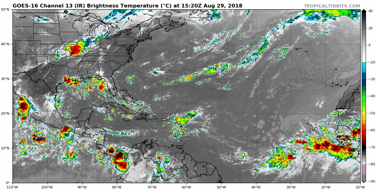
761
AXNT20 KNHC 291750
TWDAT

Tropical Weather Discussion
NWS National Hurricane Center Miami FL
150 PM EDT Wed Aug 29 2018

Tropical Weather Discussion for North America, Central America
Gulf of Mexico, Caribbean Sea, northern sections of South
America, and Atlantic Ocean to the African coast from the
Equator to 32N. The following information is based on satellite
imagery, weather observations, radar and meteorological analysis.

Based on 1200 UTC surface analysis and satellite imagery through
1730 UTC.

...TROPICAL WAVES...

An Atlantic Ocean tropical wave is along 31W/32W from 15N
southward. A 1013 mb low pressure center is along the wave near
09N. scattered moderate to widely scattered strong rainshowers
are from 08N to 13N between Africa and 29W. Isolated moderate to
locally strong rainshowers are elsewhere from 07N to 17N between
Africa and 31W.

An Atlantic Ocean-to-Caribbean Sea tropical wave is along 21N58W
16N60W 13N62W 08N62W, ending in Venezuela. Widely scattered
moderate to isolated strong rainshowers from 13N to 20N between
58W and Puerto Rico. Isolated moderate to locally strong
rainshowers are elsewhere from the SE corner of the Caribbean Sea
to 23N in the Atlantic Ocean between 54W and 70W.

A Caribbean Sea tropical wave is along 86W/87W from 22N in the
Yucatan Channel, beyond Central America, into the eastern Pacific
Ocean. Isolated moderate rainshowers are from 18N northward from
the Windward Passage westward.

...MONSOON TROUGH/ITCZ...

The monsoon trough passes through the coastal sections of Senegal
near 16N17W, to 11N25W, to the 1013 mb low pressure center that is
along the 31W/32W tropical wave, 08N38W. The ITCZ continues from
08N38W to 08N49W. widely scattered moderate to isolated strong
rainshowers are from 03N to 10N between 28W and 40W. isolated
moderate rainshowers are elsewhere from 10N southward, mainly
between 40W and 60W.

...DISCUSSION...

GULF OF MEXICO...

A surface trough extends from central Louisiana, to the upper
Texas Gulf coast, to inland south central Texas. Scattered
moderate to isolated/widely scattered strong rainshowers are to
the north of the line from 25N90W to 28N96W from 90W westward.

The upper level inverted trough/cyclonic circulation center from
24 hours ago has moved into Mexico, and now it is along 100W.
Isolated moderate rainshowers are to the west of the line that
runs from 26N95W to 19N92W.

Weak upper level cyclonic wind flow is in the eastern one-third of
the Gulf of Mexico. Widely scattered moderate to isolated strong
rainshowers are from 25N northward from 90W eastward. Isolated
moderate rainshowers are elsewhere from 22N northward in the Gulf
of Mexico.

A weak ridge will dominate the Gulf waters into the weekend and
support gentle to moderate winds. A surface trough will develop
each evening over the Yucatan Peninsula before moving W and
offshore into the SW Gulf overnight. A surge of moderate to fresh
NE to E winds will accompany this trough.

CARIBBEAN SEA...

An upper level east-to-west oriented trough is along 15N/16N from
70W westward to Central America. Upper level cyclonic wind flow
covers the Caribbean Sea from 14N northward from 70W westward.
Isolated moderate rainshowers are in the area of upper level
cyclonic wind flow.

Broad upper level cyclonic wind flow, from a trough, spans the
Caribbean Sea between 60W and 70W. The trough extends from the
Atlantic Ocean, across Puerto Rico to Venezuela. isolated moderate
rainshowers cover the rest of that part of the Caribbean Sea that
is between 60W and 70W. A tropical wave is in the easternmost part
of the Caribbean Sea, with its associated precipitation.

The eastern part of the eastern Pacific monsoon trough is along
09N from 74W in Colombia beyond southern Costa Rica. An upper
level trough extends from southern Nicaragua to Panama. scattered
moderate to strong rainshowers are from 11N southward from 80W and
83W.

Fresh to strong winds will prevail in the south central Caribbean
Sea today, before diminishing from tonight through Saturday.
Gentle to moderate winds will prevail elsewhere.

ATLANTIC OCEAN...

Upper level cyclonic wind flow, with an inverted trough, covers
the Atlantic Ocean from 20N northward from 70W westward. isolated
moderate rainshowers are in the area of cyclonic wind flow.

An upper level trough extends from a 32N40W cyclonic circulation
center, to a second cyclonic circulation center that is near
28N46W, to a third 24N63W cyclonic circulation center, toward the
Windward Passage. Isolated moderate rainshowers are to the NW of
the line that passes through 32N38W to 25N47W to 23N60W to the
Mona Passage.

Surface high pressure will remain centered SW of Bermuda through
the forecast period. Moderate to fresh winds will be S of 24N,
and gentle to moderate winds will be N of 24N. Winds will pulse
to fresh to strong just N of Hispaniola, including the approach
to the Windward Passage, during the evening and overnight hours
through Sunday. A tropical wave moving into the NE Caribbean Sea
and the adjacent Atlantic Ocean today, will produce active
weather as it moves westward across the Lesser Antilles and
Bahamas through Monday.

For additional information please visit
http://www.hurricanes.gov/marine

$$
MT
https://www.nhc.noaa.gov/
----------------------------------------------------------------
Storm Investigation
011
ABNT20 KNHC 291743
TWOAT

Tropical Weather Outlook
NWS National Hurricane Center Miami FL
200 PM EDT Wed Aug 29 2018

For the North Atlantic...Caribbean Sea and the Gulf of Mexico:

A vigorous low pressure area associated with a tropical wave is
forecast to form between the coast of Africa and the Cabo Verde
Islands on Thursday. Conditions appears to be favorable for
development, and a tropical depression could form over the weekend
while the system moves west-northwestward near the Cabo Verde
Islands and the adjacent Atlantic.  This system is expected to bring
rains and gusty winds to those islands in two or three days, and
interests in that region should monitor the progress of this
disturbance.
* Formation chance through 48 hours...low...30 percent.
* Formation chance through 5 days...medium...60 percent.

$$
Forecaster Avila
-----------------------------------------------------------------
African wave has a higher chance for tropical formation but should
stay out over the North Atlantic waters. The system that is forecast
to develop over the Bahamas not very many models other the than the
ECMWF is suggesting development and a track across Florida. I will
continue to monitor but development is still questionable.
Are you Hurricane Ready? RTW

687
AXNT20 KNHC 291205
TWDAT

Tropical Weather Discussion
NWS National Hurricane Center Miami FL
805 AM EDT Wed Aug 29 2018

Tropical Weather Discussion for North America, Central America
Gulf of Mexico, Caribbean Sea, northern sections of South
America, and Atlantic Ocean to the African coast from the
Equator to 32N. The following information is based on satellite
imagery, weather observations, radar and meteorological analysis.

Based on 0600 UTC surface analysis and satellite imagery through
1115 UTC.

...TROPICAL WAVES...

A tropical wave is over the east Atlantic with axis along 32W
between 03N-14N, moving west at 10-15 kt. A 1012 mb low is
embedded on the wave axis near 08N32W. Scattered moderate
convection is from 04N-10N between 29W-36W.

An Atlantic Ocean tropical wave extends it axis from 20N57W to
07N61W, moving west at 10-15 kt. Widely scattered moderate
convection is over the northern portion of the wave from 13N-20N
between 54W-64W, over the Leeward Islands.

A tropical wave is moving across the west Caribbean with axis
along 86W between 03N-21N, moving west at 10-15 kt. Isolated
moderate convection is over the NW Caribbean and Central America.

...MONSOON TROUGH/ITCZ...

The monsoon trough passes through the coastal sections of Senegal
near 15N17W to 09N26W to a 1012 mb low near 08N32W to 08N39W. The
ITCZ continues from that point to 06N45W to 08N51W. Aside from
the convection related to the tropical waves, scattered moderate
to isolated strong convection is alongthe coast of W Africa from
08N-14N. Isolated moderate convection is from 06N-10N between
42W-48W.

...DISCUSSION...

GULF OF MEXICO...

An upper-level low is in the NE corner of Mexico near 26N100W.
Cyclonic flow covers Texas and N Mexico and the W Gulf of Mexico
N of 20N and W of 94W. Isolated moderate convection is over the
area. Another small upper level low is centered over the NE Gulf
near 30N88W. Scattered showers are over the E Gulf, Florida, and W
Cuba. At the surface, a ridge prevails across the basin along 30N
with 10 kt SE return flow.

A surface trough will develop each night over the Yucatan
Peninsula, then push offshore into the Bay of Campeche with
convection. A surge of moderate to fresh NE to E winds will
accompany this trough. A surface ridge will continue to dominate
the reminder of the Gulf waters, supporting gentle to moderate
winds.

CARIBBEAN SEA...

A tropical wave is moving across the west Caribbean, and another
tropical wave has entered the E Caribbean. Refer to the section
above for details. An upper level low is centered over Jamaica
near 18N77W. This feature is producing isolated moderate
convection over Jamaica and E Cuba. Elsewhere, scattered moderate
to strong convection is over the SW Caribbean S of 10N to include
N Colombia, Panama, and Costa Rica.

Fresh to strong winds will develop each night in the south
central Caribbean Sea just north of Colombia. Gentle to moderate
winds will prevail elsewhere.

ATLANTIC OCEAN...

A tropical wave with an embedded low is moving across the basin.
Refer to the section above for details. An upper-level low is
centered over the central Atlantic near 26N60W. Scattered showers
are within 300 nm of the center. On the surface, a trough is over
the W Atlantic from 30N80W to 25N80W. Scattered showers are noted
within 120 nm of the trough. A 1022 mb high is over the W Atlantic
near 29N67W. To the east, another 1025 mb high is centered near
37N22W.

Surface ridging will prevail through the forecast period. Expect
moderate to fresh winds S of 24N, and gentle to moderate winds N
of 24N. The wind speeds will pulse to fresh to strong just N of
Hispaniola at night through the weekend.

For additional information please visit
http://www.hurricanes.gov/marine

$$
Formosa
https://www.nhc.noaa.gov/
-----------------------------------------------------------------
Storm Investigation
107
ABNT20 KNHC 291129
TWOAT

Tropical Weather Outlook
NWS National Hurricane Center Miami FL
800 AM EDT Wed Aug 29 2018

For the North Atlantic...Caribbean Sea and the Gulf of Mexico:

A low pressure area is forecast to form between the coast of Africa
and the Cabo Verde Islands in association with a tropical wave that
is expected to move off the west coast of Africa late Thursday or
early Friday.  Additional development is anticipated, and a tropical
depression could form over the weekend while the system moves
west-northwestward near the Cabo Verde Islands. Interests in those
islands should monitor the progress of this system.
* Formation chance through 48 hours...low...10 percent.
* Formation chance through 5 days...medium...50 percent.

$$
Forecaster Avila
-------------------------------------------------------------------
Still monitoring the African coast for waves with potential for
development. Also off east of Florida since the EURO model still
suggesting development over the Bahamas...RTW


194
AXNT20 KNHC 281655
TWDAT

Tropical Weather Discussion
NWS National Hurricane Center Miami FL
1255 PM EDT Tue Aug 28 2018

Tropical Weather Discussion for North America, Central America
Gulf of Mexico, Caribbean Sea, northern sections of South
America, and Atlantic Ocean to the African coast from the
Equator to 32N. The following information is based on satellite
imagery, weather observations, radar and meteorological analysis.

Based on 1200 UTC surface analysis and satellite imagery through
1630 UTC.

...TROPICAL WAVES...

An Atlantic Ocean tropical wave is along 19W/20W from 20N
southward. Isolated moderate rainshowers are from 05N to 19N
between Africa and 23W.

An Atlantic Ocean tropical wave is along 26W/27W from 20N
southward. Widely scattered moderate to isolated strong
rainshowers are from 07N to 12N between 26W and 30W. Isolated
moderate to locally strong rainshowers are elsewhere from 04N to
13N between 20W and 30W. Rainshowers are possible in the remainder
of the area from 19N southward from 44W eastward.

An Atlantic Ocean tropical wave is along 52W/53W from 20N
southward. Isolated moderate rainshowers are from 10N to 20N
between 43W and 60W.

A Caribbean Sea tropical wave is along 68W/69W from 21N
southward, through the Mona Passage/eastern sections of the
Dominican Republic to Venezuela. Upper level cyclonic wind flow
covers the Atlantic Ocean from 20N to 27N between 60W and 70W.
Isolated moderate rainshowers are from 16N to 26N between 60W and
70W.

A tropical wave is along 88W/89W from 22N southward, from the
Yucatan Peninsula through Belize, Guatemala, and El Salvador, into
the eastern Pacific Ocean. Isolated moderate rainshowers are
within 90 nm on either side of the tropical wave.

...MONSOON TROUGH/ITCZ...

The monsoon trough passes through the coastal sections of Senegal
near 14N17W, to 10N24W, 08N32W, and 09N41W. The ITCZ is not
discernible. Isolated moderate to locally strong rainshowers are
cover the area from 04N to 13N between 20W and 30W. Isolated
moderate rainshowers cover the rest of the area from 19N
southward from 60W eastward.

...DISCUSSION...

GULF OF MEXICO...

An upper level inverted trough is in the N central part of the
Gulf of Mexico. Cyclonic wind flow covers the NE corner of the
area. isolated moderate rainshowers are from 90W eastward.

An upper level cyclonic circulation center is in the NE corner of
Mexico. Cyclonic wind flow covers Texas and Mexico and the coastal
waters from 20N northward from 92W westward. isolated moderate
rainshowers cover the Gulf waters from 90W westward. 24-hour
rainfall totals that are listed for the period that ended at
28/1200 UTC...according to the PAN AMERICAN TEMPERATURE AND
PRECIPITATION TABLES...MIATPTPAN/SXCA01 KNHC...are 1.21 in
Veracruz in Mexico.

A surface trough will develop each evening in the Yucatan
Peninsula, before pushing offshore into the SW Gulf of Mexico. A
surge of moderate to fresh NE to E winds will accompany this
trough. A surface ridge will dominate the rest of the Gulf waters,
supporting gentle to moderate winds.

CARIBBEAN SEA...

An upper level cyclonic circulation center is about 150 nm to the
south of Cuba, in the NW corner of the Caribbean Sea. Isolated
moderate rainshowers are from 16N northward from 70W westward.

The eastern part of the eastern Pacific monsoon trough is along
09N from 74W in Colombia beyond southern Costa Rica. An upper
level trough extends from southern Nicaragua to Panama. scattered
moderate to strong rainshowers are from 12N southward from 81W
westward to land.

Fresh to strong winds will prevail in the south central Caribbean
Sea through Wednesday before diminishing. Gentle to moderate
winds will prevail elsewhere.

ATLANTIC OCEAN...

Upper level cyclonic wind flow, with an inverted trough, covers
the Atlantic Ocean from 20N northward from 70W westward. isolated
moderate rainshowers are in the area of cyclonic wind flow.

An upper level trough extends from a 33N32W cyclonic circulation
center, to a second cyclonic circulation center that is near
28N44W. The trough continues to a third upper level cyclonic
circulation center that is near 23N63W. Isolated moderate
rainshowers are to the NW of the line that passes through 32N30W
to 24N50W to 18N61W.

Surface high pressure will prevail through the forecast period.
Expect moderate to fresh winds S of 24N, and gentle to moderate
winds N of 24N. The wind speeds will pulse to fresh to strong
just N of Hispaniola at night through Saturday.

For additional information please visit
http://www.hurricanes.gov/marine

$$
MT
https://www.nhc.noaa.gov/
---------------------------------------------------------------
Storm Investigation
742
ABNT20 KNHC 281718
TWOAT

Tropical Weather Outlook
NWS National Hurricane Center Miami FL
200 PM EDT Tue Aug 28 2018

For the North Atlantic...Caribbean Sea and the Gulf of Mexico:

A tropical wave is forecast to move off the west coast of Africa on
Thursday.  Some development of this system is possible over the
weekend while it moves westward across the eastern tropical Atlantic
Ocean.
* Formation chance through 48 hours...low...near 0 percent.
* Formation chance through 5 days...low...20 percent.

$$
Forecaster Avila
----------------------------------------------------------------
Monitoring the coast of Africa, the Central Atlantic and the
Bahamas over the weekend for tropical cyclone formation...RTW
https://ralphstropicalweather.com/


042
AXNT20 KNHC 281204
TWDAT

Tropical Weather Discussion
NWS National Hurricane Center Miami FL
804 AM EDT Tue Aug 28 2018

Tropical Weather Discussion for North America, Central America
Gulf of Mexico, Caribbean Sea, northern sections of South
America, and Atlantic Ocean to the African coast from the
Equator to 32N. The following information is based on satellite
imagery, weather observations, radar and meteorological analysis.

Based on 0600 UTC surface analysis and satellite imagery through
1145 UTC.

...TROPICAL WAVES...

An Atlantic Ocean tropical wave axis is along 25W/26W from 20N
southward. A 1010 mb low pressure center is along the wave near
09N. Isolated moderate rainshowers are from 05N to 19N from 30W
eastward.

An Atlantic Ocean tropical wave is along 51W/52W from 20N
southward. Isolated moderate rainshowers are from 10N to 19N
between 48W and 60W.

A Caribbean Sea tropical wave is along 67W/68W from 21N southward,
through the Mona Passage to Venezuela. Upper level cyclonic wind
flow covers the Atlantic Ocean from 20N to 27N between 60W and
70W. Isolated moderate rainshowers are from 16N to 24N between 60W
and 70W.

A tropical wave is along 88W/89W from 22N southward, from the
Yucatan Peninsula through Belize, Guatemala, and El Salvador, into
the eastern Pacific Ocean. Isolated moderate rainshowers are
within 90 nm on either side of the tropical wave.

...MONSOON TROUGH/ITCZ...

The monsoon trough passes through the coastal sections of Senegal
near 14N17W, to the 1010 mb low pressure center that is along the
25W/26W tropical wave, to 09N34W and 10N40W. The ITCZ continues
from 10N40W to 11N47W and 11N51W. Isolated moderate rainshowers
are elsewhere from 20N southward from 60W eastward.

...DISCUSSION...

GULF OF MEXICO...

An upper-level trough extends from NE Florida to 23N83W. A ridge
prevails over the basin from western Florida to southern Texas.
Moist conditionally unstable air across the basin is enhancing
scattered showers. The strongest activity is north of 24N
between 86W and 92W. An upper low centered over central Cuba is
also enhancing convection over the Florida peninsula.

A surface trough will develop each evening over the
Yucatan Peninsula before pushing offshore into the SW Gulf. A
surge of moderate to fresh NE to E winds will accompany this
trough. Otherwise, a ridge will dominate the Gulf waters
supporting gentle to moderate winds.


CARIBBEAN SEA...

Two tropical waves are moving across the basin. Refer to the
section above for details. An upper low centered over central
Cuba near 20N81W, along with abundant tropical moisture, is
inducing scattered showers across Cuba. Convective activity will
gradually shift westward as the upper low tracks moves to the W.

The eastern part of the eastern Pacific monsoon trough stretches
across Panama to Colombia. Scattered showers and thunderstorms
are south of 14N between 79W-86W.

Fresh to strong winds will prevail in the south-
central Caribbean through Wed before diminishing. Gentle to
moderate winds will prevail elsewhere.

ATLANTIC OCEAN...

Two tropical waves are moving across the basin. See the section
above for details. An upper low centered over the NW Caribbean
is enhancing convection across the western Atlantic W of 77W. A
surface trough is over Florida, and another trough was noted in
scatterometer data from 31N43W to 28N48W.

Surface high pressure will prevail through the forecast period.

For additional information please visit
http://www.hurricanes.gov/marine

$$
mundell/al/mt
https://www.nhc.noaa.gov/
----------------------------------------------------------------
Storm Investigation 5-day formation probability
479
ABNT20 KNHC 281121
TWOAT

Tropical Weather Outlook
NWS National Hurricane Center Miami FL
800 AM EDT Tue Aug 28 2018

For the North Atlantic...Caribbean Sea and the Gulf of Mexico:

A tropical wave is forecast to move off the west coast of Africa on
Thursday.  Some development of this system is possible over the
weekend while it moves westward across the eastern tropical Atlantic
Ocean.
* Formation chance through 48 hours...low...near 0 percent.
* Formation chance through 5 days...low...20 percent.

$$
Forecaster Avila
-----------------------------------------------------------------
Nothing for now but most of the models are suggesting development
from a strong wave that is forecast to move off the African coast
in the coming days and week. Most models suggest a re-curving
tropical cyclone over the North Atlantic. The EURO model now
suggest the same as well. Its still to early to tell, so all we can
do is monitor and be ready in case if one of the systems makes
its way further west... RTW
https://ralphstropicalweather.com/


070
AXNT20 KNHC 271741
TWDAT

Tropical Weather Discussion
NWS National Hurricane Center Miami FL
141 PM EDT Mon Aug 27 2018

Tropical Weather Discussion for North America, Central America
Gulf of Mexico, Caribbean Sea, northern sections of South
America, and Atlantic Ocean to the African coast from the
Equator to 32N. The following information is based on satellite
imagery, weather observations, radar and meteorological analysis.

Based on 1200 UTC surface analysis and satellite imagery through
1730 UTC.

...TROPICAL WAVES...

A far eastern Atlantic tropical is just west of the African coast
with its axis along 21W from 04N-20N, moving westward at 10-15
kt. The wave is embedded within the broad monsoonal trough region
of W Africa. Satellite imagery shows scattered moderate convection
in the wave's vicinity between 14W-23W.

A central Atlantic tropical wave has its axis along 51W from 04N
to 20N, moving westward at 10-15 kt. This wave is surrounded by a
rather stable and dry environment. Isolated showers are noted
along the wave's axis from 08N-14N.

A tropical wave is moving across the eastern Caribbean, with axis
along 62W between 05N-20N, moving west at 10-15 kt. This wave is
well depicted by model guidance and surface observations.
Scattered showers are noted within this wave mainly south of 10N
affecting eastern Venezuela.

A western Caribbean tropical wave has its axis along 83W and south
of 20N, moving westward at about 15 kt. The upper-level cyclonic
flow prevails across the western Caribbean west of 77W enhancing
convection in this area. Scattered moderate convection prevails
south of 14N between 79W-86W affecting Central America and
adjacent waters.

...MONSOON TROUGH/ITCZ...

The monsoon trough passes through the coastal sections of Africa
near 17N17W to 10N26W to 09N49W. Aside from convective activity
associated with the far eastern Atlantic tropical wave, scattered
moderate convection is within 75 nm on either side of the monsoon
trough between 25W-31W.

...DISCUSSION...

GULF OF MEXICO...

An upper-level trough extends from northeastern Florida to
23N83W, At the surface, a ridge prevails across the basin
anchored by a 1023 mb high centered over northern Georgia. Very
moist and unstable atmosphere is noted across the basin enhancing
scattered showers. The strongest activity prevails north of 25N
between 86W-92W. An upper-level low is centered over central Cuba
enhancing convection across the Florida Peninsula and Keys mainly
east of 82W.

A surface trough will develop during the evening hours over the
Yucatan Peninsula, before pushing offshore into the SW corner of
the Gulf of Mexico each night. This trough, in combination with
Sunday's daytime heating acting on ample instability in place,
will trigger off scattered moderate convection over much of the
Peninsula and the eastern Bay of Campeche. A surge of moderate to
fresh northeast to east winds will accompany this trough. A weak
surface ridge will continue over the rest of basin, with its
associated gradient supporting a mainly gentle to moderate wind
flow regime.

CARIBBEAN SEA...

Tow tropical waves are moving across the basin. Refer to the
section above for details. An upper-level low is centered over
central Cuba near 20N81W. This feature, along with abundant
tropical moisture, is inducing scattered showers currently
affecting the island and the southeast Gulf of Mexico. The
activity will gradually shift from east to west as the upper low
tracks further away to the W.

The eastern segment of the eastern Pacific monsoon trough
stretches eastward into the far southwestern Caribbean to the
northwestern coast of Colombia. This, combined with a tropical
wave along 83W, are supporting scattered showers and
thunderstorms are south of 14N between 79W-86W.

Fresh to strong winds, and building seas to 10 feet, will continue
in the south central Caribbean Sea through mid-week. The tropical
wave near the Lesser Antilles will continue moving across the
basin accompanied by fresh easterly winds and wave heights
expected to max out around 8 ft. Another wave will enter the
eastern Caribbean early on Wed, increasing the likelihood of
scattered showers and thunderstorms over much of the Lesser
Antilles.

ATLANTIC OCEAN...

Two tropical waves are moving across the basin. Refer to the
section above for details. An upper level low is centered over the
northwestern Caribbean enhancing scattered moderate convection
across the west Atlantic mainly west of 77W. A surface trough was
noted in current observations extending over the northern Bahamas
from 29N77W to 25N79W. To the east, another trough was noted in
scatterometer data, extending from 27N67W to 23N69W. Moderate
winds are noted with this trough between 67W-69W. A weak cyclonic
surface rotation is noted between 40W-50W and north of 28N with
scattered showers. A surface trough was analyzed in this area. The
remainder of the basin is under the influence of a broad surface
ridge, anchored by a three surface highs aligned along 32N.

For additional information please visit
http://www.hurricanes.gov/marine

$$

ERA
https://www.nhc.noaa.gov/
-----------------------------------------------------------------
All remains quiet for now but I will continue to monitor the coast
of Africa and the Central Atlantic into first and second week of
September for tropical cyclone formation... RTW


393
AXNT20 KNHC 271150
TWDAT

Tropical Weather Discussion
NWS National Hurricane Center Miami FL
750 AM EDT Mon Aug 27 2018

Tropical Weather Discussion for North America, Central America
Gulf of Mexico, Caribbean Sea, northern sections of South
America, and Atlantic Ocean to the African coast from the
Equator to 32N. The following information is based on satellite
imagery, weather observations, radar and meteorological analysis.

Based on 0600 UTC surface analysis and satellite imagery through
1145 UTC.

...TROPICAL WAVES...

A far eastern Atlantic tropical is just west of the African coast
with its axis along 20W from 04N to 20N, moving westward at 10
kt. The wave is embedded within the broad monsoonal trough region
of W Africa. Moisture and convection within this region of the far
eastern Atlantic has increased during the past few days as
observed on GOES-16 imagery. The latest satellite imagery shows
scattered moderate to strong convection just east of the wave axis
to along and just inland the coast of Africa from 07N to 12N.
This activity is holding together as it moves away from the
African coast. Similar convection is west of the wave axis along
and within 120 nm south of the monsoon trough between the wave and
23W.

A central Atlantic tropical wave has its axis along 50W from 04N
to 20N, moving westward at 10-15 kt. This wave is surrounded by a
rather stable and dry environment. Only isolated showers are seen
within 150 nm west and within 120 nm east of the wave axis from
08N to 14N.

A tropical wave that was tracked across the central Atlantic
during the past few days appears to have become more defined at
the surface and low-levels near 60W, moving west at 10-15 kt. The
700 mb model wind and streamline fields support a tropical wave
in this general area. Scatterometer data from last night
highlighted some evidence of a northeast to southeast shift in
wind direction across the wave axis. Scattered showers are within
60 nm east of the wave axis from 14N to 20N.

A western Caribbean Sea tropical wave has its axis along 81W
south of 20N, moving westward at about 15 kt. The upper-level
flow is cyclonic north of 14N in association with an upper-level
low over central Cuba. The northern portion of the wave, being
the case that it is in the favorable location east of the upper-
level low, is helping to trigger off scattered showers within 120
nm west of the wave axis from 18N to 20N. Scattered moderate
convection prevails south of 13N affecting Central America and
adjacent waters between 79W-84W.

...MONSOON TROUGH/ITCZ...

The monsoon trough axis passes through the coastal sections of
Guinea-Bissau near 12N16W to 09N25W to 12N38W and to just east of
the tropical wave along 48W/49W. ITCZ from 6N50W to 05N53W. Aside
from convective activity associated with the far eastern Atlantic
tropical wave, scattered moderate isolated strong convection is
within 75 nm on either side of the monsoon trough between 23W and
30W.

...DISCUSSION...

GULF OF MEXICO...

An upper-level trough extends from northeastern Florida to
29N83W, and continues as a shear axis to an upper-level low at
24N93W. At the surface, a westward moving trough extends from
2991W to 23N92W. Upper-level cyclonic wind flow covers nearly the
entire Gulf of Mexico east of 94W eastward. A second upper-level
low is noted at the coast of Mexico near 20N97W. With these
features in play along with a very moist and unstable atmosphere
in place, scattered shower and thunderstorm activity will continue
over much of the basin through the next couple of days.

A surface trough will develop during the evening hours in the
Yucatan Peninsula, before pushing offshore into the SW corner of
the Gulf of Mexico each night. This trough, in combination with
Sunday's daytime heating acting on ample instability in place,
triggered off scattered moderate isolated strong convection over
much of the Yucatan Peninsula. Over the past few hours this
activity has diminish some as it pushes off the west coast of the
Yucatan and to the eastern Bay of Campeche. Scattered showers and
isolated showers remain over sections of the Yucatan Peninsula.
A surge of moderate to fresh northeast to east winds will
accompany this trough. A weak surface ridge will remain over the
rest of basin, with its associated gradient supporting a mainly
gentle to moderate wind flow regime.

CARIBBEAN SEA...

An upper-level trough extends from a small upper-level low near
22N63W west-southwestward to Hispaniola, and continues to another
upper-level low over east-central Cuba. A trough extends from
this low southward to just south of Jamaica and to northwestern
Colombia. Plenty of atmospheric instability over the western half
of the Caribbean for these features to work with is bringing
scattered moderate convection in clusters over the waters just
south of Cuba to 19N between 81W and 85W. Isolated moderate
convection is seen elsewhere north of 13N west of 77W. Instability
from the upper-level low over Cuba earlier resulted in scattered
to numerous showers and thunderstorms over much of the central and
eastern sections of that island. This activity has decreased
during the past few hours, but is expected to quickly re-develop
today as daytime gets underway. The activity will gradually shift
from east to west as the upper low tracks further away to the
W.

The eastern segment of the eastern Pacific monsoon trough
stretches eastward into the far southwestern Caribbean to the
northwestern coast of Colombia. Scattered showers and thunderstorms
are south of 13N and west of 75W.

Fresh to strong winds, and building seas to 10 feet, will continue
in the south central Caribbean Sea through Wed. A tropical wave
will approach the waters east of the Lesser Antilles on Tue
accompanied by fresh easterly winds and wave heights expected
to max out around 8 ft. The wave will enter the eastern Caribbean
early on Wed, increasing the likelihood of scattered showers and
isolated thunderstorms over much of the Lesser Antilles.

ATLANTIC OCEAN...

Several small surface and upper-level feature are evident across
this area of the discussion domain.

The tail-end of an upper-level trough extends from within 180 nm
offshore the southeastern United States southwestward to NE
Florida. An upper-level low moving westward is near 28N71W, with
and inverted trough stretching southwestward to 25N74W and to an
upper-level low over central Cuba. Another inverted trough
extends from the upper low northeastward to north of the area at
32N70W. At the surface, a trough with good track history, is
analyzed from near 29N75W to the central Bahamas and to just north
of the coast of Cuba at 22N78W. Latest satellite imagery shows
scattered showers and thunderstorms moving westward over much of
the central Bahamas west through the Straits of Florida and to
southern Florida. The surface trough is forecast to move across
the area through Mon. Gentle to moderate winds will be associated
with this trough. A small upper-level low moving steadily westward
is seen in water vapor imagery to be near 22N63W, with a trough
extending westward to Hispaniola and to an upper-level low over
east-central Cuba. This upper low is showing a surface signature
identifies as a trough from 27N64W to near 22N66W. Scattered
moderate convection is noted within 180 nm west of the trough from
24N to 27N. Isolated showers and thunderstorms are elsewhere to
the west of 60W.

An upper-level trough stretches from an upper-level low also
located well north of the area at 35N39W southwestward through
32N45W to 27.5N50W and to the upper-level low that is near 22N63W.
A pair of surface troughs are analyzed from near 32N43W to 29N50W,
and from near 32N50W to 29N56W to 31N51W. Scattered moderate
convection is within 75 nm southeast of the first trough. Isolated
showers and weak thunderstorms are along and within 30 to 60 nm
of the second trough. Isolated showers are elsewhere to the
north of 24N between 45W and 60W.

Outside the above described features, surface high pressure is
present across the Atlantic, with the strongest high pressure
found north of 28N and east of 50W.

Water vapor imagery and the Total Precipitable Water (TPW)
animation reveal that atmospheric moisture is increasing over
much of the basin east of 52W.

East winds will pulse to fresh to strong at night just north of
Hispaniola through Tue. A weak surface ridge will remain over the
remainder of these waters, with its associated gradient supporting
gentle to moderate east to southeast winds west of about 50W.

For additional information please visit
http://www.hurricanes.gov/marine

$$
Aguirre/ERA
https://www.nhc.noaa.gov/
-------------------------------------------------------------------
I am keeping an eye on the wave off the African coast and the next
one that will eventually follow. Conditions may become a bit more
favorable for some development over the Central Atlantic in the near
future...RTW

046
AXNT20 KNHC 251755
TWDAT

Tropical Weather Discussion
NWS National Hurricane Center Miami FL
155 PM EDT Sat Aug 25 2018

Tropical Weather Discussion for North America, Central America
Gulf of Mexico, Caribbean Sea, northern sections of South
America, and Atlantic Ocean to the African coast from the
Equator to 32N. The following information is based on satellite
imagery, weather observations, radar and meteorological analysis.

Based on 1200 UTC surface analysis and satellite imagery through
1730 UTC.

...TROPICAL WAVES...

An Atlantic Ocean tropical wave is along 25W/26W from 20N
southward. Isolated moderate rainshowers are from 10N to 13N
between 27W and 30W.

An Atlantic Ocean tropical wave is along 34W/35W from 19N
southward. This wave was added to the 25/1200 UTC map analysis
based on long loop satellite imagery and computer model
diagnostics. Broken to overcast multilayered clouds and possible
rainshowers cover the area that is from 14N to 24N between 30W and
40W.

An Atlantic Ocean tropical wave is along 52W/53W from 19N
southward. Rainshowers are possible from 14N to 21N between 50W
and 62W.

A Caribbean Sea tropical wave is along 70W/71W from 18N
southward. This wave is moving into an area of pre-existing upper
level cyclonic wind flow. Rainshowers are possible within 120 nm
on either side of the wave.

A Caribbean Sea tropical wave is along 86W/87W from 20N
southward, passing through Honduras and Nicaragua. Broad upper
level cyclonic wind flow spans the western Caribbean Sea, with
upper level cyclonic circulation centers and troughs. Widely
scattered moderate to isolated strong rainshowers are in the
waters that are from 80W westward. Isolated moderate rainshowers
are elsewhere from the Windward Passage westward.

...MONSOON TROUGH/ITCZ...

The monsoon trough passes through the coastal sections of Senegal
near 14N17W, to 10N23W, 09N30W, 08N36W, and 07N39W. The ITCZ
continues from 07N39W to 05N45W and 05N50W. Precipitation: widely
scattered moderate to isolated strong rainshowers are from 04N to
11N between 30W and 44W, and from 05N to 07N between 50W and 53W.
Isolated moderate rainshowers are elsewhere from 13N southward
from 60W eastward.

...DISCUSSION...

GULF OF MEXICO...

The southernmost part of a stationary front passes through 33N77W
to 31N81W near the coast of SE Georgia. A narrow NE-to-SW oriented
upper level trough extends from 32N81W near the South Carolina/
Georgia border, across NE Florida, to 28N83W in the NE corner of
the Gulf of Mexico, to 23N88W in the Gulf of Mexico. An upper
level cyclonic circulation center is near 23N75W, on top of the
central Bahamas. A second cyclonic circulation center is near
29N67W. Widely scattered moderate to isolated strong rainshowers
are to the west of the line that passes through 33N70W 27N75W
22N76W. Isolated moderate rainshowers are elsewhere from 70W
westward. Isolated moderate rainshowers are in the Gulf of Mexico
from 94W eastward.

A surface trough will develop during the evening hours in the
Yucatan Peninsula, before pushing offshore into the SW corner of
the Gulf of Mexico each night. A surge of moderate to fresh NE to
E winds will accompany this trough. A surface ridge will dominate
the rest of the Gulf waters, supporting a gentle to moderate wind
flow.

CARIBBEAN SEA...

An upper level trough extends from an Atlantic Ocean 23N62W cyclonic
circulation center, into the NE corner of the Caribbean Sea near
18N63W and 16N70W. Isolated moderate rainshowers are from 70W
eastward.

An upper level inverted trough extends from the SW corner of the
Caribbean Sea, across Nicaragua and Honduras, to the southern half
of the coast of the eastern side of the Yucatan Peninsula. Widely
scattered moderate to isolated strong rainshowers are in the
waters that are from 80W westward. Isolated moderate rainshowers
are elsewhere from the Windward Passage westward.

Fresh to strong winds and building seas to 9 or 10 ft will
prevail in the south-central Caribbean Sea through the forecast
period. Tropical waves will continue to move across the basin,
elsewhere, producing some convective precipitation and little
impact in winds and seas. It is possible that the wind speeds and
the sea heights may be higher near thunderstorms.

ATLANTIC OCEAN...

The southernmost part of a stationary front passes through 33N77W
to 31N81W near the coast of SE Georgia. A narrow NE-to-SW oriented
upper level trough extends from 32N81W near the South
Carolina/Georgia border, across NE Florida, to 28N83W in the NE
corner of the Gulf of Mexico, to 23N88W in the Gulf of Mexico. An
upper level cyclonic circulation center is near 23N75W, on top of
the central Bahamas. A second cyclonic circulation center is near
29N67W. Widely scattered moderate to isolated strong rainshowers
are to the west of the line that passes through 33N70W 27N75W
22N76W. Isolated moderate rainshowers are elsewhere from 70W
westward. Isolated moderate rainshowers are in the Gulf of Mexico
from 94W eastward.

An upper level trough extends from a 34N18W cyclonic circulation
center, to 34N35W, to a second cyclonic circulation center that is
near 29N46W. The trough continues to a third cyclonic circulation
center that is near 23N62W, into the NE corner of the Caribbean
Sea near 18N63W and 16N70W. Isolated moderate rainshowers are
within 300 nm on either side of the trough from 27N northward
between 40W and 55W, and elsewhere from 20N northward between 50W
and 72W. A surface trough is along 27N67W 24N70W 20N72W to the
north of Hispaniola and at the SE end of the Bahamas.

A surface trough, that is near the SE Bahamas, is forecast to
move across the area through Monday. Gentle to moderate winds
will be associated with this trough. Winds will pulse to fresh to
strong during the evening and nighttime hours just N of
Hispaniola through the middle of next week. A surface ridge will
dominate the rest of the forecast area, supporting a gentle to
moderate anticyclonic flow.

For additional information please visit
http://www.hurricanes.gov/marine

$$
MT
https://www.nhc.noaa.gov/
------------------------------------------------------------------
The tropical Atlantic remains quiet!... RTW


WTPA32 PHFO 241807
TCPCP2

BULLETIN
Hurricane Lane Intermediate Advisory Number 40A
NWS Central Pacific Hurricane Center Honolulu HI   EP142018
800 AM HST Fri Aug 24 2018

...HURRICANE LANE LURKING JUST SOUTH OF THE ISLANDS BRINGING
STRONG WINDS AND SIGNIFICANT FLOODING TO SOME AREAS...


SUMMARY OF 800 AM HST...1800 UTC...INFORMATION
----------------------------------------------
LOCATION...18.8N 158.0W
ABOUT 170 MI...274 KM S OF HONOLULU HAWAII
ABOUT 140 MI...225 KM WSW OF KAILUA-KONA HAWAII
MAXIMUM SUSTAINED WINDS...105 MPH...170 KM/H
PRESENT MOVEMENT...N OR 360 DEGREES AT 2 MPH...3 KM/H
MINIMUM CENTRAL PRESSURE...964 MB...28.47 INCHES


WATCHES AND WARNINGS
--------------------
CHANGES WITH THIS ADVISORY:

None.

SUMMARY OF WATCHES AND WARNINGS IN EFFECT:

A Hurricane Warning is in effect for...
* Oahu
* Maui County...including the islands of Maui, Lanai, Molokai and
Kahoolawe

A Tropical Storm Warning is in effect for...
* Hawaii County

A Hurricane Watch is in effect for...
* Kauai County...including the islands of Kauai and Niihau

A Hurricane Warning means that hurricane conditions are expected
somewhere within the warning area. Preparations to protect life and
property should already be complete.

A Tropical Storm Warning means that tropical storm conditions are
expected somewhere within the warning area.

A Hurricane Watch means that hurricane conditions are possible
within the watch area.

Interests in the Northwestern Hawaiian Islands should monitor
the progress of Hurricane Lane.

For storm information specific to your area, please monitor
products issued by the National Weather Service office in
Honolulu Hawaii.


DISCUSSION AND OUTLOOK
----------------------
At 800 AM HST (1800 UTC), the center of Hurricane Lane was
estimated by radar and satellite to be near latitude 18.8 North,
longitude 158.0 West. Lane is moving toward the north near 2 mph (3
km/h), and this general motion is expected to continue through
tonight. A turn toward the west is anticipated on Saturday, with an
increase in forward speed. On the latest forecast track, the center
of Lane will move dangerously close to portions of the central
Hawaiian islands later today and tonight.

Maximum sustained winds are near 105 mph (170 km/h) with higher
gusts. Some additional weakening is forecast later today and
tonight, but Lane is expected to remain a dangerous hurricane as it
approaches the islands. Further weakening is expected on Saturday.

Hurricane-force winds extend outward up to 35 miles (55 km) from
the center and tropical-storm-force winds extend outward up to 140
miles (220 km).

A weather station near Waimea on the Big Island recently reported
sustained winds of 45 mph (72 km/h) with gusts to 51 mph (82 km/h).

The estimated minimum central pressure is 962 mb (28.47 inches).


HAZARDS AFFECTING LAND
----------------------
WIND: Tropical storm conditions are already occurring on the Big
Island, Maui County and Oahu. These conditions will likely persist
today. Hurricane conditions are expected over some areas of Maui
County and Oahu starting tonight. Tropical storm or hurricane
conditions are possible on Kauai starting tonight or Saturday.

RAINFALL: Rain bands will continue to overspread the Hawaiian
Islands well ahead of Lane. Excessive rainfall associated with this
slow moving hurricane will continue to impact the Hawaiian Islands
into the weekend, leading to catastrophic and life-threatening flash
flooding and landslides. Lane is expected to produce total rain
accumulations of 10 to 20 inches, with localized amounts up to 40
inches possible over portions of the Hawaiian Islands. Over 30
inches of rain has already fallen at a couple locations on the
windward side of the Big Island.

SURF: Very large swells generated by the slow moving hurricane will
severely impact the Hawaiian Islands into this weekend. These swells
will produce life-threatening and damaging surf along exposed
shorelines, particularly today through Saturday. In addition, a
prolonged period of extreme surf will also likely lead to
significant coastal erosion.

STORM SURGE: The combination of a dangerous storm surge and large
breaking waves will raise water levels by as much as 2 to 4 feet
above normal tide levels along south and west facing shores near
the center of Lane. The surge will be accompanied by large and
destructive waves.


NEXT ADVISORY
-------------
Next complete advisory at 1100 AM HST.

$$
Forecaster R Ballard
http://www.prh.noaa.gov/cphc/tcpages/?storm=Lane


249
AXNT20 KNHC 241706
TWDAT

Tropical Weather Discussion
NWS National Hurricane Center Miami FL
106 PM EDT Fri Aug 24 2018

Tropical Weather Discussion for North America, Central America
Gulf of Mexico, Caribbean Sea, northern sections of South
America, and Atlantic Ocean to the African coast from the
Equator to 32N. The following information is based on satellite
imagery, weather observations, radar and meteorological analysis.

Based on 1200 UTC surface analysis and satellite imagery through
1715 UTC.

...TROPICAL WAVES...

A tropical wave is off the coast of W Africa along 18W from 04N-
20N, moving westward at 15 kt. The wave is in a moist environment
and has 700 mb support. Scattered showers are from 11N-21N between
16W-26W.


A central Atlantic tropical wave has its axis along 42W from 02N-
17N, moving westward at 15 kt. The wave is embedded within a very
dry and stable environment which is inhibiting significant
convection at this time. Scattered showers are noted where the
wave meets the monsoon trough along and south of 10N.

An E Caribbean tropical wave has its axis along 63W from 02N-
20N, moving westward at 10-15 kt. This wave is also embedded
within a very dry and stable environment caused by Saharan Air
Layer that is spreading westward. Scattered moderate convection
is near Trinidad from 09N-11N between 60W-64W.

A W Caribbean tropical wave has its axis along 82W south of 20N
to 03N81W. The wave is moving westward at 15-20 kt. Scattered
moderate to strong convection is over the southern portion of the
wave from 08N-13N between 75W-84W.

A tropical wave has its axis along 96W south of 20N, moving
westward near 10-15 kt. Scattered showers are over the Bay of
Campeche S of 20N.

...MONSOON TROUGH/ITCZ...

The monsoon trough extends from the African coast near 14N16W to
08N26W to 09N39W. The ITCZ begins W of a tropical wave from
07N43W to 04N51W. A 1012 mb low is centered on the monsoon trough
near 09N39W. Scattered moderate convection is within 90 nm of the
low center. Isolated moderate convection is along the monsoon
trough from 03N-06N between 10W-40W. Scattered showers are along
the ITCZ from 02N-06N between 40W-48W.

...DISCUSSION...

GULF OF MEXICO...

A weakening stationary front extends across N Florida from 30N80W
to 28N83W. Scattered showers are over the Florida Peninsula. An
approaching tropical wave is advecting scattered showers oveer W
Cuba and the Straits of Florida. The Bay of Campeche has similar
showers due to another tropical wave. The remainder of the Gulf
has fair weather. The pressure gradient across the Gulf supports
light winds throughout, with a wind shift along the frontal
system. In the upper levels, an upper level high centered over
southern Texas near 30N98W is producing NE upper level winds over
the Gulf with upper level moisture. Expect the front to fully
dissipate during the next six hours.

CARIBBEAN SEA...
Two tropical waves are moving across the basin. Refer to the
section above for details. An upper-level low is centered near the
Gulf of Honduras at 17N85W. The low is enhancing scattered
showers near the upper-low center, and is enhancing convection
over the SW Caribbean with upper level diffluence.

Expect strong nocturnal pulses of wind through the upcoming
weekend along the coast of Colombia and Venezuela with seas
building to 9 ft. A new tropical wave will reach 55W on Sun.

ATLANTIC OCEAN...

Two tropical waves are moving across the basin. Refer to the
section above for details. A stationary front is off the coast of
northern Florida from 32N76W to 30N80W. Scattered moderate
convection is north of 26N and west of 70W. An upper level low
is centeredE of the Bahamas near 24N71W enhancing convection. A
surface trough extends over the central Atlantic from 31N38W to
24N40W. Scattered showers are noted within 90 nm of the trough.
Saharan dust and associated dry air is noted mainly east of 60W
on GOES-16 GEO color dust imagery. The dust is suppressing
convection across most of the tropical Atlantic waters from 15N-
30N.

For additional information please visit
http://www.hurricanes.gov/marine

$$
Formosa

https://www.nhc.noaa.gov/
----------------------------------------------------------------
Tropics remain quiet! RTW


