944
WTNT31 KNHC 052032
TCPAT1

BULLETIN
Hurricane Florence Advisory Number  26
NWS National Hurricane Center Miami FL       AL062018
500 PM AST Wed Sep 05 2018

...FLORENCE STRENGTHENS INTO A CATEGORY 4 HURRICANE...


SUMMARY OF 500 PM AST...2100 UTC...INFORMATION
----------------------------------------------
LOCATION...22.7N 46.6W
ABOUT 1110 MI...1790 KM ENE OF THE NORTHERN LEEWARD ISLANDS
ABOUT 1295 MI...2080 KM ESE OF BERMUDA
MAXIMUM SUSTAINED WINDS...130 MPH...215 KM/H
PRESENT MOVEMENT...NW OR 305 DEGREES AT 13 MPH...20 KM/H
MINIMUM CENTRAL PRESSURE...953 MB...28.15 INCHES


WATCHES AND WARNINGS
--------------------
There are no coastal watches or warnings in effect.


DISCUSSION AND OUTLOOK
----------------------
At 500 PM AST (2100 UTC), the eye of Hurricane Florence was located
near latitude 22.7 North, longitude 46.6 West. Florence is moving
toward the northwest near 13 mph (20 km/h), and this general motion
is expected to continue through Thursday.  A turn toward the
west-northwest with a decrease in forward speed is forecast to begin
Thursday night, followed by a turn back toward the northwest early
next week.

Maximum sustained winds have increased to near 130 mph (215 km/h)
with higher gusts.  Florence is now a category 4 hurricane on the
Saffir-Simpson Hurricane Wind Scale.  Some weakening is forecast
during the next couple of days, but Florence is expected to remain
a powerful hurricane through early next week.

Hurricane-force winds extend outward up to 15 miles (30 km) from the
center and tropical-storm-force winds extend outward up to 90 miles
(150 km).

The estimated minimum central pressure is 953 mb (28.15 inches).


HAZARDS AFFECTING LAND
----------------------
SURF:  Swells generated by Florence will begin to affect Bermuda on
Friday.  These swells are likely to cause life-threatening surf and
rip current conditions.  Please consult products from your local
weather office.


NEXT ADVISORY
-------------
Next complete advisory at 1100 PM AST.

$$
Forecaster Berg/Rhome
--------------------------------------------------------------------
INVEST 92L AND STORM INVEST ABOUT TO EMERGE THE AFRICAN COAST
468
ABNT20 KNHC 051742
TWOAT

Tropical Weather Outlook
NWS National Hurricane Center Miami FL
200 PM EDT Wed Sep 5 2018

For the North Atlantic...Caribbean Sea and the Gulf of Mexico:

The National Hurricane Center is issuing advisories on Hurricane
Florence, located over the east-central tropical Atlantic Ocean,
and has issued its last advisory on Tropical Depression Gordon,
located over west central Mississippi.  Future information on
Gordon can be found in Public Advisories issued by the Weather
Prediction Center.

Shower activity associated with a broad area of low pressure
centered a couple of hundred miles south-southwest of the Cabo Verde
Islands is gradually becoming better organized.  Environmental
conditions are forecast to be conducive for additional development,
and a tropical depression is expected to form during the next
couple of days while the system moves west-northwestward across the
tropical Atlantic Ocean.
* Formation chance through 48 hours...high...70 percent.
* Formation chance through 5 days...high...90 percent.

A tropical wave is forecast to move off the west coast of Africa
in a few days.  Some development of the system is possible over the
weekend while the wave moves westward over the far eastern
tropical Atlantic Ocean.
* Formation chance through 48 hours...low...near 0 percent.
* Formation chance through 5 days...low...30 percent.

&&
Public Advisories on Gordon are issued by the Weather Prediction
Center under AWIPS header TCPAT2, WMO header WTNT32 KWNH, and on the
web at http://www.wpc.ncep.noaa.gov.

$$
Forecaster Beven
https://www.nhc.noaa.gov/
--------------------------------------------------------------------
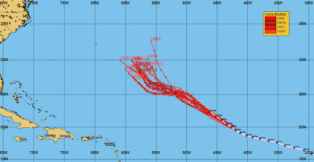
18Z GUIDANCE MODEL
18Z UKMET/NHC COMBO BY RTW
18Z H-MODEL COMBO
FLORENCE FORECAST TRACK AND WIND FIELD RADIUS
STORM INVEST 92L 18Z GUIDANCE MODEL
STORM INVEST 92L 18Z H-MODEL COMBO BY RTW


No comments:
Post a Comment
Note: Only a member of this blog may post a comment.