NATIONAL HURRICANE CENTER
000
ABNT20 KNHC 311745
TWOAT

Tropical Weather Outlook
NWS National Hurricane Center Miami FL
200 PM EDT Wed Aug 31 2022

For the North Atlantic...Caribbean Sea and the Gulf of Mexico:

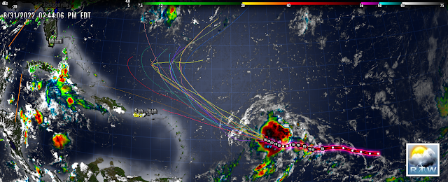
Central Tropical Atlantic:
Data from a NOAA aircraft reconnaissance mission earlier today
showed little change in organization of the area of low pressure
located several hundred miles east of the Lesser Antilles.
Although environmental conditions are only marginally conducive,
additional gradual development of this system is expected and a
tropical depression is likely to form within the next couple of
days.  The disturbance is forecast to move slowly
west-northwestward, toward the adjacent waters of the northern
Leeward Islands. Additional information on this system can be found
in High Seas Forecasts issued by the National Weather Service.
* Formation chance through 48 hours...medium...60 percent.
* Formation chance through 5 days...high...80 percent.

Eastern Tropical Atlantic:
Showers and thunderstorms associated with a broad area of low
pressure located just to the northeast of the Cabo Verde Islands
have changed little since earlier today. Some gradual development is
possible, and the system could become a short-lived tropical
depression over the far eastern Atlantic during the next
couple of days.  By late this week, environmental conditions are
forecast to become increasingly unfavorable for further development.
Regardless, the system could bring locally heavy rainfall to
portions of the Cabo Verde Islands through Thursday.
* Formation chance through 48 hours...medium...40 percent.
* Formation chance through 5 days...medium...50 percent.

Central Subtropical Atlantic:
An area of low pressure is showing signs of organization over the
central subtropical Atlantic about 850 miles west-southwest of the
westernmost Azores.  Environmental conditions are expected to be
conducive for development, and a tropical or subtropical depression
is likely to form within the next day or so, while the system
drifts generally eastward.  Additional information on this system
can be found in High Seas Forecasts issued by the National Weather
Service.
* Formation chance through 48 hours...high...70 percent.
* Formation chance through 5 days...high...80 percent.

&&
High Seas Forecasts issued by the National Weather Service
can be found under AWIPS header NFDHSFAT1, WMO header FZNT01
KWBC, and online at ocean.weather.gov/shtml/NFDHSFAT1.php

$$
Forecaster Bucci/Pasch


.gif)
.gif)
No comments:
Post a Comment
Note: Only a member of this blog may post a comment.