
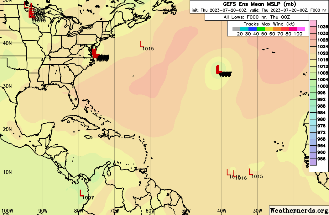
I am still monitoring models and the tropical wave storm investigation that the national hurricane center is watching with a low 0% formation chance within 48 hours and a low 20% formation chance within 7 days.
Models show this system becoming nearly stationary as it approaches 40 degrees west latitude due to weak steering currents as high pressure ridge weakens in this area. However, the high rebuilds and helps to steer this weak system to the west and into the Caribbean.
The Euro ensemble shows some development but as it nears the northwest Caribbean and into the Gulf of Mexico. However this is toward the end of the forecast run, and long range forecast are not reliable to make this assumption at this time.
Other models show a short lived system as it weakens quickly. Environmental conditions are not really favorable for any system to develop at this time.
A combination of some Sahara dry air and dust, along with upper level winds in the Atlantic are making it difficult for tropical cyclone formation. EL Nino is doing its job so far!
NHC seems to think that conditions could become a bit more favorable as it tracks further west. I will continue to monitor closely!
.gif)


ZCZC MIATWOAT ALL
TTAA00 KNHC DDHHMM

Tropical Weather Outlook
NWS National Hurricane Center Miami FL
800 AM EDT Thu Jul 20 2023

For the North Atlantic...Caribbean Sea and the Gulf of Mexico:

Active Systems:
The National Hurricane Center is issuing advisories on Tropical
Storm Don, located over the central Atlantic.

1. Eastern Tropical Atlantic:
A tropical wave located a few hundred miles southwest of the Cabo
Verde Islands is currently interacting with the Intertropical
Convergence Zone. The combination of these features is producing an
elongated area of showers and thunderstorms over the eastern
and central tropical Atlantic. While dry air to the north may
prevent significant organization during the next couple of days,
environmental conditions could become more conducive for some
development this weekend as the system moves westward across
the central tropical Atlantic.
* Formation chance through 48 hours...low...near 0 percent.
* Formation chance through 7 days...low...20 percent.

Forecaster Brown

.gif)
.gif)
000
AXNT20 KNHC 201057
TWDAT

Tropical Weather Discussion
NWS National Hurricane Center Miami FL
1205 UTC Thu Jul 20 2023

Tropical Weather Discussion for North America, Central America
Gulf of Mexico, Caribbean Sea, northern sections of South
America, and Atlantic Ocean to the African coast from the
Equator to 31N. The following information is based on satellite
imagery, weather observations, radar and meteorological analysis.

Based on 0600 UTC surface analysis and satellite imagery through
1045 UTC.

...SPECIAL FEATURES...

Tropical Storm Don is centered near 34.1N 41.6W at 20/0900 UTC.
or about 740 nm WSW of the Azores. It is moving west-northwest
at 6 kt. The estimated minimum central pressure is 1002 mb.
Maximum sustained winds are 45 kt with gusts to 55 kt. Numerous
moderate convection is present within 150 nm of the center of Don,
and within 30 nm southwest of Don. Don is forecast to continue
its current motion, with an increase in forward speeds during the
next couple of days. Don is later expected to turn northward over
the weekend. Slight strengthening is expected during the next day
or so, followed by little change in strength through Saturday.

Please read the latest NHC Public Advisory at
https://www.nhc.noaa.gov/text/MIATCPAT5.shtml and Forecast/
Advisory at https://www.nhc.noaa.gov/text/MIATCMAT5.shtml for
more details.

...TROPICAL WAVES...

A far eastern Atlantic tropical wave is west of the Cabo Verde
Islands with its axis stretching from near 19N27W to 05N31W. It
is moving westward around 10 kt. Scattered moderate convection is
within 60 nm east of the wave from 07N to 11N.

An eastern Caribbean Sea tropical wave has its axis near 69W
south of 18N to inland Venezuela. It is moving westward at about
15 kt. No significant convection is seen near this wave based on
the latest analysis.

A western Caribbean tropical wave has its axis near 88W south of
20N to inland western Honduras and continues well into the
eastern Pacific, moving westward at 15-20 kt. Scattered showers
and isolated thunderstorms are seen from 18N to 22N between 81W
and the Yucatan Peninsula.

...MONSOON TROUGH/ITCZ...

The monsoon trough axis enters the Atlantic near Nouakchott,
Mauritania, and continues southwestward to 11N30W and to 07N47W.
Aside from convection associated to the far eastern Atlantic
tropical wave, scattered moderate to isolated strong convection
is moving off the coast of Africa from 06N to 17N. Scattered
moderate convection is within 120 nm south of the trough between
22W-27W.

...GULF OF MEXICO...

The typical diurnal Yucatan Peninsula surface trough is producing
scattered showers and thunderstorms in the central Bay of
Campeche. Another surface trough along the Florida west coast is
triggering scattered showers and isolated thunderstorms over
southwestern Florida and nearby waters. A broad surface ridge
reaches west-southwestward from a 1021 mb high over the
northeastern Gulf to near Tampico, Mexico. Fresh to strong NE
winds and seas of 3-5 ft are occurring at the central and eastern
Bay of Campeche. Light to gentle winds and seas of 1-2 ft are
present across the north-central and northeastern Gulf. Gentle to
moderate E to SE winds with 2-4 ft seas prevail for the rest of
the Gulf, including the Straits of Florida.

For the forecast, high pressure will remain in control of the
weather pattern across the Gulf waters through early next week.
This should support mainly gentle to moderate winds, except fresh
to strong winds over the Bay of Campeche which will be enhanced
by a thermal trough coming off the Yucatan Peninsula during the
night hours.

...CARIBBEAN SEA...

Convergent ESE trade winds are producing scattered showers and
isolated thunderstorms near Jamaica and Hispaniola, and the
Windward Passage. Refer to the Tropical Waves section at the
beginning for additional weather in the basin. Tight pressure
gradient between the Bermuda High and lower pressure at
northwestern Colombia is sustaining strong with locally near-
gale ENE winds and seas of 8-12 ft at the south-central basin,
just north of Colombia. Fresh to strong E winds and 6 to 8 ft seas
are present for the north-central basin. Gentle to moderate NE to
E winds and seas at 3-4 ft exist just north of Panama and near
western Cuba. Moderate to fresh ENE to E winds and 4- 6 ft
prevail elsewhere in the basin.

For the forecast, fresh to strong winds will persist across the
central basin through Sat. Strong to near-gale force winds with
very rough seas are expected near the coast of Colombia and in
the Gulf of Venezuela through tonight. Moderate to locally fresh
winds will prevail in the Gulf of Honduras.

ATLANTIC OCEAN...

Please see the SPECIAL FEATURES section for the latest information
on Tropical Storm Don.

Convergent fresh east-southeast winds are generating scattered
showers and isolated thunderstorms south and southeast of Bermuda,
north of 26N between 60W-67W. Refer to the Monsoon Trough/ITCZ
and Tropical Waves sections for additional weather in the Atlantic
Basin.

The Bermuda High is supporting light to gentle winds with seas at
3 to 5 ft north of 24N between 67W and the Georgia-Florida coast,
and north of 20N between 50W and 67W. Over the central and
eastern Atlantic, surface high pressure ridging related to a 1026
mb Azores High is maintaining light to gentle winds and 3-6 ft
seas north of 20N between 27W-50W. Near the Canary Islands,
moderate to fresh NNE trades and seas of 5-7 ft dominate north of
22N between the Africa coast and 67W. Across the tropical
Atlantic, light to gentle ENE trades with 4-6 ft seas are seen
from 07N to 20N between 48W and the Lesser Antilles, and from 12N
to 20N between 27W-48W. Near the Cabo Verde Islands, gentle to
moderate NE to N winds and seas of 3-5 ft are found from 14N-20N
between 20W-27W. Gentle to moderate with locally fresh southerly
and monsoonal westerly winds and 4-6 ft in southerly swell prevail
for the remainder of the Atlantic Basin.

For the forecast west of 55W, the Bermuda High will weaken and
shift east-southeastward beginning Thu as a cold front moves
across the southeastern United States and stalls through the
weekend. This will support mainly moderate to locally fresh
winds, except for fresh to strong easterly winds and generally
moderate seas just north of Hispaniola through Thu night.

$$
Aguirre

No comments:
Post a Comment
Note: Only a member of this blog may post a comment.