
There is a strong wave off the African coast that I am monitoring closely. Where the wave is presently located, upper level conditions are favorable for some formation to occur. I will monitor in in the coming days.


The wave passing over the Caribbean is still producing some showers and storms moving over Puerto Rico. Development of this wave is not expected as it is moving toward an unfavorable upper level environment.
.gif)
.gif)

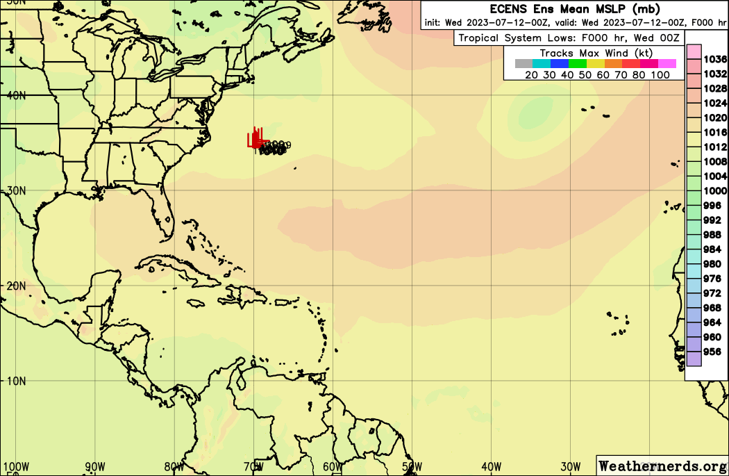
Storm Investigation 94LZCZC MIATWOAT ALL TTAA00 KNHC DDHHMM Tropical Weather Outlook NWS National Hurricane Center Miami FL 800 AM EDT Wed Jul 12 2023 For the North Atlantic...Caribbean Sea and the Gulf of Mexico: 1. Central Atlantic (AL94): An area of low pressure located more than 500 miles east-northeast of Bermuda continues to produce disorganized showers and thunderstorms well to the south of its center. Environmental conditions are forecast to be marginally conducive for some development of this system, and a subtropical or tropical depression or storm could form during the next few days while the system moves generally eastward. By the weekend, the low should turn northward bringing the system over cooler waters, potentially limiting additional development. Additional information on this system, including gale warnings, can be found in High Seas Forecasts, issued by the National Weather Service. * Formation chance through 48 hours...medium...40 percent. * Formation chance through 7 days...medium...50 percent. High Seas Forecasts issued by the National Weather Service can be found under AWIPS header NFDHSFAT1, WMO header FZNT01 KWBC, and online at ocean.weather.gov/shtml/NFDHSFAT1.php Forecaster Kelly/Berg

.gif)


435
AXNT20 KNHC 121552
TWDAT

Tropical Weather Discussion
NWS National Hurricane Center Miami FL
1805 UTC Wed Jul 12 2023

Tropical Weather Discussion for North America, Central America
Gulf of Mexico, Caribbean Sea, northern sections of South
America, and Atlantic Ocean to the African coast from the
Equator to 31N. The following information is based on satellite
imagery, weather observations, radar and meteorological analysis.

Based on 1200 UTC surface analysis and satellite imagery through
1550 UTC.

...TROPICAL WAVES...

A new tropical wave is analyzed in the eastern Atlantic,
currently extending along 22W from 20N to 07N. Scattered
moderate convection is observed from 09N to 12N between 18W and
23W.

A central Atlantic tropical wave extends along 40W from 15N to
01N, moving west at 10 to 15 kt. Isolated to scattered moderate
convection is observed from 07N to 10N between 37W and 43W.

An eastern Caribbean tropical wave extends along a line from
21N62W to 08N66W, moving west at 20 kt. Scattered moderate
convection is observed mainly west of the wave from 14N to 18N
between 63W and 73W.

A western Caribbean tropical wave extends along 85/86W, south of
21N, moving west at 20 kt. Scattered moderate convection is
observed in the Gulf of Honduras.

...MONSOON TROUGH/ITCZ...

The monsoon trough extends from the coast of Africa near 14N17W
to 10N29W. The ITCZ continues in segments from 10N29W to 10N37W
and from 08N43W to 07N53W. In addition to the convection
described in the tropical wave section, scattered weak
convection is observed along the western segment of the ITCZ
from 06N to 09N between 44W and 55W.

GULF OF MEXICO...

A surface trough is moving NW across the Bay of Campeche
supporting moderate to fresh winds and 3 to 4 ft seas over the
southwest and west-central Gulf. Elsewhere, a ridge extends from
the Atlantic to the central Gulf, supporting a gentle breeze and
slight seas.

For the forecast, a ridge will continue to dominate the Gulf
waters while a trough will develop over the Yucatan Peninsula
each evening and move offshore. This pattern will maintain
moderate to fresh winds pulsing north and west of the Yucatan
peninsula during the late afternoon and evening hours.
Elsewhere, gentle to moderate winds and slight seas will prevail.

CARIBBEAN SEA...

The gradient between a high-pressure ridge in the Atlantic and
lower pressure in the SW Caribbean Sea is enhanced by a tropical
wave in the Eastern Caribbean. Easterly trade winds are moderate
to fresh in the central and eastern Caribbean and gentle to
moderate in the NW Caribbean. Fresh NE winds are funneling
through the Windward Passage. Seas are 6-8 ft throughout the
central Caribbean, 4-6 ft in the eastern Caribbean, and 2-4 ft
in the NW Caribbean.

For the forecast, a tropical wave moving across the eastern
Caribbean will move westward to the central Caribbean through
Thu and the western Caribbean through Sun. Another tropical wave
will move across the Windward Islands Fri, across the southeast
Caribbean Sat and into the south-central Caribbean Sun. The
passage of the tropical waves will modulate fresh to strong
winds across mainly the central Caribbean through the period.

ATLANTIC OCEAN...

A cold front extends across the NW Atlantic from 31N70W to
28N80W. A line of thunderstorms is observed along the frontal
boundary. North of the front, winds are gentle from the W-NW.
South of the front, winds are moderate from the SW. Seas are
generally 3-5 ft on either side. Invest area AL94 is located
near 34N52W, with a medium chance of becoming a tropical cyclone
in the next 48 hours. While this system is north of the
discussion area, fresh to strong S winds and weak convection are
observed north of 27N between 48W and 51W. Otherwise across the
western and central basin, the subtropical ridge extends
westward along 25/26N. Winds are gentle near the ridge axis.
North of the ridge, winds are moderate to fresh from the west.
South of the ridge, winds are moderate to fresh from the east.
Seas are 4-5 ft along the ridge axis, and 5-7 ft on either side.
In the eastern Atlantic, NE winds are moderate to fresh with 5-7
ft seas. Similar conditions extend into the central Atlantic
south of 20N.

For the forecast west of 55W, high pressure will persist
northeast of the Bahamas through Sun. A weak cold front
extending from 31N69W to 28N79W will stall between NE Florida
and Bermuda late today and dissipate tonight into Thu morning.
Farther south, the northern end of a tropical wave will move
westward across the waters south of 22N through Fri. Expect
fresh to strong NE to E winds and rough seas south of 22N both
ahead of and following the tropical wave.

$$
Flynn


.gif)


.gif)


.gif)


.gif)
.gif)


.gif)

.gif)

.gif)


.gif)


.gif)

.gif)