Friday, August 4, 2023

..TROPICAL WEATHER OUTLOOK AUG 4, 2023..


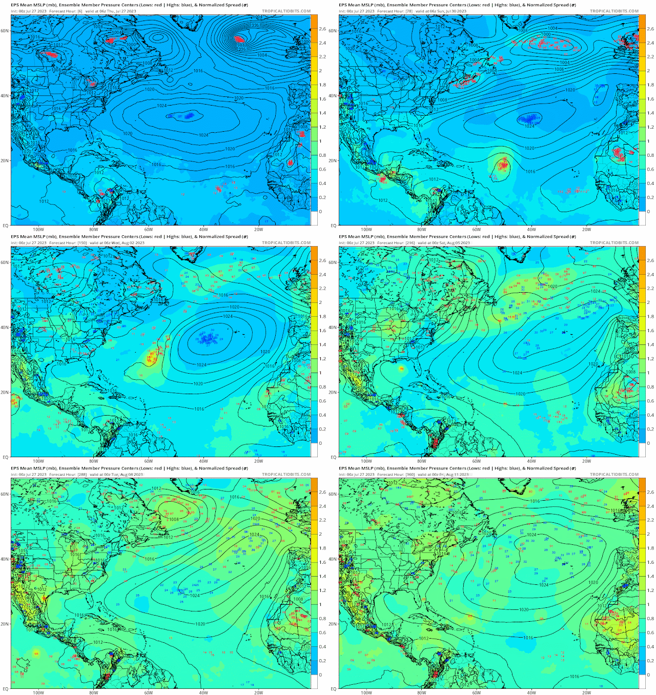
The tropics remains quiet for now but they will begin to get active by mid to late August.  I will continue to monitor as that persistent Azores high and Bermuda high are anchored in place to steer storms toward the east coast.  I hope that they do not stay in place but for now its looking that way.  we need to be storm ready this season Aug through October.

RTW

Stay tuned to NATIONAL HURRICANE CENTER for the latest updates!


Latest tropical hazard forecast call for development in the Atlantic by the third week of August.


Friday, July 28, 2023

..TROPICAL WEATHER OUTLOOK JULY 28, 2023..


Just a heads up I will be away with the family from July 28-Aug 4.  I will be doing brief updates from my cell phone as weather conditions warrant.  I will resume full tropical updates on Aug 4.

Best regards

Sorry for the inconvenience!
RTW

A strong tropical wave in the central Atlantic has a low 20% formation chance within 48 hours and a Med 60% formation chance within 7 days.  Development of this system would be more likely northeast of the Leeward Islands.  Most of the models recurve this storm system northwest then northeast and out over the north Atlantic Ocean.

Another Wave located over the Lesser Antilles has some showers and storms but no formation.


ZCZC MIATWOAT ALL
TTAA00 KNHC DDHHMM

Tropical Weather Outlook
NWS National Hurricane Center Miami FL
800 AM EDT Fri Jul 28 2023

For the North Atlantic...Caribbean Sea and the Gulf of Mexico:

1. Central Tropical Atlantic:
Shower and thunderstorm activity associated with a tropical wave 
located about midway between the Cabo Verde Islands and the Lesser 
Antilles has increased since yesterday.  Environmental conditions 
are expected to be favorable for additional gradual development of 
this system during the next few days, and a tropical depression 
could form early next week while the system moves generally 
west-northwestward over the tropical Atlantic.
* Formation chance through 48 hours...low...20 percent.
* Formation chance through 7 days...medium...60 percent.

2. Southwestern Atlantic:
Disorganized showers and thunderstorms over the far western Atlantic 
near the coasts of Georgia and northeastern Florida are associated 
with a weak area of low pressure that has formed just east of 
Jacksonville.  This system is moving north-northwestward and is 
forecast to move inland over northeastern Florida and eastern 
Georgia today, and additional development is not expected.  
Regardless of development, locally heavy rainfall is possible over 
northeastern Florida, eastern Georgia, and portions of eastern South 
Carolina during the next day or so. 
* Formation chance through 48 hours...low...near 0 percent.
* Formation chance through 7 days...low...near 0 percent.  

3. Southwestern Caribbean Sea:
A large area of disorganized showers and thunderstorms over the 
southwestern Caribbean Sea is associated with a tropical wave and 
broad area of low pressure.  This system is forecast to move 
westward over Central America later today or tonight, and 
significant development is not anticipated.  Regardless of 
development, locally heavy rainfall is possible over portions of 
Nicaragua and Honduras during the next day or so. 
* Formation chance through 48 hours...low...10 percent.
* Formation chance through 7 days...low...10 percent.  

Forecaster Brown


A strong wave approaching Central American has a low pressure disturbance ahead of the waves axis that is producing strong showers and storm with gusty winds.  This is a potential for flash flooding and deadly mudslides to occur.  Due to the proximity to land formation chance are Low 0%.


A trough of low pressure over Northern Florida is still enhancing storms over Florida today as it tracks north-northeastward.  A Flood Watch is in effect today as some of these training storms could produce localized flooding in those areas with weak drainage system.

RTW


Thursday, July 27, 2023

..TROPICAL WEATHER OUTLOOK JULY 27, 2023..


 A tropical wave between  30-35 degree west latitude is still being monitored for development.  This wave is moving through dry air and marginal upper level conditions.  This wave has a better chance for development as it passes to the northeast of the northern Leeward Islands. 

NHC is giving this wave a Low 0% formation chance within the next 48 hours and a med 40% formation chance within 7 days.


The surface trough off the Florida east coast is stuck between two upper level lows, one in the Gulf and the 2nd east of the Bahamas.  This trough has been producing strong storms over Marsh Harbor and the Abacco Island.  

As this trough tracks slowly over the Southeast Florida coast we could see some showers and storms later this afternoon.


Quantitative Precipitation Outlook


Excessive Rainfall Outlook


Ensemble models


Wednesday, July 26, 2023

..TROPICAL WEATHER OUTLOOK JULY 26, 2023..


The National Hurricane center is monitoring a tropical wave west of the Cabo Verde Island between 25-30 degrees west latitude.  This wave has a Low 0% chance for formation within 48 hours and low 30% chance for formation 7 days.  

GFS hits that this system will develop and turn northwest around the outer ridge of the Azores high missing the eastern sea board.  This is to far out in the future to say that this is what will happen.  We continue to watch and wait.

The Euro Model doesn't seem to have any interest in this wave it does not hint at development.  Will see if it gets onboard with GFS in the coming days.


Sea Surface temps are warn enough for development.

ZCZC MIATWOAT ALL
TTAA00 KNHC DDHHMM

Tropical Weather Outlook
NWS National Hurricane Center Miami FL
200 PM EDT Wed Jul 26 2023

For the North Atlantic...Caribbean Sea and the Gulf of Mexico:

1. Eastern Atlantic:
A tropical wave is located a couple of hundred miles to the 
southwest of the Cabo Verde Islands.  Conditions are expected to be 
favorable for gradual development of this system later this week and 
into the weekend while it moves westward to west-northwestward over 
the tropical Atlantic.
* Formation chance through 48 hours...low...near 0 percent.
* Formation chance through 7 days...low...30 percent.

Forecaster Pasch


EURO Model


GFS Model


A surface trough over Bahamas is interacting with an upper low South of Western Cuba and another upper level low east of the Bahamas. The counter clockwise rotation from the Southern Cuba upper low is producing enough upper level lift over the Bahamas to enhance showers and storms.  Some of the storms moved inland over Southeast Florida and the Florida straights this morning producing heavy, heavy rains, gusty winds and lightning.  This surface trough will proceed westward through Friday bringing more rains and storms.  Heavy rains, gusty winds and lightning will be possible over Southern Florida the next few days.  This could cause flooding in flood prone areas.


Metro Palm Beach County-Metro Broward County-Inland Miami-Dade
County-Metropolitan Miami Dade-Coastal Palm Beach County-Coastal
Broward County-Coastal Miami Dade County-Far South Miami-Dade County-
Including the cities of Palm Beach Gardens, Riviera Beach, Davie,
Carol City, Coral Springs, Royal Palm Ranger, Lake Worth, Hollywood,
Homestead, Delray Beach, Sandalfoot Cove, Mahogany Hammock, Boca
Raton, Kendale Lakes, Hialeah, Pembroke Pines, Deerfield Beach,
Greenacres City, West Palm Beach, Pompano Beach, Miami, Sawgrass
Mills Mal, Jupiter, Florida Gardens, Fort Lauderdale, Boynton Beach,
Miramar, Kendall, and Sunrise
136 PM EDT Wed Jul 26 2023

...FLOOD WATCH IN EFFECT FROM 8 PM EDT THIS EVENING THROUGH THURSDAY
EVENING...

* WHAT...Flooding caused by excessive rainfall is possible.

* WHERE...A portion of southeast Florida, including the following
areas, Coastal Broward County, Coastal Miami Dade County, Coastal
Palm Beach County, Far South Miami-Dade County, Inland Miami-Dade
County, Metro Broward County, Metro Palm Beach County and
Metropolitan Miami Dade.

* WHEN...From 8 PM EDT this evening through Thursday evening.

* IMPACTS...Excessive runoff may result in flooding of rivers,
creeks, streams, and other low-lying and flood-prone locations.
Flooding may occur in poor drainage and urban areas. Extensive
street flooding and flooding of creeks and rivers are possible.

* ADDITIONAL DETAILS...
- The rainfall from the showers and thunderstorms that have
been occurring over the eastern areas of South Florida the
last several days has lead to the grounds becoming saturated.
The short range models are also showing that additional 2 to
4 inches with localized higher amounts are possible through
Thursday evening with the showers and thunderstorms. Any
additional heavy rainfall amounts over these areas could
cause flooding concerns. Therefore, a Flood Watch has been
issued for the these areas through Thursday evening.
- http://www.weather.gov/safety/flood

PRECAUTIONARY/PREPAREDNESS ACTIONS...

You should monitor later forecasts and be alert for possible Flood
Warnings. Those living in areas prone to flooding should be prepared
to take action should flooding develop.


3 day rainfall totals