Wednesday, September 4, 2024

..TROPICAL OUTLOOK AUG 4, 2024..


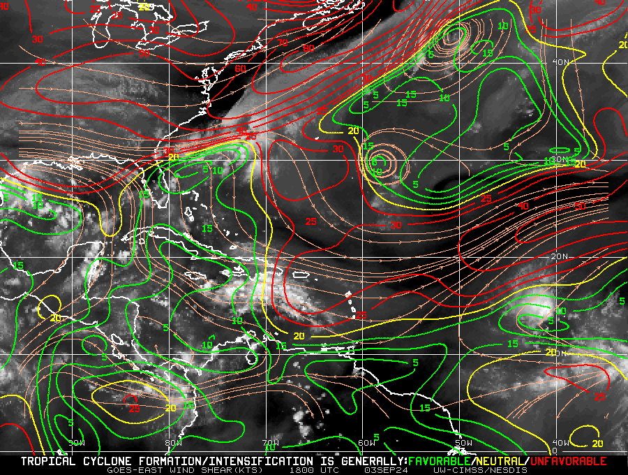
000
ABNT20 KNHC 042327
TWOAT 

Tropical Weather Outlook
NWS National Hurricane Center Miami FL
800 PM EDT Wed Sep 4 2024

For the North Atlantic...Caribbean Sea and the Gulf of Mexico:

Northwestern Atlantic:
A non-tropical area of low pressure located a few hundred miles east 
of North Carolina is producing disorganized showers and 
thunderstorms.  This system could acquire some subtropical 
characteristics over the next few days while it moves north- 
northeastward, remaining offshore of the northeastern United States. 
Additional information on this system can be found in High Seas 
Forecasts issued by the National Weather Service.
* Formation chance through 48 hours...low...10 percent.
* Formation chance through 7 days...low...20 percent.

Northwestern Caribbean Sea and Southwestern Gulf of Mexico:
A tropical wave moving quickly westward at about 20 mph is producing 
a broad area of disorganized showers and thunderstorms across 
portions of the west-central Caribbean Sea.  Some development is 
possible in a few days when the system moves over the southwestern 
Gulf of Mexico.
* Formation chance through 48 hours...low...near 0 percent. 
* Formation chance through 7 days...low...30 percent.

Central Tropical Atlantic Ocean:
Another tropical wave located several hundred miles east of the 
Lesser Antilles is producing disorganized shower and thunderstorm 
activity.  Development of this system, if any, is expected to be 
slow to occur over the next couple of days while it moves 
west-northwestward at 10 to 15 mph.  Environmental conditions are 
expected to become less favorable for additional development by the 
end of the week.
* Formation chance through 48 hours...low...10 percent. 
* Formation chance through 7 days...low...10 percent.

Eastern Tropical Atlantic Ocean:
A broad area of low pressure over the eastern tropical Atlantic is 
producing disorganized showers and thunderstorms.  Some slow 
development of this system is possible during the next several days 
while it drifts northwestward.
* Formation chance through 48 hours...low...10 percent. 
* Formation chance through 7 days...low...20 percent.

&&
High Seas Forecasts are issued by the National Weather Service 
under AWIPS header NFDHSFAT1 and WMO header FZNT01 KWBC, and online 
at ocean.weather.gov/shtml/NFDHSFAT1.php

$$
Forecaster Pasch
---------------------------------------------------------------------
218 
ACCA62 KNHC 042328
TWOSAT

Perspectiva sobre las Condiciones del Tiempo en el Trópico
Centro Nacional de Huracanes del SNM Miami FL
800 PM EDT miércoles 4 de septiembre de 2024

Para el Atlántico Norte...Mar Caribe y el Golfo de México:

Atlántico Noroeste: Un área no tropical de baja presión localizada
unos cientos de millas al este de Carolina del Norte está
produciendo aguaceros y tormentas eléctricas desorganizadas. Este
sistema podría adquirir algunas características subtropicales
durante los próximos días mientras se mueve hacia el norte- noreste,
permaneciendo en alta mar del noreste de Estados Unidos. Se puede
encontrar información adicional sobre este sistema en los
Pronósticos de Alta Mar emitidos por el Servicio Nacional de
Meteorología.
* Probabilidad de formación hasta 48 horas...baja...10 por ciento.
* Probabilidad de formación hasta 7 días...baja...20 por ciento.

Mar Caribe Noroeste y el Suroeste del Golfo de México: Una onda
tropical que se mueve rápidamente hacia el oeste a aproximadamente
20 mph está produciendo una amplia área de aguaceros y tormentas
eléctricas desorganizadas a través de porciones del Mar Caribe oeste
y central. Es posible algún desarrollo en unos días cuando el
sistema se mueve sobre el suroeste del Golfo de México.
* Probabilidad de formación hasta 48 horas...baja...cerca del 0 por
ciento.
* Probabilidad de formación hasta 7 días...baja...30 por ciento.

Océano Atlántico Tropical Central: Otra onda tropical localizada
varios cientos de millas al este de las Antillas Menores está
produciendo actividad de aguaceros y tormentas eléctricas
desorganizadas. Se espera que el desarrollo de este sistema, si lo
hay, sea lento durante los próximos dos días mientras se mueve hacia
el oeste-noroeste a 10 a 15 mph. Se espera que las condiciones
ambientales se vuelvan menos favorables para un desarrollo adicional
para el final de la semana.
* Probabilidad de formación hasta 48 horas...baja...10 por ciento.
* Probabilidad de formación hasta 7 días...baja...10 por ciento.

Océano Atlántico Tropical Este: Una amplia área de baja presión
sobre el Atlántico tropical este está produciendo aguaceros y
tormentas eléctricas desorganizadas. Es posible algún desarrollo
lento de este sistema durante los próximos días mientras se mueve
hacia el noroeste.
* Probabilidad de formación hasta 48 horas...baja...10 por ciento.
* Probabilidad de formación hasta 7 días...baja...20 por ciento.

&&
Los pronósticos de alta mar son emitidos por el Servicio Nacional de
Meteorología bajo el encabezado de AWIPS NFDHSFAT1 y el encabezado
de la OMM FZNT01 KWBC, y en línea en
ocean.weather.gov/shtml/NFDHSFAT1.php

$$
Pronosticador Pasch

*** Este producto ha sido procesado automáticamente utilizando un
programa de traducción y puede contener omisiones y errores. El
Servicio Nacional de Meteorología no puede garantizar la precisión
del texto convertido. De haber alguna duda, el texto en inglés es
siempre la versión autorizada. ***

Northern Gulf from Texas to Louisiana should continue to monitor possible development
in the Bay of Campeche.


Tuesday, September 3, 2024

..TROPICAL OUTLOOK SEPT. 3, 2024 0600 PM EDT..


September enters with the same lull we had in August: a lack of tropical cyclone development. This is due to the fact that we are still in neutral conditions with Madden-Julian oscillation (MJO) still in the Pacific, where most of the activity has been occurring. Also, the early season forecast of above-normal accumulated cyclone energy (ACE) has been lowered due to we have not transitioned into a strong La Niña as it was first forecast. This absence of La Niña and MJO in the Atlantic has allowed vertical shear in the Atlantic, and this has been suppressing development. The latest two-week forecast calls for a decrease in vertical shear and a chance for tropical development. The accumulated cyclone energy (ACE) is also down 60%, which is also good less cyclone energy for these storms to thrive on. However, we should not drop our guard because during the next two weeks, as we enter into the peak one storm, it is all it takes to cause havoc. They are still calling for some U.S. landfall before its all said and done. Let's hope they are wrong.

RTW


Friday, August 30, 2024

..TROPICAL OUTLOOK AUG 30, 2024 0600 PM EDT..


000
ABNT20 KNHC 301750
TWOAT 

Tropical Weather Outlook
NWS National Hurricane Center Miami FL
200 PM EDT Fri Aug 30 2024

For the North Atlantic...Caribbean Sea and the Gulf of Mexico:

Northwestern Gulf of Mexico:
A surface trough of low pressure over the northwestern Gulf of 
Mexico is producing a large area of disorganized showers and 
thunderstorms along and just offshore the coasts of Texas and 
Louisiana.  This system is expected to meander near the coast 
through much of next week, and some slow development is possible if 
it remains offshore.  Regardless of development, heavy rains could 
cause some flash flooding across portions of coastal Louisiana and 
the upper Texas coast during the next few days.
* Formation chance through 48 hours...low...10 percent. 
* Formation chance through 7 days...low...20 percent.

Near the Lesser Antilles and Caribbean Sea:
Showers and thunderstorms associated with a tropical wave over the 
central tropical Atlantic remain disorganized.  Gradual development 
of this system is possible during the next few days, and a tropical 
depression could form some time next week while it moves westward, 
reaching the Lesser Antilles on Monday and continuing across the 
Caribbean Sea through the middle to latter part of the week.
* Formation chance through 48 hours...low...near 0 percent. 
* Formation chance through 7 days...medium...40 percent.

Eastern Tropical Atlantic:
Another tropical wave between the west coast of Africa and the Cabo 
Verde Islands is producing minimal shower and thunderstorm 
activity.  Some slow development of this system is possible through 
late next week while it moves slowly to the west-northwest over the 
eastern and central tropical Atlantic. 
* Formation chance through 48 hours...low...near 0 percent.
* Formation chance through 7 days...low...20 percent.

$$
Forecaster Berg
---------------------------------------------------------------------
729 
ACCA62 KNHC 301752
TWOSAT

Perspectiva sobre las Condiciones del Tiempo en el Trópico
Centro Nacional de Huracanes del SNM Miami FL
200 PM EDT viernes 30 de agosto de 2024

Para el Atlántico Norte...Mar Caribe y el Golfo de México:

Noroeste del Golfo de México: Una depresión en la superficie de baja
presión sobre el noroeste del Golfo de México está produciendo una
gran área de aguaceros y tormentas eléctricas desorganizadas a lo
largo y justo en alta mar las costas de Texas y Louisiana. Se espera
que este sistema serpentee cerca de la costa hasta gran parte de la
próxima semana, y es posible algún desarrollo lento si permanece en
alta mar. Independientemente del desarrollo, las fuertes lluvias
podrían causar algunas inundaciones repentinas a través de porciones
de la Louisiana costera y la costa alta de Texas durante los
próximos días.
* Probabilidad de formación hasta 48 horas...baja...10 por ciento.
* Probabilidad de formación hasta 7 días...baja...20 por ciento.

Cerca de las Antillas Menores y el Mar Caribe: Aguaceros y tormentas
eléctricas associadas con una onda tropical sobre el Atlántico
tropical central permanecen desorganizadas. Es posible el desarrollo
gradual de este sistema durante los próximos días, y una depresión
tropical podría formarse en algún momento la próxima semana mientras
se mueve hacia el oeste, alcanzando las Antillas Menores el lunes y
continuando a través del Mar Caribe hasta la mitad a última parte de
la semana.
* Probabilidad de formación hasta 48 horas...baja...cerca del 0 por
ciento.
* Probabilidad de formación hasta 7 días...medio...40 por ciento.

Atlántico Tropical Este: Otra onda tropical entre la costa oeste de
África y las Islas de Cabo Verde está produciendo actividad mínima
de aguaceros y tormentas eléctricas. Es posible algún desarrollo
lento de este sistema hasta fines de la próxima semana mientras se
mueve lentamente al oeste-noroeste sobre el Atlántico tropical este
y central.
* Probabilidad de formación hasta 48 horas...baja...cerca del 0 por
ciento.
* Probabilidad de formación hasta 7 días...baja...20 por ciento.

$$
Pronosticador Berg

*** Este producto ha sido procesado automáticamente utilizando un
programa de traducción y puede contener omisiones y errores. El
Servicio Nacional de Meteorología no puede garantizar la precisión
del texto convertido. De haber alguna duda, el texto en inglés es
siempre la versión autorizada. ***


Thursday, August 29, 2024

..TROPICAL OUTLOOK AUG 29, 2024 0633 PM EDT..


000
ABNT20 KNHC 291730
TWOAT 

Tropical Weather Outlook
NWS National Hurricane Center Miami FL
200 PM EDT Thu Aug 29 2024

For the North Atlantic...Caribbean Sea and the Gulf of Mexico:

Central Tropical Atlantic:
A tropical wave over the central Tropical Atlantic is producing some 
disorganized showers and thunderstorms. Environmental conditions 
appear conducive for gradual development of this system, and a 
tropical depression could form by early next week while it moves 
westward at 10 to 15 mph and approaches the Lesser Antilles. 
The system is then forecast to move westward to west-northwestward 
across portions of the eastern Caribbean Sea during the middle part 
of next week.
* Formation chance through 48 hours...low...near 0 percent.
* Formation chance through 7 days...medium...40 percent.

$$
Forecaster Reinhart/Adams
-------------------------------------------------------------------
617 
ACCA62 KNHC 291731
TWOSAT

Perspectiva sobre las Condiciones del Tiempo en el Trópico
Centro Nacional de Huracanes del SNM Miami FL
200 PM EDT jueves 29 de agosto de 2024

Para el Atlántico Norte...Mar Caribe y el Golfo de México:

Atlántico Tropical Central: Una onda tropical sobre el Atlántico
Tropical central está produciendo algunos aguaceros y tormentas
eléctricas desorganizadas. Las condiciones ambientales parecen
propicias para el desarrollo gradual de este sistema, y una
depresión tropical podría formarse para principios de la próxima
semana mientras se mueve hacia el oeste a 10 a 15 mph y se acerca a
las Antillas Menores. Luego se pronostica que el sistema se moverá
hacia el oeste a oeste-noroeste a través de porciones del Mar Caribe
este durante la parte media de la próxima semana.
* Probabilidad de formación hasta 48 horas...baja...cerca del 0 por
ciento.
* Probabilidad de formación hasta 7 días...medio...40 por ciento.

$$
Pronosticador Reinhart/Adams

*** Este producto ha sido procesado automáticamente utilizando un
programa de traducción y puede contener omisiones y errores. El
Servicio Nacional de Meteorología no puede garantizar la precisión
del texto convertido. De haber alguna duda, el texto en inglés es
siempre la versión autorizada. ***


Wednesday, August 28, 2024

..TROPICAL OUTLOOK AUG 28, 2024 0606 PM EDT..


000
ABNT20 KNHC 281733
TWOAT 

Tropical Weather Outlook
NWS National Hurricane Center Miami FL
200 PM EDT Wed Aug 28 2024

For the North Atlantic...Caribbean Sea and the Gulf of Mexico:

Western Atlantic:
A small area of low pressure located a few hundred miles southeast 
of Bermuda is producing limited shower and thunderstorm activity 
well to the northeast of its center. Dry air and strong upper-level 
winds are expected to prevent development of this system while the 
low moves generally north-northeastward at about 10 mph during the 
next day or so.
* Formation chance through 48 hours...low...near 0 percent.
* Formation chance through 7 days...low...near 0 percent.

Central Tropical Atlantic:
An area of disorganized showers over the central Tropical Atlantic 
is associated with a tropical wave. Some slow development of this 
system is possible this weekend into early next week while it 
moves westward to west-northwestward at 10 to 15 mph.
* Formation chance through 48 hours...low...near 0 percent.
* Formation chance through 7 days...low...20 percent.

$$
Forecaster Reinhart
-------------------------------------------------------------------
933 
ACCA62 KNHC 281735
TWOSAT

Perspectiva sobre las Condiciones del Tiempo en el Trópico
Centro Nacional de Huracanes del SNM Miami FL
200 PM EDT miércoles 28 de agosto de 2024

Para el Atlántico Norte...Mar Caribe y el Golfo de México:

Atlántico Occidental: Una pequeña área de baja presión localizada a
unos pocos cientos de millas al sureste de Bermuda está produciendo
actividad limitada de aguaceros y tormentas eléctricas bien al
noreste de su centro. Se espera que el aire seco y fuertes vientos
de nivel superior eviten el desarrollo de este sistema mientras la
baja se mueve generalmente hacia el norte-noreste a aproximadamente
10 mph durante el próximo día más o menos.
* Probabilidad de formación hasta 48 horas...baja...cerca del 0 por
ciento.
* Probabilidad de formación hasta 7 días...baja...cerca del 0 por
ciento.

Atlántico Tropical Central: Un área de aguaceros desorganizados
sobre el Atlántico Tropical central está associada con una onda
tropical. Es posible algún desarrollo lento de este sistema este fin
de semana hasta principios de la próxima semana mientras se mueve
hacia el oeste al oeste-noroeste a 10 a 15 mph.
* Probabilidad de formación hasta 48 horas...baja...cerca del 0 por
ciento.
* Probabilidad de formación hasta 7 días...baja...20 por ciento.

$$
Pronosticador Reinhart

*** Este producto ha sido procesado automáticamente utilizando un
programa de traducción y puede contener omisiones y errores. El
Servicio Nacional de Meteorología no puede garantizar la precisión
del texto convertido. De haber alguna duda, el texto en inglés es
siempre la versión autorizada. ***

Heavy rains moving inland over Texas tomorrow as a disturbance being enhanced by a
surface trough.


Its getting busy off the African coast and in the Gulf of Mexico.

Tuesday, August 27, 2024

..TROPICAL OUTLOOK AUG 27, 2024 0615 PM EDT..


 As it is right now, there is not much to talk about in reference to these disorganized showers and storms. There is no circulation with this disorganized system at this time. Models are all over the Atlantic, so it's useless to even monitor the ensemble until there is a center of circulation with this system. For now, I continue to monitor and hope that if there is development, they will curve out to sea. 

Another strong monsoon trough is about to move off the African coast. I will watch this system as well.

The Global Tropics Hazards Outlook update is out again and still shows development over the Atlantic. But so far, that has been a bust in August. I do have to admit that this has been a very unusual hurricane season, and that is good. However, this has been a strange season, with sea surface temperatures being favorable and upper conditions as well. 

RTW

ZCZC MIATWOAT ALL
TTAA00 KNHC DDHHMM

Tropical Weather Outlook
NWS National Hurricane Center Miami FL
200 PM EDT Tue Aug 27 2024

For the North Atlantic...Caribbean Sea and the Gulf of Mexico:

1. Central Tropical Atlantic:
An area of low pressure could form in the central portion of the
Tropical Atlantic in a few days. Thereafter, environmental
conditions appear generally favorable for some slow development of
this system this weekend into early next week as it moves westward
to west-northwestward at 10 to 15 mph.
* Formation chance through 48 hours...low...near 0 percent.
* Formation chance through 7 days...low...20 percent.

Forecaster Hagen/Pasch
-------------------------------------------------------------------
823 
ACCA62 KNHC 271721
TWOSAT

Perspectiva sobre las Condiciones del Tiempo en el Trópico
Centro Nacional de Huracanes del SNM Miami FL
200 PM EDT martes 27 de agosto de 2024

Para el Atlántico Norte...Mar Caribe y el Golfo de México:

Atlántico Tropical Central: Un área de baja presión podría formarse
en la porción central del Atlántico Tropical en unos pocos días. A
partir de entonces, las condiciones ambientales parecen generalmente
favorables para algún desarrollo lento de este sistema este fin de
semana hasta principios de la próxima semana a medida que se mueve
hacia el oeste al oeste-noroeste a 10 a 15 mph.
* Probabilidad de formación hasta 48 horas...baja...cerca del 0 por
ciento.
* Probabilidad de formación hasta 7 días...baja...20 por ciento.

$$
Pronosticador Hagen/Pasch

*** Este producto ha sido procesado automáticamente utilizando un
programa de traducción y puede contener omisiones y errores. El
Servicio Nacional de Meteorología no puede garantizar la precisión
del texto convertido. De haber alguna duda, el texto en inglés es
siempre la versión autorizada. ***