STATIONARY FRONTAL BOUNDARY ALONG THE EAST COAST SHOULD KEEP JOSE FROM GETTING CLOSER LAND. HOWEVER, STRONG WINDS CAN MAKE FOR HEAVY SURF ALONG THE EASTERN SEA BOARD. COASTAL FLOODING IN HIGH TIDE ALSO POSSIBLE...RTW
SCENARIO#1 TROPICAL DEPRESSION 15 BARES WATCHING IF YOU LIVE IN THE LESSER ANTILLES, BRITISH VIRGIN ISLANDS, PUERTO RICO, DOMINICAN REPUBLIC, GREATER ANTILLES AND FLORIDA. THERE IS SUPPOSE TO BE A WEAKNESS IN THE HIGH PRESSURE RIDGE THAT JOSE WILL SUPPOSEDLY LEAVE BEHIND ITS WAKE. IF THAT WERE THE CASE THEN TD 15 WILL MOVE INTO THIS WEAKNESS AND TRACK NORTH WAY FROM THE U.S. EAST COAST. HOWEVER, THE LESSER ANTILLES PUERTO RICO WOULD BE IN THE PATH OF THIS STORM SYSTEM BEFORE THAT TURN WOULD OCCUR.
SCENARIO #2 IF THE HIGH OVER THE ATLANTIC WERE TO BUILD WEST OVER THE CYCLONE THEN THE TRACK WOULD BE WEST TO A WEST NORTHWEST AND A POSSIBLE THREAT FOR THE GREATER ANTILLES AND FLORIDA. I DON'T WANT YOU TO PANIC BUT CONTINUE TO MONITOR CLOSELY AND REPLENISH ANY SUPPLIES YOU MAY HAVE USED AFTER IRMA...RTW
AS FOR TROPICAL STORM LEE OVER THE EASTERN ATLANTIC THIS SYSTEM LOOKS LIKE IT WOULD STAY OUT OVER THE NORTH CENTRAL ATLANTIC BUT THE LATEST MODEL SUGGEST A MORE WEST-NORTHWEST TRACK. I WILL KEEP AN EYE ON THIS ONE AS WELL...RTW
Saturday, September 16, 2017
STORM INVESTIGATION 97L 12:00 AM EDT SEPT 16, 2017
STORM INVESTIGATION CONTINUES TO SHOW SIGNS OF DEVELOPMENT COULD BECOME A DEPRESSION OR TROPICAL STORM DURING A DAY OR TWO.
Friday, September 15, 2017
JOSE AND TROP DEPRESSION FOURTEEN UPDATE 11PM EDT
...JOSE A LITTLE STRONGER... ...TROPICAL STORM WATCHES POSSIBLE IN THE UNITED STATES ON SATURDAY...
000 WTNT32 KNHC 160250 TCPAT2 BULLETIN Hurricane Jose Advisory Number 43 NWS National Hurricane Center Miami FL AL122017 1100 PM EDT Fri Sep 15 2017 ...JOSE A LITTLE STRONGER... ...TROPICAL STORM WATCHES POSSIBLE IN THE UNITED STATES ON SATURDAY... SUMMARY OF 1100 PM EDT...0300 UTC...INFORMATION ----------------------------------------------- LOCATION...27.4N 71.0W ABOUT 600 MI...965 KM SSE OF CAPE HATTERAS NORTH CAROLINA ABOUT 500 MI...810 KM SW OF BERMUDA MAXIMUM SUSTAINED WINDS...80 MPH...130 KM/H PRESENT MOVEMENT...NW OR 305 DEGREES AT 9 MPH...15 KM/H MINIMUM CENTRAL PRESSURE...983 MB...29.03 INCHES WATCHES AND WARNINGS -------------------- There are no coastal watches or warnings in effect. Interests from North Carolina northward to New England on the east coast of the United States should monitor the progress of this system. A Tropical Storm Watch may be needed for a portion of the coast of North Carolina on Saturday. DISCUSSION AND 48-HOUR OUTLOOK ------------------------------ At 1100 PM EDT (0300 UTC), the center of Hurricane Jose was located near latitude 27.4 North, longitude 71.0 West. Jose is moving toward the northwest near 9 mph (15 km/h). A gradual turn toward the north is expected over the next couple of days. The estimated maximum sustained winds have increased to near 80 mph (130 km/h) with higher gusts. Additional strengthening is expected this weekend. Hurricane-force winds extend outward up to 35 miles (55 km) from the center and tropical-storm-force winds extend outward up to 150 miles (240 km). The estimated minimum central pressure is 983 mb (29.03 inches). HAZARDS AFFECTING LAND ---------------------- SURF: Swells generated by Jose are affecting Bermuda, the Bahamas, the northern coasts of Hispaniola and Puerto Rico, and the southeast coast of the United States, and will spread northward along the Mid-Atlantic coast of the U.S. during the next few days. These swells are likely to cause life-threatening surf and rip current conditions. For more information, please consult products from your local weather office. NEXT ADVISORY ------------- Next complete advisory at 500 AM EDT. $$ Forecaster Zelinsky
...DEPRESSION MOVING WESTWARD WITH NO CHANGE IN STRENGTH...
ZCZC MIATCPAT4 ALL TTAA00 KNHC DDHHMM BULLETIN Tropical Depression Fourteen Advisory Number 5 NWS National Hurricane Center Miami FL AL142017 1100 PM AST Fri Sep 15 2017 ...DEPRESSION MOVING WESTWARD WITH NO CHANGE IN STRENGTH... SUMMARY OF 1100 PM AST...0300 UTC...INFORMATION ----------------------------------------------- LOCATION...12.8N 30.7W ABOUT 500 MI...805 KM WSW OF THE CABO VERDE ISLANDS MAXIMUM SUSTAINED WINDS...35 MPH...55 KM/H PRESENT MOVEMENT...W OR 280 DEGREES AT 10 MPH...17 KM/H MINIMUM CENTRAL PRESSURE...1009 MB...29.80 INCHES WATCHES AND WARNINGS -------------------- There are no coastal watches or warnings in effect. DISCUSSION AND 48-HOUR OUTLOOK ------------------------------ At 1100 PM AST (0300 UTC), the center of Tropical Depression Fourteen was located near latitude 12.8 North, longitude 30.7 West. The depression is moving toward the west near 10 mph (17 km/h), and a westward motion with some decrease in forward speed is expected over the next couple of days. Maximum sustained winds are near 35 mph (55 km/h) with higher gusts. Some slightly strengthening is possible, and the depression could become a tropical storm over the weekend. The estimated minimum central pressure is 1009 mb (29.80 inches). HAZARDS AFFECTING LAND ---------------------- None NEXT ADVISORY ------------- Next complete advisory at 500 AM AST. $$ Forecaster Brown
JOSE A HURRICANE AGAIN AND DEPRESSION 14 IS POORLY ORGANIZED 05 PM EDT
...JOSE BECOMES A HURRICANE AGAIN... ...TROPICAL STORM WATCHES POSSIBLE IN THE UNITED STATES ON SATURDAY...
ZCZC MIATCPAT2 ALL TTAA00 KNHC DDHHMM BULLETIN Hurricane Jose Advisory Number 42 NWS National Hurricane Center Miami FL AL122017 500 PM EDT Fri Sep 15 2017 ...JOSE BECOMES A HURRICANE AGAIN... ...TROPICAL STORM WATCHES POSSIBLE IN THE UNITED STATES ON SATURDAY... SUMMARY OF 500 PM EDT...2100 UTC...INFORMATION ---------------------------------------------- 
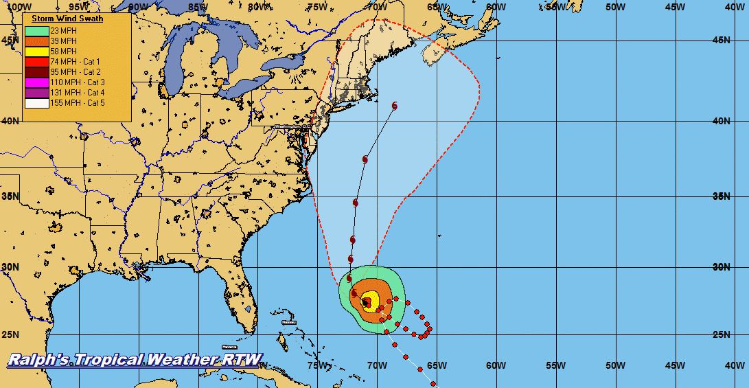
LOCATION...27.1N 70.3W ABOUT 640 MI...1025 KM SSE OF CAPE HATTERAS NORTH CAROLINA ABOUT 485 MI...785 KM SW OF BERMUDA MAXIMUM SUSTAINED WINDS...75 MPH...120 KM/H PRESENT MOVEMENT...NW OR 305 DEGREES AT 10 MPH...17 KM/H MINIMUM CENTRAL PRESSURE...983 MB...29.03 INCHES WATCHES AND WARNINGS -------------------- There are no coastal watches or warnings in effect. Interests from North Carolina northward to New England on the east coast of the United States should monitor the progress of this system. A Tropical Storm Watch may be needed for a portion of the coast of North Carolina on Saturday. DISCUSSION AND 48-HOUR OUTLOOK ------------------------------ At 500 PM EDT (2100 UTC), the center of Hurricane Jose was located near latitude 27.1 North, longitude 70.3 West. Jose is moving toward the northwest near 10 mph (17 km/h). This general motion is expected today, follow by a turn to the north-northwest by late Saturday and toward the north on Sunday. Maximum sustained winds have increased to near 75 mph (120 km/h) with higher gusts. Some strengthening is forecast through Saturday, with weakening possibly beginning on late Sunday. Hurricane-force winds extend outward up to 35 miles (55 km) from the center and tropical-storm-force winds extend outward up to 140 miles (220 km). The minimum central pressure as estimated from Air Force Reserve Hurricane Hunter data is 983 mb (29.03 inches). HAZARDS AFFECTING LAND ---------------------- SURF: Swells generated by Jose are affecting Bermuda, the Bahamas, the northern coasts of Hispaniola and Puerto Rico, and the southeast coast of the United States, and will spread northward along the Mid-Atlantic coast of the U.S. during the next few days. These swells are likely to cause life-threatening surf and rip current conditions. For more information, please consult products from your local weather office. NEXT ADVISORY ------------- Next complete advisory at 1100 PM EDT. $$ Forecaster Blake
...DEPRESSION POORLY ORGANIZED BUT FORECAST TO BECOME A TROPICAL STORM OVER THE WEEKEND...
ZCZC MIATCPAT4 ALL TTAA00 KNHC DDHHMM BULLETIN 
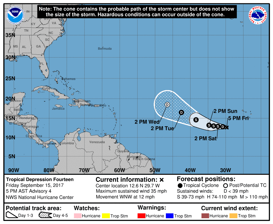
Tropical Depression Fourteen Advisory Number 4 NWS National Hurricane Center Miami FL AL142017 500 PM AST Fri Sep 15 2017 ...DEPRESSION POORLY ORGANIZED BUT FORECAST TO BECOME A TROPICAL STORM OVER THE WEEKEND... SUMMARY OF 500 PM AST...2100 UTC...INFORMATION ---------------------------------------------- LOCATION...12.6N 29.7W ABOUT 450 MI...720 KM WSW OF THE CABO VERDE ISLANDS MAXIMUM SUSTAINED WINDS...35 MPH...55 KM/H PRESENT MOVEMENT...WNW OR 285 DEGREES AT 12 MPH...19 KM/H MINIMUM CENTRAL PRESSURE...1009 MB...29.80 INCHES WATCHES AND WARNINGS -------------------- There are no coastal watches or warnings in effect. DISCUSSION AND 48-HOUR OUTLOOK ------------------------------ At 500 PM AST (2100 UTC), the center of Tropical Depression Fourteen was located near latitude 12.6 North, longitude 29.7 West. The depression is moving toward the west-northwest near 12 mph (19 km/h), and a west or west-northwest motion is forecast during the next couple of days. Maximum sustained winds are near 35 mph (55 km/h) with higher gusts. Some gradual strengthening is expected, and the depression is forecast to become a tropical storm over the weekend. The estimated minimum central pressure is 1009 mb (29.80 inches). HAZARDS AFFECTING LAND ---------------------- None NEXT ADVISORY ------------- Next complete advisory at 1100 PM AST. $$ Forecaster Brown
12z MODEL RUN FOR 96L IN THE CENTRAL ATLANTIC.
I BELIEVE THAT JOSE WILL LEAVE A WEAKNESS IN THE HIGH PRESSURE FOR THIS SYSTEM TO FOLLOW BEHIND JOSE. LETS HOPE I AM CORRECT.
JOSE AND TROPICAL DEPRESSION 14 UPDATE 11PM EDT 9/15/17
...JOSE EXPECTED TO PRODUCE HIGH SURF AND LIFE-THREATENING RIP
CURRENTS ALONG PORTIONS OF THE U.S. EAST COAST...
...TROPICAL DEPRESSION MOVING WESTWARD OVER THE FAR EASTERN ATLANTIC......FORECAST TO BECOME A TROPICAL STORM...
000 WTNT32 KNHC 151452 TCPAT2 BULLETIN Tropical Storm Jose Advisory Number 41 NWS National Hurricane Center Miami FL AL122017 1100 AM AST Fri Sep 15 2017 ...AN AIR FORCE PLANE IS EN ROUTE TO DETERMINE IF JOSE IS A HURRICANE AGAIN... SUMMARY OF 1100 AM AST...1500 UTC...INFORMATION ----------------------------------------------- LOCATION...26.5N 69.4W ABOUT 360 MI...575 KM NE OF THE SOUTHEASTERN BAHAMAS ABOUT 485 MI...785 KM SW OF BERMUDA MAXIMUM SUSTAINED WINDS...70 MPH...110 KM/H PRESENT MOVEMENT...NW OR 305 DEGREES AT 9 MPH...15 KM/H MINIMUM CENTRAL PRESSURE...989 MB...29.21 INCHES WATCHES AND WARNINGS -------------------- There are no coastal watches or warnings in effect. Interests from North Carolina northward to New England on the east coast of the United States should monitor the progress of this system. DISCUSSION AND 48-HOUR OUTLOOK ------------------------------ At 1100 AM AST (1500 UTC), the center of Tropical Storm Jose was located near latitude 26.5 North, longitude 69.4 West. Jose is moving toward the northwest near 9 mph (15 km/h). This general motion is expected today, follow by a turn to the north-northwest by late Saturday and toward the north on Sunday. Maximum sustained winds remain near 70 mph (110 km/h) with higher gusts. Some strengthening is forecast during the next 48 hours. An Force Reserve Hurricane Hunter aircraft is currently en route to obtain a better wind speed estimate. Tropical-storm-force winds extend outward up to 140 miles (220 km) from the center. The estimated minimum central pressure is 989 mb (29.21 inches). HAZARDS AFFECTING LAND ---------------------- SURF: Swells generated by Jose are affecting Bermuda, the Bahamas, the northern coasts of Hispaniola and Puerto Rico, and the southeast coast of the United States, and will spread northward along the Mid-Atlantic coast of the U.S. during the next few days. These swells are likely to cause life-threatening surf and rip current conditions. For more information, please consult products from your local weather office. NEXT ADVISORY ------------- Next complete advisory at 500 PM AST. $$ Forecaster Blake
000 WTNT34 KNHC 151433 TCPAT4 BULLETIN Tropical Depression Fourteen Advisory Number 3 NWS National Hurricane Center Miami FL AL142017 1100 AM AST Fri Sep 15 2017 ...DEPRESSION FORECAST TO BECOME A TROPICAL STORM LATER TODAY... SUMMARY OF 1100 AM AST...1500 UTC...INFORMATION ----------------------------------------------- LOCATION...11.4N 28.3W ABOUT 430 MI...690 KM SW OF THE CABO VERDE ISLANDS MAXIMUM SUSTAINED WINDS...35 MPH...55 KM/H PRESENT MOVEMENT...WNW OR 285 DEGREES AT 10 MPH...17 KM/H MINIMUM CENTRAL PRESSURE...1008 MB...29.77 INCHES WATCHES AND WARNINGS -------------------- There are no coastal watches or warnings in effect. DISCUSSION AND 48-HOUR OUTLOOK ------------------------------ At 1100 AM AST (1500 UTC), the center of Tropical Depression Fourteen was located near latitude 11.4 North, longitude 28.3 West. The depression is moving toward the west-northwest near 10 mph (17 km/h), and a west or west-northwest motion is forecast during the next couple of days. Maximum sustained winds are near 35 mph (55 km/h) with higher gusts. The depression is forecast to become a tropical storm later today. The estimated minimum central pressure is 1008 mb (29.77 inches). HAZARDS AFFECTING LAND ---------------------- None NEXT ADVISORY ------------- Next complete advisory at 500 PM AST. $$ Forecaster Blake
Thursday, September 14, 2017
JOSE AND TROPICAL DEPRESSION 14 UPDATE 11 PM EDT SEPT 14, 2017
...JOSE STILL A TROPICAL STORM BUT EXPECTED TO STRENGTHEN...
...LIFE-THREATENING RIP CURRENTS POSSIBLE ALONG PORTIONS OF THE
U.S. EAST COAST...
ZCZC MIATCPAT2 ALL TTAA00 KNHC DDHHMM BULLETIN Tropical Storm Jose Advisory Number 39 NWS National Hurricane Center Miami FL AL122017 1100 PM AST Thu Sep 14 2017 ...JOSE STILL A TROPICAL STORM BUT EXPECTED TO STRENGTHEN... ...LIFE-THREATENING RIP CURRENTS POSSIBLE ALONG PORTIONS OF THE U.S. EAST COAST... SUMMARY OF 1100 PM AST...0300 UTC...INFORMATION ----------------------------------------------- LOCATION...25.5N 68.0W ABOUT 375 MI...605 KM NE OF THE SOUTHEASTERN BAHAMAS ABOUT 510 MI...815 KM SSW OF BERMUDA MAXIMUM SUSTAINED WINDS...70 MPH...110 KM/H PRESENT MOVEMENT...WNW OR 285 DEGREES AT 8 MPH...13 KM/H MINIMUM CENTRAL PRESSURE...989 MB...29.21 INCHES WATCHES AND WARNINGS -------------------- There are no coastal watches or warnings in effect. Interests from North Carolina northward to New England on the east coast of the United States should monitor the progress of this system. DISCUSSION AND 48-HOUR OUTLOOK ------------------------------ At 1100 PM AST (0300 UTC), the center of Tropical Storm Jose was located near latitude 25.5 North, longitude 68.0 West. Jose is moving toward the west-northwest near 8 mph (13 km/h). A gradual turn toward the north is expected during the next two days. Maximum sustained winds are near 70 mph (110 km/h) with higher gusts. Some strengthening is forecast during the next 48 hours, and Jose is expected to regain hurricane status on Friday. Tropical-storm-force winds extend outward up to 140 miles (220 km) from the center. The estimated minimum central pressure is 989 mb (29.21 inches). HAZARDS AFFECTING LAND ---------------------- SURF: Swells generated by Jose are affecting Bermuda, the Bahamas, the northern coasts of Hispaniola and Puerto Rico, and the Southeast coast of the United States, and will spread northward along the Mid-Atlantic coast of the U.S. during the next few days. These swells are likely to cause life-threatening surf and rip current conditions. For more information, please consult products from your local weather office. NEXT ADVISORY ------------- Next complete advisory at 500 AM AST. $$ Forecaster Zelinsky
...TROPICAL DEPRESSION FORMS OVER THE EASTERN ATLANTIC...
ZCZC MIATCPAT4 ALL TTAA00 KNHC DDHHMM BULLETIN Tropical Depression Fourteen Advisory Number 1 NWS National Hurricane Center Miami FL AL142017 1100 PM AST Thu Sep 14 2017 ...TROPICAL DEPRESSION FORMS OVER THE EASTERN ATLANTIC... SUMMARY OF 1100 PM AST...0300 UTC...INFORMATION ----------------------------------------------- LOCATION...10.7N 25.4W ABOUT 380 MI...610 KM SSW OF THE CABO VERDE ISLANDS MAXIMUM SUSTAINED WINDS...35 MPH...55 KM/H PRESENT MOVEMENT...WNW OR 285 DEGREES AT 22 MPH...35 KM/H MINIMUM CENTRAL PRESSURE...1010 MB...29.83 INCHES WATCHES AND WARNINGS -------------------- There are no coastal watches or warnings in effect. DISCUSSION AND 48-HOUR OUTLOOK ------------------------------ At 1100 PM AST (0300 UTC), the center of Tropical Depression Fourteen was located near latitude 10.7 North, longitude 25.4 West. The depression is moving toward the west-northwest near 22 mph (35 km/h). A slower westward motion is forecast to begin on Friday and continue through Saturday. Maximum sustained winds are near 35 mph (55 km/h) with higher gusts. Strengthening is expected during the next couple of days, and the depression is forecast to become a tropical storm later tonight or Friday. The estimated minimum central pressure is 1010 mb (29.83 inches). HAZARDS AFFECTING LAND ---------------------- None NEXT ADVISORY ------------- Next complete advisory at 500 AM AST. $$ Forecaster Brown
TROPICAL STORM JOSE AND INVEST 97L 00z MODEL RUN 1023 PM EDT 9/14/17
JOSE TRACK COMES REAL CLOSE TO THE NORTHEAST AND CANNOT BE DISREGARDED. THOSE WHO LIVE ALONG THE NORTHEAST COAST SHOULD CLOSELY MONITOR JOSE FUTURE TRACK.
STORM INVEST 97L 00Z MODELS ARE ALL OVER THE PLACE BUT IT WILL BE MONITORED AS IT TRACKS ACROSS THE ATLANTIC.
STORM INVESTIGATION 97L
MOST OF THE MODELS SUGGEST A STORM OUT AT SEA. HOWEVER, IRMA'S TRACK WAS LIKE THAT AT FIRST THEN HIGH PRESSURE BUILD OVER IRMA AND STEERED HER THIS WAY. REAL FAR AWAY TO BE CONCERNED ABOUT THIS DISTURBANCE.
SORRY OUT FROM WORK TODAY LOWER BACK PAIN HERE IS JOSE UPDATE
...LIFE-THREATENING RIP CURRENTS POSSIBLE ALONG PORTIONS OF THE U.S. EAST COAST FROM JOSE...
ZCZC MIATCPAT2 ALL TTAA00 KNHC DDHHMM BULLETIN Tropical Storm Jose Advisory Number 38 NWS National Hurricane Center Miami FL AL122017 500 PM AST Thu Sep 14 2017 ...LIFE-THREATENING RIP CURRENTS POSSIBLE ALONG PORTIONS OF THE U.S. EAST COAST FROM JOSE... SUMMARY OF 500 PM AST...2100 UTC...INFORMATION ---------------------------------------------- LOCATION...25.2N 67.3W ABOUT 405 MI...650 KM ENE OF THE SOUTHEASTERN BAHAMAS ABOUT 515 MI...825 KM SSW OF BERMUDA MAXIMUM SUSTAINED WINDS...70 MPH...110 KM/H PRESENT MOVEMENT...WNW OR 290 DEGREES AT 8 MPH...13 KM/H MINIMUM CENTRAL PRESSURE...989 MB...29.21 INCHES WATCHES AND WARNINGS -------------------- There are no coastal watches or warnings in effect. Interests from North Carolina northward to New England on the east coast of the United States should monitor the progress of this system. DISCUSSION AND 48-HOUR OUTLOOK ------------------------------ At 500 PM AST (2100 UTC), the center of Tropical Storm Jose was located near latitude 25.2 North, longitude 67.3 West. Jose is moving toward the west-northwest near 8 mph (13 km/h), and this motion is expected to continue through Friday, followed by a turn to the northwest on Saturday. Maximum sustained winds remain near 70 mph (110 km/h) with higher gusts. Some restrengthening is forecast to begin on Friday, and Jose will likely become a hurricane again by the weekend. Tropical-storm-force winds extend outward up to 140 miles (220 km) from the center. The estimated minimum central pressure is 989 mb (29.21 inches). HAZARDS AFFECTING LAND ---------------------- SURF: Swells generated by Jose are affecting Bermuda, the Bahamas, the northern coasts of Hispaniola and Puerto Rico, and the Southeast coast of the United States, and will spread northward along the Mid-Atlantic coast of the U.S. during the next few days. These swells are likely to cause life-threatening surf and rip current conditions. For more information, please consult products from your local weather office. NEXT ADVISORY ------------- Next complete advisory at 1100 PM AST. $$ Forecaster Blake
Subscribe to:
Posts (Atom)