Sunday, September 17, 2017

ATLANTIC STORMS UPDATE 0555 AM EDT SEPT 17, 2017

 ...JOSE MOVING A LITTLE FASTER NORTHWARD WITH NO CHANGE IN STRENGTH... ...DANGEROUS SURF AND RIP CURRENTS EXPECTED ALONG THE EAST COAST OF THE UNITED STATES...

000
WTNT32 KNHC 170849
TCPAT2

BULLETIN
Hurricane Jose Advisory Number  48
NWS National Hurricane Center Miami FL       AL122017
500 AM EDT Sun Sep 17 2017

...JOSE MOVING A LITTLE FASTER NORTHWARD WITH NO CHANGE IN
STRENGTH...
...DANGEROUS SURF AND RIP CURRENTS EXPECTED ALONG THE EAST
COAST OF THE UNITED STATES...


SUMMARY OF 500 AM EDT...0900 UTC...INFORMATION
----------------------------------------------
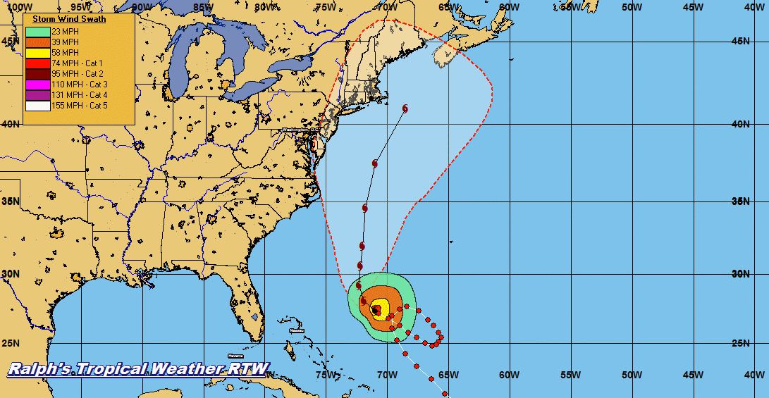
LOCATION...30.0N 71.7W
ABOUT 420 MI...680 KM SSE OF CAPE HATTERAS NORTH CAROLINA
ABOUT 435 MI...705 KM WSW OF BERMUDA
MAXIMUM SUSTAINED WINDS...80 MPH...130 KM/H
PRESENT MOVEMENT...N OR 360 DEGREES AT 8 MPH...13 KM/H
MINIMUM CENTRAL PRESSURE...973 MB...28.74 INCHES


WATCHES AND WARNINGS
--------------------
There are no coastal watches or warnings in effect.

Interests from North Carolina northward to New England on the east
coast of the United States should monitor the progress of this
system.  Tropical storm watches may be needed for portions of this
area during the next day or two.


DISCUSSION AND 48-HOUR OUTLOOK
------------------------------
At 500 AM EDT (0900 UTC), the center of Hurricane Jose was located
near latitude 30.0 North, longitude 71.7 West.  Jose is moving
toward the north near 8 mph (13 km/h), and this general motion with
a slight increase in forward speed is expected through early
Tuesday.

Maximum sustained winds are near 80 mph (130 km/h) with higher
gusts.  Some fluctuations in intensity are possible over the
next couple of days, but Jose is forecast to remain a hurricane
through early Tuesday.

Hurricane-force winds extend outward up to 45 miles (75 km) from the
center and tropical-storm-force winds extend outward up to 185 miles
(295 km).

The estimated minimum central pressure is 973 mb (28.74 inches).


HAZARDS AFFECTING LAND
----------------------
SURF:  Swells generated by Jose are affecting Bermuda, the Bahamas,
the northern coasts of Hispaniola and Puerto Rico, and much of the
U.S. east coast. These swells are likely to cause dangerous surf and
rip current conditions for the next several days in these areas.
For more information, please consult products from your local
weather office.


NEXT ADVISORY
-------------
Next complete advisory at 1100 AM EDT.

$$
Forecaster Roberts 


LOOKS LIKE JOSE WILL GET STUCK IN ANOTHER BLOCKED STEERING ENVIRONMENT AS YOU SEE ALL THOSE LOOPS AT THE END OF THE FORECAST.  THIS COULD ALSO DETERMINE HOW FAR NORTH MARIA WILL GO IF AT ALL.
 
...LEE MOVING SLOWLY WESTWARD OVER THE OPEN EASTERN ATLANTIC...

ZCZC MIATCPAT4 ALL
TTAA00 KNHC DDHHMM

BULLETIN
Tropical Storm Lee Advisory Number  10
NWS National Hurricane Center Miami FL       AL142017
500 AM AST Sun Sep 17 2017

...LEE MOVING SLOWLY WESTWARD OVER THE OPEN EASTERN ATLANTIC...


SUMMARY OF 500 AM AST...0900 UTC...INFORMATION
----------------------------------------------
LOCATION...13.0N 35.4W
ABOUT 790 MI...1270 KM WSW OF THE CABO VERDE ISLANDS
MAXIMUM SUSTAINED WINDS...40 MPH...65 KM/H
PRESENT MOVEMENT...W OR 280 DEGREES AT 7 MPH...11 KM/H
MINIMUM CENTRAL PRESSURE...1007 MB...29.74 INCHES


WATCHES AND WARNINGS
--------------------
There are no coastal watches or warnings in effect.


DISCUSSION AND 48-HOUR OUTLOOK
------------------------------
At 500 AM AST (0900 UTC), the center of Tropical Storm Lee was
located near latitude 13.0 North, longitude 35.4 West.  Lee is
moving toward the west near 7 mph (11 km/h), and this motion is
forecast to continue through Monday morning.  A west-northwestward
motion is expected Monday afternoon.

Maximum sustained winds are near 40 mph (65 km/h) with higher gusts.
Little change in strength is forecast through Monday, and Lee is
expected to weaken to a depression on Tuesday.

Tropical-storm-force winds extend outward up to 60 miles (95 km)
from the center.

The estimated minimum central pressure is 1007 mb (29.74 inches).


HAZARDS AFFECTING LAND
----------------------
None


NEXT ADVISORY
-------------
Next complete advisory at 1100 AM AST.

$$
Forecaster Roberts


...MARIA STRENGTHENING...

ZCZC MIATCPAT5 ALL
TTAA00 KNHC DDHHMM

BULLETIN
Tropical Storm Maria Advisory Number   4
NWS National Hurricane Center Miami FL       AL152017
500 AM AST Sun Sep 17 2017

...MARIA STRENGTHENING...


SUMMARY OF 500 AM AST...0900 UTC...INFORMATION
----------------------------------------------
LOCATION...13.0N 54.9W
ABOUT 460 MI...740 KM ESE OF THE LESSER ANTILLES
MAXIMUM SUSTAINED WINDS...65 MPH...100 KM/H
PRESENT MOVEMENT...WNW OR 290 DEGREES AT 15 MPH...24 KM/H
MINIMUM CENTRAL PRESSURE...994 MB...29.36 INCHES


WATCHES AND WARNINGS
--------------------
CHANGES WITH THIS ADVISORY:

The government of Barbados has changed the Tropical Storm Watch for
Dominica to a Hurricane Watch.

SUMMARY OF WATCHES AND WARNINGS IN EFFECT:

A Hurricane Watch is in effect for...
* Antigua, Barbuda, St. Kitts, Nevis, and Montserrat
* Guadeloupe
* Dominica
* Saba and St. Eustatius
* St. Maarten
* Anguilla

A Tropical Storm Watch is in effect for...
* St. Lucia
* Martinique
* Barbados
* St. Vincent and the Grenadines

A Hurricane Watch means that hurricane conditions are possible
within the watch area.  A watch is typically issued 48 hours
before the anticipated first occurrence of tropical-storm-force
winds, conditions that make outside preparations difficult or
dangerous.

A Tropical Storm Watch means that tropical storm conditions are
possible within the watch area, generally within 48 hours.

Interests elsewhere in the Lesser Antilles and the British and U. S.
Virgin Islands should monitor the progress of this system.
Additional Tropical Storm or Hurricane Watches and Warnings will
likely be issued today.

For storm information specific to your area, please monitor
products issued by your national meteorological service.


DISCUSSION AND 48-HOUR OUTLOOK
------------------------------
At 500 AM AST (0900 UTC), the center of Tropical Storm Maria was
located near latitude 13.0 North, longitude 54.9 West. Maria is
moving toward the west-northwest near 15 mph (24 km/h) and this
motion with a further reduction in forward speed is expected over
the next couple of days.  On the forecast track, the center of
Maria will be near the Leeward Islands Monday night.

Maximum sustained winds have increased to near 65 mph (100 km/h)
with higher gusts.  Additional strengthening is forecast during the
next 48 hours, and Maria will likely become a hurricane later today.

Tropical-storm-force winds extend outward up to 60 miles (95 km)
from the center.

The estimated minimum central pressure is 994 mb (29.36 inches).


HAZARDS AFFECTING LAND
----------------------
WIND:  Hurricane conditions are possible within the hurricane watch
area by Monday night or Tuesday, with tropical storm conditions
possible on Monday.  Tropical storm conditions are possible in the
Tropical Storm Watch area on Monday.

STORM SURGE:  A dangerous storm surge accompanied by large and
destructive waves will raise water levels by as much as 3 to 5 feet
above normal tide levels within the Hurricane Watch area.

RAINFALL:  Maria is expected to produce total rain accumulations of
6 to 12 inches with isolated maximum amounts of 20 inches across the
central and southern Leeward Islands through Wednesday night.  Maria
is also expected to produce total rain accumulations of 2 to 4
inches with isolated maximum amounts of 8 inches in the northern
Leeward Islands and north-central Windward Islands.  This rainfall
could cause life-threatening flash floods and mudslides.

SURF:  Swells generated by Maria are expected to begin affecting the
Lesser Antilles by tonight.  These swells are likely to cause
life-threatening surf and rip current conditions.  Please consult
products from your local weather office.


NEXT ADVISORY
-------------
Next intermediate advisory at 800 AM AST.
Next complete advisory at 1100 AM AST.

$$
Forecaster Pasch


SOME MODELS TRENDING NORTHWARD IN RESPONSE TO WEAKNESS IN HIGH JOSE HAS LEFT BEHIND IN ITS WAKE.
 
COMBO MODEL RUN: THERE SEEMS TO BE A SLIGHT BEND NORTHWARD IN THAT PAST FEW MODEL RUN WILL SEE IF THAT TREND CONTINUES SINCE A WEAKNESS IN THE HIGH PRESSURE RIDGE NORTH OF THE BAHAMAS IS LEFT BEHIND BY JOSE'S WAKE.

Saturday, September 16, 2017

LATEST STORM UPDATE 1123 PM EDT SEPT 16, 2017

...JOSE CONTINUES TO MOVE SLOWLY NORTHWARD... ...DANGEROUS SURF AND RIP CURRENTS EXPECTED ALONG THE EAST COAST OF THE UNITED STATES...

000
WTNT32 KNHC 170238
TCPAT2

BULLETIN
Hurricane Jose Advisory Number  47
NWS National Hurricane Center Miami FL       AL122017
1100 PM EDT Sat Sep 16 2017

...JOSE CONTINUES TO MOVE SLOWLY NORTHWARD...
...DANGEROUS SURF AND RIP CURRENTS EXPECTED ALONG THE EAST
COAST OF THE UNITED STATES...


SUMMARY OF 1100 PM EDT...0300 UTC...INFORMATION
-----------------------------------------------
LOCATION...29.2N 71.8W
ABOUT 465 MI...750 KM SSE OF CAPE HATTERAS NORTH CAROLINA
ABOUT 465 MI...750 KM WSW OF BERMUDA
MAXIMUM SUSTAINED WINDS...80 MPH...130 KM/H
PRESENT MOVEMENT...N OR 360 DEGREES AT 7 MPH...11 KM/H
MINIMUM CENTRAL PRESSURE...973 MB...28.74 INCHES


WATCHES AND WARNINGS
--------------------
There are no coastal watches or warnings in effect.

Interests from North Carolina northward to New England on the east
coast of the United States should monitor the progress of this
system.  Tropical storm watches may be needed for portions of this
area during the next day or two.


DISCUSSION AND 48-HOUR OUTLOOK
------------------------------
At 1100 PM EDT (0300 UTC), the center of Hurricane Jose was located
near latitude 29.2 North, longitude 71.8 West. Jose is moving toward
the north near 7 mph (11 km/h), and this general motion with a
slight increase in forward speed is expected through Monday night.

Maximum sustained winds are near 80 mph (130 km/h) with higher
gusts.  Some fluctuations in intensity are possible over the
next couple of days, but Jose is forecast to remain a hurricane
through Monday night.

Hurricane-force winds extend outward up to 45 miles (75 km) from the
center and tropical-storm-force winds extend outward up to 185 miles
(295 km).

The estimated minimum central pressure is 973 mb (28.74 inches).


HAZARDS AFFECTING LAND
----------------------
SURF:  Swells generated by Jose are affecting Bermuda, the Bahamas,
the northern coasts of Hispaniola and Puerto Rico, and much of the
U.S. east coast. These swells are likely to cause dangerous surf and
rip current conditions for the next several days in these areas.
For more information, please consult products from your local
weather office.


NEXT ADVISORY
-------------
Next complete advisory at 500 AM EDT.

$$
Forecaster Brown


...LEE MOVING WESTWARD AND NOT EXPECTED TO STRENGTHEN...

ZCZC MIATCPAT4 ALL
TTAA00 KNHC DDHHMM

BULLETIN
Tropical Storm Lee Advisory Number   9
NWS National Hurricane Center Miami FL       AL142017
1100 PM AST Sat Sep 16 2017

...LEE MOVING WESTWARD AND NOT EXPECTED TO STRENGTHEN...


SUMMARY OF 1100 PM AST...0300 UTC...INFORMATION
-----------------------------------------------
LOCATION...12.8N 34.9W
ABOUT 760 MI...1225 KM WSW OF THE CABO VERDE ISLANDS
MAXIMUM SUSTAINED WINDS...40 MPH...65 KM/H
PRESENT MOVEMENT...W OR 275 DEGREES AT 8 MPH...13 KM/H
MINIMUM CENTRAL PRESSURE...1007 MB...29.74 INCHES


WATCHES AND WARNINGS
--------------------
There are no coastal watches or warnings in effect.


DISCUSSION AND 48-HOUR OUTLOOK
------------------------------
At 1100 PM AST (0300 UTC), the center of Tropical Storm Lee was
located near latitude 12.8 North, longitude 34.9 West. Lee is moving
toward the west near 8 mph (13 km/h), and this motion is forecast to
continue through Sunday afternoon.  A west-northwestward motion is
expected Sunday night and Monday.

Maximum sustained winds are near 40 mph (65 km/h) with higher gusts.
Little change in strength is forecast during the next 48 hours.

Tropical-storm-force winds extend outward up to 60 miles (95 km)
mainly to the south of the center.

The estimated minimum central pressure is 1007 mb (29.74 inches).


HAZARDS AFFECTING LAND
----------------------
None


NEXT ADVISORY
-------------
Next complete advisory at 500 AM AST.

$$
Forecaster Beven


...MARIA MOVING WESTWARD TOWARD THE LESSER ANTILLES... ...NEW HURRICANE WATCHES ISSUED...  


ZCZC MIATCPAT5 ALL
TTAA00 KNHC DDHHMM

BULLETIN
Tropical Storm Maria Advisory Number   3
NWS National Hurricane Center Miami FL       AL152017
1100 PM AST Sat Sep 16 2017

...MARIA MOVING WESTWARD TOWARD THE LESSER ANTILLES...
...NEW HURRICANE WATCHES ISSUED...


SUMMARY OF 1100 PM AST...0300 UTC...INFORMATION
-----------------------------------------------
LOCATION...12.5N 53.7W
ABOUT 545 MI...880 KM ESE OF THE LESSER ANTILLES
MAXIMUM SUSTAINED WINDS...50 MPH...85 KM/H
PRESENT MOVEMENT...W OR 280 DEGREES AT 16 MPH...26 KM/H
MINIMUM CENTRAL PRESSURE...1002 MB...29.59 INCHES


WATCHES AND WARNINGS
--------------------
CHANGES WITH THIS ADVISORY:

The Government of the Netherlands has issued a Hurricane Watch for
Saba and St. Eustatius.

The Meteorological Service of Curacao has issued a Hurricane Watch
for St. Maarten.

The Meteorological Service of Antigua has issued a Hurricane Watch
for Anguilla.

SUMMARY OF WATCHES AND WARNINGS IN EFFECT:

A Hurricane Watch is in effect for...
* Antigua, Barbuda, St. Kitts, Nevis, and Montserrat
* Guadeloupe
* Saba and St. Eustatius
* St. Maarten
* Anguilla

A Tropical Storm Watch is in effect for...
* St. Lucia
* Martinique
* Dominica
* Barbados
* St. Vincent and the Grenadines

A Hurricane Watch means that hurricane conditions are possible
within the watch area.  A watch is typically issued 48 hours
before the anticipated first occurrence of tropical-storm-force
winds, conditions that make outside preparations difficult or
dangerous.

A Tropical Storm Watch means that tropical storm conditions are
possible within the watch area, generally within 48 hours.

Interests elsewhere in the Lesser Antilles and the British and U. S.
Virgin Islands should monitor the progress of this system.
Additional Tropical Storm or Hurricane Watches and Warnings will
likely be issued early Sunday.

For storm information specific to your area, please monitor
products issued by your national meteorological service.


DISCUSSION AND 48-HOUR OUTLOOK
------------------------------
At 1100 PM AST (0300 UTC), the center of Tropical Storm Maria was
located near latitude 12.5 North, longitude 53.7 West. Maria is
moving toward the west near 16 mph (26 km/h).  A turn toward the
west-northwest and a slower forward speed are expected during next
couple of days.  On the forecast track, the center of Maria will be
near the Leeward Islands Monday or Monday night.

Maximum sustained winds are near 50 mph (85 km/h) with higher gusts.
Strengthening is expected during the next 48 hours, and Maria is
forecast to be a hurricane when it approaches the Leeward Islands.

Tropical-storm-force winds extend outward up to 45 miles (75 km)
from the center.

The estimated minimum central pressure is 1002 mb (29.59 inches).


HAZARDS AFFECTING LAND
----------------------
WIND:  Hurricane conditions are possible within the hurricane watch
area by Monday night or Tuesday, with tropical storm conditions
possible on Monday.  Tropical storm conditions are possible in the
tropical storm watch area on Monday.

STORM SURGE:  A dangerous storm surge accompanied by large and
destructive waves will raise water levels by as much as 3 to 5 feet
above normal tide levels within the hurricane watch area.

RAINFALL: Maria is expected to produce total rain accumulations of 6
to 12 inches with isolated maximum amounts of 20 inches across the
central and southern Leeward Islands through Tuesday night. Maria is
also expected to produce total rain accumulations of 2 to 4 inches
with isolated maximum amounts of 8 inches in the northern Leeward
Islands through Tuesday night. This rainfall could cause
life-threatening flash floods and mudslides.

SURF:  Swells generated by Maria are expected to begin affecting the
Lesser Antilles by Sunday night.  These swells are likely to cause
life-threatening surf and rip current conditions.  Please consult
products from your local weather office.


NEXT ADVISORY
-------------
Next intermediate advisory at 200 AM AST.
Next complete advisory at 500 AM AST.

$$
Forecaster Beven


NHC Models consistent on a track to the west-northwest toward the Lesser Antilles and Puerto Rico.  Some models curve Maria to the north and into a weakness in the high pressure ridge left behind Jose but we seen those models turning Irma toward the north and Irma kept going west because of the Atlantic high.  I am not trying to scare you just giving you a heads up that this storm needs to be monitored closely...RTW


WC BRYAN NORCROSS UPDATE ON THE TROPICS

Bryan Norcross added 3 new photos.
6 hrs ·
HURRICANE JOSE and TROPICS Saturday update: Jose is on track. The center will likely pass well offshore of the North Carolina coast late Monday or early Tuesday. The winds will increase, but the current thinking is that winds over 40 mph will stay offshore. Still, the ocean will be turbulent and dangerous. As noted by the NHC below, a slight change in track could bring significantly worse weather to the coast.
Further north the situation is analogous to a strong nor'easter. We can't be sure of the exact track of the center of the storm, but it is likely that the area covered by the nasty weather will expand. The odds of the edge of the storm affecting the eastern end of Long Island are higher than New York City, but the entire area could see disruptive weather on Tuesday.
Disruptive weather is also likely in southeastern New England with the wind and rain beginning Tuesday and peaking Wednesday. Be aware of your local advisories and warnings. Again, a strong nor'easter is the best way to think about the storm, with the acknowledgement that there is still a chance that the strong winds near the center of the storm could come ashore increasing the winds over the coast.
ELSEWHERE in the TROPICS, there is a new system called POTENTIAL TROPICAL CYCLONE 15. It is called "potential" because it doesn't have an organized circulation yet, but that is expected to happen. In fact, this system - to be called MARIA once it organizes - is forecast to become a hurricane very quickly and threaten the northern Leeward Islands beginning late Monday.
Horribly, the same islands that were mauled by Hurricane Irma are in the path of this storm. Maria will not be anywhere as strong as Irma, but it will be frightening for people without adequate housing and supplies. The Virgin Islands and Puerto Rico are also in the potential path of this storm.
In the distant future - meaning next weekend into the beginning of the following week - the possibilities range from a track toward Florida and the Gulf to a track up the East Coast or offshore.
Mother Nature is not letting up. Stay informed.
HERE ARE THE KEY MESSAGES ABOUT HURRICANE JOSE FROM THE NATIONAL HURRICANE CENTER AT 11:00 AM ET:
1. The center of Jose is forecast to pass well east of the North Carolina coast on Monday, and tropical-storm-force winds are currently expected to remain offshore of the North Carolina Outer Banks. However, an increase in the size of the storm or a westward adjustment in the track forecast could bring tropical storm conditions closer to the Outer Banks, and interests there should monitor the progress of Jose through Monday.
2. While Jose is currently forecast to remain offshore of the U.S. coast from Virginia northward to New England, the large cyclone could cause some direct impacts to these areas and any deviation to the left of the NHC forecast track would increase the likelihood and magnitude of those impacts. Interests along the U.S. east coast from Virginia to New England should monitor the progress of Jose through the next several days.
3. Swells generated by Jose are affecting Bermuda, the Bahamas, the northern coasts of Hispaniola and Puerto Rico, and much of the U.S. east coast. These swells are likely to cause dangerous surf and rip current conditions for the next several days in these areas.

LATEST STORM UPDATES 0500 PM EDT 9/16/17

...JOSE MOVING SLOWLY NORTHWARD WITH 80-MPH WINDS... ...LIFE-THREATENING RIP CURRENTS EXPECTED ALONG THE EAST COAST OF THE UNITED STATES...
 
ZCZC MIATCPAT2 ALL
TTAA00 KNHC DDHHMM

BULLETIN
Hurricane Jose Advisory Number  46
NWS National Hurricane Center Miami FL       AL122017
500 PM EDT Sat Sep 16 2017

...JOSE MOVING SLOWLY NORTHWARD WITH 80-MPH WINDS...
...LIFE-THREATENING RIP CURRENTS EXPECTED ALONG THE EAST COAST OF
THE UNITED STATES...


SUMMARY OF 500 PM EDT...2100 UTC...INFORMATION
----------------------------------------------
LOCATION...28.9N 71.9W
ABOUT 485 MI...780 KM SSE OF CAPE HATTERAS NORTH CAROLINA
ABOUT 485 MI...775 KM WSW OF BERMUDA
MAXIMUM SUSTAINED WINDS...80 MPH...130 KM/H
PRESENT MOVEMENT...N OR 360 DEGREES AT 6 MPH...9 KM/H
MINIMUM CENTRAL PRESSURE...973 MB...28.74 INCHES


WATCHES AND WARNINGS
--------------------
There are no coastal watches or warnings in effect.

Interests from North Carolina northward to New England on the east
coast of the United States should monitor the progress of this
system.  Tropical storm watches may be needed for portions of this
area during the next day or two.


DISCUSSION AND 48-HOUR OUTLOOK
------------------------------
At 500 PM EDT (2100 UTC), the center of Hurricane Jose was located
near latitude 28.9 North, longitude 71.9 West.  Jose is moving
toward the north near 6 mph (9 km/h), and this general motion with
an increase in forward speed is expected through Monday.

Data from an Air Force Reserve Hurricane Hunter aircraft indicate
that maximum sustained winds remain near 80 mph (130 km/h) with
higher gusts.  Some fluctuations in intensity are possible over the
next couple of days, but Jose is forecast to remain a hurricane
through Monday.

The aircraft data indicate that Jose has increased in size.
Hurricane-force winds now extend outward up to 45 miles (75 km)
from the center, and tropical-storm-force winds extend outward up to
185 miles (295 km).

The estimated minimum central pressure is 973 mb (28.74 inches).


HAZARDS AFFECTING LAND
----------------------
SURF:  Swells generated by Jose are affecting Bermuda, the Bahamas,
the northern coasts of Hispaniola and Puerto Rico, and much of the
U.S. east coast. These swells are likely to cause dangerous surf and
rip current conditions for the next several days in these areas.
For more information, please consult products from your local
weather office.


NEXT ADVISORY
-------------
Next complete advisory at 1100 PM EDT.

$$
Forecaster Berg


...LEE MOVING WESTWARD WITH NO CHANGE IN STRENGTH...


ZCZC MIATCPAT4 ALL
TTAA00 KNHC DDHHMM

BULLETIN
Tropical Storm Lee Advisory Number   8
NWS National Hurricane Center Miami FL       AL142017
500 PM AST Sat Sep 16 2017

...LEE MOVING WESTWARD WITH NO CHANGE IN STRENGTH...


SUMMARY OF 500 PM AST...2100 UTC...INFORMATION
----------------------------------------------
LOCATION...12.6N 34.2W
ABOUT 720 MI...1160 KM WSW OF THE CABO VERDE ISLANDS
MAXIMUM SUSTAINED WINDS...40 MPH...65 KM/H
PRESENT MOVEMENT...W OR 270 DEGREES AT 10 MPH...17 KM/H
MINIMUM CENTRAL PRESSURE...1007 MB...29.74 INCHES


WATCHES AND WARNINGS
--------------------
There are no coastal watches or warnings in effect.


DISCUSSION AND 48-HOUR OUTLOOK
------------------------------
At 500 PM AST (2100 UTC), the center of Tropical Storm Lee was
located near latitude 12.6 North, longitude 34.2 West.  Lee is
moving toward the west near 10 mph (17 km/h), and this motion is
expected to continue through Sunday.  A west-northwestward motion is
expected Sunday night and Monday.

Maximum sustained winds are near 40 mph (65 km/h) with higher gusts.
Little change in strength is forecast during the next 48 hours.

Tropical-storm-force winds extend outward up to 115 miles (185 km)
from the center.

The estimated minimum central pressure is 1007 mb (29.74 inches).


HAZARDS AFFECTING LAND
----------------------
None


NEXT ADVISORY
-------------
Next complete advisory at 1100 PM AST.

$$
Forecaster Berg

...DEPRESSION BECOMES TROPICAL STORM MARIA......ADDITIONAL STRENGTHENING IS FORECAST...
 
000
WTNT35 KNHC 162038
TCPAT5

BULLETIN
Tropical Storm Maria Advisory Number   2
NWS National Hurricane Center Miami FL       AL152017
500 PM AST Sat Sep 16 2017

...DEPRESSION BECOMES TROPICAL STORM MARIA...
...ADDITIONAL STRENGTHENING IS FORECAST...


SUMMARY OF 500 PM AST...2100 UTC...INFORMATION
----------------------------------------------
LOCATION...12.3N 52.6W
ABOUT 620 MI...1000 KM ESE OF THE LESSER ANTILLES
MAXIMUM SUSTAINED WINDS...50 MPH...85 KM/H
PRESENT MOVEMENT...W OR 275 DEGREES AT 20 MPH...31 KM/H
MINIMUM CENTRAL PRESSURE...1002 MB...29.59 INCHES


WATCHES AND WARNINGS
--------------------
CHANGES WITH THIS ADVISORY:

The government of Antigua has issued a Hurricane Watch for Antigua,
Barbuda, St. Kitts, Nevis, and Montserrat.

SUMMARY OF WATCHES AND WARNINGS IN EFFECT:

A Hurricane Watch is in effect for...
* Antigua, Barbuda, St. Kitts, Nevis, and Montserrat

A Tropical Storm Watch is in effect for...
* St. Lucia
* Martinique and Guadeloupe
* Dominica
* Barbados
* St. Vincent and the Grenadines

A Hurricane Watch means that hurricane conditions are possible
within the watch area.  A watch is typically issued 48 hours
before the anticipated first occurrence of tropical-storm-force
winds, conditions that make outside preparations difficult or
dangerous.

A Tropical Storm Watch means that tropical storm conditions are
possible within the watch area, generally within 48 hours.

Interests elsewhere in the Lesser Antilles should monitor the
progress of this system.  Additional Tropical Storm or Hurricane
Watches will likely be issued tonight or early Sunday.

For storm information specific to your area, please monitor
products issued by your national meteorological service.


DISCUSSION AND 48-HOUR OUTLOOK
------------------------------
At 500 PM AST (2100 UTC), the center of Tropical Storm Maria was
located near latitude 12.3 North, longitude 52.6 West. Maria is
moving toward the west near 20 mph (31 km/h). A slower
west-northwest motion is expected during the next couple of
days.  On the forecast track, Maria is expected to approach the
Leeward Islands on Monday.

Maximum sustained winds have increased to near 50 mph (85 km/h)
with higher gusts. Additional strengthening is expected during the
next 48 hours, and Maria is forecast to be a hurricane when it
approaches the Leeward Islands early next week.

Tropical-storm-force winds extend outward up to 45 miles (75 km)
from the center.

The estimated minimum central pressure is 1002 mb (29.59 inches).


HAZARDS AFFECTING LAND
----------------------
WIND:  Hurricane conditions are possible within the hurricane watch
area by Monday night or Tuesday, with tropical storm conditions
possible on Monday.  Tropical storm conditions are possible in the
tropical storm watch area on Monday.

STORM SURGE:  A dangerous storm surge accompanied by large and
destructive waves will raise water levels by as much as 3 to 5 feet
above normal tide levels within the hurricane watch area.

RAINFALL:  Maria is expected to produce total rain accumulations of
6 to 12 inches with isolated maximum amounts of 20 inches across
portions of the central and southern Leeward Islands through Tuesday
night.  Rainfall amounts of 2 to 4 inches with isolated maximum
amounts of 8 inches will be possible for portions of the northern
Leeward Islands through Tuesday night.  These rains could cause
life-threatening flash floods and mudslides.

SURF:  Swells generated by Maria are expected to begin affecting the
Lesser Antilles by Sunday night.  These swells are likely to cause
life-threatening surf and rip current conditions.  Please consult
products from your local weather office.


NEXT ADVISORY
-------------
Next intermediate advisory at 800 PM AST.
Next complete advisory at 1100 PM AST.

$$
Forecaster Cangialosi


TROPICAL CYCLONE UPDATE 18Z MODEL RUN 0344 PM EDT

STATIONARY FRONTAL BOUNDARY ALONG THE EAST COAST SHOULD KEEP JOSE FROM GETTING CLOSER LAND.  HOWEVER, STRONG WINDS CAN MAKE FOR HEAVY SURF ALONG THE EASTERN SEA BOARD.  COASTAL FLOODING IN HIGH TIDE ALSO POSSIBLE...RTW


SCENARIO#1 TROPICAL DEPRESSION 15 BARES WATCHING IF YOU LIVE IN THE LESSER ANTILLES, BRITISH VIRGIN ISLANDS, PUERTO RICO, DOMINICAN REPUBLIC, GREATER ANTILLES AND FLORIDA.  THERE IS SUPPOSE TO BE A WEAKNESS IN THE HIGH PRESSURE RIDGE THAT JOSE WILL SUPPOSEDLY LEAVE BEHIND ITS WAKE.  IF THAT WERE THE CASE THEN TD 15 WILL MOVE INTO THIS WEAKNESS AND TRACK NORTH WAY FROM THE U.S. EAST COAST.  HOWEVER, THE LESSER ANTILLES PUERTO RICO WOULD BE IN THE PATH OF THIS STORM SYSTEM BEFORE THAT TURN WOULD OCCUR.

SCENARIO #2 IF THE HIGH OVER THE ATLANTIC WERE TO BUILD WEST OVER THE CYCLONE THEN THE TRACK WOULD BE WEST TO A WEST NORTHWEST AND A POSSIBLE THREAT FOR THE GREATER ANTILLES AND FLORIDA.  I DON'T WANT YOU TO PANIC BUT CONTINUE TO MONITOR CLOSELY AND REPLENISH ANY SUPPLIES YOU MAY HAVE USED AFTER IRMA...RTW


AS FOR TROPICAL STORM LEE OVER THE EASTERN ATLANTIC THIS SYSTEM LOOKS LIKE IT WOULD STAY OUT OVER THE NORTH CENTRAL ATLANTIC BUT THE LATEST MODEL SUGGEST A MORE WEST-NORTHWEST TRACK.  I WILL KEEP AN EYE ON THIS ONE AS WELL...RTW


STORM INVESTIGATION 97L 12:00 AM EDT SEPT 16, 2017

STORM INVESTIGATION CONTINUES TO SHOW SIGNS OF DEVELOPMENT COULD BECOME A DEPRESSION OR TROPICAL STORM DURING A DAY OR TWO.


Friday, September 15, 2017

JOSE AND TROP DEPRESSION FOURTEEN UPDATE 11PM EDT

...JOSE A LITTLE STRONGER... ...TROPICAL STORM WATCHES POSSIBLE IN THE UNITED STATES ON SATURDAY... 

000
WTNT32 KNHC 160250
TCPAT2

BULLETIN
Hurricane Jose Advisory Number  43
NWS National Hurricane Center Miami FL       AL122017
1100 PM EDT Fri Sep 15 2017

...JOSE A LITTLE STRONGER...
...TROPICAL STORM WATCHES POSSIBLE IN THE UNITED STATES ON
SATURDAY...


SUMMARY OF 1100 PM EDT...0300 UTC...INFORMATION
-----------------------------------------------
LOCATION...27.4N 71.0W
ABOUT 600 MI...965 KM SSE OF CAPE HATTERAS NORTH CAROLINA
ABOUT 500 MI...810 KM SW OF BERMUDA
MAXIMUM SUSTAINED WINDS...80 MPH...130 KM/H
PRESENT MOVEMENT...NW OR 305 DEGREES AT 9 MPH...15 KM/H
MINIMUM CENTRAL PRESSURE...983 MB...29.03 INCHES


WATCHES AND WARNINGS
--------------------
There are no coastal watches or warnings in effect.

Interests from North Carolina northward to New England on the east
coast of the United States should monitor the progress of this
system.  A Tropical Storm Watch may be needed for a portion of the
coast of North Carolina on Saturday.


DISCUSSION AND 48-HOUR OUTLOOK
------------------------------
At 1100 PM EDT (0300 UTC), the center of Hurricane Jose was located
near latitude 27.4 North, longitude 71.0 West. Jose is moving toward
the northwest near 9 mph (15 km/h).  A gradual turn toward the north
is expected over the next couple of days.

The estimated maximum sustained winds have increased to near 80 mph
(130 km/h) with higher gusts.  Additional strengthening is expected
this weekend.

Hurricane-force winds extend outward up to 35 miles (55 km) from the
center and tropical-storm-force winds extend outward up to 150 miles
(240 km).

The estimated minimum central pressure is 983 mb (29.03 inches).


HAZARDS AFFECTING LAND
----------------------
SURF:  Swells generated by Jose are affecting Bermuda, the Bahamas,
the northern coasts of Hispaniola and Puerto Rico, and the southeast
coast of the United States, and will spread northward along the
Mid-Atlantic coast of the U.S. during the next few days.  These
swells are likely to cause life-threatening surf and rip current
conditions.  For more information, please consult products from your
local weather office.


NEXT ADVISORY
-------------
Next complete advisory at 500 AM EDT.

$$
Forecaster Zelinsky 


...DEPRESSION MOVING WESTWARD WITH NO CHANGE IN STRENGTH...

ZCZC MIATCPAT4 ALL
TTAA00 KNHC DDHHMM

BULLETIN
Tropical Depression Fourteen Advisory Number   5
NWS National Hurricane Center Miami FL       AL142017
1100 PM AST Fri Sep 15 2017

...DEPRESSION MOVING WESTWARD WITH NO CHANGE IN STRENGTH...


SUMMARY OF 1100 PM AST...0300 UTC...INFORMATION
-----------------------------------------------
LOCATION...12.8N 30.7W
ABOUT 500 MI...805 KM WSW OF THE CABO VERDE ISLANDS
MAXIMUM SUSTAINED WINDS...35 MPH...55 KM/H
PRESENT MOVEMENT...W OR 280 DEGREES AT 10 MPH...17 KM/H
MINIMUM CENTRAL PRESSURE...1009 MB...29.80 INCHES


WATCHES AND WARNINGS
--------------------
There are no coastal watches or warnings in effect.


DISCUSSION AND 48-HOUR OUTLOOK
------------------------------
At 1100 PM AST (0300 UTC), the center of Tropical Depression
Fourteen was located near latitude 12.8 North, longitude 30.7 West.
The depression is moving toward the west near 10 mph (17 km/h), and
a westward motion with some decrease in forward speed is expected
over the next couple of days.

Maximum sustained winds are near 35 mph (55 km/h) with higher gusts.
Some slightly strengthening is possible, and the depression could
become a tropical storm over the weekend.

The estimated minimum central pressure is 1009 mb (29.80 inches).


HAZARDS AFFECTING LAND
----------------------
None


NEXT ADVISORY
-------------
Next complete advisory at 500 AM AST.

$$
Forecaster Brown