
Have a safe and happy holiday weekend remember to stay up to date on the tropics. I will be checking from my cell phone and if I see any anomalies I will quickly get on line and post 3rd party maps for your info.
Ralph's Tropical Weather (RTW)

812
AXNT20 KNHC 311207
TWDAT

Tropical Weather Discussion
NWS National Hurricane Center Miami FL
807 AM EDT Fri Aug 31 2018

Tropical Weather Discussion for North America, Central America
Gulf of Mexico, Caribbean Sea, northern sections of South
America, and Atlantic Ocean to the African coast from the
Equator to 32N. The following information is based on satellite
imagery, weather observations, radar and meteorological analysis.

Based on 0600 UTC surface analysis and satellite imagery through
1115 UTC.

...SPECIAL FEATURE...

The center of Potential Tropical Cyclone Six, at 31/0900 UTC, is
near 13.6N 21.4W, or 190 nm ESE of the southernmost Cabo Verde
Islands. The estimated minimum central pressure is 1006 mb. The
low center is moving WNW, or 285 degrees, at 10 knots. The
maximum sustained wind speeds are 30 knots with gusts to 40 knots.
The government of the Cabo Verde Islands has issued a Tropical
Storm Warning for Santiago, Fogo and Brava. Scattered moderate to
isolated strong rainshowers are from 08N to 15N between 21W and
30W. Isolated moderate to locally strong rainshowers are from 13N
to 16N between 16W and 21W. Please read the latest NHC
forecast/advisory under AWIPS/WMO headers MIATCPAT1/WTNT31 KNHC
for more details.

...TROPICAL WAVES...

An Atlantic Ocean tropical wave is along 41W from 14N southward,
moving west at 15 kt. Isolated moderate rainshowers are within 180
nm of the tropical wave.

A Caribbean Sea tropical wave extends from 21N68W, through E
Hispaniola to N Colombia at 11N73W, moving west at 15 kt.
Scattered moderate convection is over E Hispaniola from 17N-19N
between 68W-71W. Similar convection is over NW Venezuela from 08N-
11N between 70W-73W.

A tropical wave is over S Mexico along 96W from 19N southward,
moving west at 15 kt. Scattered showers are within 120 nm of the
wave axis over S Mexico.

...MONSOON TROUGH/ITCZ...

The monsoon trough passes through the coastal plains of Senegal
near 14N17W, through the 1006 mb low pressure center that has the
potential to develop into a tropical cyclone, to 11N30W, and to
08N42W. The ITCZ continues from 08N42W to 07N53W. Widely scattered
moderate convection is 05N-11N between 30W-40W. Scattered moderate
convection is S of Trinidad from 08N-10N between 58W-62W.

...DISCUSSION...

GULF OF MEXICO...

A small area of an upper level cyclonic circulation center is in
SE Louisiana/the north central Gulf of Mexico. Clusters of
scattered moderate convection is over the E Gulf of Mexico from
23N-30N between 80W-90W. An upper level cyclonic circulation
center is in interior Mexico near 25N101W. Isolated moderate
rainshowers are from 24N to 27N between 92W and 96W. Isolated
moderate to locally strong rainshowers are over the W Gulf of
Mexico.

A surface ridge will dominate the Gulf waters into the weekend
and support gentle to moderate winds. A surface trough will
develop each evening in the Yucatan Peninsula. It will move W and
offshore into the SW Gulf of Mexico during the overnight hours.
A surge of moderate to fresh NE to E winds will accompany this
trough each night.

CARIBBEAN SEA...

An upper level trough is in the Windward Passage. Isolated
moderate convection is S of Cuba.

The eastern part of the eastern Pacific monsoon trough is along
09N/10N from Costa Rica to Colombia.Scattered moderate convection
is from 10N-12N between 80W-84W.

Nocturnal winds will pulse to fresh to strong in the south
central Caribbean Sea during the next several nights. Gentle to
moderate winds will prevail elsewhere. A tropical wave, currently
over Hispaniola, will move through the western Caribbean Sea by
late Sunday into early Monday, and the wave will be accompanied by
active weather. A second tropical wave will pass to the west of
55W on Saturday, into the eastern Caribbean Sea on Saturday night,
and into the central Caribbean Sea early next week.

ATLANTIC OCEAN...

An upper level trough extends from a 35N48W cyclonic circulation
center, to a second cyclonic circulation center that is near
31N57W, to a third cyclonic circulation center that is near
26N61W, to 24N65W. A central Atlantic Ocean upper level trough is
along 32N40W to 21N46W. An upper level trough is along 75W/76W,
from SE Cuba/the Windward Passage to 33N, about 250 nm to the east
of the SE U.S.A. Isolated moderate rainshowers are to the NW of
the line that passes through 32N40W to 24N50W to 20N60W.

Surface high pressure will remain centered SW to W of Bermuda
through the forecast period. A tropical wave, moving across the E
Caribbean Sea and the adjacent Atlantic Ocean, will produce
active weather as it moves westward across the waters that are to
the south of 25N and Bahamas through Monday.

For additional information please visit
http://www.hurricanes.gov/marine

$$
Formosa
https://www.nhc.noaa.gov/
------------------------------------------------------------------
OTHER THAN PTC SIX NEAR CABO VERDE ISLANDS AND A TROPICAL WAVE
IN THE CENTRAL CARIBBEAN INTERACTING WITH AN UPPER LEVEL TROUGH OF
LOW PRESSURE, THE TROPICS REMAIN QUIET FOR NOW.


175
WTNT31 KNHC 311437
TCPAT1

BULLETIN
Potential Tropical Cyclone Six Advisory Number   5
NWS National Hurricane Center Miami FL       AL062018
1100 AM AST Fri Aug 31 2018

...A TROPICAL STORM HAS NOT FORMED YET BUT STRONG GUSTY
WINDS AND HEAVY RAINS ARE STILL EXPECTED OVER THE SOUTHERN CABO
VERDE ISLANDS LATER TODAY...


SUMMARY OF 1100 AM AST...1500 UTC...INFORMATION
-----------------------------------------------
LOCATION...13.7N 22.7W
ABOUT 135 MI...220 KM SE OF THE SOUTHERNMOST CABO VERDE ISLANDS
MAXIMUM SUSTAINED WINDS...35 MPH...55 KM/H
PRESENT MOVEMENT...WNW OR 285 DEGREES AT 13 MPH...20 KM/H
MINIMUM CENTRAL PRESSURE...1006 MB...29.71 INCHES


WATCHES AND WARNINGS
--------------------
CHANGES WITH THIS ADVISORY:

None.

SUMMARY OF WATCHES AND WARNINGS IN EFFECT:

A Tropical Storm Warning is in effect for...
* Cabo Verde Islands of Santiago, Fogo, and Brava

A Tropical Storm Warning means that tropical storm conditions are
expected somewhere within the warning area, in this case within the
next 12 to 24 hours.

For storm information specific to your area, please monitor products
issued by your national meteorological service.


DISCUSSION AND OUTLOOK
----------------------
At 1100 AM AST (1500 UTC), the disturbance was centered near
latitude 13.7 North, longitude 22.7 West. The system is moving
toward the west-northwest near 13 mph (20 km/h), and this motion
with a slight increase in forward speed is expected to continue for
the next three to four days.  On the forecast track, the disturbance
is expected to move near or over the southern Cabo Verde Islands as
a tropical storm later today and tonight.

Maximum sustained winds are near 35 mph (55 km/h) with higher gusts.
Strengthening is forecast during the next several days, and the
disturbance is expected to become a tropical storm later today
or Saturday.

Environmental conditions are favorable for the system to become a
tropical cyclone later today.
* Formation chance through 48 hours... high...90 percent
* Formation chance through 5 days...high...90 percent

The estimated minimum central pressure is 1006 mb (29.71 inches).


HAZARDS AFFECTING LAND
----------------------
RAINFALL:  The system could produce total rain accumulations of 2
to 4 inches across the southern Cabo Verde Islands with isolated
maximum totals of 8 inches possible.  These rains could produce
life-threatening flash floods.

WINDS:  Tropical storm conditions are expected in the southern Cabo
Verde Islands later today and tonight.


NEXT ADVISORY
-------------
Next intermediate advisory at 200 PM AST.
Next complete advisory at 500 PM AST.

$$
Forecaster Avila
https://www.nhc.noaa.gov/
--------------------------------------------------------------------

308
WTNT31 KNHC 302031
TCPAT1

BULLETIN
Potential Tropical Cyclone Six Advisory Number   2
NWS National Hurricane Center Miami FL       AL062018
500 PM AST Thu Aug 30 2018

...HEAVY RAINS AND GUSTY WINDS EXPECTED IN THE SOUTHERN CABO VERDE
ISLANDS ON FRIDAY...


SUMMARY OF 500 PM AST...2100 UTC...INFORMATION
----------------------------------------------
LOCATION...12.9N 19.4W
ABOUT 360 MI...580 KM ESE OF THE SOUTHERNMOST CABO VERDE ISLANDS
MAXIMUM SUSTAINED WINDS...30 MPH...45 KM/H
PRESENT MOVEMENT...W OR 280 DEGREES AT 9 MPH...15 KM/H
MINIMUM CENTRAL PRESSURE...1007 MB...29.74 INCHES


WATCHES AND WARNINGS
--------------------
CHANGES WITH THIS ADVISORY:

None.

SUMMARY OF WATCHES AND WARNINGS IN EFFECT:

A Tropical Storm Warning is in effect for...
* Santiago
* Fogo
* Brava

A Tropical Storm Warning means that tropical storm conditions are
expected somewhere within the warning area, in this case, within the
next 24 to 36 hours.

For storm information specific to your area, please monitor products
issued by your national meteorological service.


DISCUSSION AND OUTLOOK
----------------------
At 500 PM AST (2100 UTC), the disturbance was centered near latitude
12.9 North, longitude 19.4 West.  The system is moving toward the
west near 9 mph (15 km/h), and a general west to west-northwest
track with an increase in forward speed is expected during the next
2 to 3 days.  On the forecast track, the disturbance or the tropical
cyclone is expected to move near or over the southern Cabo Verde
Islands on Friday.

Maximum sustained winds remain near 30 mph (45 km/h) with higher
gusts. Some strengthening is forecast, and the disturbance is
expected to become a tropical storm during the next day or so.

Environmental conditions are favorable for the system to become a
tropical cyclone tonight or Friday.
* Formation chance through 48 hours...high...80 percent
* Formation chance through 5 days...high...90 percent

The estimated minimum central pressure is 1007 mb (29.74 inches).


HAZARDS AFFECTING LAND
----------------------
RAINFALL:  The system could produce total rain accumulations of 4 to
8 inches across the southern Cabo Verde Islands. These rains could
produce life-threatening flash floods.

WINDS: Tropical storm conditions are expected in the southern Cabo
Verde Islands on Friday.


NEXT ADVISORY
-------------
Next intermediate advisory at 800 PM AST.
Next complete advisory at 1100 PM AST.

$$
Forecaster Avila
https://www.nhc.noaa.gov/
--------------------------------------------------------------------

484
AXNT20 KNHC 301744
TWDAT

Tropical Weather Discussion
NWS National Hurricane Center Miami FL
143 PM EDT Thu Aug 30 2018

Tropical Weather Discussion for North America, Central America
Gulf of Mexico, Caribbean Sea, northern sections of South
America, and Atlantic Ocean to the African coast from the
Equator to 32N. The following information is based on satellite
imagery, weather observations, radar and meteorological analysis.

Based on 1200 UTC surface analysis and satellite imagery through
1715 UTC.

...SPECIAL FEATURE...

Potential Tropical Cyclone Six is centered near 12.9N 18.4W at
30/1500 UTC or 370 nm ESE of The Southernmost Cabo Verde Islands
moving W at 10 kt. Estimated minimum central pressure is 1007
mb. Maximum sustained wind speed is 25 kt with gusts to 35 kt.
The government of the Cabo Verde Islands has issued a Tropical
Storm Warning for the southern islands of Santiago, Fogo and
Brava. Scattered moderate to isolated strong convection is from
08N-15N between 14W-27W. See latest NHC forecast/advisory under
AWIPS/WMO headers MIATCPAT1/WTNT31 KNHC for more details.

...TROPICAL WAVES...

An Atlantic tropical wave extends its axis along 39W from 15N
southward, moving west at 15 kt. Isolated moderate convection is
from 07N-09N between 36W-43W.

An E Caribbean tropical wave extends its axis from 20N70W to
07N71W, moving west at 20 kt. Scattered moderate convection is
over the NE Caribbean from 15N-22N between 60W-73W.

A tropical wave extends its axis over the Bay of Campeche along
93W between 06N-21N, moving west at 20 kt. Isolated moderate
convection prevails over southern Mexico S of 19N between 94W-
100W.

...MONSOON TROUGH/ITCZ...

The monsoon trough passes through the coast of Africa near
12N16W to 11N30W to 08N45W. The ITCZ continues from 08N45W to the
coast of South America near 06N54W. Besides the convection
mentioned with Potential Tropical Cyclone Six, and the tropical
wave, isolated moderate convection is from 06N-09N between 44W-
55W.

...DISCUSSION...

GULF OF MEXICO...

An upper level low is centered over NE Mexico near 25N100W.
Another small upper level low is centered over the NE Gulf of
Mexico near 30N86W. Patches of scattered moderate convection is
over the N Gulf N of 23N. At the surface, a ridge extends along
30N producing 10-15 kt SE surface flow. A tropical wave is over
the Bay of Campeche. See above.

CARIBBEAN SEA...

A tropical wave is over the E Caribbean. Refer to the section
above for details.

An upper level low is centered S of Hispaniola near 17N73W.
Upper level cyclonic flow covers the entire Caribbean. An area of
diffluent flow is over the NW Caribbean S of Cuba.

The eastern part of the eastern Pacific monsoon trough is along
10N from 74W in Colombia beyond southern Costa Rica. Scattered
moderate to isolated strong convection is from 07N-11N between
72W-83W.

Fresh to strong winds will prevail in the south central Caribbean,
before diminishing through Saturday. Gentle to moderate winds
will prevail elsewhere.

ATLANTIC OCEAN...

A low amplitude tropical wave is moving across the basin. Refer
to the section above for details.

A 1022 mb high is centered W of Bermuda near 32N71W. A 1026 mb
high is centered near the Azores at 36N24W. Moderate to fresh
winds will be S of 24N, and gentle to moderate winds will be N of
24N. Winds will pulse to fresh to strong just north of Hispaniola,
including the approach to the Windward Passage, during the
evening and overnight hours through the weekend. A tropical wave
over the east Caribbean and adjacent Atlantic waters will produce
active weather as it moves westward across the Lesser Antilles and
Bahamas through Monday.

For additional information please visit
http://www.hurricanes.gov/marine

$$
Formosa
https://www.nhc.noaa.gov/
------------------------------------------------------------------
Storm Investigation
296
ABNT20 KNHC 301748
TWOAT

Tropical Weather Outlook
NWS National Hurricane Center Miami FL
200 PM EDT Thu Aug 30 2018

For the North Atlantic...Caribbean Sea and the Gulf of Mexico:

The National Hurricane Center is issuing advisories on Potential
Tropical Cyclone Six, located southeast of the Cabo Verde Islands.
* Formation chance through 48 hours...high...80 percent.
* Formation chance through 5 days...high...90 percent.

A tropical wave located over the north-central Caribbean Sea is
producing a large area of cloudiness and thunderstorms extending
from Hispaniola northeastward across the northeastern Caribbean Sea
and adjacent Atlantic waters. This activity is forecast to spread
westward to west-northwestward, but strong upper-level winds are
expected to prevent any significant development of this system
during the next several days. Environmental conditions could become
more conducive when the system reaches the eastern Gulf of Mexico
early next week. Regardless of development, this system could
produce enhanced rainfall across portions of Hispaniola, the
Bahamas, the Turks and Caicos, and Florida into early next week.
* Formation chance through 48 hours...low...near 0 percent.
* Formation chance through 5 days...low...10 percent.

&&
Public Advisories on Potential Tropical Cyclone Six are issued
under WMO header WTNT31 KNHC and under AWIPS header MIATCPAT1.
Forecast/Advisories on Potential Tropical Cyclone Six are issued
under WMO header WTNT21 KNHC and under AWIPS header MIATCMAT1.

$$
Forecaster Brennan
-----------------------------------------------------------------
As for the storm invest I would not be to bummed out about it. The
EURO has been gradually suggesting a weaker system if at all. As
for other models they don't suggest any development at all.
We still could see some rains and storms labor day as the
northern axis of this wave moves across the area. Regardless of
development or not we should be storm ready as we enter the busiest
time of the season...RTW


979
WTNT31 KNHC 301734
TCPAT1

BULLETIN
Potential Tropical Cyclone Six Intermediate Advisory Number 1A
NWS National Hurricane Center Miami FL       AL062018
200 PM AST Thu Aug 30 2018

...HEAVY RAINS AND GUSTY WINDS EXPECTED IN THE SOUTHERN CABO VERDE
ISLANDS ON FRIDAY...


SUMMARY OF 200 PM AST...1800 UTC...INFORMATION
----------------------------------------------
LOCATION...12.9N 19.0W
ABOUT 335 MI...540 KM ESE OF THE SOUTHERNMOST CABO VERDE ISLANDS
MAXIMUM SUSTAINED WINDS...30 MPH...45 KM/H
PRESENT MOVEMENT...W OR 280 DEGREES AT 12 MPH...19 KM/H
MINIMUM CENTRAL PRESSURE...1007 MB...29.74 INCHES


WATCHES AND WARNINGS
--------------------
CHANGES WITH THIS ADVISORY:

None.

SUMMARY OF WATCHES AND WARNINGS IN EFFECT:

A Tropical Storm Warning is in effect for...
* Santiago
* Fogo
* Brava

A Tropical Storm Warning means that tropical storm conditions are
expected somewhere within the warning area within 36 hours.

For storm information specific to your area, please monitor products
issued by your national meteorological service.


DISCUSSION AND OUTLOOK
----------------------
At 200 PM AST (1800 UTC), the disturbance was centered near latitude
12.9 North, longitude 19.0 West. The system is moving toward the
west near 12 mph (19 km/h), and this general motion with a gradual
turn toward the west-northwest is expected to continue during the
next few days. On the forecast track, the disturbance is expected to
move near or over the southern Cabo Verde Islands on Friday.

Maximum sustained winds are near 30 mph (45 km/h) with higher
gusts. Some strengthening is forecast during the next 48 hours, and
the disturbance is expected to become a tropical storm during the
next day or so.

Environmental conditions are favorable for the system to become a
tropical cyclone tonight or Friday.
* Formation chance through 48 hours...high...80 percent
* Formation chance through 5 days...high...90 percent

The estimated minimum central pressure is 1007 mb (29.74 inches).


HAZARDS AFFECTING LAND
----------------------
RAINFALL:  The system could produce total rain accumulations of 4 to
8 inches across the southern Cabo Verde Islands. These rains could
produce life-threatening flash floods.

WINDS: Tropical storm conditions are expected in the southern Cabo
Verde Islands on Friday.


NEXT ADVISORY
-------------
Next complete advisory at 500 PM AST.

$$
Forecaster Avila
https://www.nhc.noaa.gov/
--------------------------------------------------------------------


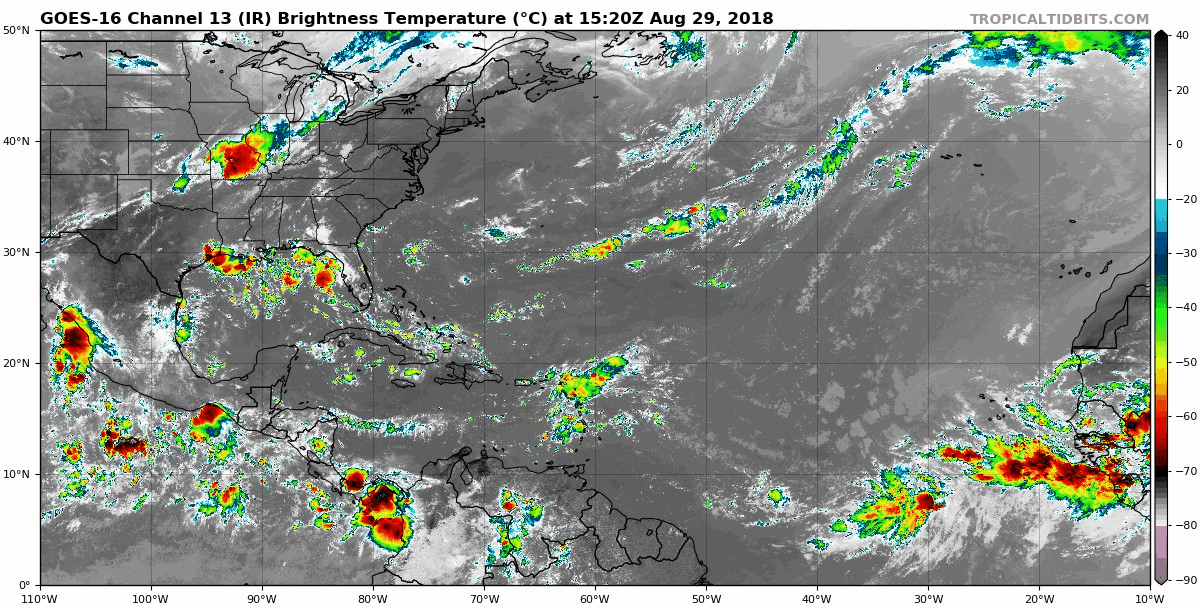
761
AXNT20 KNHC 291750
TWDAT

Tropical Weather Discussion
NWS National Hurricane Center Miami FL
150 PM EDT Wed Aug 29 2018

Tropical Weather Discussion for North America, Central America
Gulf of Mexico, Caribbean Sea, northern sections of South
America, and Atlantic Ocean to the African coast from the
Equator to 32N. The following information is based on satellite
imagery, weather observations, radar and meteorological analysis.

Based on 1200 UTC surface analysis and satellite imagery through
1730 UTC.

...TROPICAL WAVES...

An Atlantic Ocean tropical wave is along 31W/32W from 15N
southward. A 1013 mb low pressure center is along the wave near
09N. scattered moderate to widely scattered strong rainshowers
are from 08N to 13N between Africa and 29W. Isolated moderate to
locally strong rainshowers are elsewhere from 07N to 17N between
Africa and 31W.

An Atlantic Ocean-to-Caribbean Sea tropical wave is along 21N58W
16N60W 13N62W 08N62W, ending in Venezuela. Widely scattered
moderate to isolated strong rainshowers from 13N to 20N between
58W and Puerto Rico. Isolated moderate to locally strong
rainshowers are elsewhere from the SE corner of the Caribbean Sea
to 23N in the Atlantic Ocean between 54W and 70W.

A Caribbean Sea tropical wave is along 86W/87W from 22N in the
Yucatan Channel, beyond Central America, into the eastern Pacific
Ocean. Isolated moderate rainshowers are from 18N northward from
the Windward Passage westward.

...MONSOON TROUGH/ITCZ...

The monsoon trough passes through the coastal sections of Senegal
near 16N17W, to 11N25W, to the 1013 mb low pressure center that is
along the 31W/32W tropical wave, 08N38W. The ITCZ continues from
08N38W to 08N49W. widely scattered moderate to isolated strong
rainshowers are from 03N to 10N between 28W and 40W. isolated
moderate rainshowers are elsewhere from 10N southward, mainly
between 40W and 60W.

...DISCUSSION...

GULF OF MEXICO...

A surface trough extends from central Louisiana, to the upper
Texas Gulf coast, to inland south central Texas. Scattered
moderate to isolated/widely scattered strong rainshowers are to
the north of the line from 25N90W to 28N96W from 90W westward.

The upper level inverted trough/cyclonic circulation center from
24 hours ago has moved into Mexico, and now it is along 100W.
Isolated moderate rainshowers are to the west of the line that
runs from 26N95W to 19N92W.

Weak upper level cyclonic wind flow is in the eastern one-third of
the Gulf of Mexico. Widely scattered moderate to isolated strong
rainshowers are from 25N northward from 90W eastward. Isolated
moderate rainshowers are elsewhere from 22N northward in the Gulf
of Mexico.

A weak ridge will dominate the Gulf waters into the weekend and
support gentle to moderate winds. A surface trough will develop
each evening over the Yucatan Peninsula before moving W and
offshore into the SW Gulf overnight. A surge of moderate to fresh
NE to E winds will accompany this trough.

CARIBBEAN SEA...

An upper level east-to-west oriented trough is along 15N/16N from
70W westward to Central America. Upper level cyclonic wind flow
covers the Caribbean Sea from 14N northward from 70W westward.
Isolated moderate rainshowers are in the area of upper level
cyclonic wind flow.

Broad upper level cyclonic wind flow, from a trough, spans the
Caribbean Sea between 60W and 70W. The trough extends from the
Atlantic Ocean, across Puerto Rico to Venezuela. isolated moderate
rainshowers cover the rest of that part of the Caribbean Sea that
is between 60W and 70W. A tropical wave is in the easternmost part
of the Caribbean Sea, with its associated precipitation.

The eastern part of the eastern Pacific monsoon trough is along
09N from 74W in Colombia beyond southern Costa Rica. An upper
level trough extends from southern Nicaragua to Panama. scattered
moderate to strong rainshowers are from 11N southward from 80W and
83W.

Fresh to strong winds will prevail in the south central Caribbean
Sea today, before diminishing from tonight through Saturday.
Gentle to moderate winds will prevail elsewhere.

ATLANTIC OCEAN...

Upper level cyclonic wind flow, with an inverted trough, covers
the Atlantic Ocean from 20N northward from 70W westward. isolated
moderate rainshowers are in the area of cyclonic wind flow.

An upper level trough extends from a 32N40W cyclonic circulation
center, to a second cyclonic circulation center that is near
28N46W, to a third 24N63W cyclonic circulation center, toward the
Windward Passage. Isolated moderate rainshowers are to the NW of
the line that passes through 32N38W to 25N47W to 23N60W to the
Mona Passage.

Surface high pressure will remain centered SW of Bermuda through
the forecast period. Moderate to fresh winds will be S of 24N,
and gentle to moderate winds will be N of 24N. Winds will pulse
to fresh to strong just N of Hispaniola, including the approach
to the Windward Passage, during the evening and overnight hours
through Sunday. A tropical wave moving into the NE Caribbean Sea
and the adjacent Atlantic Ocean today, will produce active
weather as it moves westward across the Lesser Antilles and
Bahamas through Monday.

For additional information please visit
http://www.hurricanes.gov/marine

$$
MT
https://www.nhc.noaa.gov/
----------------------------------------------------------------
Storm Investigation
011
ABNT20 KNHC 291743
TWOAT

Tropical Weather Outlook
NWS National Hurricane Center Miami FL
200 PM EDT Wed Aug 29 2018

For the North Atlantic...Caribbean Sea and the Gulf of Mexico:

A vigorous low pressure area associated with a tropical wave is
forecast to form between the coast of Africa and the Cabo Verde
Islands on Thursday. Conditions appears to be favorable for
development, and a tropical depression could form over the weekend
while the system moves west-northwestward near the Cabo Verde
Islands and the adjacent Atlantic.  This system is expected to bring
rains and gusty winds to those islands in two or three days, and
interests in that region should monitor the progress of this
disturbance.
* Formation chance through 48 hours...low...30 percent.
* Formation chance through 5 days...medium...60 percent.

$$
Forecaster Avila
-----------------------------------------------------------------
African wave has a higher chance for tropical formation but should
stay out over the North Atlantic waters. The system that is forecast
to develop over the Bahamas not very many models other the than the
ECMWF is suggesting development and a track across Florida. I will
continue to monitor but development is still questionable.
Are you Hurricane Ready? RTW

687
AXNT20 KNHC 291205
TWDAT

Tropical Weather Discussion
NWS National Hurricane Center Miami FL
805 AM EDT Wed Aug 29 2018

Tropical Weather Discussion for North America, Central America
Gulf of Mexico, Caribbean Sea, northern sections of South
America, and Atlantic Ocean to the African coast from the
Equator to 32N. The following information is based on satellite
imagery, weather observations, radar and meteorological analysis.

Based on 0600 UTC surface analysis and satellite imagery through
1115 UTC.

...TROPICAL WAVES...

A tropical wave is over the east Atlantic with axis along 32W
between 03N-14N, moving west at 10-15 kt. A 1012 mb low is
embedded on the wave axis near 08N32W. Scattered moderate
convection is from 04N-10N between 29W-36W.

An Atlantic Ocean tropical wave extends it axis from 20N57W to
07N61W, moving west at 10-15 kt. Widely scattered moderate
convection is over the northern portion of the wave from 13N-20N
between 54W-64W, over the Leeward Islands.

A tropical wave is moving across the west Caribbean with axis
along 86W between 03N-21N, moving west at 10-15 kt. Isolated
moderate convection is over the NW Caribbean and Central America.

...MONSOON TROUGH/ITCZ...

The monsoon trough passes through the coastal sections of Senegal
near 15N17W to 09N26W to a 1012 mb low near 08N32W to 08N39W. The
ITCZ continues from that point to 06N45W to 08N51W. Aside from
the convection related to the tropical waves, scattered moderate
to isolated strong convection is alongthe coast of W Africa from
08N-14N. Isolated moderate convection is from 06N-10N between
42W-48W.

...DISCUSSION...

GULF OF MEXICO...

An upper-level low is in the NE corner of Mexico near 26N100W.
Cyclonic flow covers Texas and N Mexico and the W Gulf of Mexico
N of 20N and W of 94W. Isolated moderate convection is over the
area. Another small upper level low is centered over the NE Gulf
near 30N88W. Scattered showers are over the E Gulf, Florida, and W
Cuba. At the surface, a ridge prevails across the basin along 30N
with 10 kt SE return flow.

A surface trough will develop each night over the Yucatan
Peninsula, then push offshore into the Bay of Campeche with
convection. A surge of moderate to fresh NE to E winds will
accompany this trough. A surface ridge will continue to dominate
the reminder of the Gulf waters, supporting gentle to moderate
winds.

CARIBBEAN SEA...

A tropical wave is moving across the west Caribbean, and another
tropical wave has entered the E Caribbean. Refer to the section
above for details. An upper level low is centered over Jamaica
near 18N77W. This feature is producing isolated moderate
convection over Jamaica and E Cuba. Elsewhere, scattered moderate
to strong convection is over the SW Caribbean S of 10N to include
N Colombia, Panama, and Costa Rica.

Fresh to strong winds will develop each night in the south
central Caribbean Sea just north of Colombia. Gentle to moderate
winds will prevail elsewhere.

ATLANTIC OCEAN...

A tropical wave with an embedded low is moving across the basin.
Refer to the section above for details. An upper-level low is
centered over the central Atlantic near 26N60W. Scattered showers
are within 300 nm of the center. On the surface, a trough is over
the W Atlantic from 30N80W to 25N80W. Scattered showers are noted
within 120 nm of the trough. A 1022 mb high is over the W Atlantic
near 29N67W. To the east, another 1025 mb high is centered near
37N22W.

Surface ridging will prevail through the forecast period. Expect
moderate to fresh winds S of 24N, and gentle to moderate winds N
of 24N. The wind speeds will pulse to fresh to strong just N of
Hispaniola at night through the weekend.

For additional information please visit
http://www.hurricanes.gov/marine

$$
Formosa
https://www.nhc.noaa.gov/
-----------------------------------------------------------------
Storm Investigation
107
ABNT20 KNHC 291129
TWOAT

Tropical Weather Outlook
NWS National Hurricane Center Miami FL
800 AM EDT Wed Aug 29 2018

For the North Atlantic...Caribbean Sea and the Gulf of Mexico:

A low pressure area is forecast to form between the coast of Africa
and the Cabo Verde Islands in association with a tropical wave that
is expected to move off the west coast of Africa late Thursday or
early Friday.  Additional development is anticipated, and a tropical
depression could form over the weekend while the system moves
west-northwestward near the Cabo Verde Islands. Interests in those
islands should monitor the progress of this system.
* Formation chance through 48 hours...low...10 percent.
* Formation chance through 5 days...medium...50 percent.

$$
Forecaster Avila
-------------------------------------------------------------------
Still monitoring the African coast for waves with potential for
development. Also off east of Florida since the EURO model still
suggesting development over the Bahamas...RTW


194
AXNT20 KNHC 281655
TWDAT

Tropical Weather Discussion
NWS National Hurricane Center Miami FL
1255 PM EDT Tue Aug 28 2018

Tropical Weather Discussion for North America, Central America
Gulf of Mexico, Caribbean Sea, northern sections of South
America, and Atlantic Ocean to the African coast from the
Equator to 32N. The following information is based on satellite
imagery, weather observations, radar and meteorological analysis.

Based on 1200 UTC surface analysis and satellite imagery through
1630 UTC.

...TROPICAL WAVES...

An Atlantic Ocean tropical wave is along 19W/20W from 20N
southward. Isolated moderate rainshowers are from 05N to 19N
between Africa and 23W.

An Atlantic Ocean tropical wave is along 26W/27W from 20N
southward. Widely scattered moderate to isolated strong
rainshowers are from 07N to 12N between 26W and 30W. Isolated
moderate to locally strong rainshowers are elsewhere from 04N to
13N between 20W and 30W. Rainshowers are possible in the remainder
of the area from 19N southward from 44W eastward.

An Atlantic Ocean tropical wave is along 52W/53W from 20N
southward. Isolated moderate rainshowers are from 10N to 20N
between 43W and 60W.

A Caribbean Sea tropical wave is along 68W/69W from 21N
southward, through the Mona Passage/eastern sections of the
Dominican Republic to Venezuela. Upper level cyclonic wind flow
covers the Atlantic Ocean from 20N to 27N between 60W and 70W.
Isolated moderate rainshowers are from 16N to 26N between 60W and
70W.

A tropical wave is along 88W/89W from 22N southward, from the
Yucatan Peninsula through Belize, Guatemala, and El Salvador, into
the eastern Pacific Ocean. Isolated moderate rainshowers are
within 90 nm on either side of the tropical wave.

...MONSOON TROUGH/ITCZ...

The monsoon trough passes through the coastal sections of Senegal
near 14N17W, to 10N24W, 08N32W, and 09N41W. The ITCZ is not
discernible. Isolated moderate to locally strong rainshowers are
cover the area from 04N to 13N between 20W and 30W. Isolated
moderate rainshowers cover the rest of the area from 19N
southward from 60W eastward.

...DISCUSSION...

GULF OF MEXICO...

An upper level inverted trough is in the N central part of the
Gulf of Mexico. Cyclonic wind flow covers the NE corner of the
area. isolated moderate rainshowers are from 90W eastward.

An upper level cyclonic circulation center is in the NE corner of
Mexico. Cyclonic wind flow covers Texas and Mexico and the coastal
waters from 20N northward from 92W westward. isolated moderate
rainshowers cover the Gulf waters from 90W westward. 24-hour
rainfall totals that are listed for the period that ended at
28/1200 UTC...according to the PAN AMERICAN TEMPERATURE AND
PRECIPITATION TABLES...MIATPTPAN/SXCA01 KNHC...are 1.21 in
Veracruz in Mexico.

A surface trough will develop each evening in the Yucatan
Peninsula, before pushing offshore into the SW Gulf of Mexico. A
surge of moderate to fresh NE to E winds will accompany this
trough. A surface ridge will dominate the rest of the Gulf waters,
supporting gentle to moderate winds.

CARIBBEAN SEA...

An upper level cyclonic circulation center is about 150 nm to the
south of Cuba, in the NW corner of the Caribbean Sea. Isolated
moderate rainshowers are from 16N northward from 70W westward.

The eastern part of the eastern Pacific monsoon trough is along
09N from 74W in Colombia beyond southern Costa Rica. An upper
level trough extends from southern Nicaragua to Panama. scattered
moderate to strong rainshowers are from 12N southward from 81W
westward to land.

Fresh to strong winds will prevail in the south central Caribbean
Sea through Wednesday before diminishing. Gentle to moderate
winds will prevail elsewhere.

ATLANTIC OCEAN...

Upper level cyclonic wind flow, with an inverted trough, covers
the Atlantic Ocean from 20N northward from 70W westward. isolated
moderate rainshowers are in the area of cyclonic wind flow.

An upper level trough extends from a 33N32W cyclonic circulation
center, to a second cyclonic circulation center that is near
28N44W. The trough continues to a third upper level cyclonic
circulation center that is near 23N63W. Isolated moderate
rainshowers are to the NW of the line that passes through 32N30W
to 24N50W to 18N61W.

Surface high pressure will prevail through the forecast period.
Expect moderate to fresh winds S of 24N, and gentle to moderate
winds N of 24N. The wind speeds will pulse to fresh to strong
just N of Hispaniola at night through Saturday.

For additional information please visit
http://www.hurricanes.gov/marine

$$
MT
https://www.nhc.noaa.gov/
---------------------------------------------------------------
Storm Investigation
742
ABNT20 KNHC 281718
TWOAT

Tropical Weather Outlook
NWS National Hurricane Center Miami FL
200 PM EDT Tue Aug 28 2018

For the North Atlantic...Caribbean Sea and the Gulf of Mexico:

A tropical wave is forecast to move off the west coast of Africa on
Thursday.  Some development of this system is possible over the
weekend while it moves westward across the eastern tropical Atlantic
Ocean.
* Formation chance through 48 hours...low...near 0 percent.
* Formation chance through 5 days...low...20 percent.

$$
Forecaster Avila
----------------------------------------------------------------
Monitoring the coast of Africa, the Central Atlantic and the
Bahamas over the weekend for tropical cyclone formation...RTW
https://ralphstropicalweather.com/


