Thanks for your patience
RTW

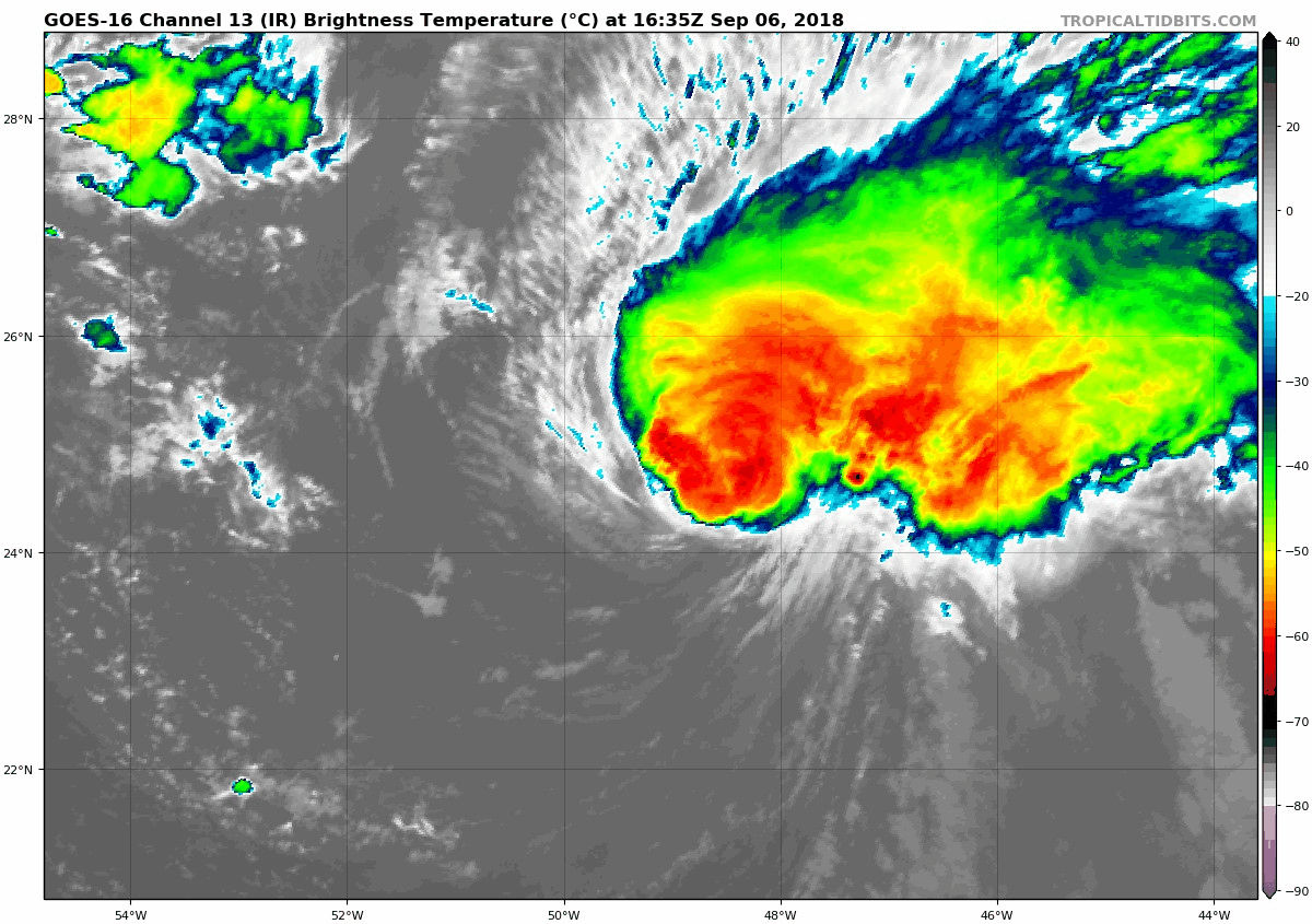
218
WTNT31 KNHC 062043
TCPAT1

BULLETIN
Hurricane Florence Advisory Number  30
NWS National Hurricane Center Miami FL       AL062018
500 PM AST Thu Sep 06 2018

...FLORENCE CLINGING TO HURRICANE STATUS...
...EXPECTED TO REINTENSIFY ON FRIDAY...


SUMMARY OF 500 PM AST...2100 UTC...INFORMATION
----------------------------------------------
LOCATION...25.0N 49.6W
ABOUT 985 MI...1585 KM ENE OF THE NORTHERN LEEWARD ISLANDS
ABOUT 1050 MI...1685 KM ESE OF BERMUDA
MAXIMUM SUSTAINED WINDS...80 MPH...130 KM/H
PRESENT MOVEMENT...NW OR 305 DEGREES AT 10 MPH...17 KM/H
MINIMUM CENTRAL PRESSURE...989 MB...29.21 INCHES


WATCHES AND WARNINGS
--------------------
There are no coastal watches or warnings in effect.


DISCUSSION AND OUTLOOK
----------------------
At 500 PM AST (2100 UTC), the center of Hurricane Florence was
located near latitude 25.0 North, longitude 49.6 West. Florence is
moving toward the northwest near 10 mph (17 km/h), and a turn
towards the west is expected tomorrow.  A westward to
west-northwestward motion should continue into early next week.

Maximum sustained winds are near 80 mph (130 km/h) with higher
gusts.  Continued weakening is forecast during the next day or so
followed by restrengthening late Friday into this weekend.

Hurricane-force winds extend outward up to 15 miles (30 km) from the
center and tropical-storm-force winds extend outward up to 90 miles
(150 km).

The estimated minimum central pressure is 989 mb (29.21 inches).


HAZARDS AFFECTING LAND
----------------------
SURF:  Swells generated by Florence will begin to affect Bermuda on
Friday and will reach portions of the U.S. East Coast over the
weekend.  These swells are likely to cause life-threatening surf and
rip current conditions.  Please consult products from your local
weather office.


NEXT ADVISORY
-------------
Next complete advisory at 1100 PM AST.

$$
Forecaster Berg/Rhome
https://www.nhc.noaa.gov/
--------------------------------------------------------------------

636
WTNT31 KNHC 061438
TCPAT1

BULLETIN
Hurricane Florence Advisory Number  29
NWS National Hurricane Center Miami FL       AL062018
1100 AM AST Thu Sep 06 2018

...FLORENCE WEAKENS FURTHER...


SUMMARY OF 1100 AM AST...1500 UTC...INFORMATION
-----------------------------------------------
LOCATION...24.6N 48.6W
ABOUT 1030 MI...1660 KM ENE OF THE NORTHERN LEEWARD ISLANDS
ABOUT 1115 MI...1795 KM ESE OF BERMUDA
MAXIMUM SUSTAINED WINDS...105 MPH...165 KM/H
PRESENT MOVEMENT...NW OR 315 DEGREES AT 10 MPH...17 KM/H
MINIMUM CENTRAL PRESSURE...975 MB...28.80 INCHES


WATCHES AND WARNINGS
--------------------
There are no coastal watches or warnings in effect.


DISCUSSION AND OUTLOOK
----------------------
At 1100 AM AST (1500 UTC), the center of Hurricane Florence was
located near latitude 24.6 North, longitude 48.6 West.  Florence is
moving toward the northwest near 10 mph (17 km/h).  A turn toward
the west-northwest and west with a decrease in forward speed is
expected through Saturday.  Florence may begin to move faster toward
the west-northwest over the western Atlantic early next week.

Maximum sustained winds have decreased to near 105 mph (165 km/h)
with higher gusts.  Additional weakening is forecast during the
next day or two.  However, Florence is expected to remain a
hurricane and likely reintensify over the weekend.

Hurricane-force winds extend outward up to 15 miles (30 km) from the
center, and tropical-storm-force winds extend outward up to 90 miles
(150 km).

The estimated minimum central pressure is 975 mb (28.80 inches).


HAZARDS AFFECTING LAND
----------------------
SURF:  Swells generated by Florence will begin to affect Bermuda on
Friday and will reach portions of the U.S. East Coast over the
weekend.  These swells are likely to cause life-threatening surf and
rip current conditions.  Please consult products from your local
weather office.


NEXT ADVISORY
-------------
Next complete advisory at 500 PM AST.

$$
Forecaster Berg
https://www.nhc.noaa.gov/
--------------------------------------------------------------------


Florence forecast to regain cat 3 status!


944
WTNT31 KNHC 052032
TCPAT1

BULLETIN
Hurricane Florence Advisory Number  26
NWS National Hurricane Center Miami FL       AL062018
500 PM AST Wed Sep 05 2018

...FLORENCE STRENGTHENS INTO A CATEGORY 4 HURRICANE...


SUMMARY OF 500 PM AST...2100 UTC...INFORMATION
----------------------------------------------
LOCATION...22.7N 46.6W
ABOUT 1110 MI...1790 KM ENE OF THE NORTHERN LEEWARD ISLANDS
ABOUT 1295 MI...2080 KM ESE OF BERMUDA
MAXIMUM SUSTAINED WINDS...130 MPH...215 KM/H
PRESENT MOVEMENT...NW OR 305 DEGREES AT 13 MPH...20 KM/H
MINIMUM CENTRAL PRESSURE...953 MB...28.15 INCHES


WATCHES AND WARNINGS
--------------------
There are no coastal watches or warnings in effect.


DISCUSSION AND OUTLOOK
----------------------
At 500 PM AST (2100 UTC), the eye of Hurricane Florence was located
near latitude 22.7 North, longitude 46.6 West. Florence is moving
toward the northwest near 13 mph (20 km/h), and this general motion
is expected to continue through Thursday.  A turn toward the
west-northwest with a decrease in forward speed is forecast to begin
Thursday night, followed by a turn back toward the northwest early
next week.

Maximum sustained winds have increased to near 130 mph (215 km/h)
with higher gusts.  Florence is now a category 4 hurricane on the
Saffir-Simpson Hurricane Wind Scale.  Some weakening is forecast
during the next couple of days, but Florence is expected to remain
a powerful hurricane through early next week.

Hurricane-force winds extend outward up to 15 miles (30 km) from the
center and tropical-storm-force winds extend outward up to 90 miles
(150 km).

The estimated minimum central pressure is 953 mb (28.15 inches).


HAZARDS AFFECTING LAND
----------------------
SURF:  Swells generated by Florence will begin to affect Bermuda on
Friday.  These swells are likely to cause life-threatening surf and
rip current conditions.  Please consult products from your local
weather office.


NEXT ADVISORY
-------------
Next complete advisory at 1100 PM AST.

$$
Forecaster Berg/Rhome
--------------------------------------------------------------------
INVEST 92L AND STORM INVEST ABOUT TO EMERGE THE AFRICAN COAST
468
ABNT20 KNHC 051742
TWOAT

Tropical Weather Outlook
NWS National Hurricane Center Miami FL
200 PM EDT Wed Sep 5 2018

For the North Atlantic...Caribbean Sea and the Gulf of Mexico:

The National Hurricane Center is issuing advisories on Hurricane
Florence, located over the east-central tropical Atlantic Ocean,
and has issued its last advisory on Tropical Depression Gordon,
located over west central Mississippi.  Future information on
Gordon can be found in Public Advisories issued by the Weather
Prediction Center.

Shower activity associated with a broad area of low pressure
centered a couple of hundred miles south-southwest of the Cabo Verde
Islands is gradually becoming better organized.  Environmental
conditions are forecast to be conducive for additional development,
and a tropical depression is expected to form during the next
couple of days while the system moves west-northwestward across the
tropical Atlantic Ocean.
* Formation chance through 48 hours...high...70 percent.
* Formation chance through 5 days...high...90 percent.

A tropical wave is forecast to move off the west coast of Africa
in a few days.  Some development of the system is possible over the
weekend while the wave moves westward over the far eastern
tropical Atlantic Ocean.
* Formation chance through 48 hours...low...near 0 percent.
* Formation chance through 5 days...low...30 percent.

&&
Public Advisories on Gordon are issued by the Weather Prediction
Center under AWIPS header TCPAT2, WMO header WTNT32 KWNH, and on the
web at http://www.wpc.ncep.noaa.gov.

$$
Forecaster Beven
https://www.nhc.noaa.gov/
--------------------------------------------------------------------


VISIBLE SATELLITE

COLOR SATELLITE CLOUD TEMPERATURE


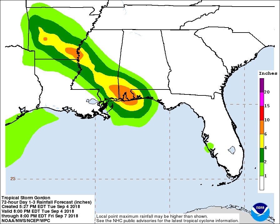
227
WTNT32 KNHC 051431
TCPAT2

BULLETIN
Tropical Depression Gordon Advisory Number  13
NWS National Hurricane Center Miami FL       AL072018
1000 AM CDT Wed Sep 05 2018

...GORDON CONTINUES TO WEAKEN OVER CENTRAL MISSISSIPPI...
...THREAT OF HEAVY RAINS AND FLOODING WILL CONTINUE FOR SEVERAL
DAYS...


SUMMARY OF 1000 AM CDT...1500 UTC...INFORMATION
-----------------------------------------------
LOCATION...32.3N 90.2W
ABOUT 5 MI...10 KM W OF JACKSON MISSISSIPPI
MAXIMUM SUSTAINED WINDS...30 MPH...45 KM/H
PRESENT MOVEMENT...NW OR 320 DEGREES AT 14 MPH...22 KM/H
MINIMUM CENTRAL PRESSURE...1008 MB...29.77 INCHES


WATCHES AND WARNINGS
--------------------
There are no coastal watches or warnings in effect.

For more information on Gordon, please see products issued by your
local National Weather Service office.


DISCUSSION AND OUTLOOK
----------------------
At 1000 AM CDT (1500 UTC), the center of Tropical Depression Gordon
was located near latitude 32.3 North, longitude 90.2 West.  The
depression is moving toward the northwest near 14 mph (22 km/h).  A
northwestward motion with a decrease in forward speed is expected
over the next couple of days.  On the forecast track, the center of
Gordon will move across the lower Mississippi Valley today and
tonight.  A turn toward the north-northwest and north is forecast to
occur on Friday.

Maximum sustained winds have decreased to near 30 mph (45 km/h) with
higher gusts.  Additional weakening is expected as Gordon moves
farther inland.  Jackson, Mississippi, recently reported a wind gust
of 35 mph (55 km/h).

The estimated minimum central pressure is 1008 mb (29.77 inches).


HAZARDS AFFECTING LAND
----------------------
RAINFALL:  Gordon is expected to produce total rain accumulations of
4 to 8 inches over the western Florida Panhandle, southwest Alabama,
central Mississippi, Arkansas, Missouri, southern Iowa and Illinois,
with isolated maximum amounts of 12 inches through early Saturday.
This rainfall will cause flash flooding across portions of these
areas.

WIND:  Wind gusts to tropical storm force could occur in showers
and thunderstorms associated with Gordon today.

TORNADOES:  A tornado or two is possible through this evening over
Mississippi and western Alabama.

STORM SURGE:  Water levels along the northern Gulf of Mexico coast
will gradually subside later today.


NEXT ADVISORY
-------------
This is the last public advisory issued by the National Hurricane
Center on Gordon.  Future information on Gordon can be found in
Public Advisories issued by the Weather Prediction Center beginning
at 4 PM CDT, under AWIPS header TCPAT2, WMO header WTNT32 KWNH, and
on the web at https://www.wpc.ncep.noaa.gov.

$$
Forecaster Beven
--------------------------------------------------------------------
FLORENCE UPDATE BY NHC
438
WTNT31 KNHC 051439
TCPAT1

BULLETIN
Hurricane Florence Advisory Number  25
NWS National Hurricane Center Miami FL       AL062018
1100 AM AST Wed Sep 05 2018

...FLORENCE FLOURISHING IN THE FACE OF SOUTHWESTERLY SHEAR...


SUMMARY OF 1100 AM AST...1500 UTC...INFORMATION
-----------------------------------------------
LOCATION...22.0N 45.7W
ABOUT 1160 MI...1865 KM ENE OF THE NORTHERN LEEWARD ISLANDS
ABOUT 1370 MI...2205 KM ESE OF BERMUDA
MAXIMUM SUSTAINED WINDS...125 MPH...205 KM/H
PRESENT MOVEMENT...NW OR 305 DEGREES AT 13 MPH...20 KM/H
MINIMUM CENTRAL PRESSURE...957 MB...28.26 INCHES


WATCHES AND WARNINGS
--------------------
There are no coastal watches or warnings in effect.


DISCUSSION AND OUTLOOK
----------------------
At 1100 AM AST (1500 UTC), the eye of Hurricane Florence was
located near latitude 22.0 North, longitude 45.7 West.  Florence is
moving toward the northwest near 13 mph (20 km/h), and this general
motion is expected to continue through tonight.  A turn toward the
west-northwest with a decrease in forward speed is forecast on
Thursday, followed by a turn back toward the northwest early next
week.

Satellite images indicate that maximum sustained winds have
increased to near 125 mph (205 km/h) with higher gusts.  Florence is
a category 3 hurricane on the Saffir-Simpson Hurricane Wind Scale.
Some weakening is possible during the next few days, but Florence is
expected to remain a strong hurricane through early next week.

Hurricane-force winds extend outward up to 15 miles (30 km) from the
center, and tropical-storm-force winds extend outward up to 90 miles
(150 km).

The estimated minimum central pressure is 957 mb (28.26 inches).


HAZARDS AFFECTING LAND
----------------------
None.


NEXT ADVISORY
-------------
Next complete advisory at 500 PM AST.

$$
Forecaster Berg/Rhome
https://www.nhc.noaa.gov/
---------------------------------------------------------------------


057
WTNT32 KNHC 050256
TCPAT2

BULLETIN
Tropical Storm Gordon Advisory Number  11
NWS National Hurricane Center Miami FL       AL072018
1000 PM CDT Tue Sep 04 2018

...CENTER OF GORDON MAKING LANDFALL JUST WEST OF THE
ALABAMA-MISSISSIPPI BORDER...


SUMMARY OF 1000 PM CDT...0300 UTC...INFORMATION
-----------------------------------------------
LOCATION...30.3N 88.4W
ABOUT 30 MI...50 KM ESE OF BILOXI MISSISSIPPI
ABOUT 35 MI...55 KM SSW OF MOBILE ALABAMA
MAXIMUM SUSTAINED WINDS...70 MPH...110 KM/H
PRESENT MOVEMENT...NW OR 315 DEGREES AT 14 MPH...22 KM/H
MINIMUM CENTRAL PRESSURE...997 MB...29.44 INCHES


WATCHES AND WARNINGS
--------------------
CHANGES WITH THIS ADVISORY:

All warnings and watches west of the mouth of the Pearl River have
been discontinued.  The Storm Surge Warning west of Biloxi has
also been discontinued.

SUMMARY OF WATCHES AND WARNINGS IN EFFECT:

A Storm Surge Warning is in effect for...
* Biloxi Mississippi to Dauphin Island

A Storm Surge Watch is in effect for...
* East of Dauphin Island to Navarre

A Hurricane Warning is in effect for...
* Mouth of the Pearl River to the Alabama-Florida Border

A Tropical Storm Warning is in effect for...
* Alabama-Florida Border to Okaloosa-Walton County Line

A Storm Surge Warning means there is a danger of life-threatening
inundation, from rising water moving inland from the coastline,
in the indicated locations. For a depiction of areas at risk, please
see the National Weather Service Storm Surge Watch/Warning Graphic,
available at hurricanes.gov. This is a life-threatening situation.
Persons located within these areas should take all necessary actions
to protect life and property from rising water and the potential for
other dangerous conditions. Promptly follow evacuation and other
instructions from local officials.

A Hurricane Warning means that hurricane conditions are expected
somewhere within the warning area.

A Tropical Storm Warning means that tropical storm conditions are
expected somewhere within the warning areas.

For storm information specific to your area, including possible
inland watches and warnings, please monitor products issued by your
local National Weather Service forecast office.


DISCUSSION AND OUTLOOK
----------------------
At 1000 PM CDT (0300 UTC), the center of Tropical Storm Gordon was
located near latitude 30.3 North, longitude 88.4 West. Gordon is
moving toward the northwest near 14 mph (22 km/h).  A
northwestward motion with some decrease in forward speed is
expected over the next couple of days. On the forecast track, the
center of Gordon will move inland across the lower Mississippi
Valley through Wednesday.  A turn toward the north-northwest
and north is forecast to occur on Friday.

Maximum sustained winds are near 70 mph (110 km/h) with higher
gusts.  Rapid weakening is forecast after Gordon moves inland, and
Gordon is forecast to become a tropical depression on Wednesday.

Tropical-storm-force winds extend outward up to 80 miles (130 km)
from the center.  A NOAA Coastal Marine Observing site on Dauphin
Island, Alabama has measured a sustained wind of 57 mph (91 km/h)
with a gust to 72 mph (117 km/h). A wind gust of 61 mph (98 km/h)
was recently observed at the Pensacola Naval Air Station.

The latest minimum central pressure estimated from NOAA Hurricane
Hunter aircraft data is 997 mb (29.44 inches).


HAZARDS AFFECTING LAND
----------------------
STORM SURGE:  The combination of a dangerous storm surge and the
tide will cause normally dry areas near the coast to be flooded by
rising waters moving inland from the shoreline. The water could
reach the following heights above ground somewhere in the indicated
areas if the peak surge occurs at the time of high tide...

Mouth of the Mississippi River to Biloxi...1 to 3 ft.
Biloxi to the Alabama/Florida Border including Mobile Bay...2 to
4 ft.
Alabama/Florida Border to Navarre, Florida...1 to 3 ft.

The deepest water will occur along the immediate coast near and to
the east of the landfall location, where the surge will be
accompanied by large waves. Surge-related flooding depends on the
relative timing of the surge and the tidal cycle, and can vary
greatly over short distances. For information specific to your area,
please see products issued by your local National Weather Service
forecast office.

RAINFALL:  Gordon is expected to produce total rain accumulations of
4 to 8 inches over the western Florida Panhandle, southwest Alabama,
southern and central Mississippi, northeastern Louisiana, and
southern Arkansas, with isolated maximum amounts of 12 inches
through late Thursday. This rainfall will cause flash flooding
across portions of these areas.

WIND:  Tropical storm and hurricane conditions will continue to
spread onshore during the next several hours within portions of the
warning area.

TORNADOES:  A couple of tornadoes are possible tonight near the
coasts of Alabama and the western Florida Panhandle.


NEXT ADVISORY
-------------
Next intermediate advisory at 100 AM CDT.
Next complete advisory at 400 AM CDT.

$$
Forecaster Brown
--------------------------------------------------------------------


775
WTNT32 KNHC 042041
TCPAT2

BULLETIN
Tropical Storm Gordon Advisory Number  10
NWS National Hurricane Center Miami FL       AL072018
400 PM CDT Tue Sep 04 2018

...GORDON STRENGTHENS A LITTLE AS IT HEADS TOWARD THE NORTH-CENTRAL
GULF COAST...


SUMMARY OF 400 PM CDT...2100 UTC...INFORMATION
----------------------------------------------
LOCATION...29.4N 87.8W
ABOUT 95 MI...155 KM SE OF BILOXI MISSISSIPPI
ABOUT 90 MI...145 KM S OF MOBILE ALABAMA
MAXIMUM SUSTAINED WINDS...70 MPH...110 KM/H
PRESENT MOVEMENT...NW OR 310 DEGREES AT 15 MPH...24 KM/H
MINIMUM CENTRAL PRESSURE...1000 MB...29.53 INCHES


WATCHES AND WARNINGS
--------------------
CHANGES WITH THIS ADVISORY:

The Tropical Storm Warning has been discontinued west of the Mouth
of the Mississippi River, including Lake Maurepas.

SUMMARY OF WATCHES AND WARNINGS IN EFFECT:

A Storm Surge Warning is in effect for...
* Shell Beach to Dauphin Island

A Storm Surge Watch is in effect for...
* West of Shell Beach to the Mouth of the Mississippi River
* East of Dauphin Island to Navarre

A Hurricane Warning is in effect for...
* Mouth of the Pearl River to the Alabama-Florida Border

A Tropical Storm Warning is in effect for...
* West of the Mouth of the Pearl River to the Mouth of the
Mississippi River, including Lake Pontchartrain
* Alabama-Florida Border to Okaloosa-Walton County Line

A Storm Surge Warning means there is a danger of life-threatening
inundation, from rising water moving inland from the coastline,
in the indicated locations. For a depiction of areas at risk, please
see the National Weather Service Storm Surge Watch/Warning Graphic,
available at hurricanes.gov. This is a life-threatening situation.
Persons located within these areas should take all necessary actions
to protect life and property from rising water and the potential for
other dangerous conditions. Promptly follow evacuation and other
instructions from local officials.

A Storm Surge Watch means there is a possibility of life-
threatening inundation, from rising water moving inland from the
coastline, in the indicated locations.

A Hurricane Warning means that hurricane conditions are expected
somewhere within the warning area. Preparations to protect life
and property should be rushed to completion.

A Tropical Storm Warning means that tropical storm conditions are
expected somewhere within the warning areas.

For storm information specific to your area, including possible
inland watches and warnings, please monitor products issued by your
local National Weather Service forecast office.


DISCUSSION AND OUTLOOK
----------------------
At 400 PM CDT (2100 UTC), the center of Tropical Storm Gordon was
located by NOAA Doppler weather radars near latitude 29.4 North,
longitude 87.8 West. Gordon is moving toward the northwest near 15
mph (24 km/h) and this general motion is expected to continue until
landfall occurs tonight along the north-central Gulf coast. A
northwestward motion with some decrease in forward speed is expected
after landfall, with a gradual turn toward the north-northwest and
north forecast to occur on Friday. On the forecast track, the center
of Gordon will make landfall along the north-central Gulf Coast
within the hurricane warning area this evening or tonight, and then
move inland over the lower Mississippi Valley through Wednesday.

Data from NOAA Doppler weather radars indicate that maximum
sustained winds have increased to near 70 mph (110 km/h) with
higher gusts. Some additional strengthening is still possible, and
Gordon could become a hurricane before landfall occurs along the
north-central Gulf Coast this evening. Rapid weakening is forecast
after Gordon moves inland.

Tropical-storm-force winds extend outward up to 80 miles (130 km)
from the center.

The estimated minimum central pressure is 1000 mb (29.53 inches).


HAZARDS AFFECTING LAND
----------------------
STORM SURGE:  The combination of a dangerous storm surge and the
tide will cause normally dry areas near the coast to be flooded by
rising waters moving inland from the shoreline. The water could
reach the following heights above ground somewhere in the indicated
areas if the peak surge occurs at the time of high tide...

Mouth of the Pearl River to Dauphin Island...3 to 5 ft.
Navarre Florida to Dauphin Island, including Mobile Bay...2 to 4 ft.
Mouth of the Pearl River to the Mouth of Mississippi River...2 to 4
ft.

The deepest water will occur along the immediate coast near and to
the east of the landfall location, where the surge will be
accompanied by large waves. Surge-related flooding depends on the
relative timing of the surge and the tidal cycle, and can vary
greatly over short distances. For information specific to your area,
please see products issued by your local National Weather Service
forecast office.

RAINFALL:  Gordon is expected to produce total rain accumulations of
4 to 8 inches over the western Florida Panhandle, southwest Alabama,
southern and central Mississippi, northeastern Louisiana, and
southern Arkansas, with isolated maximum amounts of 12 inches
through late Thursday. This rainfall will cause flash flooding
across portions of these areas.

WIND:  Tropical storm conditions will spread onshore within portions
of the warning area during the next few hours, with hurricane
conditions expected by this evening in the hurricane warning area.

TORNADOES:  A couple of tornadoes are possible through tonight
near the coasts of Mississippi, Alabama, and the Florida Panhandle.


NEXT ADVISORY
-------------
Next intermediate advisory at 700 PM CDT.
Next complete advisory at 1000 PM CDT.

$$
Forecaster Stewart
---------------------------------------------------------------------
158
WTNT31 KNHC 042031
TCPAT1

BULLETIN
Hurricane Florence Advisory Number  22
NWS National Hurricane Center Miami FL       AL062018
500 PM AST Tue Sep 04 2018

...FLORENCE STRONGER THAN ANTICIPATED...
...STILL NO THREAT TO LAND THROUGH THE WEEKEND...


SUMMARY OF 500 PM AST...2100 UTC...INFORMATION
----------------------------------------------
LOCATION...20.3N 43.2W
ABOUT 1305 MI...2100 KM E OF THE NORTHERN LEEWARD ISLANDS
MAXIMUM SUSTAINED WINDS...85 MPH...140 KM/H
PRESENT MOVEMENT...WNW OR 300 DEGREES AT 12 MPH...19 KM/H
MINIMUM CENTRAL PRESSURE...984 MB...29.06 INCHES


WATCHES AND WARNINGS
--------------------
There are no coastal watches or warnings in effect.


DISCUSSION AND OUTLOOK
----------------------
At 500 PM AST (2100 UTC), the center of Hurricane Florence was
located near latitude 20.3 North, longitude 43.2 West.  Florence is
moving toward the west-northwest near 12 mph (19 km/h), and this
general motion is expected to continue through Wednesday night.  A
northwestward motion is expected to begin by Thursday with
Florence's forward speed decreasing by the weekend.

Maximum sustained winds have increased to near 85 mph (140 km/h)
with higher gusts.  Some additional strengthening is possible
through tonight, but Florence is expected to weaken beginning on
Wednesday and continuing through Friday.

Hurricane-force winds extend outward up to 15 miles (30 km) from the
center, and tropical-storm-force winds extend outward up to 105
miles (165 km).

The estimated minimum central pressure is 984 mb (29.06 inches).


HAZARDS AFFECTING LAND
----------------------
None.


NEXT ADVISORY
-------------
Next complete advisory at 1100 PM AST.

$$
Forecaster Berg

https://www.nhc.noaa.gov/
---------------------------------------------------------------------