Wednesday, June 26, 2024

..TRACKING THE TROPICS UPDATE JUNE 26, 2024 1155 AM EDT..


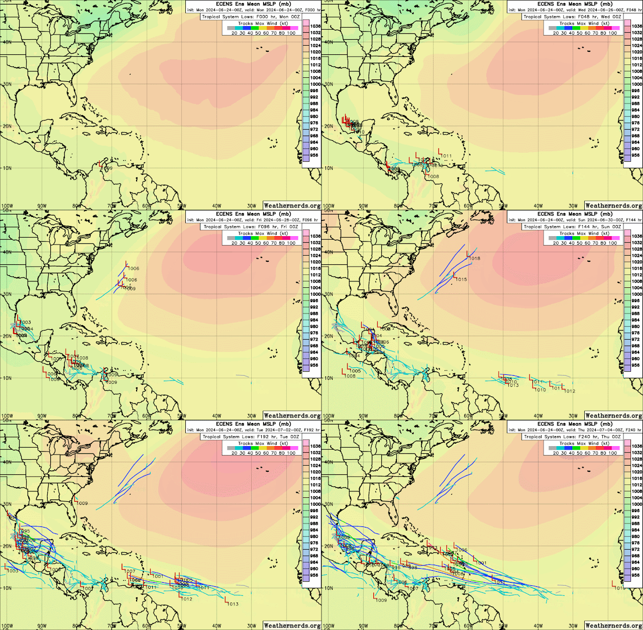
I have been reviewing the models this morning in reference to the storm investigation in the Atlantic, and the Ensemble models are still showing something, maybe tracking into the east Caribbean. However, it is still too soon to tell if anything will develop and make it into the Caribbean without having any difficulties with upper-level wind shear and Saharan dry air and dust.

The EURO, which showed low pressure or a storm moving over Puerto Rico, is no longer hinting at that. As in yesterday's tropic update, the forecast is subject to change, so I will monitor it, report accordingly, and post it here. 

As it is right now, we have not seen a full-fledged La Niña, so we remain in neutral conditions for now. 

Also, the sea surface temperatures have cooled in the tropical Atlantic to 26 Celsius between 25° west and 0° west and seem to be cooling westward as you watch the animation, which I am unable to post here. However, the image below shows the yellows, which range between 25 and 26 degrees Celsius. It's still too early for the Atlantic, though. August–September is climatologically the month where the Atlantic is the warmest and storms begin to form off the coast of Africa.

So I will continue to monitor, and I will report as updates come in from NHC and as I see something that catches my attention.

RTW


ZCZC MIATWOAT ALL
TTAA00 KNHC DDHHMM

Tropical Weather Outlook
NWS National Hurricane Center Miami FL
800 AM EDT Wed Jun 26 2024

For the North Atlantic...Caribbean Sea and the Gulf of Mexico:

1. Western Caribbean/Southwestern Gulf of Mexico (AL94):
A tropical wave over the central Caribbean Sea is producing
disorganized shower activity while it moves quickly westward at
around 25 mph. Environmental conditions could become more conducive
for some gradual development in a couple of days over the western
Caribbean Sea or over the southwestern Gulf of Mexico during the
weekend.
* Formation chance through 48 hours...low...10 percent.
* Formation chance through 7 days...low...20 percent.
2. Eastern Tropical Atlantic:
A tropical wave located a few hundred miles southwest of the
Cabo Verde Islands is producing disorganized showers and
thunderstorms. Some slow development of this system is possible
during the next several days while it moves generally westward
across the central and western tropical Atlantic at 15 to 20 mph.
* Formation chance through 48 hours...low...near 0 percent.
* Formation chance through 7 days...low...30 percent.

Forecaster Pasch/Roberts


Tuesday, June 25, 2024

..TROPICAL OUTLOOK JUNE 25, 2024 09:18 PM EDT..


The European model is still hinting at development next week, so I will continue to monitor the Atlantic system that I mentioned in the earlier tropical outlook, which is now in the 8 p.m. NHC outlook.

 RTW

1. Western Caribbean/Southwestern Gulf of Mexico (AL94):
A tropical wave located over the southeastern Caribbean Sea is
producing disorganized showers and thunderstorms as it moves quickly
westward at around 25 mph. Environmental conditions could become
more conducive for some gradual development late this week over the
western Caribbean Sea or over the southwestern Gulf of Mexico
during the weekend.
* Formation chance through 48 hours...low...10 percent.
* Formation chance through 7 days...low...20 percent.
2. Eastern Tropical Atlantic:
A tropical wave centered a couple of hundred miles south of the
Cabo Verde Islands is producing disorganized showers and
thunderstorms. Some slow development of this system is possible
this weekend and into early next week while it moves generally
westward across the central and western tropical Atlantic at 15 to
20 mph.
* Formation chance through 48 hours...low...near 0 percent.
* Formation chance through 7 days...low...20 percent.

Forecaster Bucci


..TROPICAL OUTLOOK JUNE 25, 2024..


Been monitoring models and the wave that NHC is monitoring that will more than likely track over Central America and its not a concern for the U.S.  I will monitor it, but the main area that I will be watching is the northern Leeward Islands for possible development the first week of July. 

The Euro models shows a weak storm system moving through the northern Leeward and turning north over Puerto Rico.  Its still a week away so forecast will change from run to run, so all I can do is monitor for now.

Now that we are entering into July it looks like we are beginning to see a gradual change in the trade winds from west to east.  This means more storms tracking into the Caribbean as these waves are not affected by upper level winds from the west. However, we are totally wind shear free, but some areas are more favorable than we have seen in past weeks. 

Ensemble models are also picking up on this change in the trade winds by hinting of possible development.  Once again these are forecast and all subject to change.

RTW

Sahara Dust


---------------------------------------------------------------------------------------------------------------------------------

ZCZC MIATWOAT ALL
TTAA00 KNHC DDHHMM

Tropical Weather Outlook
NWS National Hurricane Center Miami FL
200 PM EDT Tue Jun 25 2024

For the North Atlantic...Caribbean Sea and the Gulf of Mexico:

1. Western Caribbean/Southwestern Gulf of Mexico:
A tropical wave located over the southeastern Caribbean Sea is
producing disorganized showers and thunderstorms as it moves
quickly westward at around 25 mph. Environmental conditions
could support some gradual development once the wave reaches the
western Caribbean Sea late this week, and some development is also
possible over the southwestern Gulf of Mexico during the weekend.
* Formation chance through 48 hours...low...10 percent.
* Formation chance through 7 days...low...20 percent.

Forecaster Hagen/Pasch

----------------------------------------------------------------------------------------------------------------

195 
ACCA62 KNHC 251744
TWOSAT

Perspectiva sobre las Condiciones del Tiempo en el Trópico
Centro Nacional de Huracanes del SNM Miami FL
200 PM EDT martes 25 de junio de 2024

Para el Atlántico Norte...Mar Caribe y el Golfo de México:

Caribe Oeste/Suroeste del Golfo de México: Una onda tropical
localizada sobre el sureste del Mar Caribe está produciendo
aguaceros desorganizados y tormentas eléctricas a medida que se
mueve rápidamente hacia el oeste a alrededor de 25 mph. Las
condiciones ambientales podrían apoyar algún desarrollo gradual una
vez que la ola alcance el oeste del Mar Caribe a fines de esta
semana, y también es posible algún desarrollo sobre el suroeste del
Golfo de México durante el fin de semana.
* Probabilidad de formación hasta 48 horas...baja...10 por ciento.
* Probabilidad de formación hasta 7 días...baja...20 por ciento.

$$
Pronosticador Hagen/Pasch

*** Este producto ha sido procesado automáticamente utilizando un
programa de traducción y puede contener omisiones y errores. El
Servicio Nacional de Meteorología no puede garantizar la precisión
del texto convertido. De haber alguna duda, el texto en inglés es
siempre la versión autorizada.***


-----------------------------------------------------------------------------
714 
AXNT20 KNHC 251559
TWDAT 

Tropical Weather Discussion
NWS National Hurricane Center Miami FL
1805 UTC Tue Jun 25 2024

Tropical Weather Discussion for North America, Central America
Gulf of Mexico, Caribbean Sea, northern sections of South
America, and Atlantic Ocean to the African coast from the
Equator to 31N. The following information is based on satellite
imagery, weather observations, radar and meteorological analysis.

Based on 1200 UTC surface analysis and satellite imagery through 
1530 UTC.

...TROPICAL WAVES...

An eastern Atlantic tropical wave has been repositioned to near 24W, 
south of 15N, moving westward at 5-10 kt. Scattered moderate 
convection is noted from 06N-11N and between 22W-28W. 

An eastern Caribbean tropical wave is along 65W, south of 18N, 
moving westward at around 15 kt. Scattered moderate and isolated 
strong convection prevails south of 15N between 61W-67W.

A central Caribbean tropical wave is along 78W, south of 16N, moving 
westward at 10-15 kt. Scattered moderate and isolated strong 
convection prevails south of 13N between 78W-83W.

...MONSOON TROUGH/ITCZ...

The monsoon trough reaches the Atlantic through the coast of Guinea 
Bissau near 12N16W and continues southwestward to 08N29W. The ITCZ 
extends from 08N29W to 06N58W. Scattered moderate convection is 
evident within 120 NM on either sides of the boundaries. The E North 
Pacific monsoon trough extends across Costa Rica eastward to a 1010 
mb low over NW Colombia. Scattered moderate and isolated strong 
convection prevails south of 13N between 78W-83W.  

...GULF OF MEXICO...

A weak 1016 mb high pressure system centered near 26N87W dominates 
the basin, supporting gentle or weaker winds and only 1-3 ft seas. 
Isolated showers and thunderstorms are occurring over the SW Gulf of 
Mexico, over the Yucatan Channel, and over the coastal waters of 
south Florida. 

For the forecast, the ridge will dominate the Gulf waters through 
Fri supporting light to gentle winds and slight seas over the 
eastern half of the Gulf, and gentle to moderate winds and slight to 
moderate seas across the western half of the basin. Looking ahead, 
wind and seas may increase over the SW Gulf during the upcoming 
weekend. 

...CARIBBEAN SEA...

Refer to the section above for details on the tropical waves
moving across the basin.

A moderate pressure gradient between the Bermuda-Azores High north 
of the area and the 1010 mb Colombian Low is forcing fresh to strong 
trades across the E and central Caribbean, with gentle to moderate 
in the W Caribbean. Seas are 4-7 ft over the E and central Caribbean 
and 2-5 ft over the W Caribbean. As noted in the tropical wave 
section, Scattered moderate and isolated strong convection prevails 
south of 13N between 78W-83W as well as south of 15N between 61W-67W.

For the forecast, environmental conditions appear conducive for slow 
development of the tropical wave currently at 65W, once the wave 
reaches the western Caribbean late this week. Fresh to strong winds 
and moderate seas will accompany this wave across the eastern and 
central Caribbean through Thu. Winds and seas could further increase 
across the NW Caribbean toward the end of the week.

...ATLANTIC OCEAN...

Refer to the section above for details on the tropical waves
moving across the basin.

A 1026 mb Bermuda-Azores High centered at 31N42W has surface ridging 
associated with it extending west-southwestward to 28N80W and east-
northeastward north of our waters. The moderate pressure gradient 
between the ridging and the ITCZ/monsoon trough is causing generally 
moderate to fresh trades south of 27N. Seas are 8-10 ft just east of 
the Lesser Antilles, 5-7 ft elsewhere south of 27N, and 3-5 ft north 
of 27N. A surface trough is located near the Bahamas from 24N74W to 
27N70W. Scattered moderate convection is occurring from 24N-28N 
between 69W-78W. A Saharan Air Layer with substantial dry, dusty air 
is present from 10N-20N east of 55W as seen in the Geocolor and 
total precipitable water satellite imagery.

For the forecast west of 55W, the Atlantic ridge will dominate the 
area during the forecast period producing a gentle to moderate 
anticyclonic flow with moderate seas E of 75W and NE of the Bahamas. 
Elsewhere, light to gentle winds and slight seas will prevail. 

$$
Landsea/Rubio


Monday, June 24, 2024

..TROPICAL OUTLOOK JUNE 24, 2024..


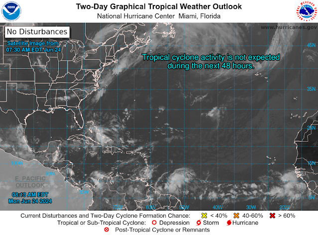
The tropics remain quiet for now; however, after the 4th of July, I will have to monitor the eastern Caribbean as the ensemble models show possible development as waves near the Lesser Antilles enter the east Caribbean.

RTW


ZCZC MIATWOAT ALL
TTAA00 KNHC DDHHMM

Tropical Weather Outlook
NWS National Hurricane Center Miami FL
800 AM EDT Mon Jun 24 2024

For the North Atlantic...Caribbean Sea and the Gulf of Mexico:

Tropical cyclone formation is not expected during the next 7 days.

$$
Forecaster Hagen/Pasch
------------------------------------------------------------------
861 
ACCA62 KNHC 241137
TWOSAT

Perspectiva sobre las Condiciones del Tiempo en el Trópico
Centro Nacional de Huracanes del SNM Miami FL
800 AM EDT lunes 24 de junio de 2024

Para el Atlántico Norte...Mar Caribe y el Golfo de México:

No se espera la formación de ciclones tropicales durante los
próximos 7 días.

$$
Pronosticador Hagen/Pasch

*** Este producto ha sido procesado automáticamente utilizando un
programa de traducción y puede contener omisiones y errores. El
Servicio Nacional de Meteorología no puede garantizar la precisión
del texto convertido. De haber alguna duda, el texto en inglés es
siempre la versión autorizada. ***


787 
AXNT20 KNHC 241016
TWDAT 

Tropical Weather Discussion
NWS National Hurricane Center Miami FL
1205 UTC Mon Jun 24 2024

Tropical Weather Discussion for North America, Central America
Gulf of Mexico, Caribbean Sea, northern sections of South
America, and Atlantic Ocean to the African coast from the
Equator to 31N. The following information is based on satellite
imagery, weather observations, radar and meteorological analysis.

Based on 0600 UTC surface analysis and satellite imagery through 
0930 UTC.

...TROPICAL WAVES...

An eastern Atlantic tropical wave is along 25W, south of 15N, 
moving westward at 10-15 kt. Scattered showers are noted along 
the wave's axis.

A central Atlantic tropical wave has is along 45W, south of 13N, 
moving westward at 15 kt. Scattered showers are noted along 
the wave's axis.

Another central Atlantic tropical wave is along 58W, south of 
20N, moving westward at 15 kt. Scattered moderate convection is  
noted along the wave's axis, from 10N-14N. 

A central Caribbean tropical wave is along 70W, south of 16N, 
moving westward at 10-15 kt. No significant convection is noted at
this time.

A western Caribbean/EPAC tropical wave is along 87W, south of 
18N, moving westward at 10-15 kt. Scattered showers and isolated 
thunderstorms are within 120 nm W of the wave axis south of 14N, 
affecting the Gulf of Honduras.

...MONSOON TROUGH/ITCZ...

The monsoon trough enters the Atlantic through the coast of
Senegal near 12N17W and continues southwestward to 08N26W. The 
ITCZ extends from 08N26W to 08N58W. Scattered moderate to 
isolated strong convection is present from 02N to 12N and east of
24W and from 06N to 12N and between 47W and 57W. Lighter activity
prevails along the ITCZ between 26W-42W.

...GULF OF MEXICO...

The basin is under generally dry conditions. Moderate to fresh 
easterly winds and seas of 4-6 ft are occurring in the western 
Gulf. In the remainder of the basin, moderate or weaker winds and
slight to moderate seas prevail.

For the forecast, moderate to fresh SE winds and moderate seas 
prevail across the area W of 90W, while gentle winds and slight 
seas prevail E of 90W. Similar conditions are expected through the
week, as a weak high pressure builds over the E central Gulf Tue 
through Thu.  

...CARIBBEAN SEA...

Refer to the section above for details on the tropical waves
moving across the basin.

Divergence aloft and plenty of tropical moisture continue to
enhance the showers and isolated thunderstorms across the Greater
Antilles and surrounding waters. Similar convection is noted off
NW Colombia, off eastern Yucatan and NE Caribbean, also affecting
the Leeward Islands. An expansive subtropical ridge centered
between Bermuda and the Azores extends southwestward into the
Caribbean Sea. The ridge is forcing fresh to strong easterly 
winds in the south-central Caribbean. Seas in these waters are 
4-7 ft. Moderate or weaker winds and slight to moderate seas are 
prevalent elsewhere.

For the forecast, surface ridging prevails across the Atlantic 
basin. With this, moderate to fresh trade winds will continue 
across the eastern and central Caribbean through tonight, pulsing 
to strong speeds at night near the coast over the south-central 
basin. Moderate trade winds and moderate seas are will prevail 
across the western basin through the week, except for winds 
pulsing to strong speeds at night in the Gulf of Honduras through 
this morning. Fresh to strong trades will accompany a tropical 
wave moving across the eastern basin Tue through early Wed and 
across the central basin Wed through Thu. 

...ATLANTIC OCEAN...

Refer to the section above for details on the tropical waves
moving across the basin.

Divergence aloft and abundant tropical moisture result in
scattered showers and isolated thunderstorms impacting the 
Bahamas and surrounding waters. In the remainder of the tropical 
Atlantic, Saharan dust and subsidence allow for drier conditions. 

An expansive subtropical ridge is centered between Bermuda and 
the Azores. Fresh to strong southerly winds and seas of 4-6 ft 
are occurring north of 30N and west of 75W. The pressure gradient
between the aforementioned ridge and lower pressures in the deep 
tropics sustain fresh to strong NE-E winds south of 25N and 
between 30W and 60W. Seas in these waters are 8-10 ft, with the 
highest seas occurring near 11N47W. Moderate to fresh NE winds and
seas of 5-8 ft are present east of 30W. Elsewhere in the basin, 
moderate or weaker winds and moderate seas are prevalent.

For the forecast west of 55W, fresh southerly winds and moderate 
seas will prevail across the waters N of 30N and W of 75W through 
today. Gentle to moderate E to SE winds will prevail elsewhere 
across the region through Wed, becoming SE to S winds W of 65W. 
High pressure north of the region will build SW into the NW 
Bahamas tonight through Tue, then shift NE and weaken through Thu.
Fresh to strong winds across the waters E of the Lesser Antilles 
will prevail through Tue associated with the passage of a tropical
wave.

$$
ERA


Friday, June 21, 2024

..TRACKING THE TROPICS UPDATE JUNE 21, 2024..


Other than these two system, elsewhere in the tropics all remains quiet for now!

RTW

ZCZC MIATWOAT ALL
TTAA00 KNHC DDHHMM

Tropical Weather Outlook
NWS National Hurricane Center Miami FL
800 AM EDT Fri Jun 21 2024

For the North Atlantic...Caribbean Sea and the Gulf of Mexico:

1. Southwestern Atlantic Ocean (AL92):
A small area of showers and thunderstorms persists with a low
pressure system located around 150 miles east-southeast of
Jacksonville, Florida. An Air Force Reserve aircraft is currently
investigating the system to determine if the low has a well-defined
surface circulation. Environmental conditions remain marginally
conducive for some additional development, and this system could
become a short-lived tropical depression as the low moves
west-northwestward at 10 to 15 mph. The system is expected to reach
the coast of northeastern Florida or Georgia by tonight, and
interests there should monitor its progress.
* Formation chance through 48 hours...medium...50 percent.
* Formation chance through 7 days...medium...50 percent.
2. Southwestern Gulf of Mexico:
A broad area of low pressure is forecast to form over southeastern
Mexico later today. Environmental conditions appear conducive for
gradual development after this system moves over the Bay of Campeche
tonight, and a tropical depression could form over the southwestern
Gulf of Mexico this weekend while it moves slowly west-northwestward
or northwestward. Interests along the Gulf coast of Mexico should
monitor the progress of this system.
* Formation chance through 48 hours...medium...50 percent.
* Formation chance through 7 days...medium...60 percent.

Forecaster Hagen/Berg